The NG18 postcode district is a postal district located in the NG Nottingham postcode area with a population of 45,052 residents according to the 2021 England and Wales Census.
The area of the NG18 postcode district is 10.12 square miles which is 26.20 square kilometres or 6,474.01 acres.
Currently, the NG18 district has about 1176 postcode units spread across 5 geographic postcode sectors.
Given that each sector allows for 400 unique postcode combinations, the district has a capacity of 2,000 postcodes. With 1176 postcodes already in use, this leaves 824 units available.
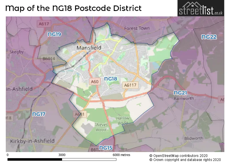
The NG18 postal code covers the settlement of MANSFIELD.
The NG18 Postcode shares a border with NG17 (SUTTON-IN-ASHFIELD, Kirkby-in-Ashfield, Huthwaite), NG15 (Hucknall, Ravenshead, Annesley) and NG19 (Mansfield Woodhouse, MANSFIELD, Forest Town).
The primary settlement in the NG18 postcode district is Mansfield, located in Nottinghamshire, England. Other significant settlements in the district include Harlow Wood and Sherwood Oaks Business Park. The post town associated with this district is Mansfield, which has the highest number of postcodes.
For the district NG18, we have data on 7 postcode sectors. Here's a breakdown: The sector NG18 1, covers Mansfield in Nottinghamshire. The sector NG18 2, covers Mansfield in Nottinghamshire. The sector NG18 3, covers Mansfield in Nottinghamshire. The sector NG18 4, covers Mansfield in Nottinghamshire. The sector NG18 5, covers Mansfield in Nottinghamshire. The sector NG18 6 is non-geographic. It's often designated for PO Boxes, large organisations, or special services. The sector NG18 9 is non-geographic. It's often designated for PO Boxes, large organisations, or special services.


Map of the NG18 Postcode District
Explore the NG18 postcode district by using our free interactive map.
When it comes to local government, postal geography often disregards political borders. However, for a breakdown in the NG18 District: the district mostly encompasses the Mansfield District (1183 postcodes), and finally, the Ashfield District area (17 postcodes).
Recent House Sales in NG18
| Date | Price | Address |
|---|---|---|
| 16/10/2023 | £137,500 | Dunwoody Close, Mansfield, NG18 3FD |
| 06/10/2023 | £100,000 | Old Bakery Way, Mansfield, NG18 2JR |
| 29/09/2023 | £223,000 | Avon Way, Mansfield, NG18 3NZ |
| 15/09/2023 | £109,000 | St Johns View, Mansfield, NG18 1QP |
| 08/09/2023 | £190,000 | Valley View, Mansfield, NG18 4US |
| 08/09/2023 | £122,500 | Broxtowe Drive, Mansfield, NG18 2JE |
| 08/09/2023 | £138,000 | Montague Street, Mansfield, NG18 2PL |
| 06/09/2023 | £114,000 | Redcliffe Road, Mansfield, NG18 2QN |
| 04/09/2023 | £192,500 | Garnon Street, Mansfield, NG18 5QT |
| 01/09/2023 | £177,500 | Little Barn Lane, Mansfield, NG18 3JJ |
Weather Forecast for NG18
Press Button to Show Forecast for Mansfield
| Time Period | Icon | Description | Temperature | Rain Probability | Wind |
|---|---|---|---|---|---|
| 15:00 to 18:00 | Heavy rain | 7.0°C (feels like 4.0°C) | 77.00% | NNE 7 mph | |
| 18:00 to 21:00 | Cloudy | 7.0°C (feels like 4.0°C) | 9.00% | ENE 7 mph | |
| 21:00 to 00:00 | Cloudy | 6.0°C (feels like 4.0°C) | 5.00% | ENE 7 mph |
Press Button to Show Forecast for Mansfield
| Time Period | Icon | Description | Temperature | Rain Probability | Wind |
|---|---|---|---|---|---|
| 00:00 to 03:00 | Cloudy | 5.0°C (feels like 3.0°C) | 4.00% | NE 4 mph | |
| 03:00 to 06:00 | Cloudy | 3.0°C (feels like 1.0°C) | 5.00% | NNE 4 mph | |
| 06:00 to 09:00 | Cloudy | 4.0°C (feels like 1.0°C) | 4.00% | NNE 7 mph | |
| 09:00 to 12:00 | Cloudy | 8.0°C (feels like 5.0°C) | 10.00% | NE 11 mph | |
| 12:00 to 15:00 | Overcast | 9.0°C (feels like 7.0°C) | 23.00% | ENE 9 mph | |
| 15:00 to 18:00 | Overcast | 9.0°C (feels like 6.0°C) | 18.00% | ENE 11 mph | |
| 18:00 to 21:00 | Overcast | 8.0°C (feels like 5.0°C) | 12.00% | NE 11 mph | |
| 21:00 to 00:00 | Overcast | 6.0°C (feels like 3.0°C) | 11.00% | NE 9 mph |
Press Button to Show Forecast for Mansfield
| Time Period | Icon | Description | Temperature | Rain Probability | Wind |
|---|---|---|---|---|---|
| 00:00 to 03:00 | Overcast | 6.0°C (feels like 2.0°C) | 10.00% | NNE 11 mph | |
| 03:00 to 06:00 | Light rain | 5.0°C (feels like 2.0°C) | 57.00% | N 11 mph | |
| 06:00 to 09:00 | Heavy rain | 5.0°C (feels like 1.0°C) | 81.00% | N 13 mph | |
| 09:00 to 12:00 | Heavy rain | 6.0°C (feels like 2.0°C) | 83.00% | NNW 13 mph | |
| 12:00 to 15:00 | Light rain | 7.0°C (feels like 4.0°C) | 47.00% | NW 11 mph | |
| 15:00 to 18:00 | Cloudy | 9.0°C (feels like 7.0°C) | 15.00% | WNW 9 mph | |
| 18:00 to 21:00 | Sunny day | 9.0°C (feels like 7.0°C) | 5.00% | W 9 mph | |
| 21:00 to 00:00 | Clear night | 7.0°C (feels like 5.0°C) | 3.00% | SW 7 mph |
Press Button to Show Forecast for Mansfield
| Time Period | Icon | Description | Temperature | Rain Probability | Wind |
|---|---|---|---|---|---|
| 00:00 to 03:00 | Clear night | 5.0°C (feels like 3.0°C) | 1.00% | SW 7 mph | |
| 03:00 to 06:00 | Clear night | 4.0°C (feels like 2.0°C) | 0.00% | SSW 7 mph | |
| 06:00 to 09:00 | Sunny day | 5.0°C (feels like 2.0°C) | 1.00% | SSW 7 mph | |
| 09:00 to 12:00 | Partly cloudy (day) | 10.0°C (feels like 7.0°C) | 1.00% | S 11 mph | |
| 12:00 to 15:00 | Cloudy | 13.0°C (feels like 10.0°C) | 5.00% | S 13 mph | |
| 15:00 to 18:00 | Cloudy | 14.0°C (feels like 11.0°C) | 17.00% | S 13 mph | |
| 18:00 to 21:00 | Partly cloudy (day) | 13.0°C (feels like 11.0°C) | 3.00% | S 11 mph | |
| 21:00 to 00:00 | Clear night | 10.0°C (feels like 8.0°C) | 2.00% | SSE 9 mph |
Press Button to Show Forecast for Mansfield
| Time Period | Icon | Description | Temperature | Rain Probability | Wind |
|---|---|---|---|---|---|
| 00:00 to 03:00 | Clear night | 8.0°C (feels like 6.0°C) | 2.00% | SSE 9 mph | |
| 03:00 to 06:00 | Clear night | 6.0°C (feels like 4.0°C) | 2.00% | SE 7 mph | |
| 06:00 to 09:00 | Sunny day | 7.0°C (feels like 5.0°C) | 4.00% | ESE 7 mph | |
| 09:00 to 12:00 | Cloudy | 11.0°C (feels like 9.0°C) | 7.00% | ESE 9 mph | |
| 12:00 to 15:00 | Partly cloudy (day) | 15.0°C (feels like 12.0°C) | 5.00% | ESE 11 mph | |
| 15:00 to 18:00 | Cloudy | 15.0°C (feels like 13.0°C) | 10.00% | ESE 11 mph | |
| 18:00 to 21:00 | Partly cloudy (day) | 14.0°C (feels like 12.0°C) | 7.00% | ESE 9 mph | |
| 21:00 to 00:00 | Cloudy | 11.0°C (feels like 10.0°C) | 9.00% | E 7 mph |
Where is the NG18 Postcode District?
The postcode district for NG18 is located in Mansfield. It is surrounded by nearby towns, including Sutton-in-Ashfield to the West (approximately 3.6 miles away), Nottingham to the South (approximately 9.7 miles away), Southwell to the South East (approximately 9.8 miles away), Heanor to the South West (approximately 10.8 miles away), Chesterfield to the North West (approximately 11.6 miles away), and Worksop to the North (approximately 12 miles away). Additionally, the distance from this postcode district to the center of London is approximately 120.6 miles.
The district is within the post town of MANSFIELD.
The sector has postcodes within the nation of England.
The NG18 Postcode District is in the North Nottinghamshire region of Derbyshire and Nottinghamshire within the East Midlands (England).
| Postcode Sector | Delivery Office |
|---|---|
| NG18 1 | Mansfield Delivery Office |
| NG18 2 | Mansfield Delivery Office |
| NG18 3 | Mansfield Delivery Office |
| NG18 4 | Mansfield Delivery Office |
| NG18 5 | Mansfield Delivery Office |
| N | G | 1 | 8 | - | X | X | X |
| N | G | 1 | 8 | Space | Numeric | Letter | Letter |
Tourist Attractions within the Postcode Area
We found 1 visitor attractions within the NG18 postcode area
| Mansfield Museum |
|---|
| Museums & Art Galleries |
| Museum and / or Art Gallery |
| View Mansfield Museum on Google Maps |
Current Monthly Rental Prices
| # Bedrooms | Min Price | Max Price | Avg Price |
|---|---|---|---|
| 1 | £425 | £675 | £569 |
| 2 | £625 | £1,200 | £744 |
| 3 | £750 | £1,295 | £957 |
| 4 | £950 | £1,450 | £1,156 |
| 10 | £325 | £325 | £325 |
Current House Prices
| # Bedrooms | Min Price | Max Price | Avg Price |
|---|---|---|---|
| £100 | £250,000 | £120,033 | |
| 1 | £60,000 | £75,000 | £66,667 |
| 2 | £70,000 | £470,000 | £181,733 |
| 3 | £80,000 | £589,950 | £237,649 |
| 4 | £125,000 | £775,000 | £375,801 |
| 5 | £250,000 | £1,395,000 | £642,200 |
| 6 | £250,000 | £1,250,000 | £723,333 |
| 7 | £695,500 | £695,500 | £695,500 |
| 18 | £1,000,000 | £1,000,000 | £1,000,000 |
Estate Agents who Operate in the NG18 District
| Logo | Name | Brand Name | Address | Contact Number | Total Properties |
|---|---|---|---|---|---|
 | Mansfield | BuckleyBrown | 55-57 Leeming Street, Mansfield, Notts, NG18 1ND | 01623 705218 | 94 |
 | Mansfield | Richard Watkinson & Partners | 1 Albert Street, Mansfield, NG18 1EA | 01623 700874 | 22 |
 | Mansfield | Bairstow Eves | 38a West Gate Mansfield NG18 1RS | 01623 700731 | 21 |
 | Mansfield | Frank Innes | 44 Low Street Sutton-In-Ashfield NG17 1DG | 01623 701405 | 15 |
 | Mansfield | John Sankey | 41 Albert Street, Mansfield, NG18 1EA | 01623 705319 | 14 |
| Type of Property | 2018 Average | 2018 Sales | 2017 Average | 2017 Sales | 2016 Average | 2016 Sales | 2015 Average | 2015 Sales |
|---|---|---|---|---|---|---|---|---|
| Detached | £254,592 | 280 | £236,565 | 276 | £231,446 | 311 | £214,005 | 242 |
| Semi-Detached | £126,607 | 256 | £121,647 | 252 | £125,988 | 265 | £119,778 | 242 |
| Terraced | £91,433 | 177 | £95,863 | 187 | £95,471 | 197 | £87,557 | 216 |
| Flats | £84,812 | 43 | £93,179 | 38 | £91,422 | 52 | £80,989 | 38 |