The NG23 postcode district is a postal district located in the NG Nottingham postcode area with a population of 18,103 residents according to the 2021 England and Wales Census.
The area of the NG23 postcode district is 121.00 square miles which is 313.40 square kilometres or 77,442.20 acres.
Currently, the NG23 district has about 760 postcode units spread across 3 geographic postcode sectors.
Given that each sector allows for 400 unique postcode combinations, the district has a capacity of 1,200 postcodes. With 760 postcodes already in use, this leaves 440 units available.
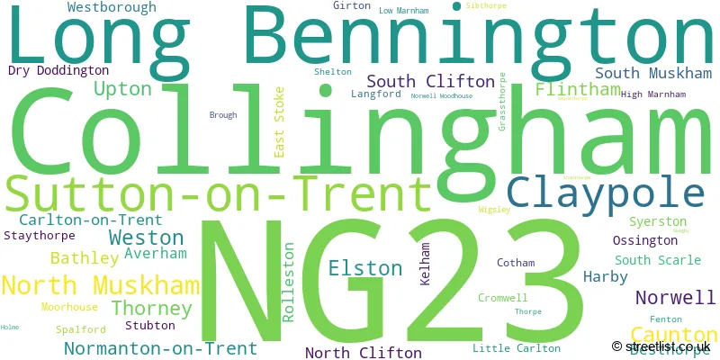
The largest settlement in the NG23 postal code is Collingham followed by Long Bennington, and Sutton-on-Trent.
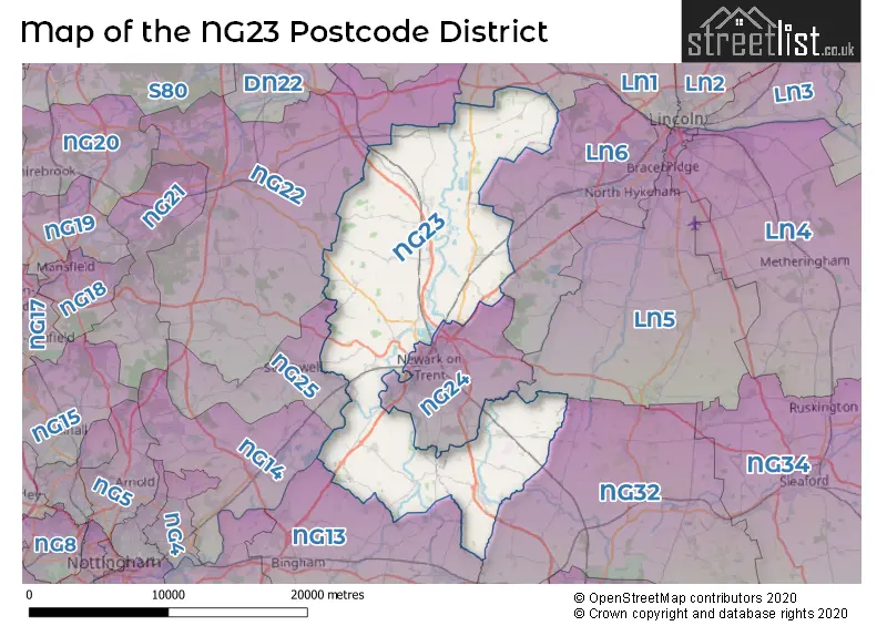
The NG23 Postcode shares a border with LN5 (LINCOLN, Waddington, Navenby), LN1 (LINCOLN, Saxilby, Sturton By Stow), NG22 (New Ollerton, Bilsthorpe, Tuxford), NG24 (NEWARK, Balderton, Fernwood), NG25 (SOUTHWELL, Fiskerton, Oxton), NG32 (Barrowby, Ancaster, Caythorpe), LN6 (LINCOLN, North Hykeham, Skellingthorpe) and NG13 (Bingham, Bottesford, East Bridgford).
The primary settlement in the NG23 postcode district is Long Bennington, located in the county of Lincolnshire. Other significant settlements in this district include Averham, Claypole, Cotham, Dry Doddington, East Stoke, Elston, Fenton, Flintham, Kelham, Rolleston, Shelton, Sibthorpe, Staythorpe, Stubton, Syerston, Thorpe, Upton, Westborough, Bathley, Carlton-on-Trent, Caunton, Cromwell, Grassthorpe, High Marnham, Knapthorpe, Little Carlton, Low Marnham, Moorhouse, Normanton-on-Trent, North Muskham, Norwell, Norwell Woodhouse, Ossington, Skegby, South Muskham, Sutton-on-Trent, Weston, Besthorpe, Brough, Collingham, Girton, Harby, Holme, Langford, North Clifton, South Clifton, South Scarle, Spalford, Swinethorpe, Thorney, and Wigsley. The most significant post town in this district is Newark, located in the county of Nottinghamshire within England.
For the district NG23, we have data on 3 postcode sectors. Here's a breakdown: The sector NG23 5, covers Long Bennington and Claypole in Lincolnshire. The sector NG23 6, covers Sutton-On-Trent and North Muskham and Caunton in Nottinghamshire. The sector NG23 7, covers Collingham in Nottinghamshire.

Map of the NG23 Postcode District
Explore the NG23 postcode district by using our free interactive map.
When it comes to local government, postal geography often disregards political borders. However, for a breakdown in the NG23 District: the district mostly encompasses the Newark and Sherwood District (569 postcodes), followed by the South Kesteven District area (142 postcodes), followed by the Bassetlaw District area (30 postcodes), and finally, the Rushcliffe District (B) area (26 postcodes).
Recent House Sales in NG23
| Date | Price | Address |
|---|---|---|
| 05/10/2023 | £265,000 | Curtis Close, Collingham, Newark, NG23 7QW |
| 02/10/2023 | £350,000 | Trent Lane, North Clifton, Newark, NG23 7AT |
| 26/09/2023 | £465,000 | Silver Street, North Clifton, Newark, NG23 7AU |
| 22/09/2023 | £415,000 | Baptist Lane, Collingham, Newark, NG23 7LT |
| 14/09/2023 | £500,000 | Woodhouse Road, Norwell, Newark, NG23 6JX |
| 07/09/2023 | £515,000 | Main Street, North Muskham, Newark, NG23 6HQ |
| 05/09/2023 | £945,000 | Fiskerton Road, Rolleston, Newark, NG23 5SL |
| 29/08/2023 | £290,000 | Vicarage Lane, North Muskham, Newark, NG23 6DU |
| 25/08/2023 | £223,000 | The Meadows, Long Bennington, Newark, NG23 5EL |
| 23/08/2023 | £305,000 | The Poppyfields, Collingham, Newark, NG23 7SE |
Where is the NG23 Postcode District?
The postcode district NG23 is located in the town of Newark. It is situated in close proximity to several nearby towns. To the South West is Southwell, which is approximately 7.4 miles away. To the North East is Lincoln, which is around 12.9 miles away. To the North is Retford, located approximately 14.7 miles away. To the South East is Grantham, which is about 16.1 miles away. To the West is Mansfield, located approximately 16.1 miles away. Lastly, to the North West is Worksop, which is approximately 18.1 miles away. Furthermore, the postcode district NG23 is approximately 114.6 miles away from the centre of London.
The district is within the post town of NEWARK.
The sector has postcodes within the nation of England.
The NG23 Postcode District is covers the following regions.
- Lincolnshire - Lincolnshire - East Midlands (England)
- North Nottinghamshire - Derbyshire and Nottinghamshire - East Midlands (England)
- South Nottinghamshire - Derbyshire and Nottinghamshire - East Midlands (England)
Weather Forecast for NG23
Press Button to Show Forecast for Newark
| Time Period | Icon | Description | Temperature | Rain Probability | Wind |
|---|---|---|---|---|---|
| 21:00 to 00:00 | Cloudy | 12.0°C (feels like 11.0°C) | 4.00% | NNE 9 mph |
Press Button to Show Forecast for Newark
| Time Period | Icon | Description | Temperature | Rain Probability | Wind |
|---|---|---|---|---|---|
| 00:00 to 03:00 | Overcast | 10.0°C (feels like 7.0°C) | 10.00% | N 13 mph | |
| 03:00 to 06:00 | Overcast | 9.0°C (feels like 7.0°C) | 10.00% | N 13 mph | |
| 06:00 to 09:00 | Overcast | 10.0°C (feels like 8.0°C) | 10.00% | NNE 13 mph | |
| 09:00 to 12:00 | Cloudy | 14.0°C (feels like 11.0°C) | 9.00% | NNE 13 mph | |
| 12:00 to 15:00 | Cloudy | 17.0°C (feels like 15.0°C) | 31.00% | NE 13 mph | |
| 15:00 to 18:00 | Partly cloudy (day) | 17.0°C (feels like 14.0°C) | 31.00% | NE 13 mph | |
| 18:00 to 21:00 | Cloudy | 14.0°C (feels like 12.0°C) | 8.00% | NNE 11 mph | |
| 21:00 to 00:00 | Overcast | 11.0°C (feels like 9.0°C) | 9.00% | NNE 9 mph |
Press Button to Show Forecast for Newark
| Time Period | Icon | Description | Temperature | Rain Probability | Wind |
|---|---|---|---|---|---|
| 00:00 to 03:00 | Overcast | 10.0°C (feels like 9.0°C) | 9.00% | N 7 mph | |
| 03:00 to 06:00 | Overcast | 10.0°C (feels like 9.0°C) | 10.00% | NNW 7 mph | |
| 06:00 to 09:00 | Overcast | 11.0°C (feels like 9.0°C) | 14.00% | NW 7 mph | |
| 09:00 to 12:00 | Light rain | 12.0°C (feels like 11.0°C) | 56.00% | WNW 7 mph | |
| 12:00 to 15:00 | Light rain | 13.0°C (feels like 12.0°C) | 57.00% | W 7 mph | |
| 15:00 to 18:00 | Heavy rain | 14.0°C (feels like 12.0°C) | 76.00% | W 11 mph | |
| 18:00 to 21:00 | Light rain | 13.0°C (feels like 11.0°C) | 53.00% | WSW 11 mph | |
| 21:00 to 00:00 | Light rain | 12.0°C (feels like 10.0°C) | 47.00% | WSW 11 mph |
Press Button to Show Forecast for Newark
| Time Period | Icon | Description | Temperature | Rain Probability | Wind |
|---|---|---|---|---|---|
| 00:00 to 03:00 | Light rain | 11.0°C (feels like 9.0°C) | 43.00% | WSW 9 mph | |
| 03:00 to 06:00 | Cloudy | 9.0°C (feels like 7.0°C) | 10.00% | SW 9 mph | |
| 06:00 to 09:00 | Partly cloudy (day) | 10.0°C (feels like 8.0°C) | 4.00% | SW 9 mph | |
| 09:00 to 12:00 | Cloudy | 13.0°C (feels like 11.0°C) | 7.00% | SW 11 mph | |
| 12:00 to 15:00 | Cloudy | 15.0°C (feels like 13.0°C) | 8.00% | SW 11 mph | |
| 15:00 to 18:00 | Cloudy | 17.0°C (feels like 15.0°C) | 9.00% | SSW 9 mph | |
| 18:00 to 21:00 | Cloudy | 16.0°C (feels like 15.0°C) | 10.00% | SSW 4 mph | |
| 21:00 to 00:00 | Cloudy | 11.0°C (feels like 10.0°C) | 9.00% | SSE 7 mph |
Press Button to Show Forecast for Newark
| Time Period | Icon | Description | Temperature | Rain Probability | Wind |
|---|---|---|---|---|---|
| 00:00 to 03:00 | Partly cloudy (night) | 11.0°C (feels like 9.0°C) | 5.00% | SSE 7 mph | |
| 03:00 to 06:00 | Partly cloudy (night) | 9.0°C (feels like 8.0°C) | 6.00% | S 4 mph | |
| 06:00 to 09:00 | Cloudy | 10.0°C (feels like 9.0°C) | 14.00% | SSE 7 mph | |
| 09:00 to 12:00 | Cloudy | 13.0°C (feels like 12.0°C) | 11.00% | SE 7 mph | |
| 12:00 to 15:00 | Cloudy | 15.0°C (feels like 14.0°C) | 13.00% | SE 9 mph | |
| 15:00 to 18:00 | Light rain | 15.0°C (feels like 14.0°C) | 45.00% | SSE 7 mph | |
| 18:00 to 21:00 | Light rain shower (day) | 14.0°C (feels like 13.0°C) | 33.00% | SSE 7 mph | |
| 21:00 to 00:00 | Cloudy | 12.0°C (feels like 11.0°C) | 8.00% | ESE 7 mph |
| Postcode Sector | Delivery Office |
|---|---|
| NG23 5 | Newark Delivery Office |
| NG23 6 | Newark Delivery Office |
| NG23 7 | Newark Delivery Office |
| N | G | 2 | 3 | - | X | X | X |
| N | G | 2 | 3 | Space | Numeric | Letter | Letter |
Tourist Attractions within the Postcode Area
We found 3 visitor attractions within the NG23 postcode area
| Upton Hall Time Museum |
|---|
| Museums & Art Galleries |
| Museum and / or Art Gallery |
| View Upton Hall Time Museum on Google Maps |
| Flintham Museum |
| Museums & Art Galleries |
| Museum and / or Art Gallery |
| View Flintham Museum on Google Maps |
| Pureland Meditation Centre and Japanese Garden |
| Gardens |
| Garden |
| View Pureland Meditation Centre and Japanese Garden on Google Maps |
Current Monthly Rental Prices
| # Bedrooms | Min Price | Max Price | Avg Price |
|---|---|---|---|
| 1 | £495 | £900 | £698 |
| 2 | £700 | £1,200 | £933 |
| 3 | £1,100 | £1,200 | £1,133 |
| 4 | £1,850 | £5,800 | £3,825 |
| 5 | £2,000 | £2,100 | £2,050 |
Current House Prices
| # Bedrooms | Min Price | Max Price | Avg Price |
|---|---|---|---|
| £210,000 | £2,500,000 | £716,875 | |
| 1 | £55,000 | £175,000 | £142,500 |
| 2 | £50,000 | £595,000 | £244,833 |
| 3 | £150,000 | £750,000 | £359,205 |
| 4 | £350,000 | £1,250,000 | £555,318 |
| 5 | £325,000 | £2,300,000 | £706,935 |
| 6 | £450,000 | £900,000 | £750,000 |
| 7 | £650,000 | £3,950,000 | £1,950,000 |
| 8 | £975,000 | £975,000 | £975,000 |
Estate Agents who Operate in the NG23 District
| Logo | Name | Brand Name | Address | Contact Number | Total Properties |
|---|---|---|---|---|---|
 | Newark | Richard Watkinson & Partners | 35 Kirk Gate, Newark, Nottinghamshire, NG24 1AD | 01636 556093 | 25 |
 | Newark | Alasdair Morrison and Partners | 26 Kirk Gate, Newark, NG24 1AB | 01636 555806 | 19 |
 | Newark | Newton Fallowell | 12 ? 14 Middle Gate Newark NG24 1AG | 01636 555744 | 16 |
 | Newark | William H. Brown | Newark, | 01636 555688 | 16 |
 | Newark | Oliver Reilly | 4 Middle Gate, Newark, NG24 1AG | 01636 555672 | 10 |
- Averham
- Bathley
- Besthorpe
- Broadholme
- Brough
- Carlton-on-Trent
- Caunton
- Claypole
- Collingham
- Cotham
- Cromwell
- Drinsey Nook
- Dry Doddington
- East Stoke
- Elston
- Farndon
- Fenton
- Fiskerton
- Flintham
- Girton
- Grassthorpe
- Harby
- High Marnham
- Hockerton
- Holme
- Kelham
- Langford
- Little Carlton
- Long Bennington
- Low Marnham
- Moorhouse
- Newark-on-Trent
- Normanton
- Normanton on Trent
- North Clifton
- North Muskham
- North Scarle
- Norwell
- Ossington
- Rolleston
- Shelton
- Sibthorpe
- South Clifton
- South Muskham
- South Scarle
- Spalford
- Staythorpe
- Stubton
- Sutton on Trent
- Syerston
- Thorney Moor
- Thorney
- Tuxford
- Upton
- Westborough
- Weston
- Wigsley
- Winthorpe
| Type of Property | 2018 Average | 2018 Sales | 2017 Average | 2017 Sales | 2016 Average | 2016 Sales | 2015 Average | 2015 Sales |
|---|---|---|---|---|---|---|---|---|
| Detached | £341,885 | 209 | £313,067 | 190 | £313,166 | 216 | £292,605 | 244 |
| Semi-Detached | £202,736 | 53 | £205,603 | 43 | £189,848 | 70 | £176,396 | 77 |
| Terraced | £204,436 | 21 | £202,804 | 24 | £159,372 | 32 | £169,385 | 40 |
| Flats | £144,333 | 3 | £175,000 | 1 | £145,000 | 1 | £113,500 | 2 |