The OX49 postcode district is a postal district located in the OX Oxford postcode area with a population of 4,204 residents according to the 2021 England and Wales Census.
The area of the OX49 postcode district is 23.27 square miles which is 60.27 square kilometres or 14,894.06 acres.
Currently, the OX49 district has about 216 postcode units spread across 1 geographic postcode sectors.
Given that each sector allows for 400 unique postcode combinations, the district has a capacity of 400 postcodes. With 216 postcodes already in use, this leaves 184 units available.
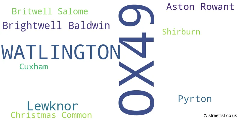
The largest settlement in the OX49 postal code is WATLINGTON followed by Lewknor, and Aston Rowant.
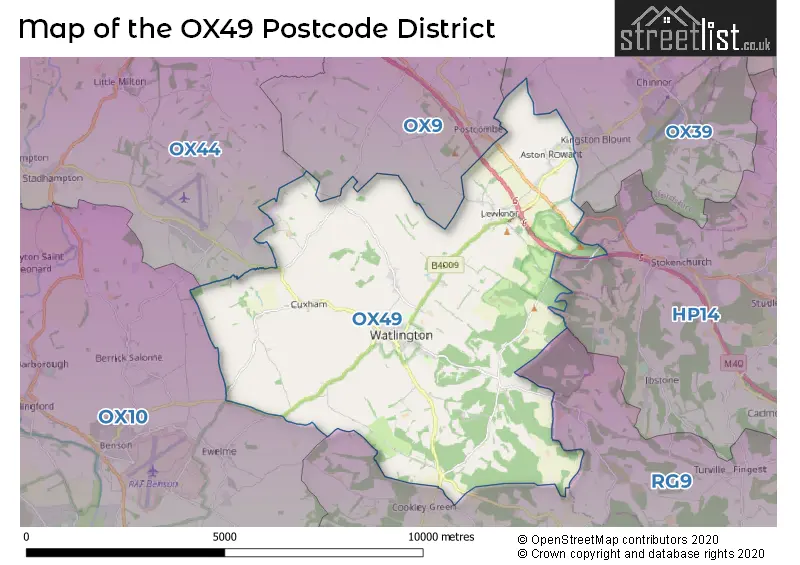
The OX49 Postcode shares a border with OX10 (WALLINGFORD, Benson, Cholsey), OX9 (THAME, Tetsworth, Tiddington), HP14 (Stokenchurch, Lane End, Walters Ash), RG9 (HENLEY-ON-THAMES, Hambleden, Shiplake), OX39 (CHINNOR, Kingston Blount, Sydenham) and OX44 (Chalgrove, Garsington, Stadhampton).
In the OX49 postcode district in Oxfordshire, the primary settlement is Watlington. Other significant settlements include Aston Rowant, Brightwell Baldwin, Britwell Salome, Christmas Common, Cuxham, Lewknor, Pyrton, and Shirburn. The most significant post town is Watlington.
For the district OX49, we have data on 1 postcode sectors. Here's a breakdown: The sector OX49 5, covers Watlington and Lewknor in Oxfordshire.
OX49 Postcode Sectors

Map of the OX49 Postcode District
Explore the OX49 postcode district by using our free interactive map.
When it comes to local government, postal geography often disregards political borders. However, for a breakdown in the OX49 District: the district mostly encompasses the South Oxfordshire District area with a total of 228 postcodes.
Recent House Sales in OX49
| Date | Price | Address |
|---|---|---|
| 22/09/2023 | £427,000 | High Street, Lewknor, Watlington, OX49 5TH |
| 07/09/2023 | £340,000 | Shirburn Street, Watlington, OX49 5BT |
| 31/08/2023 | £820,000 | Cuxham Road, Watlington, OX49 5JW |
| 11/08/2023 | £350,000 | Sycamore Close, Watlington, OX49 5LN |
| 02/08/2023 | £750,000 | Church Street, Watlington, OX49 5QR |
| 25/07/2023 | £765,000 | Nethercote Lane, Lewknor, Watlington, OX49 5RX |
| 25/07/2023 | £1,000,000 | Stonor Green, Watlington, OX49 5PT |
| 25/07/2023 | £448,000 | Chestnut Place, Watlington, OX49 5RJ |
| 18/07/2023 | £475,000 | Chapel Street, Watlington, OX49 5QU |
| 30/06/2023 | £700,000 | Couching Street, Watlington, OX49 5QF |
Weather Forecast for OX49
Press Button to Show Forecast for Watlington
| Time Period | Icon | Description | Temperature | Rain Probability | Wind |
|---|---|---|---|---|---|
| 00:00 to 03:00 | Cloudy | 5.0°C (feels like 3.0°C) | 4.00% | ENE 7 mph | |
| 03:00 to 06:00 | Cloudy | 4.0°C (feels like 1.0°C) | 4.00% | ENE 7 mph | |
| 06:00 to 09:00 | Cloudy | 4.0°C (feels like 1.0°C) | 5.00% | ENE 7 mph | |
| 09:00 to 12:00 | Partly cloudy (day) | 7.0°C (feels like 5.0°C) | 3.00% | ENE 9 mph | |
| 12:00 to 15:00 | Cloudy | 9.0°C (feels like 8.0°C) | 9.00% | ENE 7 mph | |
| 15:00 to 18:00 | Overcast | 10.0°C (feels like 9.0°C) | 15.00% | ENE 4 mph | |
| 18:00 to 21:00 | Cloudy | 9.0°C (feels like 8.0°C) | 12.00% | NE 4 mph | |
| 21:00 to 00:00 | Cloudy | 6.0°C (feels like 4.0°C) | 13.00% | ENE 7 mph |
Press Button to Show Forecast for Watlington
| Time Period | Icon | Description | Temperature | Rain Probability | Wind |
|---|---|---|---|---|---|
| 00:00 to 03:00 | Cloudy | 4.0°C (feels like 2.0°C) | 12.00% | ENE 7 mph | |
| 03:00 to 06:00 | Cloudy | 3.0°C (feels like 1.0°C) | 18.00% | ENE 7 mph | |
| 06:00 to 09:00 | Cloudy | 4.0°C (feels like 2.0°C) | 22.00% | ENE 7 mph | |
| 09:00 to 12:00 | Overcast | 8.0°C (feels like 5.0°C) | 22.00% | ENE 9 mph | |
| 12:00 to 15:00 | Cloudy | 11.0°C (feels like 8.0°C) | 17.00% | ENE 11 mph | |
| 15:00 to 18:00 | Cloudy | 11.0°C (feels like 9.0°C) | 19.00% | ENE 11 mph | |
| 18:00 to 21:00 | Light rain | 10.0°C (feels like 8.0°C) | 51.00% | ENE 9 mph | |
| 21:00 to 00:00 | Light rain | 8.0°C (feels like 5.0°C) | 52.00% | NE 11 mph |
Press Button to Show Forecast for Watlington
| Time Period | Icon | Description | Temperature | Rain Probability | Wind |
|---|---|---|---|---|---|
| 00:00 to 03:00 | Heavy rain | 7.0°C (feels like 4.0°C) | 77.00% | NE 11 mph | |
| 03:00 to 06:00 | Heavy rain | 7.0°C (feels like 5.0°C) | 75.00% | NE 9 mph | |
| 06:00 to 09:00 | Heavy rain | 8.0°C (feels like 6.0°C) | 75.00% | ENE 7 mph | |
| 09:00 to 12:00 | Heavy rain shower (day) | 10.0°C (feels like 8.0°C) | 56.00% | ESE 9 mph | |
| 12:00 to 15:00 | Light rain | 11.0°C (feels like 9.0°C) | 54.00% | SSE 11 mph | |
| 15:00 to 18:00 | Light rain shower (day) | 11.0°C (feels like 9.0°C) | 40.00% | W 11 mph | |
| 18:00 to 21:00 | Light rain shower (day) | 10.0°C (feels like 8.0°C) | 34.00% | W 9 mph | |
| 21:00 to 00:00 | Partly cloudy (night) | 8.0°C (feels like 6.0°C) | 4.00% | WSW 7 mph |
Where is the OX49 Postcode District?
The postcode district of OX49 is located in the town of Watlington. Watlington is situated near several nearby towns, including Chinnor, Thame, Wallingford, High Wycombe, Henley-on-Thames, and Abingdon. Additionally, Watlington is approximately 38.8 miles away from the center of London.
The district is within the post town of WATLINGTON.
The sector has postcodes within the nation of England.
The OX49 Postcode District is in the Oxfordshire region of Berkshire, Buckinghamshire and Oxfordshire within the South East (England).
Postcode Sectors within the OX49 District
| Postcode Sector | Delivery Office |
|---|---|
| OX49 5 | Watlington (ox49) Delivery Office |
| O | X | 4 | 9 | - | X | X | X |
| O | X | 4 | 9 | Space | Numeric | Letter | Letter |
Current Monthly Rental Prices
| # Bedrooms | Min Price | Max Price | Avg Price |
|---|---|---|---|
| £75 | £75 | £75 |
Current House Prices
| # Bedrooms | Min Price | Max Price | Avg Price |
|---|---|---|---|
| £500,000 | £500,000 | £500,000 | |
| 1 | £179,000 | £295,000 | £217,667 |
| 2 | £185,000 | £620,000 | £470,625 |
| 3 | £390,000 | £750,000 | £514,500 |
| 4 | £575,000 | £1,575,000 | £1,016,333 |
| 5 | £1,060,000 | £1,675,000 | £1,257,000 |
| 6 | £1,500,000 | £1,500,000 | £1,500,000 |
Estate Agents who Operate in the OX49 District
| Logo | Name | Brand Name | Address | Contact Number | Total Properties |
|---|---|---|---|---|---|
 | Watlington | Robinson Sherston | 1 High Street, Watlington, OX49 5PZ | 01491 521018 | 7 |
 | Henley-On-Thames | Savills | 58-60 Bell Street, Henley-On-Thames, RG9 2BN | 01491 521671 | 5 |
 | Oxford | Knight Frank | Unit 3 274 Banbury Road, Summertown, Oxford, Oxfordshire, OX2 7DY | 01865 638863 | 3 |
 | Watlington | Griffith & Partners | 42 High Street, Watlington, OX49 5PY | 01491 527520 | 2 |
 | Princes Risborough | Michael Graham | 24 Market Square, Princes Risborough, HP27 0AN | 01844 393386 | 2 |
| Type of Property | 2018 Average | 2018 Sales | 2017 Average | 2017 Sales | 2016 Average | 2016 Sales | 2015 Average | 2015 Sales |
|---|---|---|---|---|---|---|---|---|
| Detached | £975,563 | 16 | £752,309 | 22 | £767,509 | 27 | £564,357 | 14 |
| Semi-Detached | £406,292 | 12 | £450,365 | 26 | £431,265 | 17 | £366,257 | 20 |
| Terraced | £414,375 | 12 | £380,467 | 15 | £416,382 | 22 | £342,283 | 23 |
| Flats | £212,500 | 2 | £178,333 | 6 | £178,313 | 4 | £123,498 | 2 |