The RH19 4 postcode sector stands on the East Sussex and West Sussex border.
Did you know? According to the 2021 Census, the RH19 4 postcode sector is home to a bustling 8,028 residents!
Given that each sector allows for 400 unique postcode combinations. Letters C, I, K, M, O and V are not allowed in the last two letters of a postcode. With 244 postcodes already in use, this leaves 156 units available.
The largest settlement in the RH19 4 postal code is EAST GRINSTEAD followed by Sharpthorne, and West Hoathly.
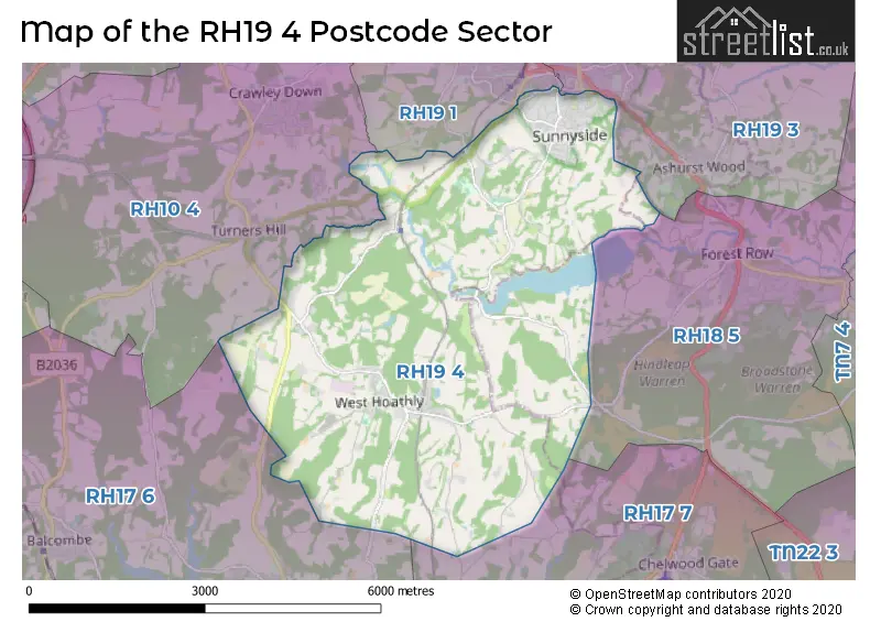
The RH19 4 Postcode shares a border with RH19 1 (EAST GRINSTEAD), RH19 3 (EAST GRINSTEAD, Ashurst Wood, Hammerwood), RH10 4 (Crawley Down, Turners Hill, Worth), RH17 6 (Balcombe, Ardingly, Handcross), RH17 7 (Horsted Keynes, Scaynes Hill, HAYWARDS HEATH) and RH18 5 (FOREST ROW, Wych Cross, Weir Wood).
The sector is within the post town of EAST GRINSTEAD.
RH19 4 is a postcode sector within the RH1 postcode district which is within the RH Redhill postcode area.
The Royal Mail delivery office for the RH19 4 postal sector is the Redhill Delivery Office.
The area of the RH19 4 postcode sector is 13.72 square miles which is 35.53 square kilometres or 8,779.24 square acres.


Map of the RH19 4 Postcode Sector
Explore the RH19 4 postcode sector by using our free interactive map.
| R | H | 1 | 9 | - | 4 | X | X |
| R | H | 1 | 9 | Space | 4 | Letter | Letter |
Official List of Streets
EAST GRINSTEAD (102 Streets)
West Hoathly (15 Streets)
Sharpthorne (15 Streets)
Kingscote (1 Streets)
Unofficial Streets or Alternative Spellings
EAST GRINSTEAD
COOMBE HALL PARK IMBERHORNE LANE LEWES ROAD OLD ROAD QUEENS ROAD QUEENSWAY ST. HILL GREEN ASPEN COURT BOWER HILL BROADHURST MANOR ROAD BULLDOG BANK CHAPEL ROW CINDER HILL COB LANE DEERS LEAP MAIN TRAIL FOREST WAY HIGH TREES IMAGE CROSS IMAGE CROSS, TOP ROAD JUDGES TERRACE MARTYNS PLACE MEWS COURT MILL COTTAGES MILLWOOD OLD ROAD OLD STONE LINK QUEENS ROAD SELSFIELD COMMON SHORTY SKILLS SECTION STONELANDS TOBIAS GREENWest Hoathly
BROAD FIELDArdingly
HAMMINGDEN LANE SELSFIELD ROADTurners Hill
SELSFIELD ROADWeather Forecast for RH19 4
Press Button to Show Forecast for Standen
| Time Period | Icon | Description | Temperature | Rain Probability | Wind |
|---|---|---|---|---|---|
| 09:00 to 12:00 | Partly cloudy (day) | 14.0°C (feels like 13.0°C) | 1.00% | SSE 4 mph | |
| 12:00 to 15:00 | Cloudy | 16.0°C (feels like 14.0°C) | 5.00% | SSE 9 mph | |
| 15:00 to 18:00 | Cloudy | 15.0°C (feels like 13.0°C) | 5.00% | S 9 mph | |
| 18:00 to 21:00 | Cloudy | 13.0°C (feels like 12.0°C) | 6.00% | SSE 4 mph | |
| 21:00 to 00:00 | Cloudy | 11.0°C (feels like 10.0°C) | 11.00% | ESE 4 mph |
Press Button to Show Forecast for Standen
| Time Period | Icon | Description | Temperature | Rain Probability | Wind |
|---|---|---|---|---|---|
| 00:00 to 03:00 | Overcast | 10.0°C (feels like 9.0°C) | 53.00% | E 4 mph | |
| 03:00 to 06:00 | Light rain | 10.0°C (feels like 9.0°C) | 57.00% | ENE 4 mph | |
| 06:00 to 09:00 | Light rain | 11.0°C (feels like 10.0°C) | 54.00% | ENE 4 mph | |
| 09:00 to 12:00 | Heavy rain | 12.0°C (feels like 11.0°C) | 72.00% | E 7 mph | |
| 12:00 to 15:00 | Light rain | 14.0°C (feels like 13.0°C) | 53.00% | W 7 mph | |
| 15:00 to 18:00 | Light rain shower (day) | 15.0°C (feels like 14.0°C) | 39.00% | W 7 mph | |
| 18:00 to 21:00 | Cloudy | 14.0°C (feels like 13.0°C) | 15.00% | NE 4 mph | |
| 21:00 to 00:00 | Cloudy | 11.0°C (feels like 10.0°C) | 8.00% | NE 7 mph |
Press Button to Show Forecast for Standen
| Time Period | Icon | Description | Temperature | Rain Probability | Wind |
|---|---|---|---|---|---|
| 00:00 to 03:00 | Cloudy | 10.0°C (feels like 9.0°C) | 6.00% | ENE 4 mph | |
| 03:00 to 06:00 | Clear night | 9.0°C (feels like 8.0°C) | 3.00% | NW 4 mph | |
| 06:00 to 09:00 | Sunny day | 10.0°C (feels like 9.0°C) | 3.00% | N 7 mph | |
| 09:00 to 12:00 | Sunny day | 14.0°C (feels like 12.0°C) | 2.00% | NNE 9 mph | |
| 12:00 to 15:00 | Partly cloudy (day) | 17.0°C (feels like 15.0°C) | 3.00% | NNE 9 mph | |
| 15:00 to 18:00 | Partly cloudy (day) | 18.0°C (feels like 16.0°C) | 4.00% | NW 7 mph | |
| 18:00 to 21:00 | Partly cloudy (day) | 17.0°C (feels like 16.0°C) | 3.00% | NE 7 mph | |
| 21:00 to 00:00 | Clear night | 12.0°C (feels like 11.0°C) | 2.00% | ENE 4 mph |
Press Button to Show Forecast for Standen
| Time Period | Icon | Description | Temperature | Rain Probability | Wind |
|---|---|---|---|---|---|
| 00:00 to 03:00 | Clear night | 9.0°C (feels like 9.0°C) | 1.00% | E 4 mph | |
| 03:00 to 06:00 | Clear night | 8.0°C (feels like 7.0°C) | 2.00% | NNE 4 mph | |
| 06:00 to 09:00 | Cloudy | 10.0°C (feels like 9.0°C) | 4.00% | NNE 4 mph | |
| 09:00 to 12:00 | Cloudy | 13.0°C (feels like 13.0°C) | 4.00% | NNE 4 mph | |
| 12:00 to 15:00 | Cloudy | 17.0°C (feels like 16.0°C) | 4.00% | NNE 4 mph | |
| 15:00 to 18:00 | Cloudy | 18.0°C (feels like 17.0°C) | 4.00% | N 4 mph | |
| 18:00 to 21:00 | Cloudy | 17.0°C (feels like 16.0°C) | 4.00% | N 4 mph | |
| 21:00 to 00:00 | Cloudy | 13.0°C (feels like 12.0°C) | 4.00% | SSE 4 mph |
Schools and Places of Education Within the RH19 4 Postcode Sector
Philpots Manor School
Other independent special school
, West Hoathly, West Sussex, RH19 4PR
Head: Ms Gina Wagland
Ofsted Rating: Good
Inspection: 2023-06-22 (318 days ago)
Website: Visit Philpots Manor School Website
Phone: 01342810268
Number of Pupils: 38
Step by Step School Limited
Other independent special school
Neylands Farm, Sharpthorne, East Sussex, RH19 4HP
Head: Miss Gayle Adam
Ofsted Rating: Outstanding
Inspection: 2022-10-06 (577 days ago)
Website: Visit Step by Step School Limited Website
Phone: 01342811852
Number of Pupils: 32
The Meads Primary School
Community school
The Meads Primary School, Mill Way, East Grinstead, West Sussex, RH19 4DD
Head: Miss Nicole Essex
Ofsted Rating: Good
Inspection: 2018-09-13 (2061 days ago)
Website: Visit The Meads Primary School Website
Phone: 01342322905
Number of Pupils: 317
West Hoathly CofE Primary School
Voluntary controlled school
North Lane, Select, West Sussex, RH19 4QG
Head: Mrs Samantha Dann
Ofsted Rating: Requires improvement
Inspection: 2023-10-04 (214 days ago)
Website: Visit West Hoathly CofE Primary School Website
Phone: 01342810302
Number of Pupils: 134
House Prices in the RH19 4 Postcode Sector
| Type of Property | 2018 Average | 2018 Sales | 2017 Average | 2017 Sales | 2016 Average | 2016 Sales | 2015 Average | 2015 Sales |
|---|---|---|---|---|---|---|---|---|
| Detached | £565,274 | 42 | £616,961 | 53 | £544,046 | 56 | £473,043 | 58 |
| Semi-Detached | £410,714 | 21 | £377,235 | 34 | £403,956 | 24 | £329,342 | 28 |
| Terraced | £384,500 | 14 | £442,734 | 16 | £363,462 | 29 | £295,690 | 26 |
| Flats | £193,111 | 27 | £176,081 | 32 | £192,971 | 34 | £203,525 | 50 |
Important Postcodes RH19 4 in the Postcode Sector
RH19 4DD is the postcode for Meads Primary School, Mill Way
RH19 4EE is the postcode for The Ship Street Surgery, Ship Street
RH19 4JU is the postcode for East Grinstead Sports Club, Saint Hill Road
RH19 4QG is the postcode for West Hoathly C of E Primary School, North Lane
RH19 4SR is the postcode for West Sussex County Council, East Grinstead Library, West Street
| The RH19 4 Sector is within these Local Authorities |
|
|---|---|
| The RH19 4 Sector is within these Counties |
|
| The RH19 4 Sector is within these Water Company Areas |
|