The RH19 3 postcode sector lies where the three counties of East Sussex, Surrey, and West Sussex meet.
Did you know? According to the 2021 Census, the RH19 3 postcode sector is home to a bustling 12,053 residents!
Given that each sector allows for 400 unique postcode combinations. Letters C, I, K, M, O and V are not allowed in the last two letters of a postcode. With 312 postcodes already in use, this leaves 88 units available.
The largest settlement in the RH19 3 postal code is EAST GRINSTEAD followed by Ashurst Wood, and Hammerwood.
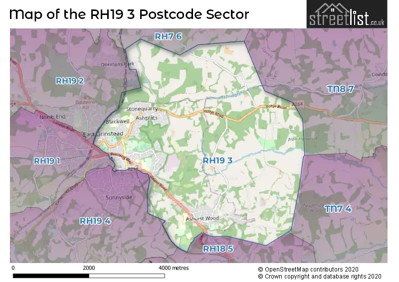
The RH19 3 Postcode shares a border with RH19 1 (EAST GRINSTEAD), RH7 6 (LINGFIELD, Dormansland, Newchapel), RH18 5 (FOREST ROW, Wych Cross, Weir Wood), RH19 2 (EAST GRINSTEAD, Felbridge, Felcourt), RH19 4 (EAST GRINSTEAD, Sharpthorne, West Hoathly), TN7 4 (HARTFIELD, Withyham, Upper Hartfield) and TN8 7 (Cowden, Hever, Chiddingstone).
The sector is within the post town of EAST GRINSTEAD.
RH19 3 is a postcode sector within the RH19 postcode district which is within the RH Redhill postcode area.
The Royal Mail delivery office for the RH19 3 postal sector is the East Grinstead Delivery Office.
The area of the RH19 3 postcode sector is 8.23 square miles which is 21.30 square kilometres or 5,264.57 square acres.
Waterways within the RH19 3 postcode sector include the Kent Water.

Map of the RH19 3 Postcode Sector
Explore the RH19 3 postcode sector by using our free interactive map.
| R | H | 1 | 9 | - | 3 | X | X |
| R | H | 1 | 9 | Space | 3 | Letter | Letter |
Official List of Streets
Ashurst Wood (22 Streets)
EAST GRINSTEAD (124 Streets)
Hammerwood (1 Streets)
Dormans Park (1 Streets)
Unofficial Streets or Alternative Spellings
Cowden
HOLTYE ROAD SMITHERS LANE BADGERS WALK BEECH FIELDS BEECH WALK BEECHING WAY BLACKWELL HOLLOW BLACKWELL HOLLOW ROUNDABOUT BLUEBELLS BORDER COURT BOURG-DE-PEAGE AVENUE BOX LANE CANTELUPE MEWS CHESTNUT WALK COPPICE RIDE COPSE WOOD CRICKET COURT FAIRLIGHT RIDE FOREST WAY FORGE TWITTEN GASHOUSE LANE GHYLL SLOPE GUINEA PIG PLACE HAMMERWOOD HOLCROFT COURT HOLLIES HOLTYE TRACK JUDGES CLOSE JUDGES TERRACE KINGS MEWS MAIN TRACK MCINDOE WALK MOONS LANE NORTH DRIVE OWL WAY OWLETTS LANE PEGASUS PATH PINE PATH SHEPHERDSGROVE LANE SHOVELSTRODE ROAD (TRACK) STROUDLEY COURT TALL TREES TUDOR COURT WELLFIELD WOOD AVENUEDormansland
HOLLOW LANEEAST GRINSTEAD
FAIRFIELD ROAD GLENDYNE WAY HERMITAGE LANE HERONTYE DRIVE PORTLAND ROAD ST. JOHNS CLOSEDormans Park
WILDERNESS RISEFelbridge
LONDON ROADFOREST ROW
LONDON ROAD WALL HILLWeather Forecast for RH19 3
Press Button to Show Forecast for East Grinstead
| Time Period | Icon | Description | Temperature | Rain Probability | Wind |
|---|---|---|---|---|---|
| 03:00 to 06:00 | Light rain | 6.0°C (feels like 3.0°C) | 59.00% | ENE 9 mph | |
| 06:00 to 09:00 | Drizzle | 7.0°C (feels like 4.0°C) | 27.00% | ENE 9 mph | |
| 09:00 to 12:00 | Overcast | 9.0°C (feels like 7.0°C) | 18.00% | ENE 9 mph | |
| 12:00 to 15:00 | Cloudy | 12.0°C (feels like 10.0°C) | 36.00% | E 7 mph | |
| 15:00 to 18:00 | Cloudy | 12.0°C (feels like 10.0°C) | 49.00% | E 9 mph | |
| 18:00 to 21:00 | Light rain | 10.0°C (feels like 8.0°C) | 84.00% | NE 9 mph | |
| 21:00 to 00:00 | Heavy rain | 9.0°C (feels like 6.0°C) | 91.00% | NE 11 mph |
Press Button to Show Forecast for East Grinstead
| Time Period | Icon | Description | Temperature | Rain Probability | Wind |
|---|---|---|---|---|---|
| 00:00 to 03:00 | Heavy rain | 9.0°C (feels like 7.0°C) | 93.00% | NE 9 mph | |
| 03:00 to 06:00 | Heavy rain | 9.0°C (feels like 7.0°C) | 87.00% | ENE 9 mph | |
| 06:00 to 09:00 | Light rain | 9.0°C (feels like 7.0°C) | 55.00% | SSW 9 mph | |
| 09:00 to 12:00 | Heavy rain | 9.0°C (feels like 6.0°C) | 79.00% | WNW 11 mph | |
| 12:00 to 15:00 | Light rain | 9.0°C (feels like 6.0°C) | 50.00% | WSW 13 mph | |
| 15:00 to 18:00 | Cloudy | 10.0°C (feels like 7.0°C) | 13.00% | WSW 11 mph | |
| 18:00 to 21:00 | Cloudy | 9.0°C (feels like 8.0°C) | 15.00% | WSW 9 mph | |
| 21:00 to 00:00 | Clear night | 7.0°C (feels like 5.0°C) | 3.00% | S 7 mph |
Press Button to Show Forecast for East Grinstead
| Time Period | Icon | Description | Temperature | Rain Probability | Wind |
|---|---|---|---|---|---|
| 00:00 to 03:00 | Clear night | 6.0°C (feels like 4.0°C) | 1.00% | SW 4 mph | |
| 03:00 to 06:00 | Clear night | 5.0°C (feels like 3.0°C) | 1.00% | S 4 mph | |
| 06:00 to 09:00 | Sunny day | 7.0°C (feels like 5.0°C) | 1.00% | S 4 mph | |
| 09:00 to 12:00 | Partly cloudy (day) | 11.0°C (feels like 9.0°C) | 2.00% | S 9 mph | |
| 12:00 to 15:00 | Sunny day | 13.0°C (feels like 11.0°C) | 2.00% | S 11 mph | |
| 15:00 to 18:00 | Partly cloudy (day) | 13.0°C (feels like 11.0°C) | 4.00% | S 11 mph | |
| 18:00 to 21:00 | Sunny day | 12.0°C (feels like 11.0°C) | 3.00% | S 7 mph | |
| 21:00 to 00:00 | Clear night | 8.0°C (feels like 6.0°C) | 1.00% | SE 7 mph |
Press Button to Show Forecast for East Grinstead
| Time Period | Icon | Description | Temperature | Rain Probability | Wind |
|---|---|---|---|---|---|
| 00:00 to 03:00 | Clear night | 8.0°C (feels like 6.0°C) | 2.00% | ESE 7 mph | |
| 03:00 to 06:00 | Clear night | 7.0°C (feels like 5.0°C) | 3.00% | ESE 7 mph | |
| 06:00 to 09:00 | Mist | 9.0°C (feels like 7.0°C) | 18.00% | ESE 7 mph | |
| 09:00 to 12:00 | Partly cloudy (day) | 13.0°C (feels like 11.0°C) | 3.00% | SE 9 mph | |
| 12:00 to 15:00 | Cloudy | 15.0°C (feels like 13.0°C) | 8.00% | SE 11 mph | |
| 15:00 to 18:00 | Cloudy | 15.0°C (feels like 13.0°C) | 8.00% | SE 9 mph | |
| 18:00 to 21:00 | Cloudy | 14.0°C (feels like 12.0°C) | 11.00% | SE 7 mph | |
| 21:00 to 00:00 | Cloudy | 11.0°C (feels like 10.0°C) | 10.00% | ESE 7 mph |
Schools and Places of Education Within the RH19 3 Postcode Sector
Ashurst Wood Primary School
Community school
School Lane, East Grinstead, West Sussex, RH19 3QW
Head: Mrs Lisa Hobby
Ofsted Rating: Requires improvement
Inspection: 2023-03-14 (410 days ago)
Website: Visit Ashurst Wood Primary School Website
Phone: 01342822584
Number of Pupils: 136
Blackwell Primary School
Academy sponsor led
Blackwell Farm Road, East Grinstead, West Sussex, RH19 3JL
Head: Mrs Sarah Martin
Ofsted Rating: Good
Inspection: 2023-05-24 (339 days ago)
Website: Visit Blackwell Primary School Website
Phone: 01342323906
Number of Pupils: 346
Estcots Primary School
Community school
Bourg-De-Peage Avenue, East Grinstead, West Sussex, RH19 3TY
Head: Mrs Rachel Brock
Ofsted Rating: Good
Inspection: 2019-07-16 (1747 days ago)
Website: Visit Estcots Primary School Website
Phone: 01342327473
Number of Pupils: 419
Sackville School
Community school
Lewes Road, East Grinstead, West Sussex, RH19 3TY
Head: Ms Jo Meloni
Ofsted Rating: Good
Inspection: 2019-01-10 (1934 days ago)
Website: Visit Sackville School Website
Phone: 01342410140
Number of Pupils: 1719
House Prices in the RH19 3 Postcode Sector
| Type of Property | 2018 Average | 2018 Sales | 2017 Average | 2017 Sales | 2016 Average | 2016 Sales | 2015 Average | 2015 Sales |
|---|---|---|---|---|---|---|---|---|
| Detached | £576,028 | 54 | £507,917 | 43 | £518,128 | 69 | £526,455 | 69 |
| Semi-Detached | £405,857 | 35 | £383,800 | 35 | £390,325 | 52 | £366,058 | 51 |
| Terraced | £306,408 | 61 | £317,439 | 57 | £359,393 | 120 | £297,821 | 81 |
| Flats | £226,191 | 123 | £221,065 | 79 | £245,743 | 68 | £215,334 | 72 |
Important Postcodes RH19 3 in the Postcode Sector
RH19 3AA is the postcode for Doctors Surgery, Judges Terrace, High Street
RH19 3BE is the postcode for Health & Safety Executive, Phoenix House, 23-25 Cantelupe Road
RH19 3DZ is the postcode for PEANUT WARD, Queen Victoria Hospital NHS Trust, Holtye Road, NEW THEATRE BUILDING, Queen Victoria Hospital NHS Trust, Holtye Road, CANADIAN WING, Queen Victoria Hospital NHS Trust, Holtye Road, Canadian Wing, Queen Victoria Hospital, Holtye Road, BURNS CENTRE, Queen Victoria Hospital NHS Trust, Holtye Road, Queen Victoria Hospital NHS Foundation Trust, Queen Victoria Hospital (rpc), BLOND MCINDOE RESEARCH (BMR), Queen Victoria Hospital NHS Trust, Holtye Road, American Wing, Queen Victoria Hospital, Holtye Road, AMERICAN WING, Queen Victoria Hospital NHS Trust, Holtye Road, MAXILLO FACIAL & OPD, Queen Victoria Hospital NHS Trust, Holtye Road, MAXILLO FACIAL, Queen Victoria Hospital NHS Trust, Holtye Road, REHAB UNIT, Queen Victoria Hospital NHS Trust, Holtye Road, GENERAL HOSPITAL, Queen Victoria Hospital NHS Trust, Holtye Road, and MAIN OUTPATIENTS DEPARTMENT, Queen Victoria Hospital NHS Trust, Holtye Road
RH19 3EB is the postcode for The McIndoe Centre, Holtye Road
RH19 3GW is the postcode for Moatfield Surgery, St. Michaels Road
RH19 3JL is the postcode for Blackwell Primary School, Blackwell Farm Road
RH19 3JS is the postcode for East Grinstead Health Clinic, St Michaels Road, and East Grinstead Health Centre, St. Michaels Road
RH19 3LH is the postcode for 72-74 Moat Road
RH19 3LN is the postcode for Places for People Leisure Management Ltd, The Kings Centre, Moat Road, Mid Sussex District Council, Olympos, and The Kings Centre, Moat Road
RH19 3LS is the postcode for The Old Court House, College Lane
RH19 3LT is the postcode for East Grinstead Town Council, Council Offices, College Lane, East Court, and MERIDIAN HALL, East Grinstead Town Council, Council Offices, College Lane, East Court
RH19 3LX is the postcode for Police Station, East Court, College Lane
RH19 3QW is the postcode for Ashurst Wood Primary School, School Lane
RH19 3TY is the postcode for Estcots Primary School, Lewes Road, TECHNOLOGY BLOCK, Sackville School, Lewes Road, Sackville School, Lewes Road, ENGLISH BLOCK, Sackville School, Lewes Road, MUSIC BLOCK, Sackville School, Lewes Road, MATHS BLOCK, Sackville School, Lewes Road, SPORTS CENTRE, Sackville School, Lewes Road, and MAIN BUILDING, Sackville School, Lewes Road
| The RH19 3 Sector is within these Local Authorities |
|
|---|---|
| The RH19 3 Sector is within these Counties |
|
| The RH19 3 Sector is within these Water Company Areas |
|