The RH8 postcode district is a postal district located in the RH Redhill postcode area with a population of 15,852 residents according to the 2021 England and Wales Census.
The area of the RH8 postcode district is 14.57 square miles which is 37.73 square kilometres or 9,323.91 acres.
Currently, the RH8 district has about 396 postcode units spread across 2 geographic postcode sectors.
Given that each sector allows for 400 unique postcode combinations, the district has a capacity of 800 postcodes. With 396 postcodes already in use, this leaves 404 units available.
The largest settlement in the RH8 postal code is OXTED followed by HURST GREEN, and LIMPSFIELD.
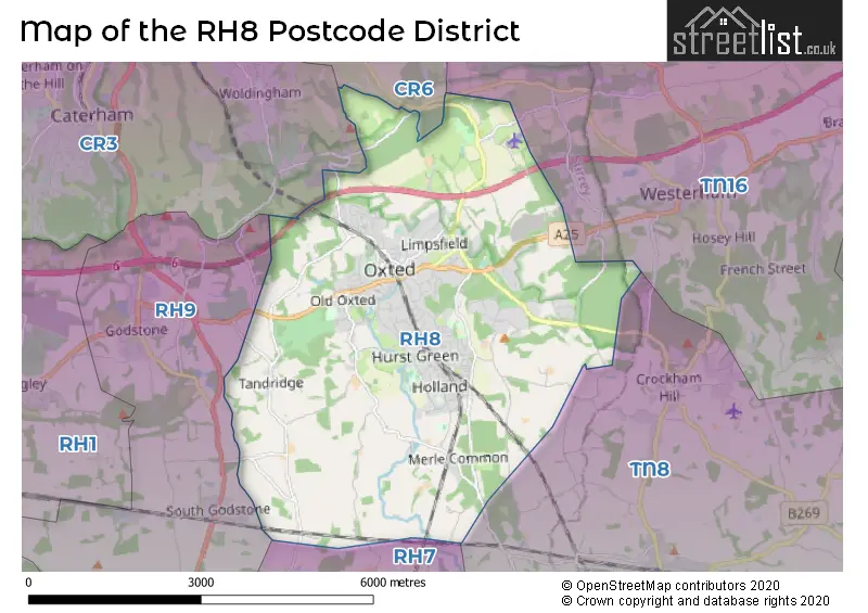
The RH8 Postcode shares a border with TN8 (EDENBRIDGE, Cowden, Hever), RH7 (LINGFIELD, Dormansland, Newchapel), CR3 (CATERHAM, WHYTELEAFE), CR6 (WARLINGHAM) and RH9 (GODSTONE, South Godstone).
The primary settlement in the RH8 postcode district is OXTED, located in the county of Surrey, England. Other significant settlements in the district include Limpsfield, Limpsfield Chart, and Titsey. The most significant post town in the district is OXTED.
For the district RH8, we have data on 3 postcode sectors. Here's a breakdown: The sector RH8 0, covers Oxted in Surrey. The sector RH8 8 is non-geographic. It's often designated for PO Boxes, large organisations, or special services. The sector RH8 9, covers Oxted in Surrey.

Map of the RH8 Postcode District
Explore the RH8 postcode district by using our free interactive map.
When it comes to local government, postal geography often disregards political borders. However, for a breakdown in the RH8 District: the district mostly encompasses the Tandridge District area with a total of 415 postcodes.
Recent House Sales in RH8
| Date | Price | Address |
|---|---|---|
| 24/10/2023 | £230,000 | High Street, Oxted, RH8 9LN |
| 16/10/2023 | £760,000 | Ridlands Rise, Oxted, RH8 0TT |
| 28/09/2023 | £440,000 | Station Road West, Oxted, RH8 9EB |
| 14/09/2023 | £500,000 | Johnsdale, Oxted, RH8 0BP |
| 04/09/2023 | £975,000 | High Street, Limpsfield, Oxted, RH8 0DY |
| 01/09/2023 | £300,000 | Church Lane, Oxted, RH8 9LH |
| 30/08/2023 | £575,000 | Hurstlands, Oxted, RH8 0HF |
| 23/08/2023 | £570,000 | Chestnut Copse, Oxted, RH8 0JJ |
| 22/08/2023 | £5,175,000 | Trevereux Hill, Oxted, RH8 0TL |
| 18/08/2023 | £300,000 | Southlands Lane, Tandridge, Oxted, RH8 9PH |
Weather Forecast for RH8
Press Button to Show Forecast for Oxted
| Time Period | Icon | Description | Temperature | Rain Probability | Wind |
|---|---|---|---|---|---|
| 18:00 to 21:00 | Cloudy | 9.0°C (feels like 7.0°C) | 6.00% | ESE 9 mph | |
| 21:00 to 00:00 | Cloudy | 7.0°C (feels like 5.0°C) | 11.00% | E 9 mph |
Press Button to Show Forecast for Oxted
| Time Period | Icon | Description | Temperature | Rain Probability | Wind |
|---|---|---|---|---|---|
| 00:00 to 03:00 | Heavy rain | 7.0°C (feels like 4.0°C) | 79.00% | ENE 9 mph | |
| 03:00 to 06:00 | Light rain | 6.0°C (feels like 3.0°C) | 57.00% | NE 11 mph | |
| 06:00 to 09:00 | Overcast | 7.0°C (feels like 4.0°C) | 18.00% | NE 9 mph | |
| 09:00 to 12:00 | Overcast | 9.0°C (feels like 7.0°C) | 13.00% | ENE 9 mph | |
| 12:00 to 15:00 | Cloudy | 12.0°C (feels like 10.0°C) | 32.00% | NE 9 mph | |
| 15:00 to 18:00 | Cloudy | 12.0°C (feels like 10.0°C) | 50.00% | ENE 9 mph | |
| 18:00 to 21:00 | Light rain | 10.0°C (feels like 8.0°C) | 88.00% | NE 9 mph | |
| 21:00 to 00:00 | Heavy rain | 9.0°C (feels like 7.0°C) | 91.00% | NE 11 mph |
Press Button to Show Forecast for Oxted
| Time Period | Icon | Description | Temperature | Rain Probability | Wind |
|---|---|---|---|---|---|
| 00:00 to 03:00 | Heavy rain | 9.0°C (feels like 7.0°C) | 92.00% | NNE 9 mph | |
| 03:00 to 06:00 | Heavy rain | 9.0°C (feels like 7.0°C) | 86.00% | ENE 9 mph | |
| 06:00 to 09:00 | Heavy rain | 9.0°C (feels like 7.0°C) | 86.00% | ESE 7 mph | |
| 09:00 to 12:00 | Light rain | 9.0°C (feels like 7.0°C) | 52.00% | W 11 mph | |
| 12:00 to 15:00 | Light rain | 9.0°C (feels like 6.0°C) | 57.00% | W 13 mph | |
| 15:00 to 18:00 | Cloudy | 10.0°C (feels like 7.0°C) | 15.00% | W 11 mph | |
| 18:00 to 21:00 | Cloudy | 10.0°C (feels like 8.0°C) | 15.00% | WSW 9 mph | |
| 21:00 to 00:00 | Clear night | 7.0°C (feels like 6.0°C) | 3.00% | SW 7 mph |
Press Button to Show Forecast for Oxted
| Time Period | Icon | Description | Temperature | Rain Probability | Wind |
|---|---|---|---|---|---|
| 00:00 to 03:00 | Clear night | 6.0°C (feels like 4.0°C) | 1.00% | SSW 4 mph | |
| 03:00 to 06:00 | Clear night | 5.0°C (feels like 3.0°C) | 2.00% | S 4 mph | |
| 06:00 to 09:00 | Sunny day | 7.0°C (feels like 5.0°C) | 1.00% | S 4 mph | |
| 09:00 to 12:00 | Partly cloudy (day) | 11.0°C (feels like 9.0°C) | 3.00% | S 9 mph | |
| 12:00 to 15:00 | Partly cloudy (day) | 14.0°C (feels like 11.0°C) | 3.00% | S 11 mph | |
| 15:00 to 18:00 | Partly cloudy (day) | 14.0°C (feels like 11.0°C) | 2.00% | S 11 mph | |
| 18:00 to 21:00 | Sunny day | 12.0°C (feels like 11.0°C) | 3.00% | S 7 mph | |
| 21:00 to 00:00 | Clear night | 9.0°C (feels like 7.0°C) | 1.00% | SE 7 mph |
Press Button to Show Forecast for Oxted
| Time Period | Icon | Description | Temperature | Rain Probability | Wind |
|---|---|---|---|---|---|
| 00:00 to 03:00 | Clear night | 8.0°C (feels like 6.0°C) | 1.00% | ESE 7 mph | |
| 03:00 to 06:00 | Clear night | 8.0°C (feels like 6.0°C) | 3.00% | ESE 7 mph | |
| 06:00 to 09:00 | Partly cloudy (day) | 9.0°C (feels like 7.0°C) | 6.00% | ESE 7 mph | |
| 09:00 to 12:00 | Cloudy | 13.0°C (feels like 12.0°C) | 6.00% | SE 9 mph | |
| 12:00 to 15:00 | Cloudy | 15.0°C (feels like 13.0°C) | 9.00% | SE 9 mph | |
| 15:00 to 18:00 | Cloudy | 16.0°C (feels like 14.0°C) | 9.00% | SE 9 mph | |
| 18:00 to 21:00 | Cloudy | 14.0°C (feels like 13.0°C) | 10.00% | SE 7 mph | |
| 21:00 to 00:00 | Cloudy | 12.0°C (feels like 11.0°C) | 9.00% | ESE 7 mph |
Where is the RH8 Postcode District?
The RH8 postcode district is located in Oxted, which is a town in the South East. Oxted is surrounded by several nearby towns, including Hurst Green to the South East, Limpsfield to the East, Tandridge to the South West, Titsey to the North, Godstone to the West, Westerham to the North East, and Woldingham to the North West. Additionally, Oxted is approximately 18.87 miles away from the center of London.
The district is within the post town of OXTED.
The sector has postcodes within the nation of England.
The RH8 Postcode District is in the East Surrey region of Surrey, East and West Sussex within the South East (England).
| Postcode Sector | Delivery Office |
|---|---|
| RH8 0 | Oxted Delivery Office |
| RH8 9 | Oxted Delivery Office |
| R | H | 8 | - | X | X | X |
| R | H | 8 | Space | Numeric | Letter | Letter |
Current Monthly Rental Prices
| # Bedrooms | Min Price | Max Price | Avg Price |
|---|---|---|---|
| 1 | £1,100 | £1,300 | £1,233 |
| 2 | £1,700 | £1,700 | £1,700 |
| 3 | £1,950 | £3,000 | £2,588 |
Current House Prices
| # Bedrooms | Min Price | Max Price | Avg Price |
|---|---|---|---|
| 1 | £210,000 | £479,950 | £270,905 |
| 2 | £250,000 | £1,200,000 | £497,847 |
| 3 | £450,000 | £1,100,000 | £695,266 |
| 4 | £600,000 | £2,450,000 | £1,189,737 |
| 5 | £750,000 | £3,500,000 | £1,740,313 |
| 6 | £2,350,000 | £4,200,000 | £3,206,250 |
| 7 | £2,500,000 | £2,500,000 | £2,500,000 |
| 9 | £4,500,000 | £4,500,000 | £4,500,000 |
Estate Agents who Operate in the RH8 District
| Logo | Name | Brand Name | Address | Contact Number | Total Properties |
|---|---|---|---|---|---|
 | Oxted | Robert Leech Estate Agents | 72 Station Road East, Oxted, RH8 0PG | 01883 779596 | 32 |
 | Oxted | Jackson-Stops | 17-19 Station Road West, Oxted, RH8 9EE | 01883 771063 | 22 |
 | Oxted | Payne & Co | 11 Station Road West, Oxted, RH8 9EE | 01883 712261 | 22 |
 | Oxted | White & Sons | 39-41 Station Road East, Oxted, RH8 0BD | 01883 771082 | 13 |
 | Covering Kent/Surrey | Platform Property | The Dairy Swan Lane Farm, Edenbridge, TN8 6AL | 01732 444125 | 8 |
| Type of Property | 2018 Average | 2018 Sales | 2017 Average | 2017 Sales | 2016 Average | 2016 Sales | 2015 Average | 2015 Sales |
|---|---|---|---|---|---|---|---|---|
| Detached | £954,279 | 80 | £903,193 | 83 | £839,497 | 93 | £927,452 | 103 |
| Semi-Detached | £517,357 | 42 | £517,032 | 71 | £493,273 | 64 | £547,733 | 56 |
| Terraced | £372,256 | 31 | £418,950 | 49 | £401,371 | 75 | £388,237 | 92 |
| Flats | £362,427 | 40 | £371,893 | 48 | £328,332 | 71 | £340,940 | 61 |