The S25 4 postcode sector is within the county of South Yorkshire.
Did you know? According to the 2021 Census, the S25 4 postcode sector is home to a bustling 6,427 residents!
Given that each sector allows for 400 unique postcode combinations. Letters C, I, K, M, O and V are not allowed in the last two letters of a postcode. With 125 postcodes already in use, this leaves 275 units available.
The S25 4 postal code covers the settlement of North Anston.
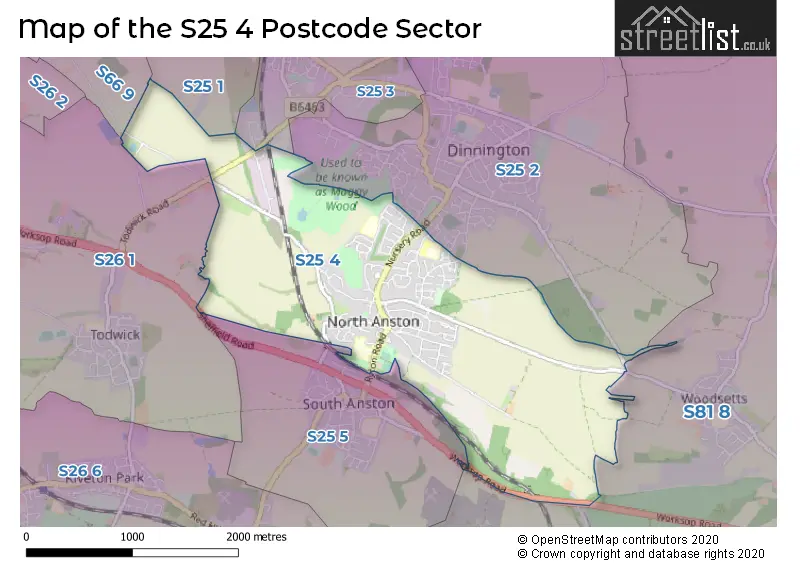
The S25 4 Postcode shares a border with S25 1 (Laughton), S25 3 (Dinnington), S25 5 (South Anston), S26 1 (Todwick), S66 9 (Thurcroft, Brampton-en-le-Morthen, Morthen), S25 2 (Dinnington) and S81 8 (Shireoaks, Gateford, Blyth).
The sector is within the post town of SHEFFIELD.
S25 4 is a postcode sector within the S25 postcode district which is within the S Sheffield postcode area.
The Royal Mail delivery office for the S25 4 postal sector is the Dinnington Delivery Office.
The area of the S25 4 postcode sector is 2.68 square miles which is 6.93 square kilometres or 1,712.73 square acres.
Waterways within the S25 4 postcode sector include the Anston Brook.

Map of the S25 4 Postcode Sector
Explore the S25 4 postcode sector by using our free interactive map.
| S | 2 | 5 | - | 4 | X | X |
| S | 2 | 5 | Space | 4 | Letter | Letter |
Official List of Streets
North Anston (100 Streets)
Anston (3 Streets)
Unofficial Streets or Alternative Spellings
Dinnington
BEECH GROVE BOOKERS WAY BORROWDALE CRESCENT FALCON WAY KINGFISHER WAY NURSERY ROAD PARK AVENUE SWINSTON HILL ROADSouth Anston
MILL LANE SHEFFIELD ROAD WORKSOP ROADAston
TODWICK ROADThurcroft
LONG ROADSchools and Places of Education Within the S25 4 Postcode Sector
Anston Brook Primary School
Academy converter
Ryton Road, Sheffield, South Yorkshire, S25 4DN
Head: Miss Sally Armstrong
Ofsted Rating: Good
Inspection: 2021-09-22 (974 days ago)
Website: Visit Anston Brook Primary School Website
Phone: 01909550599
Number of Pupils: 184
Anston Greenlands Primary School
Academy converter
Edinburgh Drive, Sheffield, South Yorkshire, S25 4HD
Head: Mr Alex Wirth
Ofsted Rating: Good
Inspection: 2023-02-22 (456 days ago)
Website: Visit Anston Greenlands Primary School Website
Phone: 01909550557
Number of Pupils: 212
House Prices in the S25 4 Postcode Sector
| Type of Property | 2018 Average | 2018 Sales | 2017 Average | 2017 Sales | 2016 Average | 2016 Sales | 2015 Average | 2015 Sales |
|---|---|---|---|---|---|---|---|---|
| Detached | £245,420 | 29 | £215,389 | 18 | £206,148 | 27 | £235,200 | 31 |
| Semi-Detached | £128,522 | 49 | £132,239 | 46 | £122,296 | 48 | £122,992 | 56 |
| Terraced | £103,036 | 7 | £109,143 | 14 | £168,250 | 10 | £114,924 | 15 |
| Flats | £0 | 0 | £49,030 | 1 | £0 | 0 | £40,000 | 1 |
Important Postcodes S25 4 in the Postcode Sector
S25 4AA is the postcode for Royal Mail, Dinnington Delivery Office, Houghton Road
S25 4DN is the postcode for Anston Brook Primary School, Ryton Road, and Anston Brook Primary School, Ryton Road, North Anston
S25 4HD is the postcode for Anston Greenlands Junior & Infant School, Edinburgh Drive, North Anston, and Anston Greenlands Junior & Infant School, Edinburgh Drive
| The S25 4 Sector is within these Local Authorities |
|
|---|---|
| The S25 4 Sector is within these Counties |
|
| The S25 4 Sector is within these Water Company Areas |
|
Tourist Attractions within the S25 4 Postcode Area
We found 1 visitor attractions within the S25 postcode area
| Tropical Butterfly House |
|---|
| Wildlife |
| Safari Park / Zoo / Aquarium / Aviary |
| View Tropical Butterfly House on Google Maps |