The S33 0 postcode sector stands on the Derbyshire and South Yorkshire border.
Did you know? According to the 2021 Census, the S33 0 postcode sector is home to a bustling 1,442 residents!
Given that each sector allows for 400 unique postcode combinations. Letters C, I, K, M, O and V are not allowed in the last two letters of a postcode. With 46 postcodes already in use, this leaves 354 units available.
The S33 0 postal code covers the settlement of Bamford.
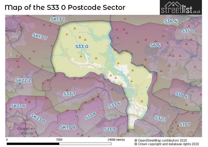
The S33 0 Postcode shares a border with SK13 7 (GLOSSOP), SK13 1 (Hadfield, Tintwistle, Padfield), S6 6 (Stannington, Loxley, Bradfield), S32 1 (Hathersage), S33 6 (Hope), S33 7 (Edale) and S33 9 (Bradwell).
The sector is within the post town of HOPE VALLEY.
S33 0 is a postcode sector within the S33 postcode district which is within the S Sheffield postcode area.
The Royal Mail delivery office for the S33 0 postal sector is the Bamford Scale Payment Delivery Office.
The area of the S33 0 postcode sector is 34.08 square miles which is 88.26 square kilometres or 21,808.51 square acres.
Waterways within the S33 0 postcode sector include the Derwent, River Noe, River Derwent, River Ashop, River Alport, Black Clough, Fair Brook, Blackden Brook, Ladybower Brook, River Westend, Lady Clough, Jarvis Clough, Deep Grain, Grinah Grain, Back Dike, Rising Clough, Dovestone Clough, Far Deep Clough, Mill Brook, Swint Clough, Highshaw Clough.

Map of the S33 0 Postcode Sector
Explore the S33 0 postcode sector by using our free interactive map.
| S | 3 | 3 | - | 0 | X | X |
| S | 3 | 3 | Space | 0 | Letter | Letter |
Official List of Streets
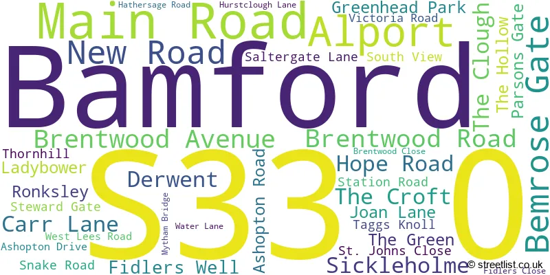
Bamford (37 Streets)
Unofficial Streets or Alternative Spellings
Penistone
MORTIMER ROADRivelin
MANCHESTER ROADHathersage
CASTLETON ROADWeather Forecast for S33 0
Press Button to Show Forecast for Derwent Valley
| Time Period | Icon | Description | Temperature | Rain Probability | Wind |
|---|---|---|---|---|---|
| 09:00 to 12:00 | Heavy rain | 4.0°C (feels like 0.0°C) | 94.00% | NNW 11 mph | |
| 12:00 to 15:00 | Heavy rain | 5.0°C (feels like 2.0°C) | 85.00% | NW 11 mph | |
| 15:00 to 18:00 | Light rain | 7.0°C (feels like 3.0°C) | 55.00% | W 13 mph | |
| 18:00 to 21:00 | Partly cloudy (day) | 7.0°C (feels like 4.0°C) | 14.00% | W 11 mph | |
| 21:00 to 00:00 | Clear night | 4.0°C (feels like 2.0°C) | 3.00% | SW 7 mph |
Press Button to Show Forecast for Derwent Valley
| Time Period | Icon | Description | Temperature | Rain Probability | Wind |
|---|---|---|---|---|---|
| 00:00 to 03:00 | Clear night | 4.0°C (feels like 1.0°C) | 2.00% | SW 11 mph | |
| 03:00 to 06:00 | Clear night | 4.0°C (feels like 0.0°C) | 8.00% | SW 11 mph | |
| 06:00 to 09:00 | Cloudy | 6.0°C (feels like 2.0°C) | 39.00% | SSW 11 mph | |
| 09:00 to 12:00 | Cloudy | 9.0°C (feels like 6.0°C) | 37.00% | SSW 16 mph | |
| 12:00 to 15:00 | Overcast | 11.0°C (feels like 8.0°C) | 15.00% | SSW 16 mph | |
| 15:00 to 18:00 | Light rain shower (day) | 11.0°C (feels like 8.0°C) | 32.00% | S 18 mph | |
| 18:00 to 21:00 | Cloudy | 11.0°C (feels like 8.0°C) | 11.00% | S 13 mph | |
| 21:00 to 00:00 | Cloudy | 9.0°C (feels like 6.0°C) | 7.00% | S 13 mph |
Press Button to Show Forecast for Derwent Valley
| Time Period | Icon | Description | Temperature | Rain Probability | Wind |
|---|---|---|---|---|---|
| 00:00 to 03:00 | Partly cloudy (night) | 7.0°C (feels like 4.0°C) | 3.00% | S 11 mph | |
| 03:00 to 06:00 | Partly cloudy (night) | 6.0°C (feels like 3.0°C) | 3.00% | SSE 9 mph | |
| 06:00 to 09:00 | Partly cloudy (day) | 7.0°C (feels like 4.0°C) | 2.00% | SE 11 mph | |
| 09:00 to 12:00 | Sunny day | 11.0°C (feels like 9.0°C) | 1.00% | SE 11 mph | |
| 12:00 to 15:00 | Cloudy | 14.0°C (feels like 11.0°C) | 7.00% | SE 16 mph | |
| 15:00 to 18:00 | Light rain shower (day) | 14.0°C (feels like 11.0°C) | 33.00% | SE 13 mph | |
| 18:00 to 21:00 | Partly cloudy (day) | 13.0°C (feels like 11.0°C) | 13.00% | SE 9 mph | |
| 21:00 to 00:00 | Partly cloudy (night) | 10.0°C (feels like 9.0°C) | 11.00% | ESE 7 mph |
Press Button to Show Forecast for Derwent Valley
| Time Period | Icon | Description | Temperature | Rain Probability | Wind |
|---|---|---|---|---|---|
| 00:00 to 03:00 | Cloudy | 9.0°C (feels like 8.0°C) | 14.00% | SE 4 mph | |
| 03:00 to 06:00 | Cloudy | 8.0°C (feels like 7.0°C) | 18.00% | SE 4 mph | |
| 06:00 to 09:00 | Cloudy | 9.0°C (feels like 9.0°C) | 16.00% | NNE 2 mph | |
| 09:00 to 12:00 | Cloudy | 11.0°C (feels like 10.0°C) | 15.00% | ENE 4 mph | |
| 12:00 to 15:00 | Cloudy | 14.0°C (feels like 13.0°C) | 15.00% | ENE 7 mph | |
| 15:00 to 18:00 | Cloudy | 15.0°C (feels like 14.0°C) | 15.00% | ENE 7 mph | |
| 18:00 to 21:00 | Cloudy | 13.0°C (feels like 12.0°C) | 13.00% | ENE 9 mph | |
| 21:00 to 00:00 | Light rain | 11.0°C (feels like 9.0°C) | 42.00% | NE 9 mph |
Schools and Places of Education Within the S33 0 Postcode Sector
Bamford Primary School
Community school
Fidlers Well, Hope Valley, Derbyshire, S33 0AR
Head: Mrs Kate Gemmell
Ofsted Rating: Good
Inspection: 2022-04-27 (732 days ago)
Website: Visit Bamford Primary School Website
Phone: 01433651267
Number of Pupils: 69
House Prices in the S33 0 Postcode Sector
| Type of Property | 2018 Average | 2018 Sales | 2017 Average | 2017 Sales | 2016 Average | 2016 Sales | 2015 Average | 2015 Sales |
|---|---|---|---|---|---|---|---|---|
| Detached | £531,786 | 7 | £388,750 | 8 | £484,993 | 7 | £569,286 | 7 |
| Semi-Detached | £274,724 | 9 | £306,667 | 6 | £327,111 | 9 | £222,667 | 3 |
| Terraced | £217,500 | 13 | £230,675 | 8 | £231,743 | 7 | £185,000 | 6 |
| Flats | £207,833 | 6 | £249,590 | 5 | £228,750 | 3 | £220,750 | 4 |
Important Postcodes S33 0 in the Postcode Sector
S33 0AR is the postcode for INFANT SITE, Bamford Primary School, Fidlers Well, and JUNIOR SITE, Bamford Primary School, Fidlers Well
S33 0BJ is the postcode for Hagg Farm Outdoor Education Centre, Snake Road
| The S33 0 Sector is within these Local Authorities |
|
|---|---|
| The S33 0 Sector is within these Counties |
|
| The S33 0 Sector is within these Water Company Areas |
|