The S33 7 postcode sector is within the county of Derbyshire.
Did you know? According to the 2021 Census, the S33 7 postcode sector is home to a bustling 286 residents!
Given that each sector allows for 400 unique postcode combinations. Letters C, I, K, M, O and V are not allowed in the last two letters of a postcode. With 12 postcodes already in use, this leaves 388 units available.
The S33 7 postal code covers the settlement of Edale.
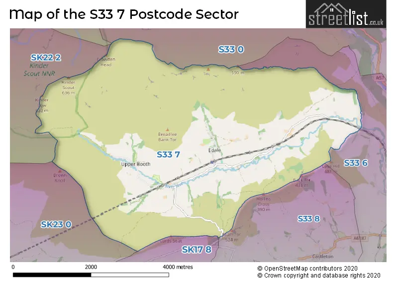
The S33 7 Postcode shares a border with SK13 7 (GLOSSOP), SK22 2 (Hayfield, Little Hayfield), SK23 0 (Chapel-en-le-Frith), S33 0 (Bamford), S33 6 (Hope), S33 8 (Castleton) and SK17 8 (Tideswell, Dove Holes, Peak Dale).
The sector is within the post town of HOPE VALLEY.
S33 7 is a postcode sector within the S33 postcode district which is within the S Sheffield postcode area.
The Royal Mail delivery office for the S33 7 postal sector is the Hope Scale Payment Delivery Office.
The area of the S33 7 postcode sector is 11.00 square miles which is 28.48 square kilometres or 7,038.32 square acres.
Waterways within the S33 7 postcode sector include the River Noe, Grinds Brook, Jaggers Clough, Crowden Brook.

Map of the S33 7 Postcode Sector
Explore the S33 7 postcode sector by using our free interactive map.
| S | 3 | 3 | - | 7 | X | X |
| S | 3 | 3 | Space | 7 | Letter | Letter |
Official List of Streets
Unofficial Streets or Alternative Spellings
Weather Forecast for S33 7
Press Button to Show Forecast for Edale Moorland Centre
| Time Period | Icon | Description | Temperature | Rain Probability | Wind |
|---|---|---|---|---|---|
| 06:00 to 09:00 | Heavy rain | 4.0°C (feels like 0.0°C) | 91.00% | NNE 13 mph | |
| 09:00 to 12:00 | Heavy rain | 4.0°C (feels like 1.0°C) | 91.00% | NNW 11 mph | |
| 12:00 to 15:00 | Heavy rain | 5.0°C (feels like 2.0°C) | 84.00% | NW 11 mph | |
| 15:00 to 18:00 | Heavy rain | 7.0°C (feels like 3.0°C) | 79.00% | W 13 mph | |
| 18:00 to 21:00 | Partly cloudy (day) | 7.0°C (feels like 4.0°C) | 10.00% | W 11 mph | |
| 21:00 to 00:00 | Clear night | 4.0°C (feels like 1.0°C) | 3.00% | WSW 7 mph |
Press Button to Show Forecast for Edale Moorland Centre
| Time Period | Icon | Description | Temperature | Rain Probability | Wind |
|---|---|---|---|---|---|
| 00:00 to 03:00 | Clear night | 4.0°C (feels like 1.0°C) | 1.00% | SW 9 mph | |
| 03:00 to 06:00 | Partly cloudy (night) | 4.0°C (feels like 0.0°C) | 5.00% | SW 9 mph | |
| 06:00 to 09:00 | Light rain shower (day) | 5.0°C (feels like 1.0°C) | 42.00% | SSW 11 mph | |
| 09:00 to 12:00 | Cloudy | 9.0°C (feels like 6.0°C) | 41.00% | SSW 16 mph | |
| 12:00 to 15:00 | Overcast | 11.0°C (feels like 8.0°C) | 17.00% | SSW 16 mph | |
| 15:00 to 18:00 | Cloudy | 11.0°C (feels like 8.0°C) | 13.00% | S 16 mph | |
| 18:00 to 21:00 | Cloudy | 11.0°C (feels like 8.0°C) | 13.00% | S 13 mph | |
| 21:00 to 00:00 | Cloudy | 9.0°C (feels like 6.0°C) | 7.00% | S 13 mph |
Press Button to Show Forecast for Edale Moorland Centre
| Time Period | Icon | Description | Temperature | Rain Probability | Wind |
|---|---|---|---|---|---|
| 00:00 to 03:00 | Cloudy | 7.0°C (feels like 5.0°C) | 5.00% | SSE 11 mph | |
| 03:00 to 06:00 | Clear night | 6.0°C (feels like 3.0°C) | 2.00% | SE 9 mph | |
| 06:00 to 09:00 | Sunny day | 7.0°C (feels like 4.0°C) | 2.00% | SE 9 mph | |
| 09:00 to 12:00 | Sunny day | 11.0°C (feels like 9.0°C) | 1.00% | SE 11 mph | |
| 12:00 to 15:00 | Cloudy | 14.0°C (feels like 11.0°C) | 7.00% | SE 16 mph | |
| 15:00 to 18:00 | Light rain shower (day) | 14.0°C (feels like 12.0°C) | 33.00% | SE 11 mph | |
| 18:00 to 21:00 | Light rain shower (day) | 13.0°C (feels like 11.0°C) | 35.00% | SE 9 mph | |
| 21:00 to 00:00 | Light rain shower (night) | 10.0°C (feels like 9.0°C) | 34.00% | ESE 7 mph |
Press Button to Show Forecast for Edale Moorland Centre
| Time Period | Icon | Description | Temperature | Rain Probability | Wind |
|---|---|---|---|---|---|
| 00:00 to 03:00 | Cloudy | 9.0°C (feels like 8.0°C) | 16.00% | ESE 4 mph | |
| 03:00 to 06:00 | Fog | 8.0°C (feels like 7.0°C) | 28.00% | N 2 mph | |
| 06:00 to 09:00 | Fog | 9.0°C (feels like 8.0°C) | 25.00% | NE 4 mph | |
| 09:00 to 12:00 | Cloudy | 12.0°C (feels like 11.0°C) | 15.00% | ENE 7 mph | |
| 12:00 to 15:00 | Cloudy | 14.0°C (feels like 13.0°C) | 16.00% | ENE 7 mph | |
| 15:00 to 18:00 | Cloudy | 15.0°C (feels like 14.0°C) | 15.00% | ENE 7 mph | |
| 18:00 to 21:00 | Cloudy | 14.0°C (feels like 12.0°C) | 15.00% | ENE 9 mph | |
| 21:00 to 00:00 | Light rain | 11.0°C (feels like 10.0°C) | 42.00% | NE 7 mph |
Schools and Places of Education Within the S33 7 Postcode Sector
Edale CofE Primary School
Voluntary controlled school
Grindsbrook Booth, Hope Valley, Derbyshire, S33 7ZD
Head: Mrs Sally Winfield
Ofsted Rating: Good
Inspection: 2018-06-13 (2146 days ago)
Website: Visit Edale CofE Primary School Website
Phone: 01433670280
Number of Pupils: 22
House Prices in the S33 7 Postcode Sector
| Type of Property | 2018 Average | 2018 Sales | 2017 Average | 2017 Sales | 2016 Average | 2016 Sales | 2015 Average | 2015 Sales |
|---|---|---|---|---|---|---|---|---|
| Detached | £695,000 | 1 | £622,000 | 3 | £0 | 0 | £0 | 0 |
| Semi-Detached | £0 | 0 | £0 | 0 | £250,650 | 1 | £0 | 0 |
| Terraced | £0 | 0 | £284,000 | 2 | £0 | 0 | £225,000 | 2 |
| Flats | £357,500 | 1 | £0 | 0 | £0 | 0 | £0 | 0 |
Important Postcodes S33 7 in the Postcode Sector
S33 7ZA is the postcode for Moorland Centre, Edale
| The S33 7 Sector is within these Local Authorities |
|
|---|---|
| The S33 7 Sector is within these Counties |
|
| The S33 7 Sector is within these Water Company Areas |
|