The SE27 0 postcode sector is within the county of Greater London.
Did you know? According to the 2021 Census, the SE27 0 postcode sector is home to a bustling 12,262 residents!
Given that each sector allows for 400 unique postcode combinations. Letters C, I, K, M, O and V are not allowed in the last two letters of a postcode. With 197 postcodes already in use, this leaves 203 units available.
The SE27 0 postal code covers the settlement of LONDON .
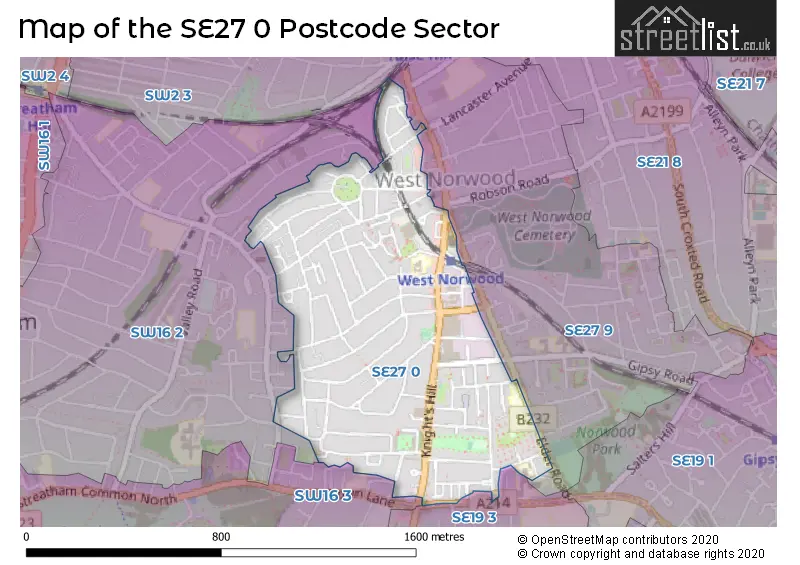
The SE27 0 Postcode shares a border with SE27 9 (LONDON ), SW2 3 (LONDON ), SW16 2 (LONDON ), SW16 3 (NORBURY , LONDON ) and SE19 3 (UPPER NORWOOD , LONDON ).
The sector is within the post town of LONDON.
SE27 0 is a postcode sector within the SE2 postcode district which is within the SE South Eastern London postcode area.
The Royal Mail delivery office for the SE27 0 postal sector is the Abbey Wood Sdelivery Office.
The area of the SE27 0 postcode sector is 0.44 square miles which is 1.14 square kilometres or 282.64 square acres.

Map of the SE27 0 Postcode Sector
Explore the SE27 0 postcode sector by using our free interactive map.
| S | E | 2 | 7 | - | 0 | X | X |
| S | E | 2 | 7 | Space | 0 | Letter | Letter |
Official List of Streets
Lambeth (80 Streets)
Unofficial Streets or Alternative Spellings
Weather Forecast for SE27 0
Press Button to Show Forecast for Crystal Palace National Sports Centre
| Time Period | Icon | Description | Temperature | Rain Probability | Wind |
|---|---|---|---|---|---|
| 21:00 to 00:00 | Cloudy | 12.0°C (feels like 11.0°C) | 15.00% | NE 7 mph |
Press Button to Show Forecast for Crystal Palace National Sports Centre
| Time Period | Icon | Description | Temperature | Rain Probability | Wind |
|---|---|---|---|---|---|
| 00:00 to 03:00 | Cloudy | 12.0°C (feels like 11.0°C) | 7.00% | NNE 4 mph | |
| 03:00 to 06:00 | Clear night | 11.0°C (feels like 10.0°C) | 1.00% | NNE 4 mph | |
| 06:00 to 09:00 | Sunny day | 10.0°C (feels like 9.0°C) | 1.00% | N 7 mph | |
| 09:00 to 12:00 | Sunny day | 14.0°C (feels like 13.0°C) | 0.00% | NNE 7 mph | |
| 12:00 to 15:00 | Partly cloudy (day) | 18.0°C (feels like 16.0°C) | 4.00% | NNE 7 mph | |
| 15:00 to 18:00 | Cloudy | 19.0°C (feels like 17.0°C) | 5.00% | NNE 9 mph | |
| 18:00 to 21:00 | Partly cloudy (day) | 17.0°C (feels like 15.0°C) | 1.00% | NNE 9 mph | |
| 21:00 to 00:00 | Clear night | 14.0°C (feels like 12.0°C) | 1.00% | NE 7 mph |
Press Button to Show Forecast for Crystal Palace National Sports Centre
| Time Period | Icon | Description | Temperature | Rain Probability | Wind |
|---|---|---|---|---|---|
| 00:00 to 03:00 | Clear night | 11.0°C (feels like 10.0°C) | 1.00% | NE 4 mph | |
| 03:00 to 06:00 | Clear night | 9.0°C (feels like 8.0°C) | 2.00% | NNE 4 mph | |
| 06:00 to 09:00 | Overcast | 9.0°C (feels like 8.0°C) | 8.00% | NE 4 mph | |
| 09:00 to 12:00 | Partly cloudy (day) | 12.0°C (feels like 11.0°C) | 2.00% | NE 4 mph | |
| 12:00 to 15:00 | Partly cloudy (day) | 16.0°C (feels like 15.0°C) | 2.00% | NE 4 mph | |
| 15:00 to 18:00 | Partly cloudy (day) | 18.0°C (feels like 17.0°C) | 1.00% | NE 4 mph | |
| 18:00 to 21:00 | Partly cloudy (day) | 18.0°C (feels like 17.0°C) | 2.00% | ENE 4 mph | |
| 21:00 to 00:00 | Cloudy | 14.0°C (feels like 13.0°C) | 5.00% | SE 7 mph |
Press Button to Show Forecast for Crystal Palace National Sports Centre
| Time Period | Icon | Description | Temperature | Rain Probability | Wind |
|---|---|---|---|---|---|
| 00:00 to 03:00 | Partly cloudy (night) | 12.0°C (feels like 11.0°C) | 1.00% | SSE 4 mph | |
| 03:00 to 06:00 | Cloudy | 10.0°C (feels like 10.0°C) | 3.00% | S 4 mph | |
| 06:00 to 09:00 | Sunny day | 11.0°C (feels like 10.0°C) | 2.00% | S 2 mph | |
| 09:00 to 12:00 | Partly cloudy (day) | 14.0°C (feels like 14.0°C) | 1.00% | SSE 2 mph | |
| 12:00 to 15:00 | Cloudy | 18.0°C (feels like 18.0°C) | 4.00% | SE 2 mph | |
| 15:00 to 18:00 | Partly cloudy (day) | 20.0°C (feels like 19.0°C) | 1.00% | ESE 4 mph | |
| 18:00 to 21:00 | Cloudy | 19.0°C (feels like 18.0°C) | 5.00% | ESE 4 mph | |
| 21:00 to 00:00 | Cloudy | 16.0°C (feels like 15.0°C) | 4.00% | SE 4 mph |
Press Button to Show Forecast for Crystal Palace National Sports Centre
| Time Period | Icon | Description | Temperature | Rain Probability | Wind |
|---|---|---|---|---|---|
| 00:00 to 03:00 | Cloudy | 14.0°C (feels like 13.0°C) | 3.00% | SSE 4 mph | |
| 03:00 to 06:00 | Cloudy | 12.0°C (feels like 11.0°C) | 3.00% | S 2 mph | |
| 06:00 to 09:00 | Cloudy | 12.0°C (feels like 12.0°C) | 4.00% | SE 2 mph | |
| 09:00 to 12:00 | Cloudy | 16.0°C (feels like 16.0°C) | 4.00% | ESE 2 mph | |
| 12:00 to 15:00 | Cloudy | 19.0°C (feels like 19.0°C) | 3.00% | ESE 4 mph | |
| 15:00 to 18:00 | Cloudy | 21.0°C (feels like 20.0°C) | 4.00% | ESE 4 mph | |
| 18:00 to 21:00 | Cloudy | 20.0°C (feels like 19.0°C) | 4.00% | ESE 7 mph | |
| 21:00 to 00:00 | Cloudy | 18.0°C (feels like 16.0°C) | 4.00% | SE 7 mph |
Schools and Places of Education Within the SE27 0 Postcode Sector
Julian's School
Foundation school
16 Wolfington Road, London, , SE27 0JF
Head: Ms Alison Moller
Ofsted Rating: Good
Inspection: 2023-06-08 (333 days ago)
Website: Visit Julian's School Website
Phone: 02087611894
Number of Pupils: 1005
St Luke's Church of England Primary School
Academy converter
Linton Grove, London, , SE27 0DZ
Head: Mrs Sophia Bryan-Whyte
Ofsted Rating: Good
Inspection: 2023-05-25 (347 days ago)
Website: Visit St Luke's Church of England Primary School Website
Phone: 02086701981
Number of Pupils: 165
House Prices in the SE27 0 Postcode Sector
| Type of Property | 2018 Average | 2018 Sales | 2017 Average | 2017 Sales | 2016 Average | 2016 Sales | 2015 Average | 2015 Sales |
|---|---|---|---|---|---|---|---|---|
| Detached | £1,103,564 | 7 | £937,500 | 3 | £1,059,600 | 5 | £711,714 | 7 |
| Semi-Detached | £744,404 | 17 | £803,183 | 27 | £773,659 | 29 | £653,933 | 32 |
| Terraced | £652,692 | 37 | £677,209 | 51 | £576,469 | 35 | £545,053 | 50 |
| Flats | £403,643 | 73 | £420,972 | 84 | £362,729 | 60 | £354,955 | 86 |
Important Postcodes SE27 0 in the Postcode Sector
SE27 0DF is the postcode for West Norwood Health & Leisure Centre, 25 Devane Way
SE27 0DZ is the postcode for MAIN SCHOOL BUILDING, St. Lukes C of E Primary School, Linton Grove, St. Lukes C of E Primary School, Linton Grove, and St Lukes Church Of England Primary School, Linton Grove
SE27 0HY is the postcode for OLD LIBRARY GROUND FLOOR, Old Library Youth Centre, 14-16 Knights Hill
SE27 0QA is the postcode for London Fire Brigade, West Norwood Fire Station, 210 Knights Hill, and West Norwood Fire Station, 210 Knights Hill
| The SE27 0 Sector is within these Local Authorities |
|
|---|---|
| The SE27 0 Sector is within these Counties |
|
| The SE27 0 Sector is within these Water Company Areas |
|