The SE19 3 postcode sector is within the county of Greater London.
Did you know? According to the 2021 Census, the SE19 3 postcode sector is home to a bustling 11,352 residents!
Given that each sector allows for 400 unique postcode combinations. Letters C, I, K, M, O and V are not allowed in the last two letters of a postcode. With 229 postcodes already in use, this leaves 171 units available.
The largest settlements in the SE19 3 postal code are UPPER NORWOOD and LONDON .
The SE19 3 Postcode shares a border with SE19 1 (LONDON , UPPER NORWOOD ), SE19 2 (UPPER NORWOOD , ANERLEY , PENGE ), SE25 6 (SOUTH NORWOOD ), SE27 0 (LONDON ), SE27 9 (LONDON ), SW16 3 (NORBURY , LONDON ) and CR7 8 (THORNTON HEATH , CROYDON ).
The sector is within the post town of LONDON.
SE19 3 is a postcode sector within the SE19 postcode district which is within the SE South Eastern London postcode area.
The Royal Mail delivery office for the SE19 3 postal sector is the Norwood Sdelivery Office.
The area of the SE19 3 postcode sector is 0.68 square miles which is 1.77 square kilometres or 437.21 square acres.

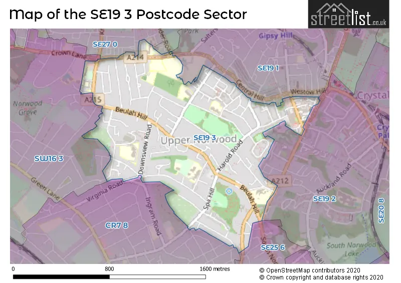
Map of the SE19 3 Postcode Sector
Explore the SE19 3 postcode sector by using our free interactive map.
| S | E | 1 | 9 | - | 3 | X | X |
| S | E | 1 | 9 | Space | 3 | Letter | Letter |
Official List of Streets
Croydon (94 Streets)
Lambeth (2 Streets)
Unofficial Streets or Alternative Spellings
Croydon
ARNULLS ROAD COVINGTON WAY ESSEX MEWS GAYFERE PLACE HAMLYN GARDENS NORBURY HILL SOUTH NORWOOD HILLTHORNTON HEATH
HOWBERRY ROAD INGRAM ROAD NORTHWOOD ROAD VIRGINIA ROAD COURTNEY CLOSE DICKENS WOOD CLOSE EAGLE HILL GIBSONS HILL HILLTOP COURT MOUNT ROAD NESBITT SQUARE RAVENSROOST SAINT AUBYNS ROADBromley
CHURCH ROADLambeth
ELDER ROAD HOLDERNESS WAY TIVOLI ROADWeather Forecast for SE19 3
Press Button to Show Forecast for Crystal Palace National Sports Centre
| Time Period | Icon | Description | Temperature | Rain Probability | Wind |
|---|---|---|---|---|---|
| 12:00 to 15:00 | Cloudy | 11.0°C (feels like 9.0°C) | 14.00% | NE 9 mph | |
| 15:00 to 18:00 | Cloudy | 12.0°C (feels like 10.0°C) | 19.00% | ENE 9 mph | |
| 18:00 to 21:00 | Light rain | 11.0°C (feels like 9.0°C) | 55.00% | ENE 11 mph | |
| 21:00 to 00:00 | Heavy rain | 9.0°C (feels like 7.0°C) | 84.00% | NE 11 mph |
Press Button to Show Forecast for Crystal Palace National Sports Centre
| Time Period | Icon | Description | Temperature | Rain Probability | Wind |
|---|---|---|---|---|---|
| 00:00 to 03:00 | Heavy rain | 9.0°C (feels like 6.0°C) | 86.00% | NE 9 mph | |
| 03:00 to 06:00 | Heavy rain | 9.0°C (feels like 7.0°C) | 87.00% | ENE 9 mph | |
| 06:00 to 09:00 | Heavy rain | 8.0°C (feels like 7.0°C) | 84.00% | E 7 mph | |
| 09:00 to 12:00 | Heavy rain | 9.0°C (feels like 6.0°C) | 81.00% | W 9 mph | |
| 12:00 to 15:00 | Light rain | 9.0°C (feels like 6.0°C) | 57.00% | W 11 mph | |
| 15:00 to 18:00 | Light rain | 10.0°C (feels like 8.0°C) | 47.00% | W 11 mph | |
| 18:00 to 21:00 | Cloudy | 11.0°C (feels like 9.0°C) | 10.00% | WSW 9 mph | |
| 21:00 to 00:00 | Partly cloudy (night) | 9.0°C (feels like 7.0°C) | 3.00% | SW 7 mph |
Press Button to Show Forecast for Crystal Palace National Sports Centre
| Time Period | Icon | Description | Temperature | Rain Probability | Wind |
|---|---|---|---|---|---|
| 00:00 to 03:00 | Clear night | 8.0°C (feels like 6.0°C) | 2.00% | SW 4 mph | |
| 03:00 to 06:00 | Clear night | 7.0°C (feels like 5.0°C) | 1.00% | SSW 4 mph | |
| 06:00 to 09:00 | Sunny day | 7.0°C (feels like 6.0°C) | 1.00% | S 4 mph | |
| 09:00 to 12:00 | Sunny day | 11.0°C (feels like 9.0°C) | 1.00% | S 9 mph | |
| 12:00 to 15:00 | Cloudy | 14.0°C (feels like 12.0°C) | 5.00% | S 11 mph | |
| 15:00 to 18:00 | Partly cloudy (day) | 15.0°C (feels like 12.0°C) | 2.00% | S 11 mph | |
| 18:00 to 21:00 | Sunny day | 14.0°C (feels like 12.0°C) | 2.00% | S 9 mph | |
| 21:00 to 00:00 | Clear night | 11.0°C (feels like 10.0°C) | 1.00% | SE 7 mph |
Press Button to Show Forecast for Crystal Palace National Sports Centre
| Time Period | Icon | Description | Temperature | Rain Probability | Wind |
|---|---|---|---|---|---|
| 00:00 to 03:00 | Clear night | 10.0°C (feels like 8.0°C) | 1.00% | SE 7 mph | |
| 03:00 to 06:00 | Clear night | 9.0°C (feels like 7.0°C) | 3.00% | ESE 7 mph | |
| 06:00 to 09:00 | Sunny day | 9.0°C (feels like 8.0°C) | 5.00% | ESE 7 mph | |
| 09:00 to 12:00 | Partly cloudy (day) | 12.0°C (feels like 11.0°C) | 4.00% | SE 7 mph | |
| 12:00 to 15:00 | Cloudy | 15.0°C (feels like 14.0°C) | 10.00% | SE 9 mph | |
| 15:00 to 18:00 | Cloudy | 16.0°C (feels like 14.0°C) | 13.00% | SE 9 mph | |
| 18:00 to 21:00 | Cloudy | 16.0°C (feels like 14.0°C) | 11.00% | SE 9 mph | |
| 21:00 to 00:00 | Cloudy | 13.0°C (feels like 12.0°C) | 11.00% | ESE 7 mph |
Schools and Places of Education Within the SE19 3 Postcode Sector
All Saints CofE Primary School
Voluntary aided school
Upper Beulah Hill, London, , SE19 3LG
Head: Mrs Josephine Copeland
Ofsted Rating: Good
Inspection: 2019-01-30 (1914 days ago)
Website: Visit All Saints CofE Primary School Website
Phone: 02087719388
Number of Pupils: 257
Downsview Primary and Nursery School
Community school
Biggin Way, London, , SE19 3XE
Head: Ms Meghan Pugh
Ofsted Rating: Good
Inspection: 2019-01-15 (1929 days ago)
Website: Visit Downsview Primary and Nursery School Website
Phone: 02087644611
Number of Pupils: 615
Priory School
Community special school
Hermitage Road, London, , SE19 3QN
Head: Mrs Julie Evans
Ofsted Rating: Good
Inspection: 2023-03-29 (395 days ago)
Website: Visit Priory School Website
Phone: 02086538222
Number of Pupils: 139
Rockmount Primary School
Community school
Chevening Road, London, , SE19 3ST
Head: Headteacher Helen Carvall
Ofsted Rating: Outstanding
Inspection: 2015-05-21 (3264 days ago)
Website: Visit Rockmount Primary School Website
Phone: 02086532619
Number of Pupils: 457
St Joseph's College
Academy converter
Beulah Hill, London, , SE19 3HL
Head: Mrs Catherine Kane
Ofsted Rating: Good
Inspection: 2020-02-26 (1522 days ago)
Website: Visit St Joseph's College Website
Phone: 02087611426
Number of Pupils: 1008
St Joseph's RC Infant School
Voluntary aided school
Crown Dale, London, , SE19 3NX
Head: Mrs Danielle Ashley
Ofsted Rating: Good
Inspection: 2019-01-10 (1934 days ago)
Website: Visit St Joseph's RC Infant School Website
Phone: 02086702385
Number of Pupils: 160
St Joseph's RC Junior School
Voluntary aided school
Woodend, Select, , SE19 3NU
Head: Mrs Danielle Ashley
Ofsted Rating: Outstanding
Inspection: 2018-06-14 (2144 days ago)
Website: Visit St Joseph's RC Junior School Website
Phone: 02086537195
Number of Pupils: 206
The Norwood School
Community school
Crown Dale, London, , SE19 3NY
Head: Co Headteacher Niki Clemenger Richard Cole
Ofsted Rating: Good
Inspection: 2023-02-23 (429 days ago)
Website: Visit The Norwood School Website
Phone: 02086709382
Number of Pupils: 1065
House Prices in the SE19 3 Postcode Sector
| Type of Property | 2018 Average | 2018 Sales | 2017 Average | 2017 Sales | 2016 Average | 2016 Sales | 2015 Average | 2015 Sales |
|---|---|---|---|---|---|---|---|---|
| Detached | £763,958 | 12 | £973,111 | 9 | £828,125 | 16 | £710,909 | 17 |
| Semi-Detached | £508,122 | 20 | £772,929 | 21 | £546,454 | 23 | £465,578 | 25 |
| Terraced | £521,751 | 38 | £489,006 | 37 | £494,815 | 27 | £439,845 | 50 |
| Flats | £304,390 | 82 | £328,891 | 90 | £327,007 | 99 | £275,569 | 133 |
Important Postcodes SE19 3 in the Postcode Sector
SE19 3LG is the postcode for All Saints CE Primary, Upper Beulah Hill, All Saints C Of E Primary School, Upper Beulah Hill, Upper Norwood, and All Saints CE Primary, Upper Beulah Hill, Upper Norwood
SE19 3NU is the postcode for St. Josephs RC Junior School, Woodend
SE19 3NX is the postcode for St. Josephs Infant School, Crown Dale
SE19 3NY is the postcode for SPORTS HALL, Norwood School, Crown Dale, MAIN BUILDING, Norwood School, Crown Dale, and Norwood School, Crown Dale
SE19 3QN is the postcode for Priory School, Hermitage Road
SE19 3RS is the postcode for Royal Mail, Norwood Delivery Office, 20 Westow Street
SE19 3ST is the postcode for Rockmount Primary School, Rockmount Road
SE19 3UG is the postcode for HARRIS ACADEMY SOUTH NORWOOD, Upper Norwood Site, SPURGEON ROAD, MAIN BUILDING, Harris Academy Upper Norwood, Spurgeon Road, SCIENCE BLOCK, HARRIS ACADEMY UPPER NORWOOD, SPURGEON ROAD, Harris Academy Beulah Hill, SPURGEON ROAD, LANGUAGES & PERFORMING ARTS, Harris Academy Upper Norwood, Spurgeon Road, Languages and Performing Arts Centre, HARRIS ACADEMY SOUTH NORWOOD, Upper Norwood Site, Languages and Performing Arts Centre, Harris Academy Beulah Hill, Harris Academy Upper Norwood, Spurgeon Road, and SPORTS HALL, Harris Academy Upper Norwood, Spurgeon Road
SE19 3XE is the postcode for Downsview Primary & Nursery School, Biggin Way
| The SE19 3 Sector is within these Local Authorities |
|
|---|---|
| The SE19 3 Sector is within these Counties |
|
| The SE19 3 Sector is within these Water Company Areas |
|