The SO16 9 postcode sector is within the county of Hampshire.
Did you know? According to the 2021 Census, the SO16 9 postcode sector is home to a bustling 12,789 residents!
Given that each sector allows for 400 unique postcode combinations. Letters C, I, K, M, O and V are not allowed in the last two letters of a postcode. With 258 postcodes already in use, this leaves 142 units available.
The SO16 9 postal code covers the settlement of SOUTHAMPTON.
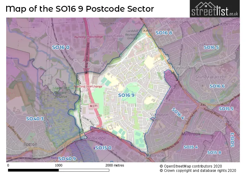
The SO16 9 Postcode shares a border with SO15 0 (SOUTHAMPTON, Western Docks), SO16 4 (SOUTHAMPTON), SO16 6 (SOUTHAMPTON), SO40 3 (Totton), SO16 0 (Nursling), SO16 5 (SOUTHAMPTON) and SO16 8 (SOUTHAMPTON, Rownhams, Nursling).
The sector is within the post town of SOUTHAMPTON.
SO16 9 is a postcode sector within the SO16 postcode district which is within the SO Southampton postcode area.
The Royal Mail delivery office for the SO16 9 postal sector is the Shirley (so) Delivery Office.
The area of the SO16 9 postcode sector is 1.07 square miles which is 2.78 square kilometres or 686.88 square acres.
The SO16 9 postcode sector is crossed by the M271 motorway.


Map of the SO16 9 Postcode Sector
Explore the SO16 9 postcode sector by using our free interactive map.
| S | O | 1 | 6 | - | 9 | X | X |
| S | O | 1 | 6 | Space | 9 | Letter | Letter |
Official List of Streets
SOUTHAMPTON (104 Streets)
Unofficial Streets or Alternative Spellings
SOUTHAMPTON
ASHMEAD ROAD CARDINAL PLACE COXFORD ROAD KENNEDY ROAD LANCASTER ROAD REDBRIDGE CAUSEWAY REDBRIDGE ROAD ROSEWALL ROAD ROWNHAMS ROAD UPPER BROWNHILL ROADNursling
BROWNHILL WAY FROGMORE LANE ROMSEY ROAD ALLINGTON ROAD BROWNHILL COURT COLNE COURT GRASMERE COURT INSPECTION PLATFORM LINK ROAD LORDS HILL ROUNDABOUT MANSEL COURT MILLBROOK ROUNDABOUT NURSLING SPUR MOTORWAY OLD REDBRIDGE REDBRIDGE FLYOVER REDBRIDGE ROUNDABOUTSchools and Places of Education Within the SO16 9 Postcode Sector
Compass School
Pupil referral unit
Green Lane, Southampton, Hampshire, SO16 9FQ
Head: Ms Debbie McKenzie
Ofsted Rating: Good
Inspection: 2022-11-16 (568 days ago)
Website: Visit Compass School Website
Phone: 02380215320
Number of Pupils: 43
Holy Family Catholic Primary School - Part of the Learning Federation Partnership of Schools
Voluntary aided school
Mansel Road West, Southampton, Hampshire, SO16 9LP
Head: Executive Head Gerida Montague & Co Headteacher Sarah Hendricks
Ofsted Rating: Outstanding
Inspection: 2019-03-27 (1898 days ago)
Website: Visit Holy Family Catholic Primary School - Part of the Learning Federation Partnership of Schools Website
Phone: 02380773264
Number of Pupils: 418
Mansel Park Primary & Nursery School - Part of the Learning Federation Partnership of Schools
Community school
Culver Close, Southampton, Hampshire, SO16 9HZ
Head: Mrs Gerida Montague
Ofsted Rating: Good
Inspection: 2019-07-11 (1792 days ago)
Website: Visit Mansel Park Primary & Nursery School - Part of the Learning Federation Partnership of Schools Website
Phone: 02380776162
Number of Pupils: 346
Newlands Primary School
Foundation school
Windermere Avenue, Southampton, Hampshire, SO16 9QX
Head: Mrs Karen Mellor
Ofsted Rating: Good
Inspection: 2018-06-13 (2185 days ago)
Website: Visit Newlands Primary School Website
Phone: 02380773363
Number of Pupils: 399
Redbridge Community School
Foundation school
Cuckmere Lane, Southampton, Hampshire, SO16 9RJ
Head: Mr Jason Ashley
Ofsted Rating: Good
Inspection: 2023-07-13 (329 days ago)
Website: Visit Redbridge Community School Website
Phone: 02380771381
Number of Pupils: 1072
Redbridge Primary School
Foundation school
Studland Road, Southampton, Hampshire, SO16 9BB
Head: Mrs A Payne
Ofsted Rating: Good
Inspection: 2019-03-19 (1906 days ago)
Website: Visit Redbridge Primary School Website
Phone: 02380776379
Number of Pupils: 208
House Prices in the SO16 9 Postcode Sector
| Type of Property | 2018 Average | 2018 Sales | 2017 Average | 2017 Sales | 2016 Average | 2016 Sales | 2015 Average | 2015 Sales |
|---|---|---|---|---|---|---|---|---|
| Detached | £268,125 | 4 | £270,769 | 8 | £255,661 | 9 | £227,917 | 6 |
| Semi-Detached | £243,774 | 27 | £216,630 | 23 | £208,443 | 23 | £195,915 | 24 |
| Terraced | £203,975 | 61 | £194,710 | 48 | £175,685 | 73 | £190,947 | 101 |
| Flats | £125,744 | 41 | £124,949 | 39 | £123,082 | 37 | £120,083 | 47 |
Important Postcodes SO16 9 in the Postcode Sector
SO16 9BB is the postcode for Redbridge Primary School, Studland Road
SO16 9EA is the postcode for Newlands Primary School, Ullswater Road
SO16 9FQ is the postcode for Compass School, Green Lane, and Oasis Pre-School, Green Lane
SO16 9HZ is the postcode for MANSEL PARK PRIMARY SCHOOL, CULVER CLOSE, SOUTHAMPTON, and Mansel Park Primary School, Culver Close
SO16 9JR is the postcode for Whitehaven Lodge, Buttermere Close
SO16 9LA is the postcode for Brownhill House Residential Home, Lower Brownhill Road
SO16 9LP is the postcode for Holy Family RC Primary School, Mansel Road West, JUNIOR BUILDING, Holy Family RC Primary School, Mansel Road West, INFANT BUILDING, Holy Family RC Primary School, Mansel Road West, and PRIMARY CATHOLIC TRAINING CENTRE, Holy Family RC Primary School, Mansel Road West
SO16 9QX is the postcode for Pickles Coppice, 65 Windermere Avenue, and Newlands Primary School, Windermere Avenue
SO16 9QZ is the postcode for Southampton Solent University Sports Pavilion, Test Park, Lower Brownhill Road, and Solent University Sports Pavilion, Test Park, Lower Brownhill Road
SO16 9RG is the postcode for Oasis Academy Lordshill, Lower Site
SO16 9RJ is the postcode for E BLOCK, Redbridge Community School, Cuckmere Lane, Redbridge Community School, Cuckmere Lane, and NEW TEACHING BLOCK, Redbridge Community School, Cuckmere Lane
| The SO16 9 Sector is within these Local Authorities |
|
|---|---|
| The SO16 9 Sector is within these Counties |
|
| The SO16 9 Sector is within these Water Company Areas |
|