The SR6 9 postcode sector is within the county of Tyne & Wear.
Did you know? According to the 2021 Census, the SR6 9 postcode sector is home to a bustling 8,061 residents!
Given that each sector allows for 400 unique postcode combinations. Letters C, I, K, M, O and V are not allowed in the last two letters of a postcode. With 202 postcodes already in use, this leaves 198 units available.
The SR6 9 postal code covers the settlement of SUNDERLAND.
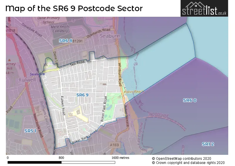
The SR6 9 Postcode shares a border with SR6 0 (SUNDERLAND), SR6 8 (SUNDERLAND) and SR5 1 (SUNDERLAND).
The sector is within the post town of SUNDERLAND.
SR6 9 is a postcode sector within the SR6 postcode district which is within the SR Sunderland postcode area.
The Royal Mail delivery office for the SR6 9 postal sector is the Sunderland Delivery Office.
The area of the SR6 9 postcode sector is 0.50 square miles which is 1.31 square kilometres or 322.75 square acres.

Map of the SR6 9 Postcode Sector
Explore the SR6 9 postcode sector by using our free interactive map.
| S | R | 6 | - | 9 | X | X |
| S | R | 6 | Space | 9 | Letter | Letter |
Official List of Streets
SUNDERLAND (137 Streets)
Unofficial Streets or Alternative Spellings
SUNDERLAND
BEDE STREET BENEDICT ROAD BOWER STREET BRANDLING STREET BRIGHT STREET CHAPMAN STREET DENE LANE FORSTER STREET GLADSTONE STREET LAINDON AVENUE MARINE WALK MITFORD STREET MORAN STREET RIPON STREET SEABURN GARDENS THORBURN STREET WHITBURN TERRACE CAT AND DOG STEPS CROMARTY STREET GILL SIDE GROVE LYN-THORPE GROVE STANHOPE ROAD SUTHERLAND STREETWeather Forecast for SR6 9
Press Button to Show Forecast for Roker
| Time Period | Icon | Description | Temperature | Rain Probability | Wind |
|---|---|---|---|---|---|
| 00:00 to 03:00 | Overcast | 9.0°C (feels like 7.0°C) | 20.00% | NW 9 mph | |
| 03:00 to 06:00 | Overcast | 9.0°C (feels like 8.0°C) | 18.00% | WNW 7 mph | |
| 06:00 to 09:00 | Overcast | 10.0°C (feels like 9.0°C) | 14.00% | WSW 4 mph | |
| 09:00 to 12:00 | Overcast | 12.0°C (feels like 11.0°C) | 11.00% | SW 7 mph | |
| 12:00 to 15:00 | Overcast | 14.0°C (feels like 12.0°C) | 12.00% | SSW 9 mph | |
| 15:00 to 18:00 | Overcast | 15.0°C (feels like 13.0°C) | 12.00% | SSW 11 mph | |
| 18:00 to 21:00 | Cloudy | 14.0°C (feels like 12.0°C) | 8.00% | SW 9 mph | |
| 21:00 to 00:00 | Cloudy | 11.0°C (feels like 10.0°C) | 6.00% | S 7 mph |
Press Button to Show Forecast for Roker
| Time Period | Icon | Description | Temperature | Rain Probability | Wind |
|---|---|---|---|---|---|
| 00:00 to 03:00 | Cloudy | 10.0°C (feels like 9.0°C) | 7.00% | SSW 7 mph | |
| 03:00 to 06:00 | Cloudy | 10.0°C (feels like 8.0°C) | 9.00% | SSW 7 mph | |
| 06:00 to 09:00 | Cloudy | 10.0°C (feels like 9.0°C) | 9.00% | SSW 7 mph | |
| 09:00 to 12:00 | Cloudy | 12.0°C (feels like 11.0°C) | 11.00% | SSE 7 mph | |
| 12:00 to 15:00 | Partly cloudy (day) | 14.0°C (feels like 12.0°C) | 7.00% | SE 9 mph | |
| 15:00 to 18:00 | Cloudy | 13.0°C (feels like 11.0°C) | 9.00% | ESE 11 mph | |
| 18:00 to 21:00 | Partly cloudy (day) | 12.0°C (feels like 11.0°C) | 7.00% | ESE 9 mph | |
| 21:00 to 00:00 | Cloudy | 11.0°C (feels like 9.0°C) | 10.00% | ESE 7 mph |
Schools and Places of Education Within the SR6 9 Postcode Sector
Fulwell Junior School
Community school
Sea Road, Sunderland, Tyne and Wear, SR6 9EE
Head: Mr Peter Speck
Ofsted Rating: Outstanding
Inspection: 2022-03-10 (786 days ago)
Website: Visit Fulwell Junior School Website
Phone: 01915493333
Number of Pupils: 343
Redby Academy
Academy converter
Fulwell Road, Sunderland, Tyne and Wear, SR6 9QP
Head: Headteacher Melanie Wight
Ofsted Rating: Good
Inspection: 2023-03-29 (402 days ago)
Website: Visit Redby Academy Website
Phone: 01915484040
Number of Pupils: 315
St Benet's Roman Catholic Voluntary Aided Primary School
Voluntary aided school
Fulwell Road, Sunderland, Tyne and Wear, SR6 9QU
Head: Mrs Ann Alice Blakey
Ofsted Rating: Good
Inspection: 2018-11-13 (1999 days ago)
Website: Visit St Benet's Roman Catholic Voluntary Aided Primary School Website
Phone: 01915492020
Number of Pupils: 345
House Prices in the SR6 9 Postcode Sector
| Type of Property | 2018 Average | 2018 Sales | 2017 Average | 2017 Sales | 2016 Average | 2016 Sales | 2015 Average | 2015 Sales |
|---|---|---|---|---|---|---|---|---|
| Detached | £307,400 | 5 | £404,800 | 5 | £243,488 | 4 | £249,779 | 7 |
| Semi-Detached | £178,833 | 36 | £191,131 | 51 | £163,851 | 40 | £178,492 | 42 |
| Terraced | £143,714 | 104 | £126,678 | 91 | £139,118 | 100 | £133,112 | 106 |
| Flats | £114,250 | 16 | £107,938 | 8 | £110,050 | 24 | £93,990 | 5 |
Important Postcodes SR6 9 in the Postcode Sector
SR6 9AE is the postcode for Station House, Station Road, and Tyne & Wear Fire & Rescue Service, Fire Station, Station Road
SR6 9EE is the postcode for FULWELL JUNIOR SCHOOL, SEA ROAD, SUNDERLAND, and Fulwell Junior School, Sea Road
SR6 9NH is the postcode for The Close, Rock Lodge Road
SR6 9QP is the postcode for Redby Academy, Fulwell Road
SR6 9QU is the postcode for St. Benets RC Primary School, Fulwell Road, and SAINT BENETS R C PRIMARY SCHOOL, FULWELL ROAD, SUNDERLAND
SR6 9QW is the postcode for Fulwell Day Centre, Fulwell Road
| The SR6 9 Sector is within these Local Authorities |
|
|---|---|
| The SR6 9 Sector is within these Counties |
|
| The SR6 9 Sector is within these Water Company Areas |
|