The TN27 9 postcode sector is within the county of Kent.
Did you know? According to the 2021 Census, the TN27 9 postcode sector is home to a bustling 5,424 residents!
Given that each sector allows for 400 unique postcode combinations. Letters C, I, K, M, O and V are not allowed in the last two letters of a postcode. With 229 postcodes already in use, this leaves 171 units available.
The largest settlements in the TN27 9 postal code are Headcorn and Egerton.
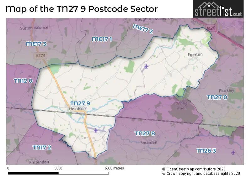
The TN27 9 Postcode shares a border with TN27 0 (Charing, Pluckley, Charing Heath), TN12 0 (Staplehurst, Hawkenbury), ME17 1 (Harrietsham, Hollingbourne, Leeds), ME17 2 (Lenham, Lenham Heath, Grafty Green), ME17 3 (Sutton Valence, MAIDSTONE, Langley), TN17 2 (Frittenden, Sissinghurst, CRANBROOK) and TN27 8 (Biddenden, Smarden).
The sector is within the post town of ASHFORD.
TN27 9 is a postcode sector within the TN27 postcode district which is within the TN Tonbridge postcode area.
The Royal Mail delivery office for the TN27 9 postal sector is the Ashford (tn) Delivery Office and Headcorn Scale Payment Delivery Office and Egerton Scale Payment Delivery Office.
The area of the TN27 9 postcode sector is 15.67 square miles which is 40.58 square kilometres or 10,027.29 square acres.
Waterways within the TN27 9 postcode sector include the Beult, Hammer Stream, Sherway.

Map of the TN27 9 Postcode Sector
Explore the TN27 9 postcode sector by using our free interactive map.
| T | N | 2 | 7 | - | 9 | X | X |
| T | N | 2 | 7 | Space | 9 | Letter | Letter |
Official List of Streets
Headcorn (100 Streets)
Egerton (29 Streets)
Unofficial Streets or Alternative Spellings
East Sutton
EAST SUTTON ROADSutton Valence
HEADCORN ROADBiddenden
AYLESWADE LANEStaplehurst
BOARDEN LANEWeather Forecast for TN27 9
Press Button to Show Forecast for Iden Croft Herbs Staplehurst
| Time Period | Icon | Description | Temperature | Rain Probability | Wind |
|---|---|---|---|---|---|
| 21:00 to 00:00 | Cloudy | 13.0°C (feels like 12.0°C) | 4.00% | NW 7 mph |
Press Button to Show Forecast for Iden Croft Herbs Staplehurst
| Time Period | Icon | Description | Temperature | Rain Probability | Wind |
|---|---|---|---|---|---|
| 00:00 to 03:00 | Cloudy | 12.0°C (feels like 11.0°C) | 8.00% | N 9 mph | |
| 03:00 to 06:00 | Cloudy | 11.0°C (feels like 11.0°C) | 12.00% | NNE 4 mph | |
| 06:00 to 09:00 | Cloudy | 12.0°C (feels like 11.0°C) | 10.00% | N 7 mph | |
| 09:00 to 12:00 | Overcast | 14.0°C (feels like 14.0°C) | 48.00% | NW 4 mph | |
| 12:00 to 15:00 | Overcast | 16.0°C (feels like 16.0°C) | 10.00% | WSW 7 mph | |
| 15:00 to 18:00 | Cloudy | 17.0°C (feels like 15.0°C) | 8.00% | WSW 9 mph | |
| 18:00 to 21:00 | Overcast | 14.0°C (feels like 13.0°C) | 12.00% | WSW 9 mph | |
| 21:00 to 00:00 | Overcast | 12.0°C (feels like 10.0°C) | 13.00% | WSW 11 mph |
Press Button to Show Forecast for Iden Croft Herbs Staplehurst
| Time Period | Icon | Description | Temperature | Rain Probability | Wind |
|---|---|---|---|---|---|
| 00:00 to 03:00 | Overcast | 11.0°C (feels like 9.0°C) | 17.00% | WSW 13 mph | |
| 03:00 to 06:00 | Overcast | 10.0°C (feels like 8.0°C) | 16.00% | WSW 13 mph | |
| 06:00 to 09:00 | Light rain | 10.0°C (feels like 7.0°C) | 43.00% | WSW 13 mph | |
| 09:00 to 12:00 | Cloudy | 11.0°C (feels like 8.0°C) | 18.00% | WSW 16 mph | |
| 12:00 to 15:00 | Overcast | 13.0°C (feels like 10.0°C) | 15.00% | WSW 18 mph | |
| 15:00 to 18:00 | Cloudy | 14.0°C (feels like 11.0°C) | 13.00% | WSW 16 mph | |
| 18:00 to 21:00 | Cloudy | 13.0°C (feels like 11.0°C) | 6.00% | WSW 11 mph | |
| 21:00 to 00:00 | Clear night | 11.0°C (feels like 9.0°C) | 2.00% | SW 9 mph |
Press Button to Show Forecast for Iden Croft Herbs Staplehurst
| Time Period | Icon | Description | Temperature | Rain Probability | Wind |
|---|---|---|---|---|---|
| 00:00 to 03:00 | Clear night | 9.0°C (feels like 7.0°C) | 1.00% | SW 9 mph | |
| 03:00 to 06:00 | Clear night | 8.0°C (feels like 7.0°C) | 2.00% | SSW 7 mph | |
| 06:00 to 09:00 | Sunny day | 9.0°C (feels like 8.0°C) | 4.00% | SSW 7 mph | |
| 09:00 to 12:00 | Partly cloudy (day) | 13.0°C (feels like 11.0°C) | 6.00% | SSW 9 mph | |
| 12:00 to 15:00 | Partly cloudy (day) | 14.0°C (feels like 13.0°C) | 10.00% | S 9 mph | |
| 15:00 to 18:00 | Cloudy | 15.0°C (feels like 13.0°C) | 15.00% | SSE 9 mph | |
| 18:00 to 21:00 | Cloudy | 13.0°C (feels like 12.0°C) | 14.00% | SE 9 mph | |
| 21:00 to 00:00 | Partly cloudy (night) | 11.0°C (feels like 10.0°C) | 11.00% | SE 7 mph |
Press Button to Show Forecast for Iden Croft Herbs Staplehurst
| Time Period | Icon | Description | Temperature | Rain Probability | Wind |
|---|---|---|---|---|---|
| 00:00 to 03:00 | Cloudy | 11.0°C (feels like 9.0°C) | 15.00% | S 7 mph | |
| 03:00 to 06:00 | Cloudy | 10.0°C (feels like 9.0°C) | 12.00% | S 7 mph | |
| 06:00 to 09:00 | Cloudy | 10.0°C (feels like 9.0°C) | 13.00% | SSW 7 mph | |
| 09:00 to 12:00 | Cloudy | 13.0°C (feels like 12.0°C) | 12.00% | S 9 mph | |
| 12:00 to 15:00 | Cloudy | 14.0°C (feels like 12.0°C) | 19.00% | SSW 9 mph | |
| 15:00 to 18:00 | Cloudy | 14.0°C (feels like 12.0°C) | 20.00% | SSW 9 mph | |
| 18:00 to 21:00 | Cloudy | 13.0°C (feels like 12.0°C) | 15.00% | SE 7 mph | |
| 21:00 to 00:00 | Cloudy | 12.0°C (feels like 11.0°C) | 8.00% | SSW 4 mph |
Schools and Places of Education Within the TN27 9 Postcode Sector
Egerton Church of England Primary School
Voluntary controlled school
Stisted Way, Ashford, Kent, TN27 9DR
Head: Mrs Julia Walker
Ofsted Rating: Good
Inspection: 2023-10-12 (202 days ago)
Website: Visit Egerton Church of England Primary School Website
Phone: 01233756274
Number of Pupils: 188
Headcorn Primary School
Community school
Kings Road, Headcorn, Kent, TN27 9QT
Head: Miss Sarah Symonds
Ofsted Rating: Requires improvement
Inspection: 2022-05-05 (727 days ago)
Website: Visit Headcorn Primary School Website
Phone: 01622891289
Number of Pupils: 392
House Prices in the TN27 9 Postcode Sector
| Type of Property | 2018 Average | 2018 Sales | 2017 Average | 2017 Sales | 2016 Average | 2016 Sales | 2015 Average | 2015 Sales |
|---|---|---|---|---|---|---|---|---|
| Detached | £505,144 | 43 | £529,180 | 64 | £598,778 | 32 | £436,908 | 44 |
| Semi-Detached | £358,247 | 27 | £351,367 | 34 | £286,233 | 15 | £311,881 | 26 |
| Terraced | £274,033 | 15 | £322,987 | 13 | £307,452 | 21 | £275,175 | 20 |
| Flats | £176,300 | 5 | £163,541 | 11 | £212,813 | 8 | £191,150 | 3 |
Important Postcodes TN27 9 in the Postcode Sector
TN27 9AA is the postcode for Headcorn Surgery, The Hardwicks
TN27 9DR is the postcode for Egerton Cp School, Rock Hill Road, EGERTON CHURCH OF ENGLAND PRIMARY SCHOOL, STISTED WAY, EGERTON, and Egerton Church of England Primary School, Stisted Way
TN27 9QT is the postcode for Headcorn Primary School, Kings Road, Headcorn Cp School, Kings Road, OLD SCHOOL, Headcorn Cp School, Kings Road, HEADCORN CP SCHOOL, KINGS ROAD, HEADCORN, and JUNIOR CLASSROOM BLOCK 2018, Headcorn Cp School, Kings Road
| The TN27 9 Sector is within these Local Authorities |
|
|---|---|
| The TN27 9 Sector is within these Counties |
|
| The TN27 9 Sector is within these Water Company Areas |
|