The TN5 7 postcode sector stands on the East Sussex and Kent border.
Did you know? According to the 2021 Census, the TN5 7 postcode sector is home to a bustling 3,842 residents!
Given that each sector allows for 400 unique postcode combinations. Letters C, I, K, M, O and V are not allowed in the last two letters of a postcode. With 170 postcodes already in use, this leaves 230 units available.
The largest settlement in the TN5 7 postal code is Ticehurst followed by Flimwell, and Stonegate.
The TN5 7 Postcode shares a border with TN19 7 (Burwash, Hurst Green, ETCHINGHAM), TN20 6 (MAYFIELD, Five Ashes, Wellbrook), TN3 8 (Lamberhurst, Hook Green), TN5 6 (WADHURST, Sparrows Green, Durgates), TN17 2 (Frittenden, Sissinghurst, CRANBROOK), TN18 4 (Hawkhurst) and TN18 5 (Sandhurst, Hawkhurst, Newenden).
The sector is within the post town of WADHURST.
TN5 7 is a postcode sector within the TN5 postcode district which is within the TN Tonbridge postcode area.
The Royal Mail delivery office for the TN5 7 postal sector is the Tunbridge Wells Delivery Office.
The area of the TN5 7 postcode sector is 14.48 square miles which is 37.50 square kilometres or 9,265.24 square acres.
The TN5 7 postcode sector is crossed by the A21 Major A road.

Map of the TN5 7 Postcode Sector
Explore the TN5 7 postcode sector by using our free interactive map.
| T | N | 5 | - | 7 | X | X |
| T | N | 5 | Space | 7 | Letter | Letter |
Official List of Streets
Ticehurst (36 Streets)
Stonegate (8 Streets)
Flimwell (19 Streets)
Wallcrouch (3 Streets)
Unofficial Streets or Alternative Spellings
Burwash
SHRUB LANEETCHINGHAM
SHEEPSTREET LANEKilndown
CHURCH ROADWADHURST
LOWER HIGH STREET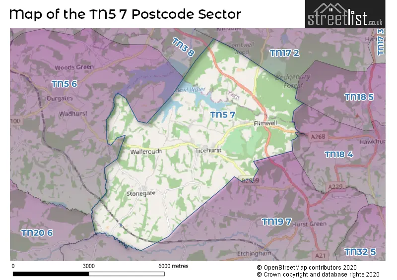
House Prices in the TN5 7 Postcode Sector
| Type of Property | 2018 Average | 2018 Sales | 2017 Average | 2017 Sales | 2016 Average | 2016 Sales | 2015 Average | 2015 Sales |
|---|---|---|---|---|---|---|---|---|
| Detached | £693,975 | 20 | £582,987 | 19 | £832,567 | 15 | £557,841 | 18 |
| Semi-Detached | £354,063 | 16 | £351,240 | 16 | £380,399 | 21 | £339,692 | 18 |
| Terraced | £325,833 | 9 | £339,991 | 16 | £300,174 | 17 | £291,964 | 14 |
| Flats | £241,056 | 9 | £229,400 | 5 | £245,688 | 8 | £285,500 | 8 |
Important Postcodes TN5 7 in the Postcode Sector
TN5 7DH is the postcode for Ticehurst C of E Primary School, Steellands Rise
TN5 7EN is the postcode for Stonegate C of E Primary School, Station Road
| The TN5 7 Sector is within these Local Authorities |
|
|---|---|
| The TN5 7 Sector is within these Counties |
|
| The TN5 7 Sector is within these Water Company Areas |
|
Tourist Attractions within the TN5 7 Postcode Area
We found 3 visitor attractions within the TN5 postcode area
| Pashley Manor Gardens |
|---|
| Gardens |
| Garden |
| View Pashley Manor Gardens on Google Maps |
| Bedgebury National Pinetum & Forest |
| Country Parks |
| Country Park |
| View Bedgebury National Pinetum & Forest on Google Maps |
| Go Ape! High Wire Forest Adventure - Bedgebury |
| Country Parks |
| Country Park |
| View Go Ape! High Wire Forest Adventure - Bedgebury on Google Maps |