The UB7 7 postcode sector lies where the three counties of Berkshire, Buckinghamshire, and Greater London meet.
Did you know? According to the 2021 Census, the UB7 7 postcode sector is home to a bustling 10,768 residents!
Given that each sector allows for 400 unique postcode combinations. Letters C, I, K, M, O and V are not allowed in the last two letters of a postcode. With 210 postcodes already in use, this leaves 190 units available.
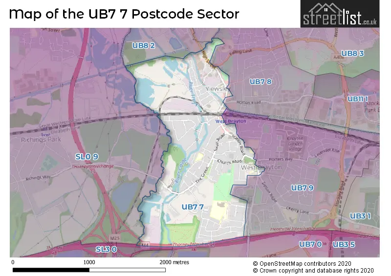
The largest settlements in the UB7 7 postal code are WEST DRAYTON and YIEWSLEY .
The UB7 7 Postcode shares a border with UB7 8 (WEST DRAYTON , UXBRIDGE ), UB7 9 (WEST DRAYTON ), UB8 3 (UXBRIDGE ), SL0 9 (IVER ), SL3 0 (POYLE, COLNBROOK), UB7 0 (WEST DRAYTON , LONGFORD , SIPSON ) and UB8 2 (UXBRIDGE , COWLEY ).
The sector is within the post town of WEST DRAYTON.
UB7 7 is a postcode sector within the UB7 postcode district which is within the UB Uxbridge postcode area.
The Royal Mail delivery office for the UB7 7 postal sector is the Uxbridge Delivery Office.
The area of the UB7 7 postcode sector is 1.11 square miles which is 2.88 square kilometres or 711.29 square acres.
The UB7 7 postcode sector is crossed by the M25 motorway.
The UB7 7 postcode sector is crossed by the M4 motorway.
Waterways within the UB7 7 postcode sector include the Grand Union Canal, Grand Union Canal - Slough Arm, Wraysbury River, Duke of Northumberland's River.


Map of the UB7 7 Postcode Sector
Explore the UB7 7 postcode sector by using our free interactive map.
| U | B | 7 | - | 7 | X | X |
| U | B | 7 | Space | 7 | Letter | Letter |
Official List of Streets
WEST DRAYTON (67 Streets)
Yiewsley (14 Streets)
Unofficial Streets or Alternative Spellings
WEST DRAYTON
BRANDVILLE ROAD HARMONDSWORTH ROAD THORNTON AVENUE WARWICK ROADSipson
SIPSON ROAD CANAL WAY CANAL WAY - LONDON LOOP CELANDINE ROUTE COLHAM BRIDGE COLNE VALLEY TRAIL DONKEY LANE FRAYS ISLAND PATH FRAYS RIVER BRIDGE LONDON LOOP MILL COURT NEW PARADE PARK VIEW RIVER COLNE BRIDGE TROUT LANE TROUT LANE---COLNE VALLEY TRAIL---BEECHES WAY---SHAKESPEARES WAY TROUT LANE--LONDON LOOP--COLNE VALLEY TRAIL Y8Yiewsley
FAIRFIELD ROAD FALLING LANE STATION APPROACHCowley
HIGH ROADIVER,
THORNEY MILL ROADSchools and Places of Education Within the UB7 7 Postcode Sector
Laurel Lane Primary School
Academy sponsor led
Laurel Lane, West Drayton, Middlesex, UB7 7TX
Head: Mrs Sandra Voisey
Ofsted Rating: Requires improvement
Inspection: 2022-10-05 (613 days ago)
Website: Visit Laurel Lane Primary School Website
Phone: 01895462360
Number of Pupils: 362
St Catherine Catholic Primary School
Voluntary aided school
Money Lane, West Drayton, , UB7 7NX
Head: Mr Peter Doherty
Ofsted Rating: Good
Inspection: 2023-11-22 (200 days ago)
Website: Visit St Catherine Catholic Primary School Website
Phone: 01895442839
Number of Pupils: 225
St Martin's Church of England Primary School
Academy sponsor led
Rowan Road, West Drayton, Middlesex, UB7 7UF
Head: Ms Johann Coates
Ofsted Rating: Good
Inspection: 2023-09-20 (263 days ago)
Website: Visit St Martin's Church of England Primary School Website
Phone: 01895462350
Number of Pupils: 317
St Matthew's CofE Primary School
Academy converter
High Street, West Drayton, , UB7 7QJ
Head: Mrs Natasha Moffatt
Ofsted Rating: Good
Inspection: 2022-07-07 (703 days ago)
Website: Visit St Matthew's CofE Primary School Website
Phone: 01895442724
Number of Pupils: 414
House Prices in the UB7 7 Postcode Sector
| Type of Property | 2018 Average | 2018 Sales | 2017 Average | 2017 Sales | 2016 Average | 2016 Sales | 2015 Average | 2015 Sales |
|---|---|---|---|---|---|---|---|---|
| Detached | £563,140 | 10 | £661,633 | 15 | £523,429 | 7 | £457,167 | 12 |
| Semi-Detached | £493,817 | 33 | £452,902 | 33 | £427,313 | 24 | £376,178 | 30 |
| Terraced | £386,605 | 31 | £377,112 | 23 | £392,022 | 18 | £294,242 | 26 |
| Flats | £323,325 | 89 | £280,574 | 54 | £277,713 | 130 | £229,847 | 97 |
Important Postcodes UB7 7 in the Postcode Sector
UB7 7DP is the postcode for Yiewsley Health Centre, 20 High Street
UB7 7JQ is the postcode for Metropolitan Police, Station Road
UB7 7NX is the postcode for St. Catherines RC Primary School, Money Lane
UB7 7QJ is the postcode for ST STEPHEN'S/KS1, St. Matthews C of E Primary School, High Street, and St. Matthews C of E Primary School, High Street
UB7 7TX is the postcode for Laurel Lane Primary School, Laurel Lane
UB7 7UF is the postcode for St. MartinG��s Primary School, Rowan Road
| The UB7 7 Sector is within these Local Authorities |
|
|---|---|
| The UB7 7 Sector is within these Counties |
|
| The UB7 7 Sector is within these Water Company Areas |
|