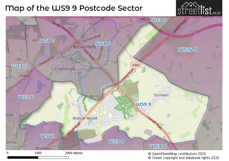
The WS9 9 postcode sector stands on the Staffordshire and West Midlands border.
Did you know? According to the 2021 Census, the WS9 9 postcode sector is home to a bustling 8,526 residents!
Given that each sector allows for 400 unique postcode combinations. Letters C, I, K, M, O and V are not allowed in the last two letters of a postcode. With 159 postcodes already in use, this leaves 241 units available.
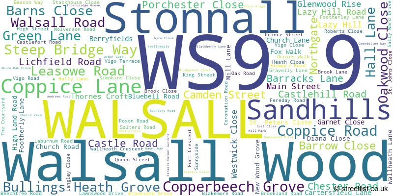
The largest settlement in the WS9 9 postal code is WALSALL followed by Walsall Wood, and Stonnall.
The WS9 9 Postcode shares a border with WS7 0 (BURNTWOOD, Hammerwich), WS8 6 (Brownhills, WALSALL), WS8 7 (WALSALL, Brownhills, Clayhanger), WS9 0 (WALSALL, Aldridge), WS9 8 (WALSALL, Aldridge), WS14 0 (LICHFIELD, Shenstone, Weeford), WS3 4 (WALSALL, Pelsall) and WS4 1 (WALSALL, Rushall, Shelfield).
The sector is within the post town of WALSALL.
WS9 9 is a postcode sector within the WS9 postcode district which is within the WS Walsall postcode area.
The Royal Mail delivery office for the WS9 9 postal sector is the Aldridge Delivery Office.
The area of the WS9 9 postcode sector is 4.00 square miles which is 10.35 square kilometres or 2,558.06 square acres.
The WS9 9 postcode sector is crossed by the M6 motorway.
Waterways within the WS9 9 postcode sector include the Daw End Branch Canal.

Map of the WS9 9 Postcode Sector
Explore the WS9 9 postcode sector by using our free interactive map.
| W | S | 9 | - | 9 | X | X |
| W | S | 9 | Space | 9 | Letter | Letter |
Official List of Streets
Walsall Wood (44 Streets)
WALSALL (45 Streets)
Stonnall (12 Streets)
Unofficial Streets or Alternative Spellings
LICHFIELD,
FOOTHERLEY LANEWALSALL
BANKSIDE WAY BRANCHAL ROAD BROWNHILLS ROAD GREENWOOD PARK GREENWOOD ROAD MOB LANE WALSALL WOOD ROADLynn
LYNN LANEAldridge
BIRCH LANE CHESTER ROAD LAZY HILL ROAD NORTHGATE BOATMANS LANE BOBS DRIVE CHESTERFIELD COURT DOWNES GATE DRIVE THROUGH FAR VIEW HILL VIEW LINK ROAD LONGLEAT ROAD OAKWOOD PLACE RADNOR COURT STREETS CORNER VICARAGE ROAD WALL HEATH LANEBrownhills
BARRACKS LANEShelfield
GREEN LANESchools and Places of Education Within the WS9 9 Postcode Sector
Castlefort Junior Mixed and Infant School
Community school
Castlefort Road, Walsall, West Midlands, WS9 9JP
Head: Mrs Joanne Wilson
Ofsted Rating: Good
Inspection: 2020-01-22 (1583 days ago)
Website: Visit Castlefort Junior Mixed and Infant School Website
Phone: 01543452158
Number of Pupils: 235
Oakwood School
Community special school
Druids Walk, Walsall, West Midlands, WS9 9JS
Head: Mrs Kate Bargh
Ofsted Rating: Outstanding
Inspection: 2018-10-02 (2060 days ago)
Website: Visit Oakwood School Website
Phone: 01543452040
Number of Pupils: 150
Shire Oak Academy
Academy converter
Lichfield Road, Walsall, West Midlands, WS9 9PA
Head: Mrs Annabel Stoddart
Ofsted Rating: Requires improvement
Inspection: 2022-04-28 (756 days ago)
Website: Visit Shire Oak Academy Website
Phone: 01543452518
Number of Pupils: 1471
St John's Church of England Primary School
Voluntary controlled school
Brook Lane, Walsall, West Midlands, WS9 9NA
Head: Mr Andrew C Mills
Ofsted Rating: Good
Inspection: 2023-10-11 (225 days ago)
Website: Visit St John's Church of England Primary School Website
Phone: 01543452197
Number of Pupils: 358
St Peter's Church of England Primary Academy
Academy converter
Main Street, Walsall, West Midlands, WS9 9EE
Head: Mr Matthew Seex
Ofsted Rating: Good
Inspection: 2019-05-22 (1828 days ago)
Website: Visit St Peter's Church of England Primary Academy Website
Phone: 01543372060
Number of Pupils: 147
House Prices in the WS9 9 Postcode Sector
| Type of Property | 2018 Average | 2018 Sales | 2017 Average | 2017 Sales | 2016 Average | 2016 Sales | 2015 Average | 2015 Sales |
|---|---|---|---|---|---|---|---|---|
| Detached | £332,328 | 49 | £271,715 | 55 | £291,859 | 47 | £285,639 | 45 |
| Semi-Detached | £189,539 | 50 | £200,991 | 55 | £168,221 | 57 | £143,970 | 53 |
| Terraced | £155,583 | 18 | £128,703 | 17 | £139,803 | 18 | £124,882 | 20 |
| Flats | £103,800 | 5 | £94,178 | 9 | £85,600 | 5 | £95,475 | 4 |
Important Postcodes WS9 9 in the Postcode Sector
WS9 9BH is the postcode for OAK PARK ACTIVE LIVING CENTRE, COPPICE ROAD, WALSALL WOOD, and Oak Park Active Living Centre, Coppice Road
WS9 9BU is the postcode for West Midlands Fire Service, Aldridge Fire Station, Northgate, and Aldridge Fire Station, Northgate
WS9 9EE is the postcode for St. Peters C of E Primary School, Main Street
WS9 9JP is the postcode for Castlefort Primary School, Castlefort Road
WS9 9JS is the postcode for Oakwood School, Druids Walk
WS9 9LP is the postcode for St. Johns Medical Centre, High Street
WS9 9NA is the postcode for St. Johns C of E Primary School, Brook Lane, and St. Johns C of E Primary School, Brook Lane, Walsall Wood
WS9 9PA is the postcode for SPORTS BLOCK, Shire Oak School, Lichfield Road, SOUTH BUILDING, Shire Oak Academy, Lichfield Road, NORTH BUILDING, Shire Oak Academy, Lichfield Road, THE KEVIN JONES BUILDING, Shire Oak Academy, Lichfield Road, SOUTH BLOCK, Shire Oak School, Lichfield Road, NEW BLOCK, Shire Oak School, Lichfield Road, NORTH BLOCK, Shire Oak School, Lichfield Road, and MERCIA BUILDING, Shire Oak Academy, Lichfield Road
WS9 9PQ is the postcode for Oak Park Leisure Centre, Lichfield Road
| The WS9 9 Sector is within these Local Authorities |
|
|---|---|
| The WS9 9 Sector is within these Counties |
|
| The WS9 9 Sector is within these Water Company Areas |
|