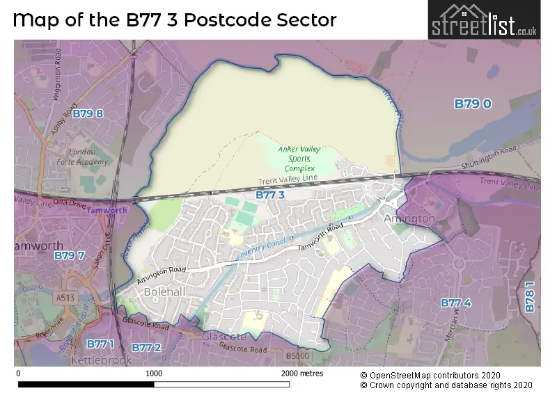
The B77 3 postcode sector is within the county of Staffordshire.
Did you know? According to the 2021 Census, the B77 3 postcode sector is home to a bustling 9,226 residents!
Given that each sector allows for 400 unique postcode combinations. Letters C, I, K, M, O and V are not allowed in the last two letters of a postcode. With 166 postcodes already in use, this leaves 234 units available.
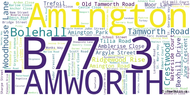
The largest settlement in the B77 3 postal code is TAMWORTH followed by Amington, and Bolehall.
The B77 3 Postcode shares a border with B77 1 (TAMWORTH, Dosthill, Two Gates), B77 2 (TAMWORTH, Glascote, Wilnecote), B77 4 (Wilnecote, TAMWORTH, Amington), B79 0 (TAMWORTH, Warton, Clifton Campville), B79 7 (TAMWORTH) and B79 8 (TAMWORTH).
The sector is within the post town of TAMWORTH.
B77 3 is a postcode sector within the B7 postcode district which is within the B Birmingham postcode area.
The Royal Mail delivery office for the B77 3 postal sector is the unknown.
The area of the B77 3 postcode sector is 1.32 square miles which is 3.43 square kilometres or 847.44 square acres.
Waterways within the B77 3 postcode sector include the Coventry Canal.

Map of the B77 3 Postcode Sector
Explore the B77 3 postcode sector by using our free interactive map.
| B | 7 | 7 | - | 3 | X | X |
| B | 7 | 7 | Space | 3 | Letter | Letter |
Official List of Streets
Amington (36 Streets)
TAMWORTH (64 Streets)
Unofficial Streets or Alternative Spellings
TAMWORTH
CHANDLERS DRIVE CORNEL HAREBELL JUNIPER WOODLAND ROAD ARGYLE MEWS BRINDLEY DRIVE BY PASS ROAD GARAGE CLOSE JASMINE ROAD LANGDALE COURT LINDERA MERCIAN WAY MONKEY BRIDGE MOOR LANE (BOLEHALL) REPINGTON ROAD SOUTH STEPHANIE GROVE TAMWORTH ROAD (AMINGTON)Amington
WATERSIDE COURTGlascote
CLIFFORD CLOSE CLIFFORD STREET GLASCOTE ROADWeather Forecast for B77 3
Press Button to Show Forecast for Tamworth
| Time Period | Icon | Description | Temperature | Rain Probability | Wind |
|---|---|---|---|---|---|
| 09:00 to 12:00 | Cloudy | 14.0°C (feels like 13.0°C) | 4.00% | E 4 mph | |
| 12:00 to 15:00 | Cloudy | 16.0°C (feels like 15.0°C) | 15.00% | ENE 4 mph | |
| 15:00 to 18:00 | Cloudy | 16.0°C (feels like 15.0°C) | 14.00% | NE 7 mph | |
| 18:00 to 21:00 | Cloudy | 15.0°C (feels like 14.0°C) | 49.00% | NNE 9 mph | |
| 21:00 to 00:00 | Cloudy | 14.0°C (feels like 12.0°C) | 7.00% | NNE 9 mph |
Press Button to Show Forecast for Tamworth
| Time Period | Icon | Description | Temperature | Rain Probability | Wind |
|---|---|---|---|---|---|
| 00:00 to 03:00 | Overcast | 11.0°C (feels like 9.0°C) | 10.00% | NNE 11 mph | |
| 03:00 to 06:00 | Overcast | 11.0°C (feels like 8.0°C) | 18.00% | NE 9 mph | |
| 06:00 to 09:00 | Overcast | 11.0°C (feels like 8.0°C) | 9.00% | NNE 11 mph | |
| 09:00 to 12:00 | Cloudy | 13.0°C (feels like 11.0°C) | 9.00% | NE 13 mph | |
| 12:00 to 15:00 | Overcast | 17.0°C (feels like 15.0°C) | 8.00% | NE 11 mph | |
| 15:00 to 18:00 | Cloudy | 19.0°C (feels like 16.0°C) | 5.00% | NE 11 mph | |
| 18:00 to 21:00 | Partly cloudy (day) | 17.0°C (feels like 15.0°C) | 2.00% | NE 9 mph | |
| 21:00 to 00:00 | Cloudy | 13.0°C (feels like 11.0°C) | 6.00% | NE 9 mph |
Press Button to Show Forecast for Tamworth
| Time Period | Icon | Description | Temperature | Rain Probability | Wind |
|---|---|---|---|---|---|
| 00:00 to 03:00 | Overcast | 11.0°C (feels like 10.0°C) | 10.00% | NE 7 mph | |
| 03:00 to 06:00 | Overcast | 11.0°C (feels like 10.0°C) | 13.00% | N 4 mph | |
| 06:00 to 09:00 | Overcast | 11.0°C (feels like 10.0°C) | 15.00% | NW 4 mph | |
| 09:00 to 12:00 | Overcast | 13.0°C (feels like 11.0°C) | 14.00% | NW 7 mph | |
| 12:00 to 15:00 | Overcast | 15.0°C (feels like 14.0°C) | 14.00% | WNW 9 mph | |
| 15:00 to 18:00 | Cloudy | 16.0°C (feels like 14.0°C) | 14.00% | WNW 9 mph | |
| 18:00 to 21:00 | Overcast | 15.0°C (feels like 13.0°C) | 18.00% | WNW 9 mph | |
| 21:00 to 00:00 | Cloudy | 13.0°C (feels like 11.0°C) | 11.00% | WNW 9 mph |
Press Button to Show Forecast for Tamworth
| Time Period | Icon | Description | Temperature | Rain Probability | Wind |
|---|---|---|---|---|---|
| 00:00 to 03:00 | Partly cloudy (night) | 11.0°C (feels like 9.0°C) | 7.00% | W 7 mph | |
| 03:00 to 06:00 | Cloudy | 10.0°C (feels like 8.0°C) | 9.00% | W 7 mph | |
| 06:00 to 09:00 | Cloudy | 10.0°C (feels like 8.0°C) | 10.00% | WSW 7 mph | |
| 09:00 to 12:00 | Cloudy | 13.0°C (feels like 11.0°C) | 8.00% | WSW 7 mph | |
| 12:00 to 15:00 | Cloudy | 15.0°C (feels like 14.0°C) | 10.00% | SW 7 mph | |
| 15:00 to 18:00 | Cloudy | 17.0°C (feels like 15.0°C) | 11.00% | SSW 9 mph | |
| 18:00 to 21:00 | Cloudy | 16.0°C (feels like 14.0°C) | 9.00% | W 7 mph | |
| 21:00 to 00:00 | Cloudy | 13.0°C (feels like 12.0°C) | 7.00% | WNW 7 mph |
Schools and Places of Education Within the B77 3 Postcode Sector
Ankermoor Primary Academy
Academy converter
Rene Road, Tamworth, Staffordshire, B77 3NW
Head: Mr Gareth Hancox
Ofsted Rating: Good
Inspection: 2023-06-21 (315 days ago)
Website: Visit Ankermoor Primary Academy Website
Phone: 01827213780
Number of Pupils: 138
Florendine Primary School
Community school
Florendine Street, Tamworth, Staffordshire, B77 3DD
Head: Mr Ian Crookes
Ofsted Rating: Good
Inspection: 2019-10-16 (1659 days ago)
Website: Visit Florendine Primary School Website
Phone: 01827429011
Number of Pupils: 251
The Woodlands Community Primary School
Academy converter
Canning Road, Tamworth, Staffordshire, B77 3JX
Head: Mr Jonathan Baker
Ofsted Rating: Good
Inspection: 2023-11-08 (175 days ago)
Website: Visit The Woodlands Community Primary School Website
Phone: 01827429020
Number of Pupils: 278
House Prices in the B77 3 Postcode Sector
| Type of Property | 2018 Average | 2018 Sales | 2017 Average | 2017 Sales | 2016 Average | 2016 Sales | 2015 Average | 2015 Sales |
|---|---|---|---|---|---|---|---|---|
| Detached | £267,942 | 43 | £287,619 | 30 | £259,394 | 19 | £248,776 | 27 |
| Semi-Detached | £175,589 | 66 | £167,439 | 66 | £162,180 | 76 | £140,120 | 57 |
| Terraced | £161,836 | 28 | £133,800 | 34 | £157,123 | 22 | £125,290 | 24 |
| Flats | £101,750 | 8 | £90,853 | 17 | £85,813 | 8 | £73,290 | 11 |
Important Postcodes B77 3 in the Postcode Sector
B77 3DD is the postcode for Florendine County Primary School, Florendine Street, and Florendine County Primary School, Florendine Street, Amington
B77 3EW is the postcode for Child & Adolescent Mental Health Service, Argyle Street
B77 3JB is the postcode for Woodhouse County High School, Highfield Avenue
B77 3JX is the postcode for Woodlands Primary School, Canning Road, and WOODLANDS PRIMARY SCHOOL, CANNING ROAD, GLASCOTE
B77 3NW is the postcode for ANKERMOOR COUNTY PRIMARY SCHOOL, RENE ROAD, BOLEHALL, and Ankermoor County Primary School, Rene Road
| The B77 3 Sector is within these Local Authorities |
|
|---|---|
| The B77 3 Sector is within these Counties |
|
| The B77 3 Sector is within these Water Company Areas |
|