The B80 postcode district is a postal district located in the B Birmingham postcode area with a population of 7,271 residents according to the 2021 England and Wales Census.
The area of the B80 postcode district is 8.98 square miles which is 23.26 square kilometres or 5,746.65 acres.
Currently, the B80 district has about 210 postcode units spread across 1 geographic postcode sectors.
Given that each sector allows for 400 unique postcode combinations, the district has a capacity of 400 postcodes. With 210 postcodes already in use, this leaves 190 units available.
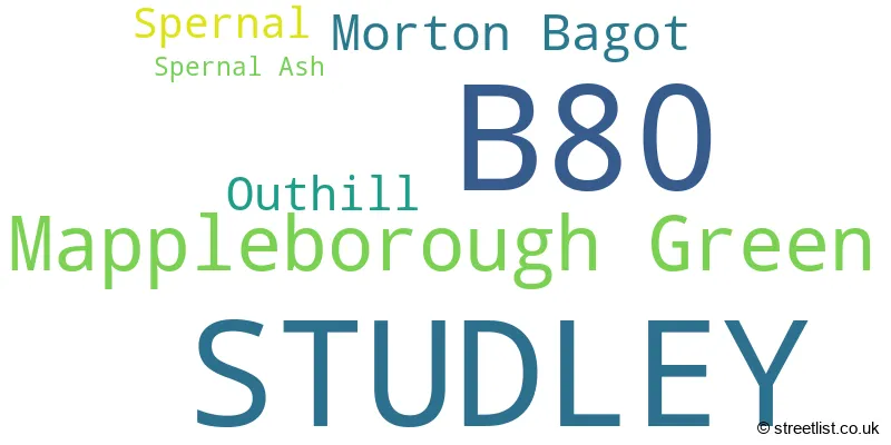
The largest settlement in the B80 postal code is STUDLEY followed by Mappleborough Green, and Morton Bagot.
The B80 Postcode shares a border with B49 (ALCESTER, Great Alne, Cookhill) and B98 (REDDITCH, Beoley, Moons Moat North Industrial Estate).
The primary settlement in the B80 postcode district is STUDLEY, located in Warwickshire. Other significant settlements in the district include Mappleborough Green, Morton Bagot, Outhill, Spernal, and Spernal Ash, all of which are also in Warwickshire. The most significant post town in the district is STUDLEY.
For the district B80, we have data on 1 postcode sectors. Here's a breakdown: The sector B80 7, covers Studley in Warwickshire.
B80 Postcode Sectors

Map of the B80 Postcode District
Explore the B80 postcode district by using our free interactive map.
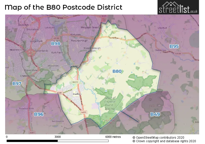
When it comes to local government, postal geography often disregards political borders. However, for a breakdown in the B80 District: the district mostly encompasses the Stratford-on-Avon District (210 postcodes), and finally, the Redditch District (B) area (4 postcodes).
Weather Forecast for B80
Press Button to Show Forecast for Redditch
| Time Period | Icon | Description | Temperature | Rain Probability | Wind |
|---|---|---|---|---|---|
| 12:00 to 15:00 | Light rain | 7.0°C (feels like 4.0°C) | 50.00% | NE 11 mph | |
| 15:00 to 18:00 | Overcast | 8.0°C (feels like 5.0°C) | 15.00% | NE 11 mph | |
| 18:00 to 21:00 | Overcast | 8.0°C (feels like 5.0°C) | 13.00% | NE 11 mph | |
| 21:00 to 00:00 | Overcast | 6.0°C (feels like 3.0°C) | 12.00% | NE 11 mph |
Press Button to Show Forecast for Redditch
| Time Period | Icon | Description | Temperature | Rain Probability | Wind |
|---|---|---|---|---|---|
| 00:00 to 03:00 | Overcast | 6.0°C (feels like 2.0°C) | 17.00% | NNE 11 mph | |
| 03:00 to 06:00 | Overcast | 5.0°C (feels like 2.0°C) | 20.00% | NNE 13 mph | |
| 06:00 to 09:00 | Heavy rain | 6.0°C (feels like 2.0°C) | 76.00% | N 11 mph | |
| 09:00 to 12:00 | Heavy rain | 7.0°C (feels like 3.0°C) | 75.00% | NNW 11 mph | |
| 12:00 to 15:00 | Cloudy | 8.0°C (feels like 6.0°C) | 21.00% | NW 9 mph | |
| 15:00 to 18:00 | Cloudy | 10.0°C (feels like 8.0°C) | 15.00% | WNW 9 mph | |
| 18:00 to 21:00 | Cloudy | 9.0°C (feels like 7.0°C) | 8.00% | WSW 7 mph | |
| 21:00 to 00:00 | Clear night | 6.0°C (feels like 4.0°C) | 2.00% | SW 7 mph |
Press Button to Show Forecast for Redditch
| Time Period | Icon | Description | Temperature | Rain Probability | Wind |
|---|---|---|---|---|---|
| 00:00 to 03:00 | Clear night | 4.0°C (feels like 2.0°C) | 1.00% | SW 4 mph | |
| 03:00 to 06:00 | Clear night | 3.0°C (feels like 1.0°C) | 1.00% | SSW 7 mph | |
| 06:00 to 09:00 | Sunny day | 5.0°C (feels like 2.0°C) | 1.00% | S 7 mph | |
| 09:00 to 12:00 | Partly cloudy (day) | 10.0°C (feels like 8.0°C) | 2.00% | S 11 mph | |
| 12:00 to 15:00 | Overcast | 12.0°C (feels like 9.0°C) | 10.00% | S 13 mph | |
| 15:00 to 18:00 | Cloudy | 13.0°C (feels like 10.0°C) | 6.00% | S 13 mph | |
| 18:00 to 21:00 | Partly cloudy (day) | 12.0°C (feels like 9.0°C) | 4.00% | S 11 mph | |
| 21:00 to 00:00 | Clear night | 8.0°C (feels like 6.0°C) | 4.00% | SSE 9 mph |
Press Button to Show Forecast for Redditch
| Time Period | Icon | Description | Temperature | Rain Probability | Wind |
|---|---|---|---|---|---|
| 00:00 to 03:00 | Clear night | 7.0°C (feels like 5.0°C) | 3.00% | SE 9 mph | |
| 03:00 to 06:00 | Clear night | 7.0°C (feels like 4.0°C) | 2.00% | SE 9 mph | |
| 06:00 to 09:00 | Sunny day | 8.0°C (feels like 5.0°C) | 4.00% | ESE 9 mph | |
| 09:00 to 12:00 | Partly cloudy (day) | 12.0°C (feels like 10.0°C) | 6.00% | SE 11 mph | |
| 12:00 to 15:00 | Partly cloudy (day) | 14.0°C (feels like 12.0°C) | 12.00% | SE 13 mph | |
| 15:00 to 18:00 | Partly cloudy (day) | 15.0°C (feels like 12.0°C) | 10.00% | SE 11 mph | |
| 18:00 to 21:00 | Partly cloudy (day) | 14.0°C (feels like 12.0°C) | 9.00% | SE 9 mph | |
| 21:00 to 00:00 | Cloudy | 11.0°C (feels like 9.0°C) | 9.00% | ESE 7 mph |
Where is the B80 Postcode District?
The B80 postcode district is located in Studley, a town in Warwickshire. Studley is connected to several nearby towns: Redditch is situated to the northwest, Henley-in-Arden to the northeast, Alcester to the south, Solihull to the north, Stratford-upon-Avon to the southeast, Droitwich to the west, and Warwick to the east. Additionally, Studley is approximately 91.6 miles away from the center of London.
The district is within the post town of STUDLEY.
The sector has postcodes within the nation of England.
The B80 Postcode District is covers the following regions.
- Warwickshire - Herefordshire, Worcestershire and Warwickshire - West Midlands (England)
- Worcestershire - Herefordshire, Worcestershire and Warwickshire - West Midlands (England)
Postcode Sectors within the B80 District
| Postcode Sector | Delivery Office |
|---|---|
| B80 7 | Redditch Delivery Office |
| B | 8 | 0 | - | X | X | X |
| B | 8 | 0 | Space | Numeric | Letter | Letter |
Current Monthly Rental Prices
| # Bedrooms | Min Price | Max Price | Avg Price |
|---|
Current House Prices
| # Bedrooms | Min Price | Max Price | Avg Price |
|---|---|---|---|
| £700,000 | £1,750,000 | £1,225,000 | |
| 2 | £275,000 | £375,000 | £304,990 |
| 3 | £295,000 | £420,000 | £369,369 |
| 4 | £290,000 | £950,000 | £598,571 |
| 5 | £775,000 | £1,000,000 | £887,500 |
| 6 | £1,150,000 | £1,150,000 | £1,150,000 |
Estate Agents who Operate in the B80 District
| Logo | Name | Brand Name | Address | Contact Number | Total Properties |
|---|---|---|---|---|---|
 | Worcestershire | Lamberts Sales and Lettings | 11 Alcester Street, Redditch, B98 8AE | 01527 919179 | 14 |
 | Studley | King Homes | The Grange 37 Alcester Road, Studley, B80 7LL | 01527 913682 | 11 |
 | Redditch | A P Morgan | Estate House, 12 Church Green East, Redditch, B98 8BP | 01527 913195 | 3 |
 | Redditch | Arden Estates | 373 Evesham Road, Redditch, B97 5JA | 01527 540654 | 3 |
 | Henley In Arden | Earles | 74 High Street, Henley-In-Arden, B95 5BX | 01564 794343 | 2 |
| Type of Property | 2018 Average | 2018 Sales | 2017 Average | 2017 Sales | 2016 Average | 2016 Sales | 2015 Average | 2015 Sales |
|---|---|---|---|---|---|---|---|---|
| Detached | £384,094 | 32 | £393,681 | 45 | £340,054 | 37 | £321,034 | 46 |
| Semi-Detached | £273,348 | 40 | £227,538 | 53 | £228,369 | 32 | £213,156 | 48 |
| Terraced | £247,889 | 32 | £208,998 | 22 | £182,750 | 32 | £182,904 | 35 |
| Flats | £126,838 | 13 | £119,733 | 15 | £110,466 | 16 | £118,083 | 6 |