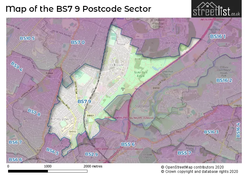
The BS7 9 postcode sector stands on the Bristol and Gloucestershire border.
Did you know? According to the 2021 Census, the BS7 9 postcode sector is home to a bustling 17,076 residents!
Given that each sector allows for 400 unique postcode combinations. Letters C, I, K, M, O and V are not allowed in the last two letters of a postcode. With 277 postcodes already in use, this leaves 123 units available.
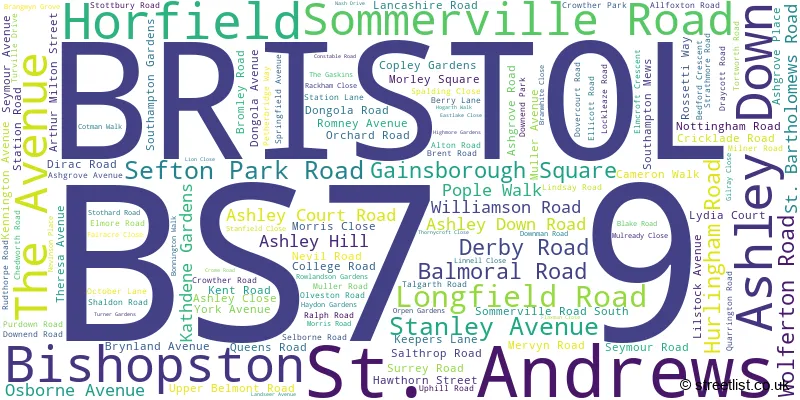
The largest settlement in the BS7 9 postal code is BRISTOL followed by Bishopston, and Horfield.
The BS7 9 Postcode shares a border with BS7 0 (BRISTOL, Horfield), BS2 9 (BRISTOL, St. Pauls, St. Agnes), BS5 6 (BRISTOL, Eastville, Easton), BS6 5 (BRISTOL, St. Andrews, Montpelier), BS7 8 (BRISTOL, Bishopston, Horfield) and BS16 1 (BRISTOL, Stapleton, Hambrook).
The sector is within the post town of BRISTOL.
BS7 9 is a postcode sector within the BS7 postcode district which is within the BS Bristol postcode area.
The Royal Mail delivery office for the BS7 9 postal sector is the Bristol North Delivery Office.
The area of the BS7 9 postcode sector is 1.54 square miles which is 3.98 square kilometres or 984.68 square acres.
The BS7 9 postcode sector is crossed by the M32 motorway.

Map of the BS7 9 Postcode Sector
Explore the BS7 9 postcode sector by using our free interactive map.
| B | S | 7 | - | 9 | X | X |
| B | S | 7 | Space | 9 | Letter | Letter |
Official List of Streets
BRISTOL (113 Streets)
Ashley Down (5 Streets)
Bishopston (5 Streets)
Horfield (5 Streets)
St. Andrews (1 Streets)
Unofficial Streets or Alternative Spellings
BRISTOL
BLAKENEY ROAD BOILING WELLS LANE COLTS GROUND DANBY STREET GREAT CLOVER LEAZE HENRY SHUTE ROAD HERMITAGE WOOD ROAD HORSE LEAZE ROAD LEADER STREET LONG WOOD ROAD MELITA ROAD MERTON ROAD ROUSHAM ROAD SOUTH HAYES WESLEY ROAD WORDSWORTH ROAD BARTON WALK BROOK BRIDGE BRYNLAND COUURT CONCORDE WAY COW BARTON GILLRAY CLOSE HAPPY LANE HERKOMER CLOSE HONEY PENS CRESCENT ISLAND COPSIE LONGWOOD MEADOWS NEVIL LANE RUDTHORPE MEWS RUTLAND ROAD SAINT ANDREWS ROAD SAINT BARTHOLOMEWS ROAD SEYMOUR MEWS SHUBB LEAZE SIR JOHNS LANE ST ANDREWS ROAD STOKE LANE STONEY LANE THORNEYCROFT CLOSE TORTWORTH COURTEastville
MULLER ROADSt. Andrews
BELMONT ROAD CHESTERFIELD ROADStapleton
HEATH HOUSE LANEFilton
FILTON AVENUEWeather Forecast for BS7 9
Press Button to Show Forecast for Lockleaze
| Time Period | Icon | Description | Temperature | Rain Probability | Wind |
|---|---|---|---|---|---|
| 03:00 to 06:00 | Overcast | 6.0°C (feels like 5.0°C) | 8.00% | ENE 4 mph | |
| 06:00 to 09:00 | Cloudy | 6.0°C (feels like 4.0°C) | 8.00% | ENE 7 mph | |
| 09:00 to 12:00 | Cloudy | 8.0°C (feels like 5.0°C) | 10.00% | E 9 mph | |
| 12:00 to 15:00 | Overcast | 10.0°C (feels like 8.0°C) | 15.00% | E 9 mph | |
| 15:00 to 18:00 | Overcast | 10.0°C (feels like 9.0°C) | 19.00% | E 9 mph | |
| 18:00 to 21:00 | Overcast | 10.0°C (feels like 8.0°C) | 19.00% | ENE 7 mph | |
| 21:00 to 00:00 | Cloudy | 8.0°C (feels like 6.0°C) | 16.00% | ENE 7 mph |
Press Button to Show Forecast for Lockleaze
| Time Period | Icon | Description | Temperature | Rain Probability | Wind |
|---|---|---|---|---|---|
| 00:00 to 03:00 | Cloudy | 7.0°C (feels like 4.0°C) | 14.00% | ENE 7 mph | |
| 03:00 to 06:00 | Cloudy | 6.0°C (feels like 4.0°C) | 14.00% | ENE 7 mph | |
| 06:00 to 09:00 | Cloudy | 6.0°C (feels like 3.0°C) | 19.00% | ENE 9 mph | |
| 09:00 to 12:00 | Light rain | 7.0°C (feels like 5.0°C) | 50.00% | ENE 11 mph | |
| 12:00 to 15:00 | Overcast | 10.0°C (feels like 7.0°C) | 21.00% | ENE 11 mph | |
| 15:00 to 18:00 | Cloudy | 11.0°C (feels like 9.0°C) | 16.00% | ENE 11 mph | |
| 18:00 to 21:00 | Overcast | 10.0°C (feels like 8.0°C) | 22.00% | NE 9 mph | |
| 21:00 to 00:00 | Light rain | 9.0°C (feels like 6.0°C) | 48.00% | NE 11 mph |
Press Button to Show Forecast for Lockleaze
| Time Period | Icon | Description | Temperature | Rain Probability | Wind |
|---|---|---|---|---|---|
| 00:00 to 03:00 | Light rain | 8.0°C (feels like 5.0°C) | 51.00% | NE 11 mph | |
| 03:00 to 06:00 | Light rain | 7.0°C (feels like 5.0°C) | 50.00% | NE 9 mph | |
| 06:00 to 09:00 | Light rain | 7.0°C (feels like 5.0°C) | 52.00% | NNE 9 mph | |
| 09:00 to 12:00 | Light rain | 9.0°C (feels like 6.0°C) | 52.00% | NNE 9 mph | |
| 12:00 to 15:00 | Light rain shower (day) | 11.0°C (feels like 9.0°C) | 45.00% | NNW 11 mph | |
| 15:00 to 18:00 | Light rain shower (day) | 11.0°C (feels like 9.0°C) | 43.00% | NW 11 mph | |
| 18:00 to 21:00 | Light rain shower (day) | 11.0°C (feels like 9.0°C) | 35.00% | NNW 9 mph | |
| 21:00 to 00:00 | Partly cloudy (night) | 9.0°C (feels like 7.0°C) | 7.00% | NW 7 mph |
Schools and Places of Education Within the BS7 9 Postcode Sector
Ashley Down Primary School
Community school
Downend Road, Bristol, , BS7 9PD
Head: Mrs Amy Sood
Ofsted Rating: Good
Inspection: 2019-01-31 (1912 days ago)
Website: Visit Ashley Down Primary School Website
Phone: 01173772637
Number of Pupils: 400
Brunel Field Primary School
Community school
College Road, Bristol, , BS7 9JT
Head: Mrs Julie Waldren
Ofsted Rating: Good
Inspection: 2023-11-22 (156 days ago)
Website: Visit Brunel Field Primary School Website
Phone: 01173532471
Number of Pupils: 417
Fairfield High School
Academy converter
Allfoxton Road, Bristol, , BS7 9NL
Head: Ms Amanda Bridgewater
Ofsted Rating: Good
Inspection: 2023-02-09 (442 days ago)
Website: Visit Fairfield High School Website
Phone: 01179527100
Number of Pupils: 1073
Filton Avenue Primary School
Academy converter
Lockleaze Road, Bristol, , BS7 9RP
Head: Mr Dan Rodeck
Ofsted Rating: Good
Inspection: 2022-03-16 (772 days ago)
Website: Visit Filton Avenue Primary School Website
Phone: 01179030302
Number of Pupils: 588
Sefton Park Infant School
Community school
Ashley Down Road, Bristol, , BS7 9BJ
Head: Mr D Simson
Ofsted Rating: Good
Inspection: 2020-02-12 (1535 days ago)
Website: Visit Sefton Park Infant School Website
Phone: 01173773290
Number of Pupils: 218
Sefton Park Junior School
Community school
Ashley Down Road, Bristol, , BS7 9BJ
Head: Mr Daniel Simson
Ofsted Rating: Good
Inspection: 2023-03-01 (422 days ago)
Website: Visit Sefton Park Junior School Website
Phone: 01173773290
Number of Pupils: 226
Stoke Park Primary School
Academy converter
Brangwyn Grove, Bristol, , BS7 9BY
Head: Mrs Alison Lambert
Ofsted Rating: Good
Inspection: 2023-10-04 (205 days ago)
Website: Visit Stoke Park Primary School Website
Phone: 01173772840
Number of Pupils: 237
House Prices in the BS7 9 Postcode Sector
| Type of Property | 2018 Average | 2018 Sales | 2017 Average | 2017 Sales | 2016 Average | 2016 Sales | 2015 Average | 2015 Sales |
|---|---|---|---|---|---|---|---|---|
| Detached | £230,000 | 1 | £384,278 | 3 | £0 | 0 | £289,833 | 3 |
| Semi-Detached | £352,138 | 38 | £366,283 | 50 | £309,557 | 42 | £273,696 | 43 |
| Terraced | £426,887 | 122 | £381,544 | 132 | £389,884 | 141 | £331,309 | 167 |
| Flats | £253,737 | 75 | £236,174 | 56 | £229,219 | 91 | £204,564 | 83 |
Important Postcodes BS7 9 in the Postcode Sector
BS7 9BJ is the postcode for Sefton Park Infant and Junior School, St. Bartholomews Road, and Sefton Park Infant School, St. Bartholomews Road
BS7 9BU is the postcode for CABOT HOUSE, City of Bristol College, Brunel Centre, Ashley Down Road, CABOT HOUSE, City of Bristol College, Brunel Centre, DAVY HOUSE, City of Bristol College, Brunel Centre, Ashley Down Road, and BRUNEL HOUSE, City of Bristol College, Brunel Centre, Ashley Down Road
BS7 9BY is the postcode for STOKE PARK PRIMARY SCHOOL, ROMNEY AVENUE, LOCKLEAZE, Stoke Park Primary School, Brangwyn Grove, and Trinity Academy Bristol, Romney Avenue, Lockleaze
BS7 9FT is the postcode for Brunel Field Primary School, College Rd, Bishopston
BS7 9JT is the postcode for Ashley Down Primary School, Ashley Down Road
BS7 9NL is the postcode for Fairfield High School, Allfoxton Road
BS7 9PD is the postcode for Ashley Down Junior School, Downend Road, Horfield, and Ashley Down Junior School, Downend Road
BS7 9PE is the postcode for Ashley Down Infant School, Olveston Road
BS7 9RP is the postcode for BUILDING B, Filton Avenue Junior School, Lockleaze Road, BUILDING C, Filton Avenue Infant School, Lockleaze Road, BUILDING B, Filton Avenue Junior School, Lockleaze Road., Filton Avenue Infant School, Lockleaze Road, and BUILDING A, Filton Avenue Junior School, Lockleaze Road
BS7 9TB is the postcode for Bristol City Council, Romney House, Romney Avenue
| The BS7 9 Sector is within these Local Authorities |
|
|---|---|
| The BS7 9 Sector is within these Counties |
|
| The BS7 9 Sector is within these Water Company Areas |
|