The CH49 7 postcode sector is within the county of Merseyside.
Did you know? According to the 2021 Census, the CH49 7 postcode sector is home to a bustling 2,556 residents!
Given that each sector allows for 400 unique postcode combinations. Letters C, I, K, M, O and V are not allowed in the last two letters of a postcode. With 46 postcodes already in use, this leaves 354 units available.
The largest settlement in the CH49 7 postal code is WIRRAL followed by Upton, and Woodchurch.
The CH49 7 Postcode shares a border with CH49 5 (WIRRAL, Upton), CH49 8 (WIRRAL, Upton) and CH43 9 (PRENTON).
The sector is within the post town of WIRRAL.
CH49 7 is a postcode sector within the CH49 postcode district which is within the CH Chester postcode area.
The Royal Mail delivery office for the CH49 7 postal sector is the Upton (ch) Delivery Office.
The area of the CH49 7 postcode sector is 0.26 square miles which is 0.66 square kilometres or 163.59 square acres.
The CH49 7 postcode sector is crossed by the M53 motorway.

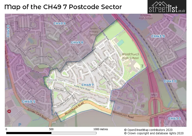
Map of the CH49 7 Postcode Sector
Explore the CH49 7 postcode sector by using our free interactive map.
| C | H | 4 | 9 | - | 7 | X | X |
| C | H | 4 | 9 | Space | 7 | Letter | Letter |
Official List of Streets
WIRRAL (19 Streets)
Upton (2 Streets)
Unofficial Streets or Alternative Spellings
Weather Forecast for CH49 7
Press Button to Show Forecast for Noctorum
| Time Period | Icon | Description | Temperature | Rain Probability | Wind |
|---|---|---|---|---|---|
| 03:00 to 06:00 | Clear night | 15.0°C (feels like 14.0°C) | 0.00% | SE 7 mph | |
| 06:00 to 09:00 | Partly cloudy (day) | 15.0°C (feels like 13.0°C) | 0.00% | SE 9 mph | |
| 09:00 to 12:00 | Partly cloudy (day) | 18.0°C (feels like 16.0°C) | 0.00% | SE 11 mph | |
| 12:00 to 15:00 | Cloudy | 21.0°C (feels like 18.0°C) | 3.00% | SE 11 mph | |
| 15:00 to 18:00 | Cloudy | 22.0°C (feels like 20.0°C) | 4.00% | SE 11 mph | |
| 18:00 to 21:00 | Cloudy | 22.0°C (feels like 19.0°C) | 3.00% | SE 11 mph | |
| 21:00 to 00:00 | Cloudy | 19.0°C (feels like 16.0°C) | 4.00% | ESE 11 mph |
Press Button to Show Forecast for Noctorum
| Time Period | Icon | Description | Temperature | Rain Probability | Wind |
|---|---|---|---|---|---|
| 00:00 to 03:00 | Cloudy | 17.0°C (feels like 15.0°C) | 4.00% | SE 11 mph | |
| 03:00 to 06:00 | Cloudy | 15.0°C (feels like 13.0°C) | 3.00% | SE 11 mph | |
| 06:00 to 09:00 | Cloudy | 14.0°C (feels like 13.0°C) | 3.00% | SE 9 mph | |
| 09:00 to 12:00 | Cloudy | 17.0°C (feels like 15.0°C) | 3.00% | SE 11 mph | |
| 12:00 to 15:00 | Cloudy | 20.0°C (feels like 18.0°C) | 5.00% | SE 11 mph | |
| 15:00 to 18:00 | Cloudy | 22.0°C (feels like 20.0°C) | 18.00% | SSE 11 mph | |
| 18:00 to 21:00 | Light rain shower (day) | 19.0°C (feels like 18.0°C) | 51.00% | SW 7 mph | |
| 21:00 to 00:00 | Light rain | 17.0°C (feels like 16.0°C) | 54.00% | SSE 7 mph |
Press Button to Show Forecast for Noctorum
| Time Period | Icon | Description | Temperature | Rain Probability | Wind |
|---|---|---|---|---|---|
| 00:00 to 03:00 | Partly cloudy (night) | 15.0°C (feels like 14.0°C) | 10.00% | SW 7 mph | |
| 03:00 to 06:00 | Partly cloudy (night) | 13.0°C (feels like 13.0°C) | 12.00% | SW 4 mph | |
| 06:00 to 09:00 | Cloudy | 13.0°C (feels like 13.0°C) | 9.00% | SE 4 mph | |
| 09:00 to 12:00 | Cloudy | 15.0°C (feels like 13.0°C) | 11.00% | SSE 11 mph | |
| 12:00 to 15:00 | Cloudy | 16.0°C (feels like 13.0°C) | 19.00% | SE 16 mph | |
| 15:00 to 18:00 | Cloudy | 16.0°C (feels like 13.0°C) | 23.00% | SE 16 mph | |
| 18:00 to 21:00 | Heavy rain | 15.0°C (feels like 12.0°C) | 79.00% | SE 16 mph | |
| 21:00 to 00:00 | Heavy rain | 14.0°C (feels like 12.0°C) | 85.00% | SE 13 mph |
Press Button to Show Forecast for Noctorum
| Time Period | Icon | Description | Temperature | Rain Probability | Wind |
|---|---|---|---|---|---|
| 00:00 to 03:00 | Heavy rain | 14.0°C (feels like 12.0°C) | 80.00% | SSE 13 mph | |
| 03:00 to 06:00 | Light rain | 13.0°C (feels like 11.0°C) | 51.00% | SE 11 mph | |
| 06:00 to 09:00 | Cloudy | 13.0°C (feels like 11.0°C) | 17.00% | SE 11 mph | |
| 09:00 to 12:00 | Cloudy | 14.0°C (feels like 12.0°C) | 17.00% | SSE 13 mph | |
| 12:00 to 15:00 | Partly cloudy (day) | 16.0°C (feels like 13.0°C) | 16.00% | SSE 13 mph | |
| 15:00 to 18:00 | Light rain shower (day) | 16.0°C (feels like 14.0°C) | 38.00% | S 13 mph | |
| 18:00 to 21:00 | Light rain shower (day) | 15.0°C (feels like 13.0°C) | 38.00% | S 13 mph | |
| 21:00 to 00:00 | Partly cloudy (night) | 14.0°C (feels like 12.0°C) | 10.00% | SSE 11 mph |
Press Button to Show Forecast for Noctorum
| Time Period | Icon | Description | Temperature | Rain Probability | Wind |
|---|---|---|---|---|---|
| 00:00 to 03:00 | Partly cloudy (night) | 13.0°C (feels like 10.0°C) | 6.00% | SSE 13 mph | |
| 03:00 to 06:00 | Cloudy | 12.0°C (feels like 9.0°C) | 8.00% | SSE 13 mph | |
| 06:00 to 09:00 | Partly cloudy (day) | 12.0°C (feels like 9.0°C) | 5.00% | SSE 13 mph | |
| 09:00 to 12:00 | Partly cloudy (day) | 14.0°C (feels like 11.0°C) | 13.00% | SSE 16 mph | |
| 12:00 to 15:00 | Partly cloudy (day) | 16.0°C (feels like 13.0°C) | 14.00% | SSE 13 mph | |
| 15:00 to 18:00 | Light rain shower (day) | 16.0°C (feels like 13.0°C) | 38.00% | SSE 13 mph | |
| 18:00 to 21:00 | Light rain shower (day) | 15.0°C (feels like 13.0°C) | 37.00% | S 11 mph | |
| 21:00 to 00:00 | Partly cloudy (night) | 13.0°C (feels like 11.0°C) | 7.00% | S 11 mph |
Schools and Places of Education Within the CH49 7 Postcode Sector
Woodchurch CofE Primary School
Voluntary aided school
Church Lane, Wirral, Merseyside, CH49 7LS
Head: Mr Brian McGregor
Ofsted Rating: Special Measures
Inspection: 2023-09-14 (240 days ago)
Website: Visit Woodchurch CofE Primary School Website
Phone: 01516774788
Number of Pupils: 204
Woodchurch High School
Academy converter
Carr Bridge Road, Wirral, Merseyside, CH49 7NG
Head: Mr Martyn Canham
Ofsted Rating: Good
Inspection: 2020-02-12 (1550 days ago)
Website: Visit Woodchurch High School Website
Phone: 01516775257
Number of Pupils: 1426
House Prices in the CH49 7 Postcode Sector
| Type of Property | 2018 Average | 2018 Sales | 2017 Average | 2017 Sales | 2016 Average | 2016 Sales | 2015 Average | 2015 Sales |
|---|---|---|---|---|---|---|---|---|
| Detached | £100,000 | 1 | £0 | 0 | £0 | 0 | £0 | 0 |
| Semi-Detached | £98,875 | 8 | £96,106 | 9 | £74,500 | 2 | £75,000 | 1 |
| Terraced | £102,688 | 28 | £104,491 | 16 | £94,020 | 19 | £92,723 | 23 |
| Flats | £0 | 0 | £0 | 0 | £0 | 0 | £65,000 | 1 |
Important Postcodes CH49 7 in the Postcode Sector
CH49 7LP is the postcode for Commonfield Road Surgery, 156 Commonfield Road
CH49 7LS is the postcode for Woodchurch C of E Primary School, Church Lane
CH49 7NG is the postcode for WOODCHURCH HIGH SCHOOL NEW SCHOOL SITE, Woodchurch High School Engineering College, Carr Bridge Road, Woodchurch High Sports Complex Limited, Woodchurch High School, Carr Bridge Road, WOODCHURCH HIGH SPORTS COMPLEX, Woodchurch High School, Carr Bridge Road, Woodchurch High School, Carr Bridge Road, WOODCHURCH HIGH SCHOOL NEW SCHOOL SITE, Woodchurch High School, Carr Bridge Road, and STUDY CENTRE, Woodchurch High School, Carr Bridge Road
| The CH49 7 Sector is within these Local Authorities |
|
|---|---|
| The CH49 7 Sector is within these Counties |
|
| The CH49 7 Sector is within these Water Company Areas |
|