The CT10 2 postcode sector is within the county of Kent.
Did you know? According to the 2021 Census, the CT10 2 postcode sector is home to a bustling 10,409 residents!
Given that each sector allows for 400 unique postcode combinations. Letters C, I, K, M, O and V are not allowed in the last two letters of a postcode. With 285 postcodes already in use, this leaves 115 units available.
The largest settlement in the CT10 2 postal code is BROADSTAIRS followed by St. Peters, and Pysons Road Industrial Estate.
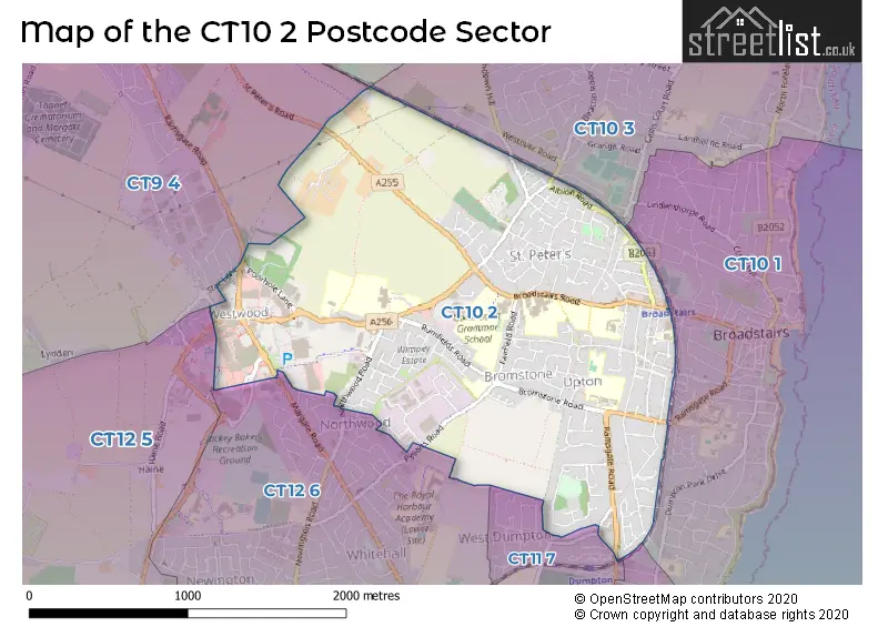
The CT10 2 Postcode shares a border with CT9 3 (MARGATE, Cliftonville), CT9 4 (MARGATE, Westwood), CT10 1 (BROADSTAIRS), CT11 7 (RAMSGATE), CT12 5 (Manston, Cliffsend, RAMSGATE), CT12 6 (RAMSGATE, Eurokent Business Park), CT10 3 (BROADSTAIRS, St. Peters) and CT11 8 (RAMSGATE).
The sector is within the post town of BROADSTAIRS.
CT10 2 is a postcode sector within the CT9 postcode district which is within the CT Canterbury postcode area.
The Royal Mail delivery office for the CT10 2 postal sector is the Margate Delivery Office.
The area of the CT10 2 postcode sector is 2.00 square miles which is 5.18 square kilometres or 1,279.38 square acres.

Map of the CT10 2 Postcode Sector
Explore the CT10 2 postcode sector by using our free interactive map.
| C | T | 1 | 0 | - | 2 | X | X |
| C | T | 1 | 0 | Space | 2 | Letter | Letter |
Official List of Streets
BROADSTAIRS (152 Streets)
Pysons Road Industrial Estate (5 Streets)
Unofficial Streets or Alternative Spellings
BROADSTAIRS
BAIRDS HILL BEACON ROAD ANTOLIN WAY BROMSTONE PLACE CRAMPTON COURT DADSON WAY FLINT GROVE HAINE CROSS ROAD HANOVER COURT HOPE WAY KINGFISHER WALK MANKTELOW COURT OLD SCHOOL YARD PETTMAN COURT RICHBOROUGH CLOSE SELWYN COURT SOMERSET COURT WESTWOOD ROUNDABOUTBROADSTAIRS,
BROADLEY ROAD MARGATE ROAD NORTHWOOD ROAD RAMSGATE ROADRAMSGATE
ARGYLL DRIVE COXES LANE HAINE ROAD PYSONS ROAD SANDWOOD ROAD WEST DUMPTON LANESt. Peters
NORTHDOWN ROADMARGATE
NASH ROAD RAMSGATE ROAD SLOE LANE STAR LANEWeather Forecast for CT10 2
Press Button to Show Forecast for Broadstairs Youth Hostel
| Time Period | Icon | Description | Temperature | Rain Probability | Wind |
|---|---|---|---|---|---|
| 12:00 to 15:00 | Partly cloudy (day) | 15.0°C (feels like 14.0°C) | 2.00% | NNE 7 mph | |
| 15:00 to 18:00 | Cloudy | 15.0°C (feels like 13.0°C) | 3.00% | NNE 9 mph | |
| 18:00 to 21:00 | Cloudy | 12.0°C (feels like 10.0°C) | 6.00% | N 9 mph | |
| 21:00 to 00:00 | Fog | 11.0°C (feels like 8.0°C) | 19.00% | N 13 mph |
Press Button to Show Forecast for Broadstairs Youth Hostel
| Time Period | Icon | Description | Temperature | Rain Probability | Wind |
|---|---|---|---|---|---|
| 00:00 to 03:00 | Drizzle | 11.0°C (feels like 9.0°C) | 48.00% | NNW 11 mph | |
| 03:00 to 06:00 | Partly cloudy (night) | 11.0°C (feels like 10.0°C) | 4.00% | NNW 9 mph | |
| 06:00 to 09:00 | Partly cloudy (day) | 12.0°C (feels like 10.0°C) | 3.00% | NW 9 mph | |
| 09:00 to 12:00 | Cloudy | 13.0°C (feels like 12.0°C) | 37.00% | WNW 9 mph | |
| 12:00 to 15:00 | Cloudy | 15.0°C (feels like 14.0°C) | 5.00% | WSW 9 mph | |
| 15:00 to 18:00 | Cloudy | 15.0°C (feels like 14.0°C) | 5.00% | WNW 9 mph | |
| 18:00 to 21:00 | Cloudy | 15.0°C (feels like 13.0°C) | 8.00% | WNW 9 mph | |
| 21:00 to 00:00 | Light rain | 13.0°C (feels like 11.0°C) | 49.00% | WNW 9 mph |
Press Button to Show Forecast for Broadstairs Youth Hostel
| Time Period | Icon | Description | Temperature | Rain Probability | Wind |
|---|---|---|---|---|---|
| 00:00 to 03:00 | Light rain | 12.0°C (feels like 10.0°C) | 40.00% | W 11 mph | |
| 03:00 to 06:00 | Light rain | 11.0°C (feels like 9.0°C) | 53.00% | W 13 mph | |
| 06:00 to 09:00 | Overcast | 11.0°C (feels like 8.0°C) | 17.00% | W 13 mph | |
| 09:00 to 12:00 | Overcast | 12.0°C (feels like 9.0°C) | 24.00% | W 13 mph | |
| 12:00 to 15:00 | Overcast | 13.0°C (feels like 11.0°C) | 19.00% | WSW 13 mph | |
| 15:00 to 18:00 | Overcast | 14.0°C (feels like 11.0°C) | 14.00% | WSW 13 mph | |
| 18:00 to 21:00 | Overcast | 13.0°C (feels like 11.0°C) | 13.00% | WSW 13 mph | |
| 21:00 to 00:00 | Overcast | 12.0°C (feels like 9.0°C) | 12.00% | WSW 13 mph |
Press Button to Show Forecast for Broadstairs Youth Hostel
| Time Period | Icon | Description | Temperature | Rain Probability | Wind |
|---|---|---|---|---|---|
| 00:00 to 03:00 | Cloudy | 11.0°C (feels like 8.0°C) | 8.00% | WSW 13 mph | |
| 03:00 to 06:00 | Cloudy | 10.0°C (feels like 8.0°C) | 7.00% | WSW 11 mph | |
| 06:00 to 09:00 | Sunny day | 10.0°C (feels like 8.0°C) | 2.00% | WSW 11 mph | |
| 09:00 to 12:00 | Partly cloudy (day) | 13.0°C (feels like 11.0°C) | 3.00% | SW 11 mph | |
| 12:00 to 15:00 | Cloudy | 14.0°C (feels like 12.0°C) | 7.00% | SW 11 mph | |
| 15:00 to 18:00 | Cloudy | 14.0°C (feels like 12.0°C) | 9.00% | SSW 13 mph | |
| 18:00 to 21:00 | Sunny day | 13.0°C (feels like 11.0°C) | 5.00% | S 11 mph | |
| 21:00 to 00:00 | Cloudy | 12.0°C (feels like 10.0°C) | 5.00% | S 11 mph |
Schools and Places of Education Within the CT10 2 Postcode Sector
Bromstone Primary School, Broadstairs
Foundation school
Rumfields Road, Broadstairs, Kent, CT10 2PW
Head: Mr James Williams
Ofsted Rating: Good
Inspection: 2019-03-27 (1862 days ago)
Website: Visit Bromstone Primary School, Broadstairs Website
Phone: 01843867010
Number of Pupils: 406
Dane Court Grammar School
Academy converter
Broadstairs Road, Broadstairs, Kent, CT10 2RT
Head: Mr Martin Jones
Ofsted Rating: Good
Inspection: 2022-05-11 (721 days ago)
Website: Visit Dane Court Grammar School Website
Phone: 01843864941
Number of Pupils: 1236
Maple Tree Primary School
Other independent special school
162 Ramsgate Road, , , CT10 2EW
Head: Miss Laura Stubbs
Ofsted Rating: Good
Inspection: 2023-01-26 (461 days ago)
Website: Visit Maple Tree Primary School Website
Phone: 03456477777
Number of Pupils: 1
St George's Church of England Foundation School
Foundation school
Westwood Road, Broadstairs, Kent, CT10 2LH
Head: Mr Adam Mirams
Ofsted Rating: Good
Inspection: 2019-06-13 (1784 days ago)
Website: Visit St George's Church of England Foundation School Website
Phone: 01843861696
Number of Pupils: 1633
St Joseph's Catholic Primary School, Broadstairs
Academy converter
St Joseph's Catholic Primary School, Broadstairs, Broadstairs, Kent, CT10 2BA
Head: Mrs Vicki O'Halloran
Ofsted Rating: Requires improvement
Inspection: 2022-06-09 (692 days ago)
Website: Visit St Joseph's Catholic Primary School, Broadstairs Website
Phone: 01843861738
Number of Pupils: 199
St Mildred's Primary Infant School
Foundation school
St Mildred's Avenue, Broadstairs, Kent, CT10 2BX
Head: Headteacher James Williams
Ofsted Rating: Outstanding
Inspection: 2021-11-24 (889 days ago)
Website: Visit St Mildred's Primary Infant School Website
Phone: 01843862035
Number of Pupils: 269
The Charles Dickens School
Academy sponsor led
Broadstairs Road, Broadstairs, Kent, CT10 2RL
Head: Mr Warren Smith
Ofsted Rating: Good
Inspection: 2023-03-29 (399 days ago)
Website: Visit The Charles Dickens School Website
Phone: 01843862988
Number of Pupils: 1111
House Prices in the CT10 2 Postcode Sector
| Type of Property | 2018 Average | 2018 Sales | 2017 Average | 2017 Sales | 2016 Average | 2016 Sales | 2015 Average | 2015 Sales |
|---|---|---|---|---|---|---|---|---|
| Detached | £392,644 | 59 | £383,784 | 58 | £363,014 | 68 | £313,880 | 67 |
| Semi-Detached | £305,682 | 66 | £274,248 | 82 | £261,497 | 90 | £238,678 | 97 |
| Terraced | £219,475 | 30 | £233,818 | 22 | £182,168 | 36 | £180,741 | 49 |
| Flats | £166,820 | 32 | £155,477 | 37 | £144,402 | 48 | £134,958 | 31 |
Important Postcodes CT10 2 in the Postcode Sector
CT10 2AH is the postcode for UPTON COUNTY PRIMARY SCHOOL, EDGE END ROAD, BROADSTAIRS, Upton Cp School, Edge End Road, Upton Junior School, Edge End Road, and SWIMMING POOL BUILDING, Upton Cp School, Edge End Road
CT10 2AJ is the postcode for Broadstairs Health Centre, The Broadway
CT10 2BA is the postcode for St. Josephs Catholic Primary School, St. Peters Park Road
CT10 2BS is the postcode for Broadstairs Library, The Broadway, and Kent County Council, Broadstairs Library, The Broadway
CT10 2BX is the postcode for St Mildreds Primary School, St Mildreds Avenue, St. Mildreds Cp Infant School, St. Mildreds Avenue, and ST MILDREDS COUNTY PRIMARY SCHOOL, ST MILDREDS AVENUE, BROADSTAIRS
CT10 2JW is the postcode for Kent Adult Education Service, St. Peters Road, and MEMORIAL HALL, Kent Adult Education Service, St. Peters Road
CT10 2LH is the postcode for St. Georges C of E Primary School, Westwood Road, St. Georges Secondary School, 33 Westwood Road, and St Georges Secondary School, Westwood Road
CT10 2PW is the postcode for BROMSTONE COUNTY PRIMARY SCHOOL, RUMFIELDS ROAD, BROADSTAIRS, Bromstone Cp School, Rumfields Road, INFANT 6-CLASSROOM BLOCK BROMSTONE PRIMARY SCHOOL, Bromstone Cp School, Rumfields Road, and Bromstone County Primary School, Rumfields Road
CT10 2QD is the postcode for Kent Fire & Rescue Service, Fire Station, 477 Margate Road
CT10 2QQ is the postcode for Kent Innovation Centre, Millennium Way, Thanet Reach Business Park
CT10 2RL is the postcode for The Charles Dickens School, Broadstairs Road, B WING, The Charles Dickens School, Broadstairs Road, Charles Dickens School, Broadstairs Road, and CHARLES DICKENS SCHOOL, BROADSTAIRS ROAD, BROADSTAIRS
CT10 2RT is the postcode for Dane Court Grammar School, Broadstairs Road, and SPORTS HALL, Dane Court Grammar School, Broadstairs Road
CT10 2WA is the postcode for NORTHWOOD COURT, Canterbury Christ Church University, Broadstairs Campus, Northwood Road, CAREY BUILDING BROADSTAIRS CAMPUS, Canterbury Christ Church University, Broadstairs Campus, Northwood Road, ALLEN BUILDING, Canterbury Christ Church University, Broadstairs Campus, Northwood Road, and Canterbury Christ Church University, Broadstairs Campus, Northwood Road
| The CT10 2 Sector is within these Local Authorities |
|
|---|---|
| The CT10 2 Sector is within these Counties |
|
| The CT10 2 Sector is within these Water Company Areas |
|