The DA15 postcode district is a postal district located in the DA Dartford postcode area with a population of 29,748 residents according to the 2021 England and Wales Census.
The area of the DA15 postcode district is 2.25 square miles which is 5.84 square kilometres or 1,443.16 acres.
Currently, the DA15 district has about 506 postcode units spread across 3 geographic postcode sectors.
Given that each sector allows for 400 unique postcode combinations, the district has a capacity of 1,200 postcodes. With 506 postcodes already in use, this leaves 694 units available.
The DA15 postal code covers the settlement of SIDCUP.
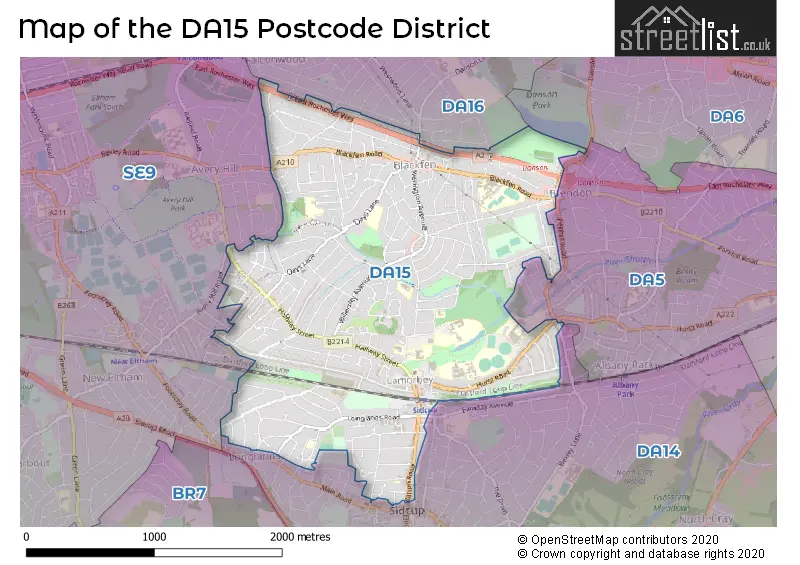
The DA15 Postcode shares a border with SE9 (ELTHAM, MOTTINGHAM), DA5 (BEXLEY), DA14 (SIDCUP) and DA16 (WELLING).
The primary settlement in the DA15 postcode district is Sidcup, a town located in Greater London.
For the district DA15, we have data on 4 postcode sectors. Here's a breakdown: The sector DA15 0 is non-geographic. It's often designated for PO Boxes, large organisations, or special services. The sector DA15 7, covers Sidcup in Greater London. The sector DA15 8, covers Sidcup in Greater London. The sector DA15 9, covers Sidcup in Greater London.


Map of the DA15 Postcode District
Explore the DA15 postcode district by using our free interactive map.
When it comes to local government, postal geography often disregards political borders. However, for a breakdown in the DA15 District: the district mostly encompasses the Bexley London Boro (491 postcodes), and finally, the Greenwich London Boro area (14 postcodes).
Weather Forecast for DA15
Press Button to Show Forecast for Bexley
| Time Period | Icon | Description | Temperature | Rain Probability | Wind |
|---|---|---|---|---|---|
| 09:00 to 12:00 | Overcast | 8.0°C (feels like 6.0°C) | 15.00% | NE 9 mph | |
| 12:00 to 15:00 | Light rain | 11.0°C (feels like 10.0°C) | 51.00% | ENE 7 mph | |
| 15:00 to 18:00 | Cloudy | 12.0°C (feels like 11.0°C) | 50.00% | NE 7 mph | |
| 18:00 to 21:00 | Light rain | 11.0°C (feels like 9.0°C) | 52.00% | ENE 9 mph | |
| 21:00 to 00:00 | Heavy rain | 10.0°C (feels like 7.0°C) | 88.00% | NE 9 mph |
Press Button to Show Forecast for Bexley
| Time Period | Icon | Description | Temperature | Rain Probability | Wind |
|---|---|---|---|---|---|
| 00:00 to 03:00 | Heavy rain | 9.0°C (feels like 7.0°C) | 90.00% | NE 9 mph | |
| 03:00 to 06:00 | Heavy rain | 9.0°C (feels like 7.0°C) | 89.00% | NNE 7 mph | |
| 06:00 to 09:00 | Heavy rain | 9.0°C (feels like 8.0°C) | 86.00% | ESE 7 mph | |
| 09:00 to 12:00 | Heavy rain | 10.0°C (feels like 8.0°C) | 80.00% | WNW 9 mph | |
| 12:00 to 15:00 | Light rain shower (day) | 10.0°C (feels like 8.0°C) | 44.00% | W 13 mph | |
| 15:00 to 18:00 | Light rain | 11.0°C (feels like 8.0°C) | 49.00% | W 11 mph | |
| 18:00 to 21:00 | Cloudy | 11.0°C (feels like 9.0°C) | 11.00% | WSW 9 mph | |
| 21:00 to 00:00 | Partly cloudy (night) | 9.0°C (feels like 7.0°C) | 4.00% | SW 7 mph |
Press Button to Show Forecast for Bexley
| Time Period | Icon | Description | Temperature | Rain Probability | Wind |
|---|---|---|---|---|---|
| 00:00 to 03:00 | Clear night | 8.0°C (feels like 6.0°C) | 2.00% | SW 7 mph | |
| 03:00 to 06:00 | Clear night | 7.0°C (feels like 5.0°C) | 1.00% | SSW 4 mph | |
| 06:00 to 09:00 | Sunny day | 7.0°C (feels like 6.0°C) | 1.00% | S 4 mph | |
| 09:00 to 12:00 | Partly cloudy (day) | 12.0°C (feels like 10.0°C) | 3.00% | S 9 mph | |
| 12:00 to 15:00 | Cloudy | 14.0°C (feels like 12.0°C) | 5.00% | S 11 mph | |
| 15:00 to 18:00 | Cloudy | 15.0°C (feels like 13.0°C) | 5.00% | S 11 mph | |
| 18:00 to 21:00 | Sunny day | 14.0°C (feels like 12.0°C) | 2.00% | S 7 mph | |
| 21:00 to 00:00 | Clear night | 10.0°C (feels like 9.0°C) | 1.00% | SSE 7 mph |
Press Button to Show Forecast for Bexley
| Time Period | Icon | Description | Temperature | Rain Probability | Wind |
|---|---|---|---|---|---|
| 00:00 to 03:00 | Clear night | 9.0°C (feels like 8.0°C) | 2.00% | SE 7 mph | |
| 03:00 to 06:00 | Clear night | 8.0°C (feels like 7.0°C) | 3.00% | ESE 7 mph | |
| 06:00 to 09:00 | Cloudy | 9.0°C (feels like 8.0°C) | 9.00% | ESE 7 mph | |
| 09:00 to 12:00 | Partly cloudy (day) | 13.0°C (feels like 12.0°C) | 5.00% | ESE 7 mph | |
| 12:00 to 15:00 | Cloudy | 16.0°C (feels like 14.0°C) | 12.00% | SE 9 mph | |
| 15:00 to 18:00 | Cloudy | 16.0°C (feels like 15.0°C) | 13.00% | SE 9 mph | |
| 18:00 to 21:00 | Cloudy | 15.0°C (feels like 14.0°C) | 12.00% | ESE 9 mph | |
| 21:00 to 00:00 | Light rain shower (night) | 13.0°C (feels like 12.0°C) | 38.00% | ESE 7 mph |
Where is the DA15 Postcode District?
The DA15 postcode district is located in Sidcup, which is a town in London. It is situated approximately 10.79 miles away from the center of London. Sidcup is surrounded by several nearby towns including Avery Hill to the West, New Eltham to the South West, Welling to the North, Bexley to the East, Scadbury to the South, and Bexleyheath to the North East.
The district is within the post town of SIDCUP.
The sector has postcodes within the nation of England.
The DA15 Postcode District is in the Bexley and Greenwich region of Outer London - East and North East within the London.
| Postcode Sector | Delivery Office |
|---|---|
| DA15 7 | Sidcup Delivery Office |
| DA15 8 | Sidcup Delivery Office |
| DA15 9 | Sidcup Delivery Office |
| D | A | 1 | 5 | - | X | X | X |
| D | A | 1 | 5 | Space | Numeric | Letter | Letter |
Current Monthly Rental Prices
| # Bedrooms | Min Price | Max Price | Avg Price |
|---|---|---|---|
| £1,300 | £1,300 | £1,300 | |
| 1 | £1,100 | £1,400 | £1,270 |
| 2 | £1,400 | £1,550 | £1,500 |
| 3 | £1,850 | £2,300 | £2,038 |
| 4 | £2,400 | £2,800 | £2,533 |
Current House Prices
| # Bedrooms | Min Price | Max Price | Avg Price |
|---|---|---|---|
| £210,000 | £650,000 | £371,000 | |
| 1 | £115,000 | £380,000 | £228,750 |
| 2 | £250,000 | £500,000 | £406,071 |
| 3 | £225,000 | £750,000 | £510,227 |
| 4 | £475,000 | £1,200,000 | £722,258 |
| 5 | £535,000 | £1,350,000 | £839,000 |
| 6 | £600,000 | £750,000 | £675,000 |
| 7 | £850,000 | £850,000 | £850,000 |
Estate Agents who Operate in the DA15 District
| Logo | Name | Brand Name | Address | Contact Number | Total Properties |
|---|---|---|---|---|---|
 | Sidcup, The Oval | Christopher Russell | 33 The Oval, Sidcup, DA15 9ER | 020 3840 3340 | 30 |
 | Sidcup | Robinson Jackson | 1 Wellington Parade, Blackfen Road, Sidcup, DA15 9NB | 020 3909 9660 | 23 |
 | Blackfen | Acorn | 258 Blackfen Road, Sidcup, DA15 8PW | 020 3840 3745 | 21 |
 | Sidcup | Village Estates | 93 Main Road, Sidcup, DA14 6ND | 020 3909 6658 | 17 |
 | Sidcup | Drewery Property Services | 128 Station Road, Sidcup, DA15 7AF | 020 3835 6094 | 11 |
| Type of Property | 2018 Average | 2018 Sales | 2017 Average | 2017 Sales | 2016 Average | 2016 Sales | 2015 Average | 2015 Sales |
|---|---|---|---|---|---|---|---|---|
| Detached | £606,545 | 22 | £698,536 | 28 | £647,528 | 36 | £606,651 | 38 |
| Semi-Detached | £467,897 | 158 | £471,571 | 162 | £435,134 | 131 | £398,901 | 139 |
| Terraced | £367,527 | 190 | £364,643 | 171 | £346,796 | 204 | £316,698 | 197 |
| Flats | £249,254 | 55 | £257,387 | 62 | £242,136 | 112 | £191,410 | 91 |