The DE56 2 postcode sector is within the county of Derbyshire.
Did you know? According to the 2021 Census, the DE56 2 postcode sector is home to a bustling 8,637 residents!
Given that each sector allows for 400 unique postcode combinations. Letters C, I, K, M, O and V are not allowed in the last two letters of a postcode. With 227 postcodes already in use, this leaves 173 units available.
The largest settlement in the DE56 2 postal code is BELPER followed by Ambergate, and Heage.
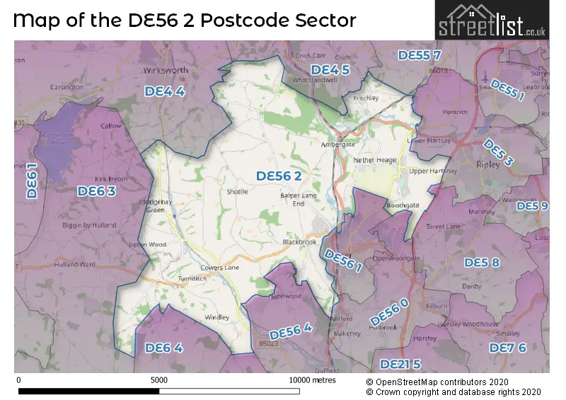
The DE56 2 Postcode shares a border with DE4 4 (Wirksworth, Brassington, Middleton), DE4 5 (Crich, Tansley, Whatstandwell), DE5 3 (RIPLEY, Pentrich, Butterley), DE6 3 (Brailsford, Hulland Ward, Kirk Ireton), DE6 4 (Kirk Langley, Radbourne, Weston Underwood), DE22 5 (Quarndon), DE55 7 (ALFRETON, South Wingfield, Oakerthorpe), DE56 0 (BELPER, Kilburn, Milford), DE5 8 (Marehay, Denby, Denby Village), DE56 1 (BELPER) and DE56 4 (Duffield, Hazelwood).
The sector is within the post town of BELPER.
DE56 2 is a postcode sector within the DE56 postcode district which is within the DE Derby postcode area.
The Royal Mail delivery office for the DE56 2 postal sector is the Belper Delivery Office.
The area of the DE56 2 postcode sector is 24.84 square miles which is 64.34 square kilometres or 15,899.44 square acres.
The DE56 2 postcode sector is crossed by the A38 Major A road.
Waterways within the DE56 2 postcode sector include the River Ecclesbourne, Ecclesbourne, River Derwent, Sherbourne Brook, Ecclesbourne; River Ecclesbourne, River Amber, Cromford Canal.

Map of the DE56 2 Postcode Sector
Explore the DE56 2 postcode sector by using our free interactive map.
| D | E | 5 | 6 | - | 2 | X | X |
| D | E | 5 | 6 | Space | 2 | Letter | Letter |
Official List of Streets
Fritchley (21 Streets)
Ambergate (42 Streets)
BELPER (37 Streets)
Blackbrook (2 Streets)
Cowers Lane (2 Streets)
Shottle Gate (3 Streets)
Turnditch (11 Streets)
Heage (33 Streets)
Nether Heage (16 Streets)
Shottle (3 Streets)
Milford (1 Streets)
Idridgehay (6 Streets)
Windley (2 Streets)
Unofficial Streets or Alternative Spellings
RIPLEY
HEAGE ROAD ALLAN LANE ALPORT LANE AMBER GROVE BACK LANE BACK WYVER LANE BANK SIDE BARNSLEY LANE BELPER ROAD BOBBINMILL HILL BOMANS LANE BRIARS LANE BRICKYARD ROAD BROOK LANE BURY HILL CHAPEL HILL CHEQUER LANE CRICH ROAD CRICH VIEW CROMFORD CANAL DERBY OLD ROAD DUNGLEY HILL ECCLESBOURNE LANE FARNAH GREEN ROAD HAG LANE HAGG LANE HEAVYGATE LANE HIGG LANE HOLLY HOUSE LANE HULLAND WARD FP 10 JACKASS LANE JEBBS LANE JOHNSON LANE LITTLE HAYES LODGE LANE LONGWALLS LANE LUMB LANE MAG LANE MEADOW DRIVE MORLEY PARK ROAD MOUNT PLEASENT DRIVE NARROW LANE NODIN HILL LANE OLD HILLCLIFF LANE OLD LANE PALACE LANE PALEROW LANE PEAT LANE PENDLETON LANE ROOKERY FARM LANE ROUGHPIECE LANE SANDHALL LANE SANDYFORD LANE SHAWS HILL SMITH-HALL LANE SPOUT LANE STATION APPROACH TANGLEWOOD THE DRIVE TOP LANE TOWNHEAD WELL LANE WHITEWELLS ROAD WILDERBROOK LANE WINDMILL LANE WOOD LANEBELPER
OVER LANELower Hartshay
BRIDLE LANESawmills
CANAL CLOSECrich
CHADWICK NICK LANE DIMPLE LANE THE COMMONHazelwood
FIRESTONE LUMB LANE OVER LANEWeston Underwood
BULLHURST LANEWirksworth
BENT LANE DERBY ROADMercaston
MERCASTON LANEWeather Forecast for DE56 2
Press Button to Show Forecast for Belper River Gardens
| Time Period | Icon | Description | Temperature | Rain Probability | Wind |
|---|---|---|---|---|---|
| 21:00 to 00:00 | Cloudy | 6.0°C (feels like 4.0°C) | 6.00% | ENE 7 mph |
Press Button to Show Forecast for Belper River Gardens
| Time Period | Icon | Description | Temperature | Rain Probability | Wind |
|---|---|---|---|---|---|
| 00:00 to 03:00 | Cloudy | 5.0°C (feels like 3.0°C) | 6.00% | NE 7 mph | |
| 03:00 to 06:00 | Cloudy | 4.0°C (feels like 2.0°C) | 6.00% | NE 7 mph | |
| 06:00 to 09:00 | Cloudy | 5.0°C (feels like 2.0°C) | 6.00% | NE 9 mph | |
| 09:00 to 12:00 | Cloudy | 8.0°C (feels like 5.0°C) | 15.00% | NE 11 mph | |
| 12:00 to 15:00 | Light rain | 8.0°C (feels like 6.0°C) | 55.00% | ENE 9 mph | |
| 15:00 to 18:00 | Overcast | 8.0°C (feels like 6.0°C) | 15.00% | ENE 9 mph | |
| 18:00 to 21:00 | Overcast | 8.0°C (feels like 5.0°C) | 18.00% | NE 9 mph | |
| 21:00 to 00:00 | Overcast | 7.0°C (feels like 4.0°C) | 12.00% | NE 9 mph |
Press Button to Show Forecast for Belper River Gardens
| Time Period | Icon | Description | Temperature | Rain Probability | Wind |
|---|---|---|---|---|---|
| 00:00 to 03:00 | Cloudy | 6.0°C (feels like 3.0°C) | 16.00% | NNE 11 mph | |
| 03:00 to 06:00 | Light rain | 6.0°C (feels like 2.0°C) | 48.00% | NNE 13 mph | |
| 06:00 to 09:00 | Heavy rain | 6.0°C (feels like 2.0°C) | 77.00% | N 13 mph | |
| 09:00 to 12:00 | Heavy rain | 7.0°C (feels like 3.0°C) | 78.00% | NNW 11 mph | |
| 12:00 to 15:00 | Light rain | 8.0°C (feels like 6.0°C) | 54.00% | NW 11 mph | |
| 15:00 to 18:00 | Light rain shower (day) | 10.0°C (feels like 8.0°C) | 35.00% | WNW 9 mph | |
| 18:00 to 21:00 | Partly cloudy (day) | 10.0°C (feels like 8.0°C) | 7.00% | W 9 mph | |
| 21:00 to 00:00 | Clear night | 7.0°C (feels like 5.0°C) | 4.00% | WSW 7 mph |
Press Button to Show Forecast for Belper River Gardens
| Time Period | Icon | Description | Temperature | Rain Probability | Wind |
|---|---|---|---|---|---|
| 00:00 to 03:00 | Clear night | 5.0°C (feels like 3.0°C) | 1.00% | SW 4 mph | |
| 03:00 to 06:00 | Clear night | 4.0°C (feels like 1.0°C) | 0.00% | SSW 7 mph | |
| 06:00 to 09:00 | Sunny day | 5.0°C (feels like 3.0°C) | 2.00% | SSW 7 mph | |
| 09:00 to 12:00 | Sunny day | 10.0°C (feels like 8.0°C) | 1.00% | S 11 mph | |
| 12:00 to 15:00 | Overcast | 13.0°C (feels like 10.0°C) | 9.00% | S 13 mph | |
| 15:00 to 18:00 | Cloudy | 14.0°C (feels like 11.0°C) | 7.00% | S 13 mph | |
| 18:00 to 21:00 | Partly cloudy (day) | 13.0°C (feels like 11.0°C) | 3.00% | S 11 mph | |
| 21:00 to 00:00 | Clear night | 10.0°C (feels like 8.0°C) | 2.00% | SSE 9 mph |
Press Button to Show Forecast for Belper River Gardens
| Time Period | Icon | Description | Temperature | Rain Probability | Wind |
|---|---|---|---|---|---|
| 00:00 to 03:00 | Clear night | 8.0°C (feels like 6.0°C) | 2.00% | SE 7 mph | |
| 03:00 to 06:00 | Clear night | 7.0°C (feels like 5.0°C) | 2.00% | ESE 7 mph | |
| 06:00 to 09:00 | Partly cloudy (day) | 8.0°C (feels like 5.0°C) | 4.00% | ESE 7 mph | |
| 09:00 to 12:00 | Partly cloudy (day) | 12.0°C (feels like 10.0°C) | 5.00% | ESE 9 mph | |
| 12:00 to 15:00 | Cloudy | 15.0°C (feels like 13.0°C) | 10.00% | SE 11 mph | |
| 15:00 to 18:00 | Partly cloudy (day) | 16.0°C (feels like 14.0°C) | 9.00% | SE 11 mph | |
| 18:00 to 21:00 | Cloudy | 15.0°C (feels like 13.0°C) | 10.00% | ESE 9 mph | |
| 21:00 to 00:00 | Cloudy | 12.0°C (feels like 10.0°C) | 9.00% | E 9 mph |
Schools and Places of Education Within the DE56 2 Postcode Sector
Alderwasley Hall School
Other independent special school
Higg Lane, Derbyshire, , DE56 2SR
Head: Ms Sara Forsyth
Ofsted Rating: Outstanding
Inspection: 2022-07-14 (652 days ago)
Website: Visit Alderwasley Hall School Website
Phone: 01629822586
Number of Pupils: 123
Ambergate Primary School
Community school
Toadmoor Lane, Belper, Derbyshire, DE56 2GN
Head: Mrs Carly Howell
Ofsted Rating: Good
Inspection: 2022-03-16 (772 days ago)
Website: Visit Ambergate Primary School Website
Phone: 01773852204
Number of Pupils: 79
Fritchley CofE (Aided) Primary & Nursery School
Voluntary aided school
Church Street, Belper, Derbyshire, DE56 2FQ
Head: Mrs Rosie Turner
Ofsted Rating: Good
Inspection: 2018-12-12 (1962 days ago)
Website: Visit Fritchley CofE (Aided) Primary & Nursery School Website
Phone: 01773852216
Number of Pupils: 87
Heage Primary School
Community school
School Lane, Belper, Derbyshire, DE56 2AL
Head: Mrs Donna Hallam
Ofsted Rating: Good
Inspection: 2021-12-08 (870 days ago)
Website: Visit Heage Primary School Website
Phone: 01773852188
Number of Pupils: 173
Turnditch Church of England Primary School
Academy converter
Ashbourne Road, Belper, Derbyshire, DE56 2LH
Head: Mr David Brown
Ofsted Rating: Good
Inspection: 2020-01-22 (1556 days ago)
Website: Visit Turnditch Church of England Primary School Website
Phone: 01773550304
Number of Pupils: 82
House Prices in the DE56 2 Postcode Sector
| Type of Property | 2018 Average | 2018 Sales | 2017 Average | 2017 Sales | 2016 Average | 2016 Sales | 2015 Average | 2015 Sales |
|---|---|---|---|---|---|---|---|---|
| Detached | £350,355 | 77 | £340,943 | 64 | £284,299 | 73 | £312,820 | 94 |
| Semi-Detached | £219,219 | 51 | £182,414 | 50 | £184,499 | 40 | £178,975 | 40 |
| Terraced | £217,857 | 14 | £150,768 | 28 | £150,039 | 34 | £159,111 | 19 |
| Flats | £180,000 | 1 | £180,000 | 1 | £0 | 0 | £0 | 0 |
Important Postcodes DE56 2 in the Postcode Sector
DE56 2AL is the postcode for INFANT BLOCK, Heage Primary School, School Lane, and OLD SCHOOL HOUSE, Heage Primary School, School Lane
DE56 2ER is the postcode for Whole Building, Ambergate Workshop & Laboratory, Ripley Road, AMBERGATE WORKSHOP & LABORATORY, Derbyshire County Council, Ripley Road, Whole Building, Ambergate Workshop & Laboratory, Ripely Road, Derbyshire County Council, Ripley Road, and Workshop & Laboratory, Derbyshire County Council, Ripley Road
DE56 2FQ is the postcode for Fritchley C of E Aided Primary School, Church Street
DE56 2GN is the postcode for Ambergate Primary School, Toadmoor Lane
DE56 2JD is the postcode for St. Elizabeths Catholic Primary School, Matlock Road
| The DE56 2 Sector is within these Local Authorities |
|
|---|---|
| The DE56 2 Sector is within these Counties |
|
| The DE56 2 Sector is within these Water Company Areas |
|
Tourist Attractions within the DE56 2 Postcode Area
We found 1 visitor attractions within the DE56 postcode area
| Heage Windmill |
|---|
| Visitor Centres |
| Heritage / Visitor Centre |
| View Heage Windmill on Google Maps |