The DH7 postcode district is a postal district located in the DH Durham postcode area with a population of 42,740 residents according to the 2021 England and Wales Census.
The area of the DH7 postcode district is 49.90 square miles which is 129.25 square kilometres or 31,938.15 acres.
Currently, the DH7 district has about 1246 postcode units spread across 5 geographic postcode sectors.
Given that each sector allows for 400 unique postcode combinations, the district has a capacity of 2,000 postcodes. With 1246 postcodes already in use, this leaves 754 units available.
The largest settlement in the DH7 postal code is Sacriston followed by Brandon, and Ushaw Moor.
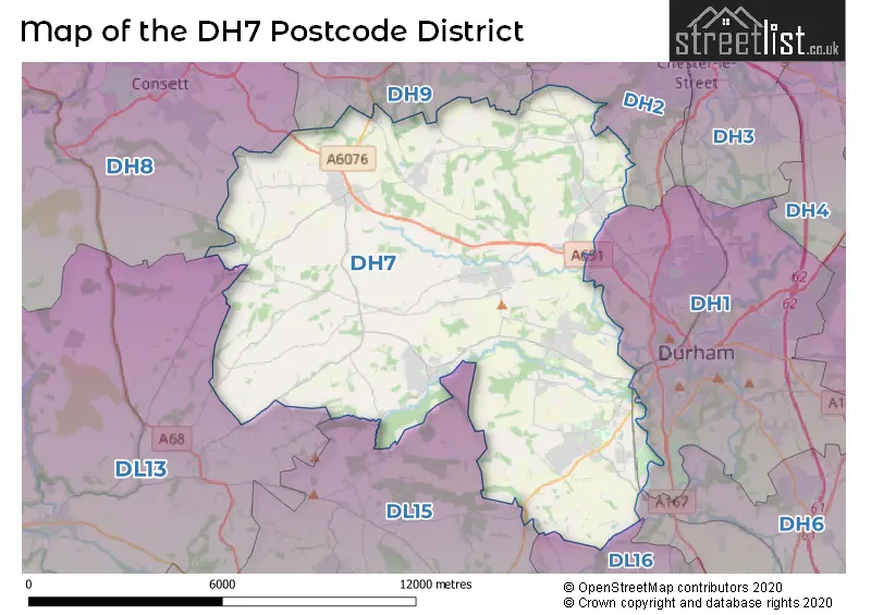
The DH7 Postcode shares a border with DH8 (CONSETT, Blackhill, Leadgate), DL15 (CROOK, Willington, Howden Le Wear), DH1 (DURHAM, Pity Me, High Shincliffe), DL16 (SPENNYMOOR, Kirk Merrington, Byers Green), DH2 (CHESTER LE STREET, Pelton, Ouston), DH9 (STANLEY, Dipton, Tanfield Lea) and DL13 (Tow Law, Wolsingham, Stanhope).
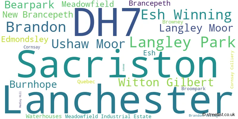
The primary settlement in the DH7 postcode district is Durham, located in the county of Durham in England. Other significant settlements within this postcode district include Lanchester, Sacriston, Witton Gilbert, Bearpark, New Brancepeth, Ushaw Moor, Brandon, Langley Moor, Meadowfield, Esh Winning, and Langley Park. The most significant post town in this district is Durham.
For the district DH7, we have data on 5 postcode sectors. Here's a breakdown: The sector DH7 0, covers Lanchester and Burnhope in Durham. The sector DH7 6, covers Sacriston and Witton Gilbert and Edmondsley in Durham. The sector DH7 7, covers Ushaw Moor and Bearpark and New Brancepeth in Durham. The sector DH7 8, covers Brandon and Langley Moor and Meadowfield and Brancepeth in Durham. The sector DH7 9, covers Langley Park and Esh Winning in Durham.

Map of the DH7 Postcode District
Explore the DH7 postcode district by using our free interactive map.
When it comes to local government, postal geography often disregards political borders. However, for a breakdown in the DH7 District: the district mostly encompasses the County Durham area with a total of 1255 postcodes.
Weather Forecast for DH7
Press Button to Show Forecast for Lanchester
| Time Period | Icon | Description | Temperature | Rain Probability | Wind |
|---|---|---|---|---|---|
| 09:00 to 12:00 | Cloudy | 7.0°C (feels like 5.0°C) | 6.00% | ENE 7 mph | |
| 12:00 to 15:00 | Cloudy | 9.0°C (feels like 7.0°C) | 8.00% | ENE 9 mph | |
| 15:00 to 18:00 | Overcast | 8.0°C (feels like 6.0°C) | 9.00% | ENE 9 mph | |
| 18:00 to 21:00 | Cloudy | 7.0°C (feels like 5.0°C) | 7.00% | ENE 9 mph | |
| 21:00 to 00:00 | Cloudy | 5.0°C (feels like 3.0°C) | 8.00% | NE 4 mph |
Press Button to Show Forecast for Lanchester
| Time Period | Icon | Description | Temperature | Rain Probability | Wind |
|---|---|---|---|---|---|
| 00:00 to 03:00 | Cloudy | 4.0°C (feels like 2.0°C) | 5.00% | NNE 4 mph | |
| 03:00 to 06:00 | Cloudy | 5.0°C (feels like 2.0°C) | 6.00% | N 7 mph | |
| 06:00 to 09:00 | Cloudy | 5.0°C (feels like 2.0°C) | 10.00% | N 9 mph | |
| 09:00 to 12:00 | Light rain | 7.0°C (feels like 3.0°C) | 49.00% | N 13 mph | |
| 12:00 to 15:00 | Light rain | 8.0°C (feels like 5.0°C) | 49.00% | NNW 11 mph | |
| 15:00 to 18:00 | Light rain | 9.0°C (feels like 6.0°C) | 45.00% | NW 11 mph | |
| 18:00 to 21:00 | Sunny day | 9.0°C (feels like 8.0°C) | 8.00% | WNW 7 mph | |
| 21:00 to 00:00 | Clear night | 6.0°C (feels like 3.0°C) | 1.00% | SW 9 mph |
Press Button to Show Forecast for Lanchester
| Time Period | Icon | Description | Temperature | Rain Probability | Wind |
|---|---|---|---|---|---|
| 00:00 to 03:00 | Clear night | 5.0°C (feels like 2.0°C) | 1.00% | SW 7 mph | |
| 03:00 to 06:00 | Clear night | 4.0°C (feels like 1.0°C) | 1.00% | SSW 7 mph | |
| 06:00 to 09:00 | Sunny day | 5.0°C (feels like 2.0°C) | 2.00% | S 9 mph | |
| 09:00 to 12:00 | Partly cloudy (day) | 10.0°C (feels like 7.0°C) | 2.00% | S 13 mph | |
| 12:00 to 15:00 | Cloudy | 13.0°C (feels like 10.0°C) | 6.00% | S 16 mph | |
| 15:00 to 18:00 | Cloudy | 13.0°C (feels like 10.0°C) | 6.00% | S 13 mph | |
| 18:00 to 21:00 | Partly cloudy (day) | 12.0°C (feels like 10.0°C) | 6.00% | S 11 mph | |
| 21:00 to 00:00 | Partly cloudy (night) | 10.0°C (feels like 7.0°C) | 4.00% | SSE 9 mph |
Press Button to Show Forecast for Lanchester
| Time Period | Icon | Description | Temperature | Rain Probability | Wind |
|---|---|---|---|---|---|
| 00:00 to 03:00 | Partly cloudy (night) | 8.0°C (feels like 6.0°C) | 1.00% | SSE 9 mph | |
| 03:00 to 06:00 | Clear night | 6.0°C (feels like 3.0°C) | 1.00% | SE 7 mph | |
| 06:00 to 09:00 | Sunny day | 7.0°C (feels like 5.0°C) | 2.00% | SE 7 mph | |
| 09:00 to 12:00 | Partly cloudy (day) | 11.0°C (feels like 10.0°C) | 7.00% | ESE 9 mph | |
| 12:00 to 15:00 | Cloudy | 14.0°C (feels like 11.0°C) | 16.00% | ESE 11 mph | |
| 15:00 to 18:00 | Cloudy | 14.0°C (feels like 11.0°C) | 13.00% | E 11 mph | |
| 18:00 to 21:00 | Cloudy | 12.0°C (feels like 10.0°C) | 9.00% | E 9 mph | |
| 21:00 to 00:00 | Overcast | 10.0°C (feels like 8.0°C) | 16.00% | ENE 7 mph |
Where is the DH7 Postcode District?
The DH7 postcode district is located in Durham. It is surrounded by several nearby towns such as Stanley to the North (approx. 5.12 miles away), Crook to the South (approx. 5.38 miles away), Chester Le Street to the North East (approx. 6.50 miles away), Spenney moor to the South East (approx. 7.71 miles away), and Consett to the North West (approx. 7.85 miles away). Additionally, the DH7 postcode district is approximately 236.31 miles away from the center of London.
The district is within the post town of DURHAM.
The sector has postcodes within the nation of England.
The DH7 Postcode District is in the Durham CC region of Tees Valley and Durham within the North East (England).
| Postcode Sector | Delivery Office |
|---|---|
| DH7 0 | Durham Delivery Office |
| DH7 0 | Derwentside Delivery Office |
| DH7 6 | Durham Delivery Office |
| DH7 7 | Durham Delivery Office |
| DH7 8 | Durham Delivery Office |
| DH7 9 | Durham Delivery Office |
| D | H | 7 | - | X | X | X |
| D | H | 7 | Space | Numeric | Letter | Letter |
Tourist Attractions within the Postcode Area
We found 1 visitor attractions within the DH7 postcode area
| Stoneacre |
|---|
| Historic Properties |
| Historic House / House and Garden / Palace |
| View Stoneacre on Google Maps |
Current Monthly Rental Prices
| # Bedrooms | Min Price | Max Price | Avg Price |
|---|---|---|---|
| 1 | £425 | £475 | £450 |
| 2 | £475 | £950 | £639 |
| 3 | £477 | £1,575 | £731 |
| 4 | £1,250 | £1,250 | £1,250 |
| 17 | £6,250 | £6,250 | £6,250 |
Current House Prices
| # Bedrooms | Min Price | Max Price | Avg Price |
|---|---|---|---|
| £50,000 | £580,000 | £190,938 | |
| 2 | £41,000 | £349,950 | £120,931 |
| 3 | £45,000 | £1,200,000 | £186,415 |
| 4 | £127,250 | £1,500,000 | £338,018 |
| 5 | £190,000 | £1,750,000 | £642,355 |
| 6 | £200,000 | £1,190,000 | £605,000 |
Estate Agents who Operate in the DH7 District
| Logo | Name | Brand Name | Address | Contact Number | Total Properties |
|---|---|---|---|---|---|
 | Durham City | J W Wood | 7 Old Elvet, Durham City, DH1 3HL | 0191 625 1013 | 23 |
 | Durham | Robinsons | 1&2 Old Elvet, Durham, DH1 3HL | 0191 625 0108 | 23 |
 | Durham | Dowen | 3B, Old Elvet, Durham City, DH1 3HL | 0191 625 0869 | 20 |
 | Durham | Ben Charles | 96 Claypath, Durham, DH1 1RG | 0191 607 1343 | 16 |
 | Durham City | Reeds Rains | 83 New Elvet Durham DH1 3AQ | 0191 625 0250 | 14 |
- Bearpark
- Brancepeth
- Brandon
- Broompark
- Burnhope
- Consett
- Cornsay
- Craghead
- Durham
- East Butsfield
- East Hedleyhope
- Edmondsley
- Esh
- Esh Winning
- Holmside
- Lanchester
- Langley Moor
- Langley Park
- Maiden Law
- Meadowfield
- New Brancepeth
- Quebec
- Sacriston
- Satley
- Spennymoor
- Tow Law
- Ushaw Moor
- Waterhouses
- Witton Gilbert
| Type of Property | 2018 Average | 2018 Sales | 2017 Average | 2017 Sales | 2016 Average | 2016 Sales | 2015 Average | 2015 Sales |
|---|---|---|---|---|---|---|---|---|
| Detached | £228,593 | 209 | £215,241 | 224 | £208,584 | 168 | £207,433 | 140 |
| Semi-Detached | £109,684 | 229 | £102,207 | 239 | £112,915 | 209 | £101,173 | 227 |
| Terraced | £83,909 | 273 | £87,190 | 291 | £85,346 | 251 | £90,054 | 237 |
| Flats | £86,850 | 10 | £85,837 | 15 | £129,020 | 22 | £76,935 | 13 |