The DH7 8 postcode sector is within the county of Durham.
Did you know? According to the 2021 Census, the DH7 8 postcode sector is home to a bustling 10,521 residents!
Given that each sector allows for 400 unique postcode combinations. Letters C, I, K, M, O and V are not allowed in the last two letters of a postcode. With 271 postcodes already in use, this leaves 129 units available.
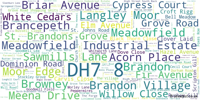
The largest settlement in the DH7 8 postal code is Brandon followed by Langley Moor, and Meadowfield.
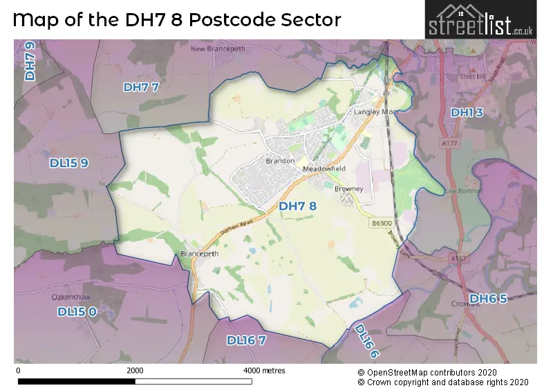
The DH7 8 Postcode shares a border with DH1 3 (DURHAM, Houghall, Stonebridge), DH6 5 (Bowburn, Croxdale, Tursdale), DL15 9 (CROOK, Stanley, Billy Row), DL16 6 (SPENNYMOOR, Tudhoe Colliery, Tudhoe Village), DL16 7 (SPENNYMOOR, Kirk Merrington, Byers Green), DH7 7 (Ushaw Moor, Bearpark, New Brancepeth) and DL15 0 (Willington, Hunwick, Sunnybrow).
The sector is within the post town of DURHAM.
DH7 8 is a postcode sector within the DH7 postcode district which is within the DH Durham postcode area.
The Royal Mail delivery office for the DH7 8 postal sector is the Durham Delivery Office.
The area of the DH7 8 postcode sector is 7.16 square miles which is 18.56 square kilometres or 4,585.15 square acres.
Waterways within the DH7 8 postcode sector include the River Browney, Wear, River Deerness.

Map of the DH7 8 Postcode Sector
Explore the DH7 8 postcode sector by using our free interactive map.
| D | H | 7 | - | 8 | X | X |
| D | H | 7 | Space | 8 | Letter | Letter |
Official List of Streets
Brandon (81 Streets)
Meadowfield (30 Streets)
Langley Moor (39 Streets)
Meadowfield Industrial Estate (5 Streets)
Browney (10 Streets)
Brancepeth (12 Streets)
Brandon Village (4 Streets)
Unofficial Streets or Alternative Spellings
Langley Moor
HIGH STREET SOUTH BACKBrandon
SILVER COURTSOakenshaw
STOCKLEY LANEStanley
WOLSINGHAM ROADWeather Forecast for DH7 8
Press Button to Show Forecast for Brandon (Durham)
| Time Period | Icon | Description | Temperature | Rain Probability | Wind |
|---|---|---|---|---|---|
| 18:00 to 21:00 | Cloudy | 19.0°C (feels like 17.0°C) | 4.00% | SSE 11 mph | |
| 21:00 to 00:00 | Cloudy | 16.0°C (feels like 15.0°C) | 5.00% | SSE 9 mph |
Press Button to Show Forecast for Brandon (Durham)
| Time Period | Icon | Description | Temperature | Rain Probability | Wind |
|---|---|---|---|---|---|
| 00:00 to 03:00 | Partly cloudy (night) | 15.0°C (feels like 14.0°C) | 1.00% | SSE 7 mph | |
| 03:00 to 06:00 | Cloudy | 14.0°C (feels like 13.0°C) | 12.00% | SE 7 mph | |
| 06:00 to 09:00 | Heavy rain | 13.0°C (feels like 12.0°C) | 88.00% | E 7 mph | |
| 09:00 to 12:00 | Heavy rain | 14.0°C (feels like 13.0°C) | 90.00% | ENE 7 mph | |
| 12:00 to 15:00 | Heavy rain | 14.0°C (feels like 13.0°C) | 87.00% | ENE 9 mph | |
| 15:00 to 18:00 | Light rain | 15.0°C (feels like 14.0°C) | 58.00% | ESE 9 mph | |
| 18:00 to 21:00 | Light rain | 15.0°C (feels like 14.0°C) | 56.00% | SE 7 mph | |
| 21:00 to 00:00 | Cloudy | 14.0°C (feels like 13.0°C) | 12.00% | SSE 4 mph |
Press Button to Show Forecast for Brandon (Durham)
| Time Period | Icon | Description | Temperature | Rain Probability | Wind |
|---|---|---|---|---|---|
| 00:00 to 03:00 | Cloudy | 13.0°C (feels like 12.0°C) | 12.00% | SSE 4 mph | |
| 03:00 to 06:00 | Cloudy | 12.0°C (feels like 11.0°C) | 8.00% | SE 4 mph | |
| 06:00 to 09:00 | Cloudy | 13.0°C (feels like 12.0°C) | 10.00% | SE 4 mph | |
| 09:00 to 12:00 | Cloudy | 15.0°C (feels like 15.0°C) | 13.00% | E 4 mph | |
| 12:00 to 15:00 | Light rain shower (day) | 15.0°C (feels like 14.0°C) | 36.00% | ENE 7 mph | |
| 15:00 to 18:00 | Cloudy | 16.0°C (feels like 15.0°C) | 12.00% | ENE 7 mph | |
| 18:00 to 21:00 | Cloudy | 15.0°C (feels like 14.0°C) | 10.00% | ENE 4 mph | |
| 21:00 to 00:00 | Partly cloudy (night) | 12.0°C (feels like 11.0°C) | 2.00% | ENE 4 mph |
Press Button to Show Forecast for Brandon (Durham)
| Time Period | Icon | Description | Temperature | Rain Probability | Wind |
|---|---|---|---|---|---|
| 00:00 to 03:00 | Mist | 11.0°C (feels like 10.0°C) | 14.00% | NE 4 mph | |
| 03:00 to 06:00 | Mist | 10.0°C (feels like 10.0°C) | 15.00% | WNW 4 mph | |
| 06:00 to 09:00 | Cloudy | 12.0°C (feels like 11.0°C) | 7.00% | W 4 mph | |
| 09:00 to 12:00 | Cloudy | 15.0°C (feels like 14.0°C) | 11.00% | NW 4 mph | |
| 12:00 to 15:00 | Partly cloudy (day) | 17.0°C (feels like 16.0°C) | 8.00% | ENE 7 mph | |
| 15:00 to 18:00 | Partly cloudy (day) | 17.0°C (feels like 16.0°C) | 8.00% | NE 9 mph | |
| 18:00 to 21:00 | Partly cloudy (day) | 15.0°C (feels like 14.0°C) | 8.00% | NNW 7 mph | |
| 21:00 to 00:00 | Partly cloudy (night) | 12.0°C (feels like 11.0°C) | 4.00% | NNW 7 mph |
Press Button to Show Forecast for Brandon (Durham)
| Time Period | Icon | Description | Temperature | Rain Probability | Wind |
|---|---|---|---|---|---|
| 00:00 to 03:00 | Partly cloudy (night) | 11.0°C (feels like 10.0°C) | 4.00% | NNW 4 mph | |
| 03:00 to 06:00 | Cloudy | 10.0°C (feels like 9.0°C) | 7.00% | NNW 7 mph | |
| 06:00 to 09:00 | Overcast | 12.0°C (feels like 11.0°C) | 10.00% | NNW 7 mph | |
| 09:00 to 12:00 | Cloudy | 15.0°C (feels like 14.0°C) | 8.00% | N 7 mph | |
| 12:00 to 15:00 | Partly cloudy (day) | 16.0°C (feels like 15.0°C) | 8.00% | NNE 9 mph | |
| 15:00 to 18:00 | Cloudy | 16.0°C (feels like 14.0°C) | 10.00% | NNE 9 mph | |
| 18:00 to 21:00 | Partly cloudy (day) | 14.0°C (feels like 13.0°C) | 7.00% | NNE 7 mph | |
| 21:00 to 00:00 | Clear night | 12.0°C (feels like 11.0°C) | 9.00% | NNE 7 mph |
Schools and Places of Education Within the DH7 8 Postcode Sector
Browney Primary Academy
Academy sponsor led
Harle Street, Browney, County Durham, DH7 8HX
Head: Mrs Catherine Harris
Ofsted Rating: Good
Inspection: 2022-11-09 (551 days ago)
Website: Visit Browney Primary Academy Website
Phone: 01913780562
Number of Pupils: 178
Langley Moor Nursery School
Local authority nursery school
Brandon Lane, Durham, , DH7 8LL
Head: Mrs S Simon
Ofsted Rating: Outstanding
Inspection: 2023-04-19 (390 days ago)
Website: Visit Langley Moor Nursery School Website
Phone: 01913780830
Number of Pupils: 44
Langley Moor Primary School
Community school
Brandon Lane, Durham, , DH7 8LL
Head: Mrs C Ferguson
Ofsted Rating: Good
Inspection: 2022-06-15 (698 days ago)
Website: Visit Langley Moor Primary School Website
Phone: 01913780103
Number of Pupils: 195
House Prices in the DH7 8 Postcode Sector
| Type of Property | 2018 Average | 2018 Sales | 2017 Average | 2017 Sales | 2016 Average | 2016 Sales | 2015 Average | 2015 Sales |
|---|---|---|---|---|---|---|---|---|
| Detached | £242,108 | 63 | £248,401 | 67 | £245,198 | 42 | £208,145 | 43 |
| Semi-Detached | £118,030 | 43 | £119,894 | 57 | £127,211 | 55 | £115,089 | 54 |
| Terraced | £83,140 | 43 | £91,179 | 50 | £88,344 | 45 | £105,538 | 39 |
| Flats | £64,800 | 5 | £62,710 | 5 | £105,000 | 3 | £60,500 | 4 |
Important Postcodes DH7 8 in the Postcode Sector
DH7 8ET is the postcode for BLOCK 2, Fostering & Adoption Team, Durham Resource Centre Littleburn Business Centre, Mill Road, and BLOCK 1, Fostering & Adoption Team, Durham Resource Centre Littleburn Business Centre, Mill Road
DH7 8HX is the postcode for Browney Academy, Harle Street, and Browney Academy, Harle Street, Browney
DH7 8JJ is the postcode for St. Patricks R.C. Primary School, Goatbeck Terrace
DH7 8LL is the postcode for Langley Moor Nursery School, Brandon Lane, and Langley Moor Primary School, Brandon Lane
DH7 8NL is the postcode for Brandon Junior School, Carr Road, Brandon Primary School, Carr Road, and Brandon Children's Centre, Carr Road
DH7 8RG is the postcode for Durham County Council, Annand House, John Street North, and Durham County Council, Annand House, John Street North, Meadowfield
DH7 8RL is the postcode for Durham Constabulary, Police Training, Edwardson Road, and POLICE TRAINING FACILITY, EDWARDSON ROAD, MEADOWFIELD INDUSTRIAL ESTATE
DH7 8RS is the postcode for Meadowfield Sports Centre, John Street North, Meadowfield, Durham & Chester le Street Primary Care Trust, Annand House, John Street North, and Meadowfield Sports Centre, John Street North
DH7 8XQ is the postcode for Service Direct, St. Johns Road, and Durham County Council, St. Johns Road
| The DH7 8 Sector is within these Local Authorities |
|
|---|---|
| The DH7 8 Sector is within these Counties |
|
| The DH7 8 Sector is within these Water Company Areas |
|
Tourist Attractions within the DH7 8 Postcode Area
We found 1 visitor attractions within the DH7 postcode area
| Stoneacre |
|---|
| Historic Properties |
| Historic House / House and Garden / Palace |
| View Stoneacre on Google Maps |