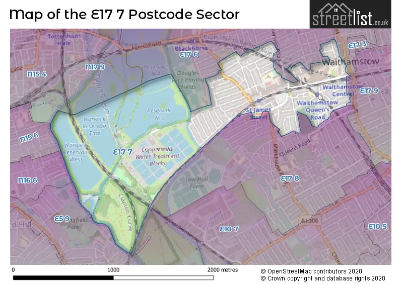
The E17 7 postcode sector is within the county of Greater London.
Did you know? According to the 2021 Census, the E17 7 postcode sector is home to a bustling 12,983 residents!
Given that each sector allows for 400 unique postcode combinations. Letters C, I, K, M, O and V are not allowed in the last two letters of a postcode. With 177 postcodes already in use, this leaves 223 units available.
The E17 7 postal code covers the settlement of WALTHAMSTOW .
The E17 7 Postcode shares a border with N17 9 (TOTTENHAM ), E17 3 (WALTHAMSTOW ), E17 4 (WALTHAMSTOW ), E17 6 (WALTHAMSTOW ), N15 4 (TOTTENHAM ), N15 6 (TOTTENHAM ), N16 6 (HACKNEY ), E5 9 (HACKNEY ), E17 8 (WALTHAMSTOW ) and E17 9 (WALTHAMSTOW ).
The sector is within the post town of LONDON.
E17 7 is a postcode sector within the E17 postcode district which is within the E East London postcode area.
The Royal Mail delivery office for the E17 7 postal sector is the Walthamstow Sdelivery Office.
The area of the E17 7 postcode sector is 0.93 square miles which is 2.41 square kilometres or 596.29 square acres.
Waterways within the E17 7 postcode sector include the River Lea Navigation, Coppermill Stream.

Map of the E17 7 Postcode Sector
Explore the E17 7 postcode sector by using our free interactive map.
| E | 1 | 7 | - | 7 | X | X |
| E | 1 | 7 | Space | 7 | Letter | Letter |
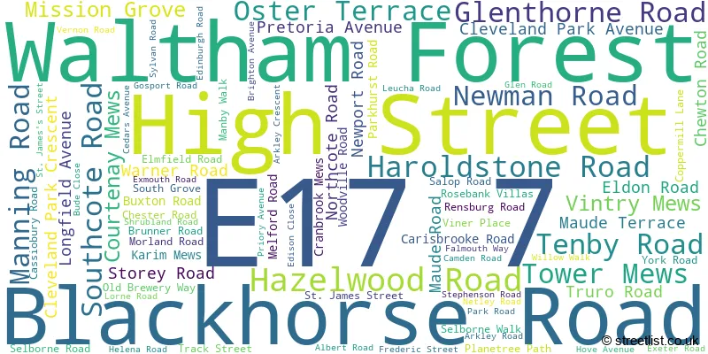
Official List of Streets
Waltham Forest (80 Streets)
Unofficial Streets or Alternative Spellings
Waltham Forest
BEATRICE ROAD CONNAUGHT ROAD CORNWALLIS ROAD COURTENAY ROAD EDWARD ROAD ESSEX ROAD GILLARDS MEWS GRANGE ROAD LEOPOLD ROAD MARKHOUSE ROAD PALACE MEWS PALMERSTON ROAD RINGWOOD ROAD STATION ROAD WESTBURY ROAD BIRCH PATH BRUNNER PATH CHERRY WALK COPPERMILL BRIDGE COURTENAY PLACE EAST CHAPEL PATH FISHERMANS WAY GILLARDS WAY GLEN MEWS HAWTHORN PATH HORSESHOE BRIDGE RAY DUDLEY WAY REMEMBRANCE WALK (EAST) SELBORNE AVENUE ST JAMES PATH ST JAMESS MEWS STATION APPROACH THE HOLLY WALK VERNON MEWS WATERSIDEWeather Forecast for E17 7
Press Button to Show Forecast for Walthamstow
| Time Period | Icon | Description | Temperature | Rain Probability | Wind |
|---|---|---|---|---|---|
| 21:00 to 00:00 | Cloudy | 9.0°C (feels like 6.0°C) | 8.00% | E 9 mph |
Press Button to Show Forecast for Walthamstow
| Time Period | Icon | Description | Temperature | Rain Probability | Wind |
|---|---|---|---|---|---|
| 00:00 to 03:00 | Overcast | 8.0°C (feels like 5.0°C) | 17.00% | ENE 9 mph | |
| 03:00 to 06:00 | Heavy rain | 7.0°C (feels like 4.0°C) | 79.00% | NE 9 mph | |
| 06:00 to 09:00 | Light rain | 6.0°C (feels like 4.0°C) | 53.00% | NE 9 mph | |
| 09:00 to 12:00 | Overcast | 8.0°C (feels like 5.0°C) | 15.00% | NE 9 mph | |
| 12:00 to 15:00 | Cloudy | 11.0°C (feels like 9.0°C) | 13.00% | NE 7 mph | |
| 15:00 to 18:00 | Cloudy | 12.0°C (feels like 11.0°C) | 12.00% | ENE 7 mph | |
| 18:00 to 21:00 | Light rain | 12.0°C (feels like 10.0°C) | 56.00% | NE 9 mph | |
| 21:00 to 00:00 | Light rain | 10.0°C (feels like 8.0°C) | 67.00% | NE 9 mph |
Press Button to Show Forecast for Walthamstow
| Time Period | Icon | Description | Temperature | Rain Probability | Wind |
|---|---|---|---|---|---|
| 00:00 to 03:00 | Heavy rain | 9.0°C (feels like 6.0°C) | 89.00% | NNE 11 mph | |
| 03:00 to 06:00 | Heavy rain | 9.0°C (feels like 6.0°C) | 89.00% | NNE 9 mph | |
| 06:00 to 09:00 | Heavy rain | 9.0°C (feels like 7.0°C) | 87.00% | N 7 mph | |
| 09:00 to 12:00 | Light rain | 9.0°C (feels like 7.0°C) | 58.00% | WNW 9 mph | |
| 12:00 to 15:00 | Light rain | 10.0°C (feels like 7.0°C) | 54.00% | W 11 mph | |
| 15:00 to 18:00 | Overcast | 11.0°C (feels like 9.0°C) | 20.00% | W 11 mph | |
| 18:00 to 21:00 | Cloudy | 11.0°C (feels like 9.0°C) | 10.00% | W 9 mph | |
| 21:00 to 00:00 | Partly cloudy (night) | 9.0°C (feels like 8.0°C) | 5.00% | SW 7 mph |
Press Button to Show Forecast for Walthamstow
| Time Period | Icon | Description | Temperature | Rain Probability | Wind |
|---|---|---|---|---|---|
| 00:00 to 03:00 | Clear night | 8.0°C (feels like 7.0°C) | 2.00% | SW 4 mph | |
| 03:00 to 06:00 | Clear night | 7.0°C (feels like 5.0°C) | 1.00% | SSW 4 mph | |
| 06:00 to 09:00 | Sunny day | 7.0°C (feels like 6.0°C) | 1.00% | S 4 mph | |
| 09:00 to 12:00 | Sunny day | 12.0°C (feels like 10.0°C) | 1.00% | S 9 mph | |
| 12:00 to 15:00 | Cloudy | 14.0°C (feels like 12.0°C) | 8.00% | S 11 mph | |
| 15:00 to 18:00 | Partly cloudy (day) | 15.0°C (feels like 13.0°C) | 2.00% | S 11 mph | |
| 18:00 to 21:00 | Sunny day | 14.0°C (feels like 12.0°C) | 4.00% | S 9 mph | |
| 21:00 to 00:00 | Clear night | 11.0°C (feels like 10.0°C) | 1.00% | SSE 7 mph |
Press Button to Show Forecast for Walthamstow
| Time Period | Icon | Description | Temperature | Rain Probability | Wind |
|---|---|---|---|---|---|
| 00:00 to 03:00 | Clear night | 10.0°C (feels like 8.0°C) | 1.00% | SE 7 mph | |
| 03:00 to 06:00 | Clear night | 9.0°C (feels like 7.0°C) | 2.00% | ESE 7 mph | |
| 06:00 to 09:00 | Cloudy | 9.0°C (feels like 8.0°C) | 8.00% | ESE 7 mph | |
| 09:00 to 12:00 | Cloudy | 13.0°C (feels like 12.0°C) | 8.00% | ESE 7 mph | |
| 12:00 to 15:00 | Cloudy | 16.0°C (feels like 14.0°C) | 10.00% | SE 9 mph | |
| 15:00 to 18:00 | Cloudy | 17.0°C (feels like 15.0°C) | 12.00% | SE 9 mph | |
| 18:00 to 21:00 | Cloudy | 16.0°C (feels like 14.0°C) | 12.00% | SE 9 mph | |
| 21:00 to 00:00 | Cloudy | 13.0°C (feels like 12.0°C) | 16.00% | ESE 7 mph |
Schools and Places of Education Within the E17 7 Postcode Sector
Mission Grove Primary School
Community school
Buxton Road, London, , E17 7EJ
Head: Miss Katie Jennings
Ofsted Rating: Good
Inspection: 2023-07-12 (289 days ago)
Website: Visit Mission Grove Primary School Website
Phone: 02085203487
Number of Pupils: 831
St Patrick's Catholic Primary School
Voluntary aided school
Longfield Avenue, London, , E17 7DP
Head: Mr Ruslan Protsiv
Ofsted Rating: Good
Inspection: 2023-06-15 (316 days ago)
Website: Visit St Patrick's Catholic Primary School Website
Phone: 02085094321
Number of Pupils: 428
House Prices in the E17 7 Postcode Sector
| Type of Property | 2018 Average | 2018 Sales | 2017 Average | 2017 Sales | 2016 Average | 2016 Sales | 2015 Average | 2015 Sales |
|---|---|---|---|---|---|---|---|---|
| Detached | £0 | 0 | £491,000 | 1 | £0 | 0 | £0 | 0 |
| Semi-Detached | £500,000 | 1 | £670,000 | 3 | £781,667 | 3 | £395,000 | 1 |
| Terraced | £606,943 | 61 | £591,793 | 52 | £571,999 | 54 | £512,332 | 59 |
| Flats | £386,508 | 83 | £383,969 | 100 | £354,249 | 97 | £338,451 | 129 |
Important Postcodes E17 7 in the Postcode Sector
E17 7BX is the postcode for Metropolitan Police, Police Station, 191-193 High Street
E17 7DP is the postcode for St. Patricks Catholic Primary School, 1 Longfield Avenue
E17 7EJ is the postcode for Mission Grove Primary School, Buxton Road, PRIMARY SCHOOL, Mission Grove Primary School & Childrens Centre, Buxton Road, Mission Grove Childrens Centre, Buxton Road, and CHILDREN'S CENTRE, Mission Grove Primary School & Childrens Centre, Buxton Road
E17 7JN is the postcode for Walthamstow Library, 206 High Street, and London Borough of Waltham Forest, Central Library, High Street
E17 7JR is the postcode for Units 9 & 10, 45 Selborne Walk
E17 7NH is the postcode for St. James Health Centre, 47 St. James's Street
E17 7QB is the postcode for Mission Grove Primary School (Site 2), 108 Edinburgh Road, Mission Grove Primary School, 108 Edinburgh Road, and Edinburgh Primary School, Edinburgh Road
| The E17 7 Sector is within these Local Authorities |
|
|---|---|
| The E17 7 Sector is within these Counties |
|
| The E17 7 Sector is within these Water Company Areas |
|