
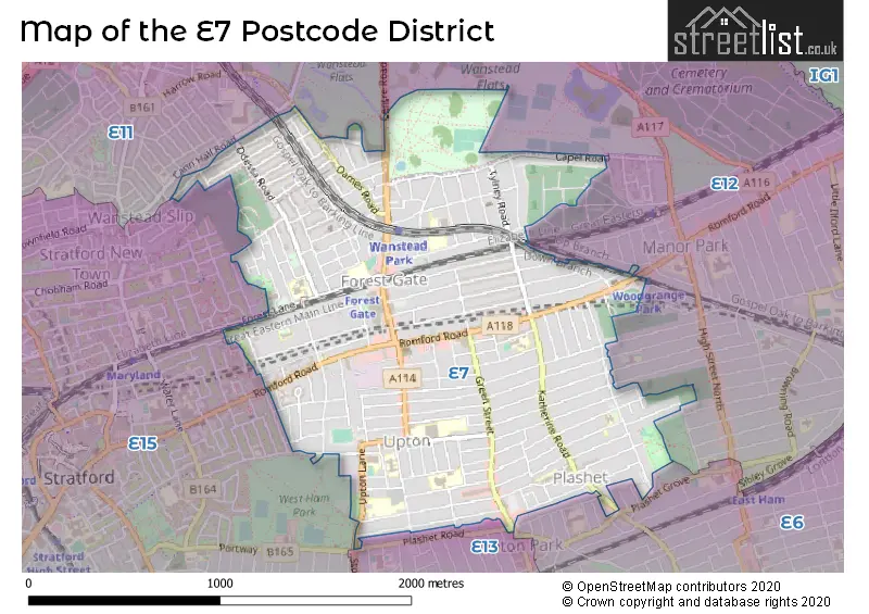
Map of the Postcode District
Explore the postcode district by using our interactive map.
Circles represent recorded crime; the larger the circle, the higher the crime rates.
Your support helps keep this site running!
If you enjoy using this website, consider buying me a coffee to help cover hosting costs.
The postcode district located in the E London - E postal area , E7 has a population of 53,871 residents according to the 2021 England and Wales Census.
The area of the district is 1.46 square miles (3.78 square kilometers or 933.45 acres).
Where is the E7 District?
To give you an idea where the district is located we have created the following table showing nearby towns.
Nearest Towns to E7
| Town | Distance (miles) | Direction |
|---|---|---|
| Chigwell | 5.37 | NNE |
| City of London | 5.70 | WSW |
| City of Westminster | 7.42 | WSW |
| Loughton | 7.67 | NNE |
| Waltham Abbey | 9.61 | N |
| Waltham Cross | 9.92 | NNW |
| Epping | 11.00 | NNE |
| Cheshunt | 11.15 | NNW |
| Dartford | 11.34 | SE |
| Swanley | 12.09 | SSE |
| Swanscombe | 12.82 | ESE |
| Brentwood | 12.97 | ENE |
| Grays | 13.67 | ESE |
| Potters Bar | 13.98 | NW |
| Chipping Ongar | 14.29 | NE |
| Hoddesdon | 14.68 | N |
| Borehamwood | 14.99 | WNW |
| Harlow | 15.56 | N |
| Northfleet | 15.62 | ESE |
| Tilbury | 15.62 | ESE |
The post town for this district is LONDON.
Postcode Information for District E7 (Total Geographical Postcodes: 518)
| Location | Post Town | Sector | Number of Postcodes |
|---|---|---|---|
| Newham | LONDON | E7 9 | 168 |
| Newham | LONDON | E7 8 | 161 |
| Newham | LONDON | E7 0 | 151 |
| Waltham Forest | LONDON | E7 9 | 23 |
| Waltham Forest | LONDON | E7 0 | 14 |
| Redbridge | LONDON | E7 0 | 1 |
Retail and Shopping in E7
Street
Town
Locality
Number of Shops
Central Postcode
View on Google Maps
GREEN STREET
LONDON
280
E7 8LJ
View on Google Maps
KATHERINE ROAD
LONDON
103
E7 8NW
View on Google Maps
WOODGRANGE ROAD
LONDON
97
E7 0EL
View on Google Maps
UPTON LANE
LONDON
95
E7 9PA
View on Google Maps
ROMFORD ROAD
LONDON
89
E7 8BS
View on Google Maps
SEBERT ROAD
LONDON
8
E7 0NQ
View on Google Maps
FOREST LANE
LONDON
7
E7 9BB
View on Google Maps
ST GEORGES ROAD
LONDON
7
E7 8HY
View on Google Maps
WOODFORD ROAD
LONDON
7
E7 0HA
View on Google Maps
SHREWSBURY ROAD
LONDON
6
E7 8QJ
View on Google Maps
| Street | Town | Locality | Number of Shops | Central Postcode | View on Google Maps |
|---|---|---|---|---|---|
| GREEN STREET | LONDON | 280 | E7 8LJ | View on Google Maps | |
| KATHERINE ROAD | LONDON | 103 | E7 8NW | View on Google Maps | |
| WOODGRANGE ROAD | LONDON | 97 | E7 0EL | View on Google Maps | |
| UPTON LANE | LONDON | 95 | E7 9PA | View on Google Maps | |
| ROMFORD ROAD | LONDON | 89 | E7 8BS | View on Google Maps | |
| SEBERT ROAD | LONDON | 8 | E7 0NQ | View on Google Maps | |
| FOREST LANE | LONDON | 7 | E7 9BB | View on Google Maps | |
| ST GEORGES ROAD | LONDON | 7 | E7 8HY | View on Google Maps | |
| WOODFORD ROAD | LONDON | 7 | E7 0HA | View on Google Maps | |
| SHREWSBURY ROAD | LONDON | 6 | E7 8QJ | View on Google Maps |
In the E7 postcode district, the primary settlement is Newham, located in Greater London. Other significant settlements in this district include Redbridge and Waltham Forest. The county is Greater London, and the most significant post town is London.
When it comes to local government, postal geography often disregards political borders. However, this district intersects the following councils: the district mostly encompasses the Newham London Boro (499 postal codes), and finally, the Waltham Forest London Boro area (37 postal codes).
The E7 postal code covers the settlement of FOREST GATE.
The E7 Postcode shares a border with E11 (LEYTONSTONE, WANSTEAD), E12 (MANOR PARK), E13 (PLAISTOW, UPTON PARK), E6 (EAST HAM, BECKTON) and E15 (STRATFORD).


Schools in the Sector
Godwin Junior School
Phase: Primary
Address: Cranmer Road , Forest Gate , London
Postcode: E7 0JW
Headteacher: Ms Sine Brown (Headteacher)
Ofsted Rating: Good
Woodgrange Infant School
Phase: Primary
Address: Sebert Road , London
Postcode: E7 0NJ
Headteacher: Mrs S Soyler (Headteacher)
Ofsted Rating: Good
Kay Rowe Nursery School
Phase: Nursery
Address: Forest Gate , Forest Gate , Osborne Road , London
Postcode: E7 0PH
Headteacher: Ms Sarah Porter (Headteacher)
Ofsted Rating: Outstanding
Zakariya Primary School
Phase: Not applicable
Address: 447-451 Romford Road , Forest Gate , London
Postcode: E7 8AB
Headteacher: Mr Sufyan Rashid (Management)
Ofsted Rating: Inadequate
Sandringham Primary School
Phase: Primary
Address: Sandringham Road , London
Postcode: E7 8ED
Headteacher: Mr R D Cleary (Headteacher)
Ofsted Rating: Outstanding
St Angela's Ursuline School
Phase: Secondary
Address: St George's Road , Forest Gate , London
Postcode: E7 8HU
Headteacher: Mr Mark Johnson (Headteacher)
Ofsted Rating: Outstanding
Elmhurst Primary School
Phase: Primary
Address: Upton Park Road , Forest Gate , London
Postcode: E7 8JY
Headteacher: Mr S Ahmed (Headteacher)
Ofsted Rating: Outstanding
Elmhurst Primary School
Phase: Primary
Address: Upton Park Road , Forest Gate , London
Postcode: E7 8JY
Headteacher: Ms Sukwinder Samra (Headteacher)
Ofsted Rating: Outstanding
William Davies Primary School
Phase: Primary
Address: Stafford Road , London
Postcode: E7 8NL
Headteacher: Ms Sally Norris (Headteacher)
Ofsted Rating: Good
Madaniyah Foundation
Phase: Not applicable
Address: 80 - 82 Stafford Rd , Forest Gate , London
Postcode: E7 8NN
Headteacher: Mr Hanif Mohamed (Headteacher)
Ofsted Rating: Good
Shaftesbury Primary School
Phase: Primary
Address: Shaftesbury Road , Forest Gate , London
Postcode: E7 8PF
Headteacher: Mr Geoff Hadlow (Headteacher)
Ofsted Rating: Outstanding
Shaftesbury Primary School
Phase: Primary
Address: Shaftesbury Road , Forest Gate , London
Postcode: E7 8PF
Headteacher: Mr Geoff Hadlow (Headteacher)
Ofsted Rating: Outstanding
Earlham Primary School
Phase: Primary
Address: Earlham Grove , Forest Gate , London
Postcode: E7 9AW
Headteacher: Ms Laura Hewer (Headteacher)
Ofsted Rating: Good
Earlham Primary School
Phase: Primary
Address: Earlham Grove , Forest Gate , London
Postcode: E7 9AW
Headteacher: Co Headteacher Ms Natalie Robinson, Mr Jacob Oudegeest (Headteacher)
Ofsted Rating: Outstanding
Forest Gate Community School
Phase: Secondary
Address: Forest Lane , London
Postcode: E7 9BB
Headteacher: Mr Simon Elliott (Headteacher)
Ofsted Rating: Outstanding
Forest Gate Community School
Phase: Secondary
Address: Forest Lane , London
Postcode: E7 9BB
Headteacher: Miss Thahmina Begum (Headteacher)
Ofsted Rating: Outstanding
Odessa Infant School
Phase: Primary
Address: Wellington Road , London
Postcode: E7 9BY
Headteacher: Mrs Clare Barber (Headteacher)
Ofsted Rating: Good
St James' CofE Junior School
Phase: Primary
Address: Tower Hamlets Road , Forest Gate , London
Postcode: E7 9DA
Headteacher: Mrs Rose Boland - Bourne (Headteacher)
Ofsted Rating: Good
Quwwat Ul Islam Girls' School
Phase: Not applicable
Address: 16 Chaucer Road , Forest Gate , London
Postcode: E7 9NB
Headteacher: Mrs Shazia Member ()
Ofsted Rating: Requires improvement
St Antony's Catholic Primary School
Phase: Primary
Address: Upton Avenue , Forest Gate , London
Postcode: E7 9PN
Headteacher: Mrs Angela Moore (Headteacher)
Ofsted Rating: Good
St Antony's Catholic Primary School
Phase: Primary
Address: Upton Avenue , Forest Gate , London
Postcode: E7 9PN
Headteacher: Mrs Angela Moore (Headteacher)
Ofsted Rating: Good
Stratford School Academy
Phase: Secondary
Address: Upton Lane , Forest Gate , London
Postcode: E7 9PR
Headteacher: Mr Craig Hewitt (Headteacher)
Ofsted Rating: Good
St Bonaventure's RC School
Phase: Secondary
Address: Boleyn Road , Forest Gate , London
Postcode: E7 9QD
Headteacher: Mr Christopher McCormack (Headteacher)
Ofsted Rating: Outstanding
Stations in the Sector
Woodgrange Park
CRS Code: WGR
Operator: LO
Line: Great Eastern Main Line|Gospel Oak to Barking line
Company: London Overground
Wanstead Park
CRS Code: WNP
Operator: LO
Line: Great Eastern Main Line|Gospel Oak to Barking line
Company: London Overground
Forest Gate
CRS Code: FOG
Operator: XR
Line: Great Eastern Main Line|Gospel Oak to Barking line
Company: TfL Rail
Accessable Motorway Junctions
M11 J5
Average Driving Time from within the district: 12.27
Average Driving Distance: 8.40
Number of Postcodes that can access the Motorway Junction: 531
M11 J6
Average Driving Time from within the district: 14.87
Average Driving Distance: 11.81
Number of Postcodes that can access the Motorway Junction: 16
M25 J27
Average Driving Time from within the district: 15.20
Average Driving Distance: 11.44
Number of Postcodes that can access the Motorway Junction: 526
M25 J30
Average Driving Time from within the district: 17.49
Average Driving Distance: 12.25
Number of Postcodes that can access the Motorway Junction: 63
M25 J26
Average Driving Time from within the district: 19.33
Average Driving Distance: 15.72
Number of Postcodes that can access the Motorway Junction: 531
M25 J25
Average Driving Time from within the district: 22.81
Average Driving Distance: 19.32
Number of Postcodes that can access the Motorway Junction: 452
Weather Forecast for West Ham United F.C.
| Time Period | Icon | Description | Temperature | Rain Probability | Wind |
|---|---|---|---|---|---|
| 12:00 to 15:00 | Partly cloudy (day) | 15.0°C (feels like 13.0°C) | 40.00% | WSW 11 mph | |
| 15:00 to 18:00 | Cloudy | 16.0°C (feels like 15.0°C) | 8.00% | SW 7 mph | |
| 18:00 to 21:00 | Clear night | 14.0°C (feels like 14.0°C) | 35.00% | SW 4 mph | |
| 21:00 to 00:00 | Clear night | 13.0°C (feels like 12.0°C) | 0.00% | SW 4 mph |
| Time Period | Icon | Description | Temperature | Rain Probability | Wind |
|---|---|---|---|---|---|
| 00:00 to 03:00 | Partly cloudy (night) | 11.0°C (feels like 11.0°C) | 2.00% | SW 4 mph | |
| 03:00 to 06:00 | Partly cloudy (night) | 10.0°C (feels like 10.0°C) | 4.00% | SW 2 mph | |
| 06:00 to 09:00 | Fog | 10.0°C (feels like 10.0°C) | 13.00% | S 2 mph | |
| 09:00 to 12:00 | Fog | 12.0°C (feels like 11.0°C) | 12.00% | SSE 4 mph | |
| 12:00 to 15:00 | Partly cloudy (day) | 16.0°C (feels like 15.0°C) | 10.00% | S 7 mph | |
| 15:00 to 18:00 | Cloudy | 16.0°C (feels like 15.0°C) | 14.00% | S 7 mph | |
| 18:00 to 21:00 | Clear night | 13.0°C (feels like 12.0°C) | 0.00% | S 4 mph | |
| 21:00 to 00:00 | Clear night | 11.0°C (feels like 11.0°C) | 0.00% | SE 4 mph |
| Time Period | Icon | Description | Temperature | Rain Probability | Wind |
|---|---|---|---|---|---|
| 00:00 to 03:00 | Clear night | 11.0°C (feels like 10.0°C) | 0.00% | SE 7 mph | |
| 03:00 to 06:00 | Clear night | 11.0°C (feels like 9.0°C) | 1.00% | SE 7 mph | |
| 06:00 to 09:00 | Clear night | 10.0°C (feels like 9.0°C) | 0.00% | SE 7 mph | |
| 09:00 to 12:00 | Sunny day | 13.0°C (feels like 11.0°C) | 1.00% | SSE 9 mph | |
| 12:00 to 15:00 | Partly cloudy (day) | 16.0°C (feels like 14.0°C) | 1.00% | S 11 mph | |
| 15:00 to 18:00 | Sunny day | 17.0°C (feels like 15.0°C) | 2.00% | S 11 mph | |
| 18:00 to 21:00 | Clear night | 15.0°C (feels like 13.0°C) | 2.00% | SSE 9 mph | |
| 21:00 to 00:00 | Clear night | 15.0°C (feels like 13.0°C) | 6.00% | SSE 11 mph |
| Time Period | Icon | Description | Temperature | Rain Probability | Wind |
|---|---|---|---|---|---|
| 00:00 to 03:00 | Clear night | 15.0°C (feels like 13.0°C) | 17.00% | S 11 mph | |
| 03:00 to 06:00 | Light rain | 14.0°C (feels like 12.0°C) | 46.00% | SSW 11 mph | |
| 06:00 to 09:00 | Cloudy | 13.0°C (feels like 11.0°C) | 13.00% | SSW 7 mph | |
| 09:00 to 12:00 | Partly cloudy (day) | 13.0°C (feels like 11.0°C) | 7.00% | SSW 9 mph | |
| 12:00 to 15:00 | Partly cloudy (day) | 14.0°C (feels like 12.0°C) | 10.00% | SW 11 mph | |
| 15:00 to 18:00 | Partly cloudy (day) | 14.0°C (feels like 12.0°C) | 9.00% | SW 11 mph | |
| 18:00 to 21:00 | Clear night | 12.0°C (feels like 10.0°C) | 6.00% | SW 11 mph | |
| 21:00 to 00:00 | Clear night | 10.0°C (feels like 8.0°C) | 1.00% | SW 9 mph |
| Time Period | Icon | Description | Temperature | Rain Probability | Wind |
|---|---|---|---|---|---|
| 00:00 to 03:00 | Clear night | 9.0°C (feels like 7.0°C) | 1.00% | SW 9 mph | |
| 03:00 to 06:00 | Clear night | 9.0°C (feels like 7.0°C) | 1.00% | SW 9 mph | |
| 06:00 to 09:00 | Clear night | 9.0°C (feels like 7.0°C) | 3.00% | SW 9 mph | |
| 09:00 to 12:00 | Sunny day | 11.0°C (feels like 8.0°C) | 6.00% | SW 11 mph | |
| 12:00 to 15:00 | Partly cloudy (day) | 13.0°C (feels like 11.0°C) | 8.00% | SW 13 mph | |
| 15:00 to 18:00 | Cloudy | 14.0°C (feels like 11.0°C) | 13.00% | SW 11 mph | |
| 18:00 to 21:00 | Clear night | 12.0°C (feels like 10.0°C) | 10.00% | SW 11 mph | |
| 21:00 to 00:00 | Clear night | 12.0°C (feels like 10.0°C) | 6.00% | SW 11 mph |
| Postal Sector | Delivery Office |
|---|---|
| E7 0 | Forest Gate Sdelivery Office |
| E7 8 | Forest Gate Sdelivery Office |
| E7 9 | Forest Gate Sdelivery Office |
| E | 7 | - | X | X | X |
| E | 7 | Space | Numeric | Letter | Letter |
Street List for the E7 District
Current Monthly Rental Prices
| # Bedrooms | Min Price | Max Price | Avg Price |
|---|---|---|---|
| 1 | £700 | £1,800 | £1,375 |
| 2 | £1,550 | £2,300 | £1,933 |
| 3 | £2,095 | £2,400 | £2,279 |
| 4 | £2,600 | £2,800 | £2,700 |
| 5 | £5,500 | £5,500 | £5,500 |
| 7 | £3,950 | £3,950 | £3,950 |
Current House Prices
| # Bedrooms | Min Price | Max Price | Avg Price |
|---|---|---|---|
| £190,000 | £190,000 | £190,000 | |
| 1 | £102,500 | £450,000 | £279,398 |
| 2 | £131,250 | £575,000 | £340,079 |
| 3 | £235,000 | £750,000 | £528,082 |
| 4 | £595,000 | £1,100,000 | £814,545 |
| 5 | £600,000 | £895,000 | £759,000 |
| 6 | £800,000 | £800,000 | £800,000 |
| 7 | £1,600,000 | £1,600,000 | £1,600,000 |
| 8 | £1,150,000 | £1,150,000 | £1,150,000 |
Estate Agents
| Logo | Name | Brand Name | Address | Contact Number |
|---|---|---|---|---|
 | Stratford | Foxtons | 9 The Grove, London, E15 1EL | 020 3909 4203 |
 | Wanstead | The Stow Brothers | 117a High Street Wanstead, London, E11 2RL | 020 3397 2222 |
 | London | Wilkinson Estate Agents | 78 Woodgrange Road, London, E7 0EN | 020 3909 0359 |
 | Stratford | Bairstow Eves | 142 The Grove, Stratford, London, E15 1NS | 020 3873 5835 |
 | East Ham | Douglas Allen | 160 High Street North, East Ham, London, E6 2HT | 020 3871 1986 |
Yearly House Price Averages for the District
| Type of Property | 2018 Average | 2018 Sales | 2017 Average | 2017 Sales | 2016 Average | 2016 Sales | 2015 Average | 2015 Sales |
|---|---|---|---|---|---|---|---|---|
| Detached | £825,000 | 1 | £830,600 | 5 | £855,333 | 3 | £651,667 | 3 |
| Semi-Detached | £594,670 | 18 | £644,908 | 16 | £598,100 | 15 | £501,692 | 13 |
| Terraced | £499,637 | 181 | £482,281 | 177 | £458,773 | 219 | £390,256 | 280 |
| Flats | £289,198 | 79 | £289,521 | 97 | £282,965 | 133 | £227,767 | 156 |