The GL54 postcode district is a postal district located in the GL Gloucester postcode area with a population of 24,779 residents according to the 2021 England and Wales Census.
The area of the GL54 postcode district is 182.32 square miles which is 472.20 square kilometres or 116,682.43 acres.
Currently, the GL54 district has about 1037 postcode units spread across 5 geographic postcode sectors.
Given that each sector allows for 400 unique postcode combinations, the district has a capacity of 2,000 postcodes. With 1037 postcodes already in use, this leaves 963 units available.
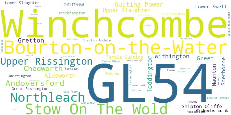
The largest settlement in the GL54 postal code is Winchcombe followed by Bourton-on-the-Water, and Stow On The Wold.
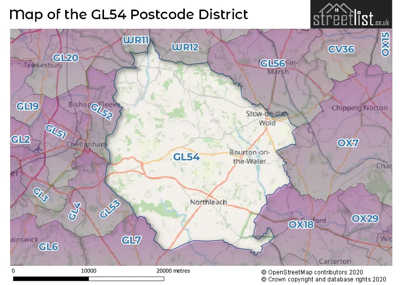
The GL54 Postcode shares a border with GL56 (MORETON-IN-MARSH, Blockley, Longborough), WR11 (EVESHAM, Badsey, Honeybourne), WR12 (BROADWAY, Willersey, Childswickham), OX7 (CHIPPING NORTON, Charlbury, Milton-under-Wychwood), GL7 (CIRENCESTER, South Cerney, FAIRFORD), GL20 (TEWKESBURY, Walton Cardiff, Northway), GL52 (CHELTENHAM, Bishops Cleeve, Prestbury), GL53 (CHELTENHAM, Charlton Kings, Leckhampton) and OX18 (CARTERTON, BAMPTON, BURFORD).
In the GL54 postcode district, the primary settlement is Stow On The Wold, located in the county of Gloucestershire in England. Other significant settlements include Bourton-on-the-Water, Upper Rissington, Northleach, Andoversford, Winchcombe, Gretton, Guiting Power, and Lower Slaughter. The main post town is Cheltenham.
For the district GL54, we have data on 5 postcode sectors. Here's a breakdown: The sector GL54 1, covers Stow On The Wold and Lower Swell in Gloucestershire. The sector GL54 2, covers Bourton-On-The-Water and Upper Rissington in Gloucestershire. The sector GL54 3, covers Northleach and Aldsworth in Gloucestershire. The sector GL54 4, covers Andoversford and Chedworth and Withington and Shipton Oliffe in Gloucestershire. The sector GL54 5, covers Winchcombe in Gloucestershire.

Map of the GL54 Postcode District
Explore the GL54 postcode district by using our free interactive map.
When it comes to local government, postal geography often disregards political borders. However, for a breakdown in the GL54 District: the district mostly encompasses the Cotswold District (798 postcodes), followed by the Tewkesbury District (B) area (256 postcodes), and finally, the Cheltenham District (B) area (5 postcodes).
Recent House Sales in GL54
| Date | Price | Address |
|---|---|---|
| 24/10/2023 | £475,000 | Hunters Way, Andoversford, Cheltenham, GL54 4JW |
| 20/10/2023 | £530,000 | Redwood Close, Gretton, Cheltenham, GL54 5JW |
| 19/10/2023 | £800,000 | Gloucester Street, Winchcombe, Cheltenham, GL54 5NA |
| 17/10/2023 | £320,000 | Bull Lane, Winchcombe, Cheltenham, GL54 5HY |
| 22/09/2023 | £375,000 | Rissington Road, Bourton On The Water, Cheltenham, GL54 2AY |
| 15/09/2023 | £625,000 | Sheep Street, Stow On The Wold, Cheltenham, GL54 1AA |
| 14/09/2023 | £560,000 | Rye Close, Bourton On The Water, Cheltenham, GL54 2EA |
| 08/09/2023 | £265,000 | Folly Field, Bourton On The Water, Cheltenham, GL54 2HH |
| 08/09/2023 | £1,090,000 | Fields Road, Chedworth, Cheltenham, GL54 4NQ |
| 08/09/2023 | £840,000 | Brockhampton, Cheltenham, GL54 5XQ |
Weather Forecast for GL54
Press Button to Show Forecast for Bourton-On-The-Water
| Time Period | Icon | Description | Temperature | Rain Probability | Wind |
|---|---|---|---|---|---|
| 06:00 to 09:00 | Light rain | 5.0°C (feels like 2.0°C) | 56.00% | ENE 9 mph | |
| 09:00 to 12:00 | Light rain | 6.0°C (feels like 2.0°C) | 57.00% | ENE 11 mph | |
| 12:00 to 15:00 | Light rain | 7.0°C (feels like 4.0°C) | 50.00% | ENE 11 mph | |
| 15:00 to 18:00 | Overcast | 8.0°C (feels like 5.0°C) | 14.00% | NE 11 mph | |
| 18:00 to 21:00 | Overcast | 8.0°C (feels like 5.0°C) | 12.00% | NE 11 mph | |
| 21:00 to 00:00 | Cloudy | 6.0°C (feels like 3.0°C) | 20.00% | NNE 11 mph |
Press Button to Show Forecast for Bourton-On-The-Water
| Time Period | Icon | Description | Temperature | Rain Probability | Wind |
|---|---|---|---|---|---|
| 00:00 to 03:00 | Light rain | 6.0°C (feels like 2.0°C) | 55.00% | NNE 13 mph | |
| 03:00 to 06:00 | Heavy rain | 5.0°C (feels like 1.0°C) | 81.00% | N 13 mph | |
| 06:00 to 09:00 | Heavy rain | 5.0°C (feels like 1.0°C) | 84.00% | N 13 mph | |
| 09:00 to 12:00 | Heavy rain | 6.0°C (feels like 3.0°C) | 82.00% | NNW 11 mph | |
| 12:00 to 15:00 | Light rain | 8.0°C (feels like 5.0°C) | 51.00% | NW 11 mph | |
| 15:00 to 18:00 | Cloudy | 10.0°C (feels like 7.0°C) | 15.00% | WNW 9 mph | |
| 18:00 to 21:00 | Cloudy | 9.0°C (feels like 8.0°C) | 7.00% | WSW 7 mph | |
| 21:00 to 00:00 | Clear night | 6.0°C (feels like 4.0°C) | 2.00% | SW 7 mph |
Press Button to Show Forecast for Bourton-On-The-Water
| Time Period | Icon | Description | Temperature | Rain Probability | Wind |
|---|---|---|---|---|---|
| 00:00 to 03:00 | Clear night | 4.0°C (feels like 2.0°C) | 1.00% | SW 7 mph | |
| 03:00 to 06:00 | Clear night | 4.0°C (feels like 1.0°C) | 1.00% | SSW 7 mph | |
| 06:00 to 09:00 | Sunny day | 5.0°C (feels like 2.0°C) | 1.00% | S 7 mph | |
| 09:00 to 12:00 | Partly cloudy (day) | 10.0°C (feels like 8.0°C) | 1.00% | S 13 mph | |
| 12:00 to 15:00 | Cloudy | 12.0°C (feels like 9.0°C) | 7.00% | S 13 mph | |
| 15:00 to 18:00 | Cloudy | 13.0°C (feels like 10.0°C) | 7.00% | S 16 mph | |
| 18:00 to 21:00 | Sunny day | 11.0°C (feels like 9.0°C) | 4.00% | S 11 mph | |
| 21:00 to 00:00 | Clear night | 8.0°C (feels like 5.0°C) | 3.00% | SSE 9 mph |
Press Button to Show Forecast for Bourton-On-The-Water
| Time Period | Icon | Description | Temperature | Rain Probability | Wind |
|---|---|---|---|---|---|
| 00:00 to 03:00 | Clear night | 7.0°C (feels like 4.0°C) | 2.00% | SE 9 mph | |
| 03:00 to 06:00 | Clear night | 6.0°C (feels like 4.0°C) | 2.00% | SE 9 mph | |
| 06:00 to 09:00 | Partly cloudy (day) | 8.0°C (feels like 5.0°C) | 5.00% | SE 9 mph | |
| 09:00 to 12:00 | Sunny day | 12.0°C (feels like 10.0°C) | 7.00% | SE 11 mph | |
| 12:00 to 15:00 | Partly cloudy (day) | 15.0°C (feels like 12.0°C) | 11.00% | SE 13 mph | |
| 15:00 to 18:00 | Cloudy | 15.0°C (feels like 12.0°C) | 12.00% | SE 11 mph | |
| 18:00 to 21:00 | Partly cloudy (day) | 14.0°C (feels like 12.0°C) | 5.00% | SE 9 mph | |
| 21:00 to 00:00 | Partly cloudy (night) | 10.0°C (feels like 8.0°C) | 6.00% | ESE 7 mph |
Where is the GL54 Postcode District?
The postcode district GL54 is located in Cheltenham, a town in Gloucestershire. It is situated near several other towns, such as Moreton-in-Marsh to the North East, Broadway to the North, Burford to the South East, Cirencester to the South West, and Lechlade to the South. Additionally, this district is approximately 79.1 miles away from the center of London.
The district is within the post town of CHELTENHAM.
The sector has postcodes within the nation of England.
The GL54 Postcode District is in the Gloucestershire region of Gloucestershire, Wiltshire and Bath/Bristol area within the South West (England).
| Postcode Sector | Delivery Office |
|---|---|
| GL54 1 | Stow On The Wold Scale Payment Delivery Office |
| GL54 2 | Bourton On The Water Scale Payment Delivery Office |
| GL54 2 | Cheltenham Delivery Office |
| GL54 3 | Bourton On The Water Scale Payment Delivery Office |
| GL54 3 | Cheltenham Delivery Office |
| GL54 3 | Northleach Scale Payment Delivery Office |
| GL54 4 | Cheltenham Delivery Office |
| GL54 4 | Northleach Scale Payment Delivery Office |
| GL54 5 | Cheltenham Delivery Office |
| GL54 5 | Winchcombe Scale Payment Delivery Office |
| G | L | 5 | 4 | - | X | X | X |
| G | L | 5 | 4 | Space | Numeric | Letter | Letter |
Tourist Attractions within the Postcode Area
We found 5 visitor attractions within the GL54 postcode area
| Winchcombe Folk and Police Museum |
|---|
| Museums & Art Galleries |
| Museum and / or Art Gallery |
| View Winchcombe Folk and Police Museum on Google Maps |
| Sudeley Castle Gardens and Exhibitions |
| Historic Properties |
| Historic House / House and Garden / Palace |
| View Sudeley Castle Gardens and Exhibitions on Google Maps |
| Hailes Abbey |
| Historic Properties |
| Historic Monument / Archaeological Site |
| View Hailes Abbey on Google Maps |
| Chedworth Roman Villa (National Trust) |
| Historic Properties |
| Other Historic Property |
| View Chedworth Roman Villa (National Trust) on Google Maps |
| Lodge Park & Sherborne Estate |
| Historic Properties |
| Other Historic Property |
| View Lodge Park & Sherborne Estate on Google Maps |
Current Monthly Rental Prices
| # Bedrooms | Min Price | Max Price | Avg Price |
|---|---|---|---|
| 1 | £1,200 | £2,740 | £2,226 |
| 2 | £975 | £3,410 | £2,229 |
| 3 | £1,100 | £4,500 | £2,585 |
| 4 | £2,100 | £5,500 | £3,700 |
| 5 | £2,250 | £18,000 | £5,800 |
Current House Prices
| # Bedrooms | Min Price | Max Price | Avg Price |
|---|---|---|---|
| £500,000 | £3,000,000 | £1,875,000 | |
| 1 | £80,000 | £345,000 | £224,579 |
| 2 | £185,000 | £625,000 | £386,915 |
| 3 | £230,000 | £4,000,000 | £573,500 |
| 4 | £400,000 | £2,250,000 | £881,115 |
| 5 | £650,000 | £2,650,000 | £1,233,864 |
| 6 | £890,000 | £3,500,000 | £1,987,222 |
| 7 | £1,075,000 | £1,075,000 | £1,075,000 |
| 8 | £1,000,000 | £2,250,000 | £1,625,000 |
| 9 | £7,000,000 | £7,000,000 | £7,000,000 |
| 10 | £4,500,000 | £4,500,000 | £4,500,000 |
Estate Agents who Operate in the GL54 District
| Logo | Name | Brand Name | Address | Contact Number | Total Properties |
|---|---|---|---|---|---|
 | Bourton-On-The-Water | Harrison Hardie | High Street Bourton-On-The-Water GL54 2AN | 01451 604067 | 23 |
 | Bourton On The Water | Tayler & Fletcher | London House, High Street, Bourton-On-The-Water, GL54 2AP | 01451 604030 | 21 |
 | Burford | Jackson-Stops | The Lodge, Woodgrove Farm, Fulbrook, Burford, OX18 4BH | 01993 225864 | 13 |
 | Winchcombe | Adams Estate Agents & Residential Lettings | 20 North Street, Winchcombe, GL54 5LH | 01242 339219 | 12 |
 | Stow-On-The-Wold | Tayler & Fletcher | Tayler & Fletcher, Digbeth Street, Stow On The Wold, GL54 1BN | 01451 604058 | 11 |
- Alderton
- Aldsworth
- Andoversford
- Bourton-on-the-Water
- Broadway
- Brockhampton
- Chedworth
- Cheltenham
- Cleeve Hill
- Cold Aston
- Condicote
- Fossebridge
- Great Rissington
- Greet
- Gretton
- Guiting Power
- Icomb
- Little Barrington
- Little Rissington
- Longborough
- Lower Slaughter
- Lower Swell
- Maugersbury
- Naunton
- New Town
- Northleach
- Prestbury
- Sevenhampton
- Sherborne
- Shipton
- Stow-on-the-Wold
- Temple Guiting
- Toddington
- Turkdean
- Upper Oddington
- Upper Rissington
- Upper Slaughter
- Whittington
- Winchcombe
- Winson
- Withington
- Woodmancote
| Type of Property | 2018 Average | 2018 Sales | 2017 Average | 2017 Sales | 2016 Average | 2016 Sales | 2015 Average | 2015 Sales |
|---|---|---|---|---|---|---|---|---|
| Detached | £601,009 | 212 | £605,893 | 212 | £517,854 | 294 | £487,147 | 286 |
| Semi-Detached | £360,604 | 100 | £344,136 | 151 | £307,976 | 144 | £299,478 | 141 |
| Terraced | £305,118 | 110 | £311,012 | 147 | £297,314 | 127 | £311,633 | 145 |
| Flats | £278,578 | 71 | £241,974 | 78 | £206,072 | 34 | £191,857 | 34 |