The GL7 postcode district is a postal district located in the GL Gloucester postcode area with a population of 45,503 residents according to the 2021 England and Wales Census.
The area of the GL7 postcode district is 161.30 square miles which is 417.77 square kilometres or 103,233.82 acres.
Currently, the GL7 district has about 1657 postcode units spread across 7 geographic postcode sectors.
Given that each sector allows for 400 unique postcode combinations, the district has a capacity of 2,800 postcodes. With 1657 postcodes already in use, this leaves 1143 units available.
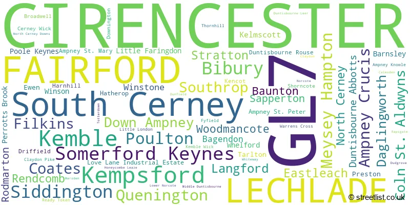
The largest settlement in the GL7 postal code is CIRENCESTER followed by South Cerney, and FAIRFORD.
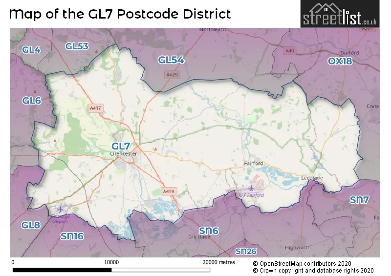
The GL7 Postcode shares a border with GL53 (CHELTENHAM, Charlton Kings, Leckhampton), GL6 (Nailsworth, Minchinhampton, Chalford), GL8 (TETBURY, Avening, Westonbirt), OX18 (CARTERTON, BAMPTON, BURFORD), SN6 (Highworth, Cricklade, Shrivenham), SN7 (FARINGDON, Stanford In The Vale, Uffington), GL54 (Winchcombe, Bourton-on-the-Water, Stow On The Wold) and SN16 (MALMESBURY, Minety, Sherston).
The GL7 postcode district in Gloucestershire, England, primarily consists of the settlement of Cirencester. Other significant settlements within this district include Lechlade, Fairford, and South Cerney. The post town for this district is Cirencester, which has the highest number of postcodes.
For the district GL7, we have data on 8 postcode sectors. Here's a breakdown: The sector GL7 1, covers Cirencester in Gloucestershire. The sector GL7 2, covers Cirencester in Gloucestershire. The sector GL7 3, covers Lechlade in Gloucestershire. The sector GL7 4, covers Fairford and Kempsford in Gloucestershire. The sector GL7 5, covers South Cerney in Gloucestershire. The sector GL7 6, covers Somerford Keynes and Kemble and Siddington and Coates in Gloucestershire. The sector GL7 7, covers Daglingworth and Baunton and North Cerney and Rendcomb and Woodmancote in Gloucestershire. The sector GL7 9 is non-geographic. It's often designated for PO Boxes, large organisations, or special services.

Map of the GL7 Postcode District
Explore the GL7 postcode district by using our free interactive map.
When it comes to local government, postal geography often disregards political borders. However, for a breakdown in the GL7 District: the district mostly encompasses the Cotswold District (1602 postcodes), followed by the West Oxfordshire District area (60 postcodes), followed by the Wiltshire area (13 postcodes), and finally, the Stroud District area (3 postcodes).
Recent House Sales in GL7
| Date | Price | Address |
|---|---|---|
| 27/10/2023 | £330,000 | Station Road, South Cerney, Cirencester, GL7 5TH |
| 13/10/2023 | £260,000 | Lakeside, Fairford, GL7 4DN |
| 10/10/2023 | £660,000 | London Road, Poulton, Cirencester, GL7 5JE |
| 03/10/2023 | £775,000 | Lower Mill Estate, Somerford Keynes, Cirencester, GL7 6FN |
| 03/10/2023 | £760,000 | Milking Path Way, Fairford, GL7 4FR |
| 03/10/2023 | £450,000 | Gloucester Road, Cirencester, GL7 2LF |
| 02/10/2023 | £282,500 | Falstaff Close, Cirencester, GL7 1ZG |
| 29/09/2023 | £425,000 | Kingsmead, Lechlade, GL7 3BN |
| 29/09/2023 | £680,000 | West Way, Lechlade, GL7 3BT |
| 25/09/2023 | £302,000 | Queens Field, Fairford, GL7 4JP |
Weather Forecast for GL7
Press Button to Show Forecast for Ampney St. Peter
| Time Period | Icon | Description | Temperature | Rain Probability | Wind |
|---|---|---|---|---|---|
| 21:00 to 00:00 | Cloudy | 8.0°C (feels like 5.0°C) | 11.00% | ENE 9 mph |
Press Button to Show Forecast for Ampney St. Peter
| Time Period | Icon | Description | Temperature | Rain Probability | Wind |
|---|---|---|---|---|---|
| 00:00 to 03:00 | Light rain | 7.0°C (feels like 4.0°C) | 52.00% | ENE 9 mph | |
| 03:00 to 06:00 | Light rain | 5.0°C (feels like 2.0°C) | 58.00% | ENE 9 mph | |
| 06:00 to 09:00 | Light rain | 5.0°C (feels like 2.0°C) | 59.00% | NE 9 mph | |
| 09:00 to 12:00 | Overcast | 6.0°C (feels like 2.0°C) | 51.00% | NE 13 mph | |
| 12:00 to 15:00 | Overcast | 8.0°C (feels like 4.0°C) | 14.00% | ENE 11 mph | |
| 15:00 to 18:00 | Overcast | 9.0°C (feels like 6.0°C) | 14.00% | NE 11 mph | |
| 18:00 to 21:00 | Cloudy | 8.0°C (feels like 6.0°C) | 8.00% | NE 11 mph | |
| 21:00 to 00:00 | Overcast | 7.0°C (feels like 4.0°C) | 44.00% | NNE 11 mph |
Press Button to Show Forecast for Ampney St. Peter
| Time Period | Icon | Description | Temperature | Rain Probability | Wind |
|---|---|---|---|---|---|
| 00:00 to 03:00 | Light rain | 6.0°C (feels like 3.0°C) | 56.00% | NNE 13 mph | |
| 03:00 to 06:00 | Heavy rain | 6.0°C (feels like 2.0°C) | 81.00% | N 13 mph | |
| 06:00 to 09:00 | Heavy rain | 5.0°C (feels like 2.0°C) | 85.00% | N 13 mph | |
| 09:00 to 12:00 | Heavy rain | 6.0°C (feels like 3.0°C) | 82.00% | NNW 11 mph | |
| 12:00 to 15:00 | Overcast | 9.0°C (feels like 6.0°C) | 22.00% | NW 11 mph | |
| 15:00 to 18:00 | Overcast | 10.0°C (feels like 8.0°C) | 16.00% | W 9 mph | |
| 18:00 to 21:00 | Cloudy | 10.0°C (feels like 8.0°C) | 7.00% | W 7 mph | |
| 21:00 to 00:00 | Clear night | 7.0°C (feels like 4.0°C) | 1.00% | SW 7 mph |
Press Button to Show Forecast for Ampney St. Peter
| Time Period | Icon | Description | Temperature | Rain Probability | Wind |
|---|---|---|---|---|---|
| 00:00 to 03:00 | Clear night | 4.0°C (feels like 2.0°C) | 1.00% | SW 4 mph | |
| 03:00 to 06:00 | Clear night | 4.0°C (feels like 1.0°C) | 1.00% | SSW 7 mph | |
| 06:00 to 09:00 | Sunny day | 5.0°C (feels like 3.0°C) | 1.00% | S 7 mph | |
| 09:00 to 12:00 | Partly cloudy (day) | 11.0°C (feels like 8.0°C) | 2.00% | S 13 mph | |
| 12:00 to 15:00 | Overcast | 12.0°C (feels like 10.0°C) | 11.00% | S 13 mph | |
| 15:00 to 18:00 | Partly cloudy (day) | 13.0°C (feels like 10.0°C) | 3.00% | S 13 mph | |
| 18:00 to 21:00 | Sunny day | 12.0°C (feels like 9.0°C) | 4.00% | S 11 mph | |
| 21:00 to 00:00 | Clear night | 8.0°C (feels like 6.0°C) | 3.00% | SSE 9 mph |
Press Button to Show Forecast for Ampney St. Peter
| Time Period | Icon | Description | Temperature | Rain Probability | Wind |
|---|---|---|---|---|---|
| 00:00 to 03:00 | Clear night | 7.0°C (feels like 5.0°C) | 2.00% | SE 9 mph | |
| 03:00 to 06:00 | Clear night | 7.0°C (feels like 4.0°C) | 2.00% | SE 9 mph | |
| 06:00 to 09:00 | Partly cloudy (day) | 8.0°C (feels like 5.0°C) | 4.00% | ESE 9 mph | |
| 09:00 to 12:00 | Sunny day | 12.0°C (feels like 10.0°C) | 8.00% | SE 11 mph | |
| 12:00 to 15:00 | Partly cloudy (day) | 14.0°C (feels like 12.0°C) | 10.00% | SE 13 mph | |
| 15:00 to 18:00 | Partly cloudy (day) | 15.0°C (feels like 12.0°C) | 10.00% | SE 13 mph | |
| 18:00 to 21:00 | Partly cloudy (day) | 14.0°C (feels like 12.0°C) | 7.00% | SE 9 mph | |
| 21:00 to 00:00 | Partly cloudy (night) | 10.0°C (feels like 9.0°C) | 6.00% | ESE 7 mph |
Where is the GL7 Postcode District?
The GL7 postcode district is located in Cirencester. It is situated near several towns: Lechlade to the east (approximately 3.66 miles away), Swindon to the south (approximately 11.59 miles away), Burford to the northeast (approximately 11.81 miles away), Cheltenham to the northwest (approximately 12.87 miles away), and Malmesbury to the southwest (approximately 13.08 miles away). Additionally, the distance between Cirencester and the center of London is approximately 76.95 miles.
The district covers the post towns of CIRENCESTER, FAIRFORD, LECHLADE.
The sector has postcodes within the nation of England.
The GL7 Postcode District is covers the following regions.
- Gloucestershire - Gloucestershire, Wiltshire and Bath/Bristol area - South West (England)
- Oxfordshire - Berkshire, Buckinghamshire and Oxfordshire - South East (England)
- Wiltshire - Gloucestershire, Wiltshire and Bath/Bristol area - South West (England)
| Postcode Sector | Delivery Office |
|---|---|
| GL7 1 | Cirencester Delivery Office |
| GL7 2 | Cirencester Delivery Office |
| GL7 3 | Cirencester Delivery Office |
| GL7 3 | Lechlade Scale Payment Delivery Office |
| GL7 4 | Cirencester Delivery Office |
| GL7 4 | Fairford Scale Payment Delivery Office |
| GL7 5 | Cirencester Delivery Office |
| GL7 6 | Cirencester Delivery Office |
| GL7 7 | Cirencester Delivery Office |
| G | L | 7 | - | X | X | X |
| G | L | 7 | Space | Numeric | Letter | Letter |
Tourist Attractions within the Postcode Area
We found 4 visitor attractions within the GL7 postcode area
| Corinium Museum |
|---|
| Museums & Art Galleries |
| Museum and / or Art Gallery |
| View Corinium Museum on Google Maps |
| St John the Baptist, Cirencester |
| Places of Worship |
| Place of Worship (still in use) |
| View St John the Baptist, Cirencester on Google Maps |
| The Parish Church of St John the Baptist |
| Places of Worship |
| Place of Worship (still in use) |
| View The Parish Church of St John the Baptist on Google Maps |
| Kelmscott Manor |
| Museums & Art Galleries |
| Museum and / or Art Gallery |
| View Kelmscott Manor on Google Maps |
Current Monthly Rental Prices
| # Bedrooms | Min Price | Max Price | Avg Price |
|---|---|---|---|
| 1 | £630 | £875 | £753 |
| 2 | £850 | £1,950 | £1,239 |
| 3 | £1,200 | £30,333 | £4,171 |
| 4 | £1,525 | £43,333 | £6,155 |
| 5 | £3,500 | £6,500 | £5,000 |
| 6 | £8,750 | £27,300 | £17,017 |
| 7 | £20,000 | £20,000 | £20,000 |
| 8 | £20,833 | £20,833 | £20,833 |
Current House Prices
| # Bedrooms | Min Price | Max Price | Avg Price |
|---|---|---|---|
| £125,000 | £4,000,000 | £1,271,429 | |
| 1 | £60,000 | £375,000 | £224,490 |
| 2 | £36,000 | £650,000 | £293,047 |
| 3 | £20,000 | £1,400,000 | £439,350 |
| 4 | £199,950 | £3,000,000 | £755,108 |
| 5 | £500,000 | £3,950,000 | £1,268,224 |
| 6 | £625,000 | £5,500,000 | £2,074,579 |
| 7 | £2,500,000 | £2,500,000 | £2,500,000 |
| 8 | £6,500,000 | £6,500,000 | £6,500,000 |
| 9 | £1,250,000 | £1,250,000 | £1,250,000 |
| 10 | £2,200,000 | £2,200,000 | £2,200,000 |
| 12 | £3,850,000 | £3,850,000 | £3,850,000 |
Estate Agents who Operate in the GL7 District
| Logo | Name | Brand Name | Address | Contact Number | Total Properties |
|---|---|---|---|---|---|
 | Cirencester | Perry Bishop | 2 Silver Street, Cirencester, GL7 2BL | 01285 704455 | 49 |
 | Cricklade | CBSlade | 105 High Street, Cricklade, SN6 6AA | 01793 540689 | 41 |
 | Cirencester | Cain & Fuller Estate Agents | 53 castle street cirencester GL7 1QD | 01285 704350 | 21 |
 | Cirencester | Moore Allen & Innocent | 33 Castle Street, Cirencester, GL7 1QD | 01285 704358 | 20 |
 | Cirencester | CJ Hole | Unit 1, Woolrich House The Waterloo, Cirencester, GL7 2GA | 01285 704386 | 19 |
- Ablington
- Aldsworth
- Alvescot
- Ampney Crucis
- Arlington
- Baunton
- Bibury
- Bradwell
- Broadwell
- Cerney Wick
- Chedworth
- Chelworth
- Cirencester
- Coates
- Coln St Aldwyns
- Daglingworth
- Down Ampney
- Eastleach Turville
- Edgeworth
- Ewen
- Fairford
- Filkins
- Harnhill
- Hatherop
- Horcott
- Kelmscott
- Kemble
- Kempsford
- Langford
- Lechlade-on-Thames
- Little Faringdon
- Marston Meysey
- Meysey Hampton
- North Cerney
- Perrott's Brook
- Poulton
- Preston
- Quenington
- Rendcomb
- Rodmarton
- Sapperton
- Siddington
- Somerford Keynes
- South Cerney
- Southrop
- Stratton
- Tarlton
- Upper Siddington
- Waterlane
- Whelford
- Winson
- Winstone
- Woodmancote
| Type of Property | 2018 Average | 2018 Sales | 2017 Average | 2017 Sales | 2016 Average | 2016 Sales | 2015 Average | 2015 Sales |
|---|---|---|---|---|---|---|---|---|
| Detached | £580,319 | 274 | £548,716 | 358 | £522,036 | 364 | £562,696 | 310 |
| Semi-Detached | £351,385 | 199 | £329,444 | 209 | £319,134 | 208 | £303,691 | 154 |
| Terraced | £281,532 | 172 | £269,962 | 195 | £262,890 | 264 | £255,733 | 222 |
| Flats | £208,406 | 104 | £231,496 | 134 | £178,669 | 96 | £159,659 | 119 |