The HP15 7 postcode sector is within the county of Buckinghamshire.
Did you know? According to the 2021 Census, the HP15 7 postcode sector is home to a bustling 9,130 residents!
Given that each sector allows for 400 unique postcode combinations. Letters C, I, K, M, O and V are not allowed in the last two letters of a postcode. With 212 postcodes already in use, this leaves 188 units available.
The HP15 7 postal code covers the settlement of Hazlemere.
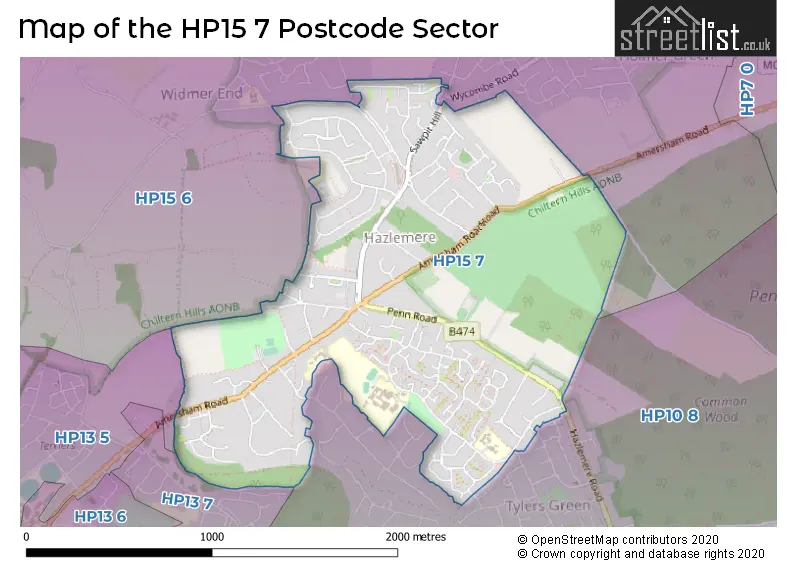
The HP15 7 Postcode shares a border with HP13 5 (HIGH WYCOMBE, Downley), HP13 7 (HIGH WYCOMBE), HP15 6 (Holmer Green, Great Kingshill, Widmer End) and HP10 8 (Penn).
The sector is within the post town of HIGH WYCOMBE.
HP15 7 is a postcode sector within the HP15 postcode district which is within the HP Hemel Hempstead postcode area.
The Royal Mail delivery office for the HP15 7 postal sector is the Hazlemere Delivery Office.
The area of the HP15 7 postcode sector is 1.32 square miles which is 3.43 square kilometres or 847.35 square acres.

Map of the HP15 7 Postcode Sector
Explore the HP15 7 postcode sector by using our free interactive map.
| H | P | 1 | 5 | - | 7 | X | X |
| H | P | 1 | 5 | Space | 7 | Letter | Letter |
Official List of Streets
Hazlemere (122 Streets)
Unofficial Streets or Alternative Spellings
Penn
ASHLEY DRIVE COPPICE FARM ROAD HAZLEMERE ROAD ASHFIELD CLOSE AZALEA CLOSE BIRCH WAY BLUEBELL WAY CHALK TRACK CRICKWELL WALK ELM CLOSE LIME CLOSE LOWFIELD CLOSE PINE CLOSE ROWAN CLOSE RUSHMOOR PATH SPINDLE CLOSE ST. JOHNS ROAD THE LINK THE RISE THE WATER GARDENSHolmer Green
WATCHET LANEWidmer End
BRIMMERS HILL PRIMROSE HILL SUNNY BANK YEW TREE DRIVEWeather Forecast for HP15 7
Press Button to Show Forecast for High Wycombe
| Time Period | Icon | Description | Temperature | Rain Probability | Wind |
|---|---|---|---|---|---|
| 21:00 to 00:00 | Clear night | 18.0°C (feels like 17.0°C) | 1.00% | S 4 mph |
Press Button to Show Forecast for High Wycombe
| Time Period | Icon | Description | Temperature | Rain Probability | Wind |
|---|---|---|---|---|---|
| 00:00 to 03:00 | Clear night | 15.0°C (feels like 14.0°C) | 2.00% | S 4 mph | |
| 03:00 to 06:00 | Partly cloudy (night) | 13.0°C (feels like 12.0°C) | 4.00% | SSW 7 mph | |
| 06:00 to 09:00 | Mist | 13.0°C (feels like 11.0°C) | 15.00% | S 9 mph | |
| 09:00 to 12:00 | Partly cloudy (day) | 16.0°C (feels like 14.0°C) | 1.00% | S 11 mph | |
| 12:00 to 15:00 | Cloudy | 19.0°C (feels like 16.0°C) | 3.00% | S 13 mph | |
| 15:00 to 18:00 | Cloudy | 19.0°C (feels like 16.0°C) | 5.00% | S 13 mph | |
| 18:00 to 21:00 | Cloudy | 18.0°C (feels like 15.0°C) | 8.00% | SSE 11 mph | |
| 21:00 to 00:00 | Cloudy | 16.0°C (feels like 14.0°C) | 27.00% | SE 9 mph |
Press Button to Show Forecast for High Wycombe
| Time Period | Icon | Description | Temperature | Rain Probability | Wind |
|---|---|---|---|---|---|
| 00:00 to 03:00 | Light rain | 15.0°C (feels like 13.0°C) | 50.00% | SE 9 mph | |
| 03:00 to 06:00 | Light rain | 14.0°C (feels like 12.0°C) | 61.00% | SE 9 mph | |
| 06:00 to 09:00 | Heavy rain | 14.0°C (feels like 12.0°C) | 83.00% | SE 9 mph | |
| 09:00 to 12:00 | Heavy rain | 14.0°C (feels like 13.0°C) | 85.00% | SE 9 mph | |
| 12:00 to 15:00 | Heavy rain | 15.0°C (feels like 13.0°C) | 80.00% | S 11 mph | |
| 15:00 to 18:00 | Cloudy | 15.0°C (feels like 13.0°C) | 22.00% | S 11 mph | |
| 18:00 to 21:00 | Cloudy | 15.0°C (feels like 13.0°C) | 14.00% | SSE 9 mph | |
| 21:00 to 00:00 | Cloudy | 13.0°C (feels like 12.0°C) | 7.00% | SE 9 mph |
Press Button to Show Forecast for High Wycombe
| Time Period | Icon | Description | Temperature | Rain Probability | Wind |
|---|---|---|---|---|---|
| 00:00 to 03:00 | Cloudy | 12.0°C (feels like 11.0°C) | 7.00% | SE 9 mph | |
| 03:00 to 06:00 | Partly cloudy (night) | 11.0°C (feels like 10.0°C) | 4.00% | SE 7 mph | |
| 06:00 to 09:00 | Partly cloudy (day) | 12.0°C (feels like 11.0°C) | 7.00% | SE 7 mph | |
| 09:00 to 12:00 | Partly cloudy (day) | 15.0°C (feels like 13.0°C) | 8.00% | SE 9 mph | |
| 12:00 to 15:00 | Partly cloudy (day) | 17.0°C (feels like 15.0°C) | 8.00% | SSE 11 mph | |
| 15:00 to 18:00 | Partly cloudy (day) | 18.0°C (feels like 16.0°C) | 6.00% | SSE 9 mph | |
| 18:00 to 21:00 | Sunny day | 16.0°C (feels like 15.0°C) | 4.00% | SSE 7 mph | |
| 21:00 to 00:00 | Clear night | 12.0°C (feels like 11.0°C) | 1.00% | SSE 7 mph |
Press Button to Show Forecast for High Wycombe
| Time Period | Icon | Description | Temperature | Rain Probability | Wind |
|---|---|---|---|---|---|
| 00:00 to 03:00 | Clear night | 11.0°C (feels like 10.0°C) | 1.00% | SSE 4 mph | |
| 03:00 to 06:00 | Clear night | 10.0°C (feels like 9.0°C) | 1.00% | SE 4 mph | |
| 06:00 to 09:00 | Partly cloudy (day) | 12.0°C (feels like 11.0°C) | 2.00% | ESE 4 mph | |
| 09:00 to 12:00 | Cloudy | 16.0°C (feels like 15.0°C) | 7.00% | SE 4 mph | |
| 12:00 to 15:00 | Cloudy | 18.0°C (feels like 17.0°C) | 10.00% | SSW 4 mph | |
| 15:00 to 18:00 | Light rain shower (day) | 18.0°C (feels like 17.0°C) | 34.00% | WSW 4 mph | |
| 18:00 to 21:00 | Light rain shower (day) | 16.0°C (feels like 16.0°C) | 34.00% | SW 4 mph | |
| 21:00 to 00:00 | Cloudy | 13.0°C (feels like 13.0°C) | 9.00% | NW 4 mph |
Schools and Places of Education Within the HP15 7 Postcode Sector
Cedar Park School & Nursery
Community school
Cedar Avenue, High Wycombe, Buckinghamshire, HP15 7EF
Head: Mr Luke Redman
Ofsted Rating: Good
Inspection: 2019-05-02 (1837 days ago)
Website: Visit Cedar Park School & Nursery Website
Phone: 01494711918
Number of Pupils: 229
Hazlemere Church of England Combined School
Voluntary aided school
Amersham Road, High Wycombe, Buckinghamshire, HP15 7PZ
Head: Mr Brian Daniels
Ofsted Rating: Good
Inspection: 2022-02-16 (816 days ago)
Website: Visit Hazlemere Church of England Combined School Website
Phone: 01494521420
Number of Pupils: 200
Manor Farm Community Infant School
Community school
Rose Avenue, High Wycombe, Buckinghamshire, HP15 7PH
Head: Janice Woodhead
Ofsted Rating: Good
Inspection: 2019-11-20 (1635 days ago)
Website: Visit Manor Farm Community Infant School Website
Phone: 01494814281
Number of Pupils: 165
House Prices in the HP15 7 Postcode Sector
| Type of Property | 2018 Average | 2018 Sales | 2017 Average | 2017 Sales | 2016 Average | 2016 Sales | 2015 Average | 2015 Sales |
|---|---|---|---|---|---|---|---|---|
| Detached | £601,618 | 42 | £652,120 | 51 | £605,184 | 35 | £538,964 | 50 |
| Semi-Detached | £435,621 | 49 | £445,951 | 41 | £431,977 | 51 | £385,697 | 56 |
| Terraced | £371,086 | 21 | £395,887 | 27 | £347,611 | 33 | £309,214 | 35 |
| Flats | £310,326 | 60 | £280,059 | 17 | £269,314 | 21 | £266,316 | 28 |
Important Postcodes HP15 7 in the Postcode Sector
HP15 7AD is the postcode for The Surgery, 2a Roberts Ride
HP15 7EF is the postcode for Cedar Park School, Cedar Avenue, and CEDAR PARK SCHOOL, CEDAR AVENUE, HAZLEMERE
HP15 7PH is the postcode for HALL AND CLASSROOM BLOCK, Manor Farm Community Junior School, Rose Avenue, Manor Farm Community Infant School, Rose Avenue, and MAIN SCHOOL BLOCK, Manor Farm Community Junior School, Rose Avenue
HP15 7PY is the postcode for Buckinghamshire County Council, Hazlemere Library, 312 Amersham Road
HP15 7PZ is the postcode for Hazlemere C of E School, 262 Amersham Road, and Hazlemere C of E School, 262 Amersham Road, Hazlemere
HP15 7QW is the postcode for Hazlemere Memorial Hall, Amersham Road
HP15 7UB is the postcode for Sir William Ramsay School, Rose Avenue, MAIN BUILDING, SIR WILLIAM RAMSAY SCHOOL, ROSE AVENUE, PERFORMING ARTS BUILDING, SIR WILLIAM RAMSAY SCHOOL, ROSE AVENUE, and MATHS & HUMANITIES BUILDING, Sir William Ramsay School, Rose Avenue
HP15 7UW is the postcode for Highfield Surgery, Highfield Way
| The HP15 7 Sector is within these Local Authorities |
|
|---|---|
| The HP15 7 Sector is within these Counties |
|
| The HP15 7 Sector is within these Water Company Areas |
|