The IP29 5 postcode sector is within the county of Suffolk.
Did you know? According to the 2021 Census, the IP29 5 postcode sector is home to a bustling 4,712 residents!
Given that each sector allows for 400 unique postcode combinations. Letters C, I, K, M, O and V are not allowed in the last two letters of a postcode. With 188 postcodes already in use, this leaves 212 units available.
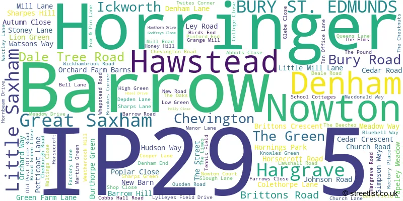
The largest settlement in the IP29 5 postal code is Barrow followed by Horringer, and Chevington.
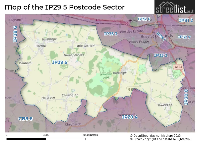
The IP29 5 Postcode shares a border with IP33 2 (BURY ST. EDMUNDS), IP33 3 (BURY ST. EDMUNDS, Westley), CB8 8 (NEWMARKET, Wickhambrook, Moulton), IP30 0 (Cockfield, Rattlesden, Great Whelnetham), IP28 6 (Risby, Barton Mills, Fornham All Saints) and IP29 4 (Lawshall, Chedburgh, Whepstead).
The sector is within the post town of BURY ST. EDMUNDS.
IP29 5 is a postcode sector within the IP2 postcode district which is within the IP Ipswich postcode area.
The Royal Mail delivery office for the IP29 5 postal sector is the unknown.
The area of the IP29 5 postcode sector is 25.00 square miles which is 64.74 square kilometres or 15,997.94 square acres.
Waterways within the IP29 5 postcode sector include the Lark.

Map of the IP29 5 Postcode Sector
Explore the IP29 5 postcode sector by using our free interactive map.
| I | P | 2 | 9 | - | 5 | X | X |
| I | P | 2 | 9 | Space | 5 | Letter | Letter |
Official List of Streets
Denham (4 Streets)
Barrow (36 Streets)
Chevington (19 Streets)
Great Saxham (4 Streets)
Hargrave (10 Streets)
Hawstead (7 Streets)
Nowton (6 Streets)
Horringer (23 Streets)
Little Saxham (1 Streets)
BURY ST. EDMUNDS (2 Streets)
Unofficial Streets or Alternative Spellings
BURY ST. EDMUNDS
HORRINGER ROAD NOWTON ROAD PLOVERS WAY SHARP ROAD SICKLESMERE ROAD ALBANA WALK ANDREWS YARD BELLS LANE BROCKLEY LANE BROOK CLOSE BULL LANE BURGATE ROAD COALPIT LANE DENHAM ROAD FOX AND PIN LANE GARRODS END GERALDINES WALK GYPSY LANE HAYSBORDER ROAD HEIGHAMS HENCOTE LANE HOWLETTS YARD LIME AVENUE LYLLES FIELD OAK WALK OLD TOWN LANE PARK LANE POULTERS LANE QUEENS HILL SAXHAM DRIVE SHAKERS ROAD SHARPES LANE SIMPSON DRIVE ST MARTINS PLACE THE ERSKINE WALK THEBEECHES TWITES CLOSESicklesmere
HAWSTEAD LANEWhepstead
CHEDBURGH ROADChedburgh
CHEVINGTON ROAD QUEENS LANEDalham
DENHAM ROADWeather Forecast for IP29 5
Press Button to Show Forecast for Brooms Barn
| Time Period | Icon | Description | Temperature | Rain Probability | Wind |
|---|---|---|---|---|---|
| 09:00 to 12:00 | Light rain | 11.0°C (feels like 8.0°C) | 57.00% | SSW 13 mph | |
| 12:00 to 15:00 | Light rain | 9.0°C (feels like 6.0°C) | 58.00% | WSW 16 mph | |
| 15:00 to 18:00 | Light rain | 8.0°C (feels like 5.0°C) | 56.00% | WSW 16 mph | |
| 18:00 to 21:00 | Cloudy | 9.0°C (feels like 6.0°C) | 11.00% | SW 11 mph | |
| 21:00 to 00:00 | Clear night | 7.0°C (feels like 5.0°C) | 1.00% | SSW 9 mph |
Press Button to Show Forecast for Brooms Barn
| Time Period | Icon | Description | Temperature | Rain Probability | Wind |
|---|---|---|---|---|---|
| 00:00 to 03:00 | Clear night | 6.0°C (feels like 3.0°C) | 1.00% | SSW 9 mph | |
| 03:00 to 06:00 | Clear night | 5.0°C (feels like 2.0°C) | 0.00% | SSW 7 mph | |
| 06:00 to 09:00 | Sunny day | 6.0°C (feels like 3.0°C) | 0.00% | S 9 mph | |
| 09:00 to 12:00 | Partly cloudy (day) | 12.0°C (feels like 9.0°C) | 0.00% | SSW 13 mph | |
| 12:00 to 15:00 | Cloudy | 14.0°C (feels like 11.0°C) | 5.00% | S 13 mph | |
| 15:00 to 18:00 | Partly cloudy (day) | 15.0°C (feels like 12.0°C) | 3.00% | S 16 mph | |
| 18:00 to 21:00 | Sunny day | 13.0°C (feels like 11.0°C) | 1.00% | S 11 mph | |
| 21:00 to 00:00 | Clear night | 9.0°C (feels like 7.0°C) | 1.00% | SSE 9 mph |
Press Button to Show Forecast for Brooms Barn
| Time Period | Icon | Description | Temperature | Rain Probability | Wind |
|---|---|---|---|---|---|
| 00:00 to 03:00 | Clear night | 8.0°C (feels like 6.0°C) | 1.00% | SE 7 mph | |
| 03:00 to 06:00 | Partly cloudy (night) | 7.0°C (feels like 5.0°C) | 1.00% | SE 7 mph | |
| 06:00 to 09:00 | Partly cloudy (day) | 9.0°C (feels like 7.0°C) | 2.00% | SE 7 mph | |
| 09:00 to 12:00 | Cloudy | 14.0°C (feels like 12.0°C) | 9.00% | SE 11 mph | |
| 12:00 to 15:00 | Cloudy | 16.0°C (feels like 13.0°C) | 12.00% | SE 13 mph | |
| 15:00 to 18:00 | Cloudy | 16.0°C (feels like 14.0°C) | 10.00% | SE 13 mph | |
| 18:00 to 21:00 | Cloudy | 15.0°C (feels like 13.0°C) | 11.00% | ESE 9 mph | |
| 21:00 to 00:00 | Cloudy | 11.0°C (feels like 10.0°C) | 16.00% | ESE 7 mph |
Press Button to Show Forecast for Brooms Barn
| Time Period | Icon | Description | Temperature | Rain Probability | Wind |
|---|---|---|---|---|---|
| 00:00 to 03:00 | Cloudy | 11.0°C (feels like 10.0°C) | 15.00% | ESE 7 mph | |
| 03:00 to 06:00 | Partly cloudy (night) | 10.0°C (feels like 9.0°C) | 10.00% | E 4 mph | |
| 06:00 to 09:00 | Cloudy | 11.0°C (feels like 10.0°C) | 10.00% | E 4 mph | |
| 09:00 to 12:00 | Partly cloudy (day) | 15.0°C (feels like 14.0°C) | 9.00% | SE 7 mph | |
| 12:00 to 15:00 | Partly cloudy (day) | 18.0°C (feels like 17.0°C) | 9.00% | ENE 9 mph | |
| 15:00 to 18:00 | Cloudy | 19.0°C (feels like 17.0°C) | 9.00% | NE 11 mph | |
| 18:00 to 21:00 | Cloudy | 16.0°C (feels like 15.0°C) | 6.00% | NNE 9 mph | |
| 21:00 to 00:00 | Cloudy | 12.0°C (feels like 11.0°C) | 7.00% | NE 7 mph |
Schools and Places of Education Within the IP29 5 Postcode Sector
Barrow Church of England Voluntary Controlled Primary School
Voluntary controlled school
Colethorpe Lane, Bury St Edmunds, Suffolk, IP29 5AU
Head: Mrs Helen Ashe
Ofsted Rating: Outstanding
Inspection: 2011-10-20 (4574 days ago)
Website: Visit Barrow Church of England Voluntary Controlled Primary School Website
Phone: 01284810223
Number of Pupils: 201
Ickworth Park Primary School
Community school
Meadow Drive, Bury St Edmunds, Suffolk, IP29 5SB
Head: Mrs Kirsten Steele
Ofsted Rating: Good
Inspection: 2019-06-18 (1776 days ago)
Website: Visit Ickworth Park Primary School Website
Phone: 01284735337
Number of Pupils: 197
House Prices in the IP29 5 Postcode Sector
| Type of Property | 2018 Average | 2018 Sales | 2017 Average | 2017 Sales | 2016 Average | 2016 Sales | 2015 Average | 2015 Sales |
|---|---|---|---|---|---|---|---|---|
| Detached | £521,842 | 32 | £441,091 | 43 | £413,489 | 66 | £426,531 | 51 |
| Semi-Detached | £330,325 | 10 | £270,648 | 20 | £267,745 | 19 | £271,851 | 22 |
| Terraced | £296,000 | 7 | £265,355 | 9 | £296,688 | 15 | £231,629 | 19 |
| Flats | £185,000 | 1 | £0 | 0 | £270,000 | 1 | £286,666 | 6 |
Important Postcodes IP29 5 in the Postcode Sector
IP29 5AU is the postcode for Barrow CEVC Primary School, Colethorpe Lane, Barrow, and Barrow C of E VC Primary School, Church Road
IP29 5SB is the postcode for Ickworth Park Primary School, Meadow Drive, Horringer, and Ickworth Park Primary School, Meadow Drive
| The IP29 5 Sector is within these Local Authorities |
|
|---|---|
| The IP29 5 Sector is within these Counties |
|
| The IP29 5 Sector is within these Water Company Areas |
|
Tourist Attractions within the IP29 5 Postcode Area
We found 1 visitor attractions within the IP2 postcode area
| Ickworth House, Park and Gardens |
|---|
| Historic Properties |
| Historic House / House and Garden / Palace |
| View Ickworth House, Park and Gardens on Google Maps |