The IP5 1 postcode sector is within the county of Suffolk.
Did you know? According to the 2021 Census, the IP5 1 postcode sector is home to a bustling 5,380 residents!
Given that each sector allows for 400 unique postcode combinations. Letters C, I, K, M, O and V are not allowed in the last two letters of a postcode. With 146 postcodes already in use, this leaves 254 units available.
The largest settlements in the IP5 1 postal code are Kesgrave and Rushmere St. Andrew.
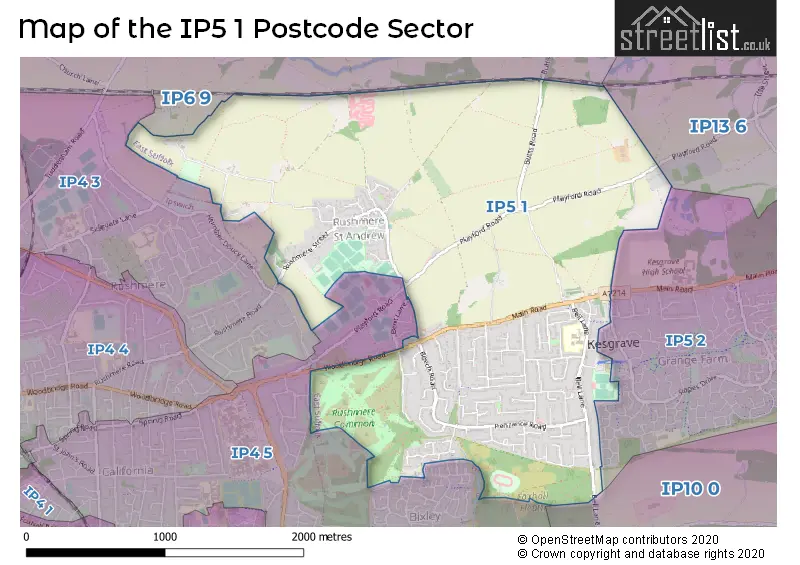
The IP5 1 Postcode shares a border with IP4 5 (IPSWICH, Rushmere St. Andrew), IP6 9 (Otley, Witnesham, Coddenham), IP13 6 (Grundisburgh, Ufford, Hasketon), IP4 3 (IPSWICH), IP5 2 (Kesgrave) and IP10 0 (Nacton, Kirton, Bucklesham).
The sector is within the post town of IPSWICH.
IP5 1 is a postcode sector within the IP4 postcode district which is within the IP Ipswich postcode area.
The Royal Mail delivery office for the IP5 1 postal sector is the Ipswich Delivery Office.
The area of the IP5 1 postcode sector is 2.66 square miles which is 6.89 square kilometres or 1,701.93 square acres.

Map of the IP5 1 Postcode Sector
Explore the IP5 1 postcode sector by using our free interactive map.
| I | P | 5 | - | 1 | X | X |
| I | P | 5 | Space | 1 | Letter | Letter |
Official List of Streets
Kesgrave (46 Streets)
Rushmere St. Andrew (32 Streets)
Unofficial Streets or Alternative Spellings
Kesgrave
FERGUSON WAY ROPES DRIVE SEWELL WONTNER CLOSE ALL SAINTS ROUNDABOUT BEECHWOOD DRIVE BOUNDARY WALK BROADLANDS WALK DITCHINGHAM CLOSE FARTHING WALK HEATH WALK KESGRAVE BUSWAY LANKESTER WAY LINKSFIELD WALK LONG STROPS BRIDLEWAY LONG WOOD PATH PILBROUGHS WALK PINETREE CLOSE POND WALK RUSHMERE ST ANDREWS 53 RUSHMERE STREET RUSHMERE WALK THE BACKS TRAFALGAR WALK YEWTREE GROVERushmere St. Andrew
BENT LANE BROADLANDS WAY HAUGHLEY DRIVELittle Bealings
PLAYFORD ROADPlayford
BUTTS ROADIPSWICH
WOODBRIDGE ROAD EASTSchools and Places of Education Within the IP5 1 Postcode Sector
Heath Primary School, Kesgrave
Community school
Bell Lane, Ipswich, Suffolk, IP5 1JG
Head: Mr David Whatley
Ofsted Rating: Good
Inspection: 2023-05-17 (378 days ago)
Website: Visit Heath Primary School, Kesgrave Website
Phone: 01473622806
Number of Pupils: 572
House Prices in the IP5 1 Postcode Sector
| Type of Property | 2018 Average | 2018 Sales | 2017 Average | 2017 Sales | 2016 Average | 2016 Sales | 2015 Average | 2015 Sales |
|---|---|---|---|---|---|---|---|---|
| Detached | £349,905 | 41 | £398,103 | 46 | £337,389 | 36 | £314,719 | 39 |
| Semi-Detached | £245,577 | 26 | £258,735 | 34 | £251,204 | 38 | £215,963 | 34 |
| Terraced | £193,313 | 8 | £224,663 | 11 | £193,000 | 2 | £188,318 | 11 |
| Flats | £149,950 | 1 | £0 | 0 | £147,000 | 1 | £104,749 | 4 |
Important Postcodes IP5 1 in the Postcode Sector
IP5 1JF is the postcode for Grange Lodge, Twelve Acre Approach, and The Birches Medical Centre, Twelve Acre Approach
IP5 1JG is the postcode for Heath Primary School, Bell Lane, Kesgrave, and Heath Primary School, Bell Lane
| The IP5 1 Sector is within these Local Authorities |
|
|---|---|
| The IP5 1 Sector is within these Counties |
|
| The IP5 1 Sector is within these Water Company Areas |
|