The L11 1 postcode sector is within the county of Merseyside.
Did you know? According to the 2021 Census, the L11 1 postcode sector is home to a bustling 4,899 residents!
Given that each sector allows for 400 unique postcode combinations. Letters C, I, K, M, O and V are not allowed in the last two letters of a postcode. With 79 postcodes already in use, this leaves 321 units available.
The largest settlements in the L11 1 postal code are LIVERPOOL and Norris Green.
The L11 1 Postcode shares a border with L12 5 (LIVERPOOL, West Derby), L11 2 (LIVERPOOL, West Derby), L11 3 (LIVERPOOL), L11 5 (LIVERPOOL, Norris Green), L11 8 (LIVERPOOL, Norris Green, West Derby), L12 0 (LIVERPOOL, West Derby) and L13 0 (LIVERPOOL, West Derby, Stoneycroft).
The sector is within the post town of LIVERPOOL.
L11 1 is a postcode sector within the L1 postcode district which is within the L Liverpool postcode area.
The Royal Mail delivery office for the L11 1 postal sector is the Liverpool 1-3.
The area of the L11 1 postcode sector is 0.37 square miles which is 0.96 square kilometres or 236.05 square acres.

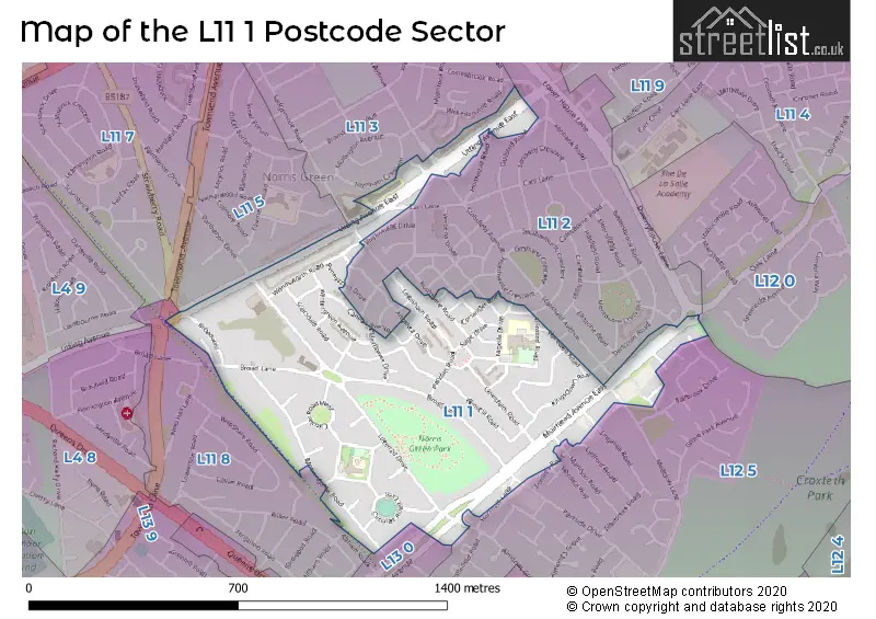
Map of the L11 1 Postcode Sector
Explore the L11 1 postcode sector by using our free interactive map.
| L | 1 | 1 | - | 1 | X | X |
| L | 1 | 1 | Space | 1 | Letter | Letter |
Official List of Streets
Norris Green (2 Streets)
LIVERPOOL (34 Streets)
Unofficial Streets or Alternative Spellings
LIVERPOOL
ANGELICA DRIVE BRIDGEWAY BROOKLIME ROAD CAMPHOR WAY CORIANDER ROAD DEANSCALES ROAD FALLBROOK DRIVE FORDLEA ROAD FORDLEA WAY FRINSTED ROAD GUILSTED ROAD HOMESTALL ROAD HORNSPIT LANE KAMALA WAY KERMAN CLOSE LINGMELL ROAD LYDFORD ROAD MARLDON ROAD MUIRHEAD AVENUE NIGELLA DRIVE PAPRIKA DRIVE PARKSIDE DRIVE PENNYCRESS DRIVE PEPPERMINT WAY RUSHMERE ROAD SCARGREEN AVENUE SORREL AVENUE STALISFIELD AVENUEWest Derby
CARR LANE MEADOW LANE ALLIUM WAY ALMONDS GREEN BYRONY ROAD HAREWELL ROAD LIVERPOOL LOOP LINE NUTMEG WAY QUINCE WAY SAGE DRIVE SORRELL AVENUEClubmoor
TOWNSEND AVENUEWeather Forecast for L11 1
Press Button to Show Forecast for West Derby
| Time Period | Icon | Description | Temperature | Rain Probability | Wind |
|---|---|---|---|---|---|
| 06:00 to 09:00 | Cloudy | 10.0°C (feels like 6.0°C) | 5.00% | SE 16 mph | |
| 09:00 to 12:00 | Cloudy | 12.0°C (feels like 8.0°C) | 8.00% | SE 18 mph | |
| 12:00 to 15:00 | Cloudy | 15.0°C (feels like 11.0°C) | 9.00% | SSE 18 mph | |
| 15:00 to 18:00 | Cloudy | 15.0°C (feels like 12.0°C) | 15.00% | SSE 16 mph | |
| 18:00 to 21:00 | Light rain shower (day) | 13.0°C (feels like 11.0°C) | 35.00% | SSE 11 mph | |
| 21:00 to 00:00 | Cloudy | 12.0°C (feels like 10.0°C) | 16.00% | SE 9 mph |
Press Button to Show Forecast for West Derby
| Time Period | Icon | Description | Temperature | Rain Probability | Wind |
|---|---|---|---|---|---|
| 00:00 to 03:00 | Cloudy | 10.0°C (feels like 9.0°C) | 9.00% | SE 7 mph | |
| 03:00 to 06:00 | Cloudy | 9.0°C (feels like 8.0°C) | 4.00% | SE 7 mph | |
| 06:00 to 09:00 | Cloudy | 9.0°C (feels like 7.0°C) | 4.00% | SE 7 mph | |
| 09:00 to 12:00 | Cloudy | 11.0°C (feels like 10.0°C) | 5.00% | ESE 7 mph | |
| 12:00 to 15:00 | Cloudy | 14.0°C (feels like 13.0°C) | 8.00% | SE 7 mph | |
| 15:00 to 18:00 | Cloudy | 15.0°C (feels like 14.0°C) | 13.00% | SSE 7 mph | |
| 18:00 to 21:00 | Cloudy | 14.0°C (feels like 13.0°C) | 12.00% | WNW 7 mph | |
| 21:00 to 00:00 | Cloudy | 13.0°C (feels like 12.0°C) | 11.00% | NW 7 mph |
Press Button to Show Forecast for West Derby
| Time Period | Icon | Description | Temperature | Rain Probability | Wind |
|---|---|---|---|---|---|
| 00:00 to 03:00 | Cloudy | 12.0°C (feels like 10.0°C) | 12.00% | NNW 7 mph | |
| 03:00 to 06:00 | Cloudy | 11.0°C (feels like 10.0°C) | 9.00% | NNW 7 mph | |
| 06:00 to 09:00 | Cloudy | 11.0°C (feels like 10.0°C) | 7.00% | NNW 7 mph | |
| 09:00 to 12:00 | Partly cloudy (day) | 13.0°C (feels like 11.0°C) | 5.00% | N 9 mph | |
| 12:00 to 15:00 | Sunny day | 16.0°C (feels like 14.0°C) | 5.00% | N 9 mph | |
| 15:00 to 18:00 | Sunny day | 17.0°C (feels like 15.0°C) | 3.00% | N 11 mph | |
| 18:00 to 21:00 | Sunny day | 17.0°C (feels like 14.0°C) | 4.00% | N 11 mph | |
| 21:00 to 00:00 | Clear night | 14.0°C (feels like 12.0°C) | 3.00% | NNE 9 mph |
Schools and Places of Education Within the L11 1 Postcode Sector
Broad Square Community Primary School
Community school
Broad Square, Liverpool, Merseyside, L11 1BS
Head: Mrs Charlotte Foden
Ofsted Rating: Good
Inspection: 2018-11-01 (2007 days ago)
Website: Visit Broad Square Community Primary School Website
Phone: 01512261117
Number of Pupils: 420
Monksdown Primary School
Community school
Monksdown Road, Liverpool, Merseyside, L11 1HH
Head: Mrs Jacquie Price
Ofsted Rating: Good
Inspection: 2023-10-18 (195 days ago)
Website: Visit Monksdown Primary School Website
Phone: 01512261606
Number of Pupils: 645
House Prices in the L11 1 Postcode Sector
| Type of Property | 2018 Average | 2018 Sales | 2017 Average | 2017 Sales | 2016 Average | 2016 Sales | 2015 Average | 2015 Sales |
|---|---|---|---|---|---|---|---|---|
| Detached | £188,546 | 8 | £178,440 | 45 | £169,026 | 28 | £143,086 | 11 |
| Semi-Detached | £140,426 | 51 | £153,541 | 96 | £138,833 | 69 | £125,645 | 23 |
| Terraced | £97,077 | 13 | £92,704 | 29 | £101,916 | 24 | £100,414 | 24 |
| Flats | £0 | 0 | £0 | 0 | £68,500 | 1 | £129,000 | 1 |
Important Postcodes L11 1 in the Postcode Sector
L11 1BS is the postcode for Broad Square Primary School, Broad Square, BROAD SQUARE PRIMARY SCHOOL, BROAD SQUARE, LIVERPOOL, and Broad Square Cp School, Broad Square
L11 1DB is the postcode for St. Teresa of Lisieux RC Primary School, 163 Utting Avenue East
L11 1DQ is the postcode for Clubmoor Childrens Centre, Utting Avenue East
L11 1HH is the postcode for MONKSDOWN PRIMARY SCHOOL, MONKSDOWN ROAD, LIVERPOOL, and Monksdown Primary School, Monksdown Road
| The L11 1 Sector is within these Local Authorities |
|
|---|---|
| The L11 1 Sector is within these Counties |
|
| The L11 1 Sector is within these Water Company Areas |
|