The L12 7 postcode sector is within the county of Merseyside.
Did you know? According to the 2021 Census, the L12 7 postcode sector is home to a bustling 2,562 residents!
Given that each sector allows for 400 unique postcode combinations. Letters C, I, K, M, O and V are not allowed in the last two letters of a postcode. With 56 postcodes already in use, this leaves 344 units available.
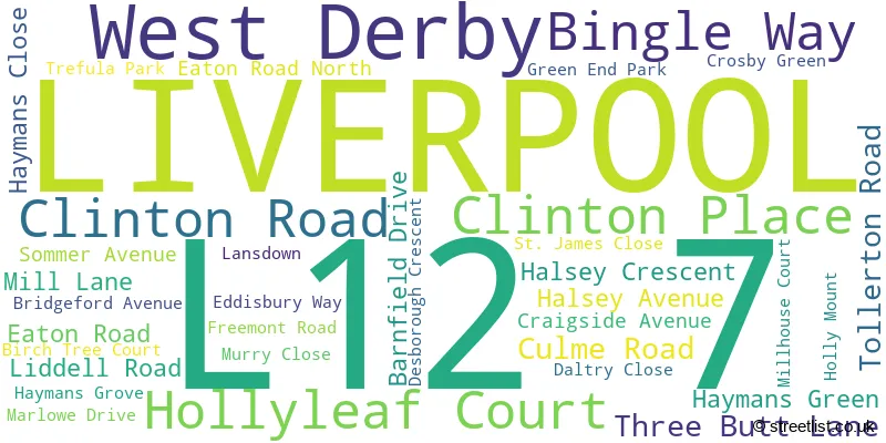
The largest settlements in the L12 7 postal code are LIVERPOOL and West Derby.
The L12 7 Postcode shares a border with L12 1 (LIVERPOOL, West Derby, Sandfield Park), L12 5 (LIVERPOOL, West Derby), L12 8 (LIVERPOOL, West Derby) and L13 0 (LIVERPOOL, West Derby, Stoneycroft).
The sector is within the post town of LIVERPOOL.
L12 7 is a postcode sector within the L1 postcode district which is within the L Liverpool postcode area.
The Royal Mail delivery office for the L12 7 postal sector is the Liverpool 1-3.
The area of the L12 7 postcode sector is 0.21 square miles which is 0.56 square kilometres or 137.45 square acres.

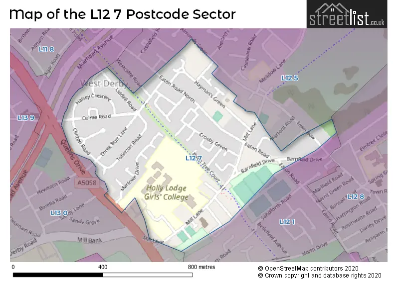
Map of the L12 7 Postcode Sector
Explore the L12 7 postcode sector by using our free interactive map.
| L | 1 | 2 | - | 7 | X | X |
| L | 1 | 2 | Space | 7 | Letter | Letter |
Official List of Streets
LIVERPOOL (31 Streets)
Unofficial Streets or Alternative Spellings
LIVERPOOL
MARFORD ROAD TOWN ROW WESTCLIFFE ROAD BYRON AVENUE LIVERPOOL LOOP LINE SAINT JAMES CLOSEStoneycroft
QUEENS DRIVEWeather Forecast for L12 7
Press Button to Show Forecast for West Derby
| Time Period | Icon | Description | Temperature | Rain Probability | Wind |
|---|---|---|---|---|---|
| 00:00 to 03:00 | Cloudy | 10.0°C (feels like 8.0°C) | 10.00% | SSE 13 mph | |
| 03:00 to 06:00 | Cloudy | 10.0°C (feels like 7.0°C) | 7.00% | SSE 16 mph | |
| 06:00 to 09:00 | Cloudy | 10.0°C (feels like 6.0°C) | 5.00% | SE 16 mph | |
| 09:00 to 12:00 | Cloudy | 12.0°C (feels like 8.0°C) | 8.00% | SE 18 mph | |
| 12:00 to 15:00 | Cloudy | 15.0°C (feels like 11.0°C) | 9.00% | SSE 18 mph | |
| 15:00 to 18:00 | Cloudy | 15.0°C (feels like 12.0°C) | 15.00% | SSE 16 mph | |
| 18:00 to 21:00 | Light rain shower (day) | 13.0°C (feels like 11.0°C) | 35.00% | SSE 11 mph | |
| 21:00 to 00:00 | Cloudy | 12.0°C (feels like 10.0°C) | 16.00% | SE 9 mph |
Press Button to Show Forecast for West Derby
| Time Period | Icon | Description | Temperature | Rain Probability | Wind |
|---|---|---|---|---|---|
| 00:00 to 03:00 | Cloudy | 10.0°C (feels like 9.0°C) | 9.00% | SE 7 mph | |
| 03:00 to 06:00 | Cloudy | 9.0°C (feels like 8.0°C) | 4.00% | SE 7 mph | |
| 06:00 to 09:00 | Cloudy | 9.0°C (feels like 7.0°C) | 4.00% | SE 7 mph | |
| 09:00 to 12:00 | Cloudy | 11.0°C (feels like 10.0°C) | 5.00% | ESE 7 mph | |
| 12:00 to 15:00 | Cloudy | 14.0°C (feels like 13.0°C) | 8.00% | SE 7 mph | |
| 15:00 to 18:00 | Cloudy | 15.0°C (feels like 14.0°C) | 13.00% | SSE 7 mph | |
| 18:00 to 21:00 | Cloudy | 14.0°C (feels like 13.0°C) | 12.00% | WNW 7 mph | |
| 21:00 to 00:00 | Cloudy | 13.0°C (feels like 12.0°C) | 11.00% | NW 7 mph |
Press Button to Show Forecast for West Derby
| Time Period | Icon | Description | Temperature | Rain Probability | Wind |
|---|---|---|---|---|---|
| 00:00 to 03:00 | Cloudy | 12.0°C (feels like 10.0°C) | 12.00% | NNW 7 mph | |
| 03:00 to 06:00 | Cloudy | 11.0°C (feels like 10.0°C) | 9.00% | NNW 7 mph | |
| 06:00 to 09:00 | Cloudy | 11.0°C (feels like 10.0°C) | 7.00% | NNW 7 mph | |
| 09:00 to 12:00 | Partly cloudy (day) | 13.0°C (feels like 11.0°C) | 5.00% | N 9 mph | |
| 12:00 to 15:00 | Sunny day | 16.0°C (feels like 14.0°C) | 5.00% | N 9 mph | |
| 15:00 to 18:00 | Sunny day | 17.0°C (feels like 15.0°C) | 3.00% | N 11 mph | |
| 18:00 to 21:00 | Sunny day | 17.0°C (feels like 14.0°C) | 4.00% | N 11 mph | |
| 21:00 to 00:00 | Clear night | 14.0°C (feels like 12.0°C) | 3.00% | NNE 9 mph |
Schools and Places of Education Within the L12 7 Postcode Sector
Holly Lodge Girls' College
Community school
140 Mill Lane, Liverpool, Merseyside, L12 7LE
Head: Mr Andrew Keen
Ofsted Rating: Good
Inspection: 2019-11-06 (1637 days ago)
Website: Visit Holly Lodge Girls' College Website
Phone: 01512283772
Number of Pupils: 956
House Prices in the L12 7 Postcode Sector
| Type of Property | 2018 Average | 2018 Sales | 2017 Average | 2017 Sales | 2016 Average | 2016 Sales | 2015 Average | 2015 Sales |
|---|---|---|---|---|---|---|---|---|
| Detached | £330,524 | 18 | £285,458 | 13 | £242,900 | 5 | £190,917 | 6 |
| Semi-Detached | £197,325 | 26 | £155,776 | 32 | £126,885 | 20 | £132,000 | 11 |
| Terraced | £175,348 | 20 | £119,700 | 14 | £106,030 | 15 | £114,455 | 11 |
| Flats | £88,667 | 3 | £97,520 | 5 | £0 | 0 | £87,500 | 1 |
Important Postcodes L12 7 in the Postcode Sector
L12 7JA is the postcode for Ernest Cookson Special School, Mill Lane
L12 7LE is the postcode for RESTAURANT AND KITCHEN BUILDING, Holly Lodge Girls College, 140 Mill Lane, ROSALIND FRANKLIN BUILDING, Holly Lodge Girls College, 140 Mill Lane, ROSA PARKS BUILDING, Holly Lodge Girls College, 140 Mill Lane, EMMELINE PANKHURST BUILDING, Holly lodge Girls College, 140 Mill Lane, ADA LOVELACE BUILDING, Holly Lodge Girls College, 140 Mill Lane, TURNER BUILDING, Holly lodge Girls College, 140 Mill Lane, PAVILION BUILDING, Holly Lodge Girls College, 140 Mill Lane, and ALEXANDRA BUILDING, Holly Lodge Girls College, 140 Mill Lane
| The L12 7 Sector is within these Local Authorities |
|
|---|---|
| The L12 7 Sector is within these Counties |
|
| The L12 7 Sector is within these Water Company Areas |
|