The L12 8 postcode sector is within the county of Merseyside.
Did you know? According to the 2021 Census, the L12 8 postcode sector is home to a bustling 2,790 residents!
Given that each sector allows for 400 unique postcode combinations. Letters C, I, K, M, O and V are not allowed in the last two letters of a postcode. With 50 postcodes already in use, this leaves 350 units available.
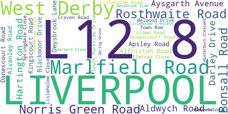
The largest settlements in the L12 8 postal code are LIVERPOOL and West Derby.
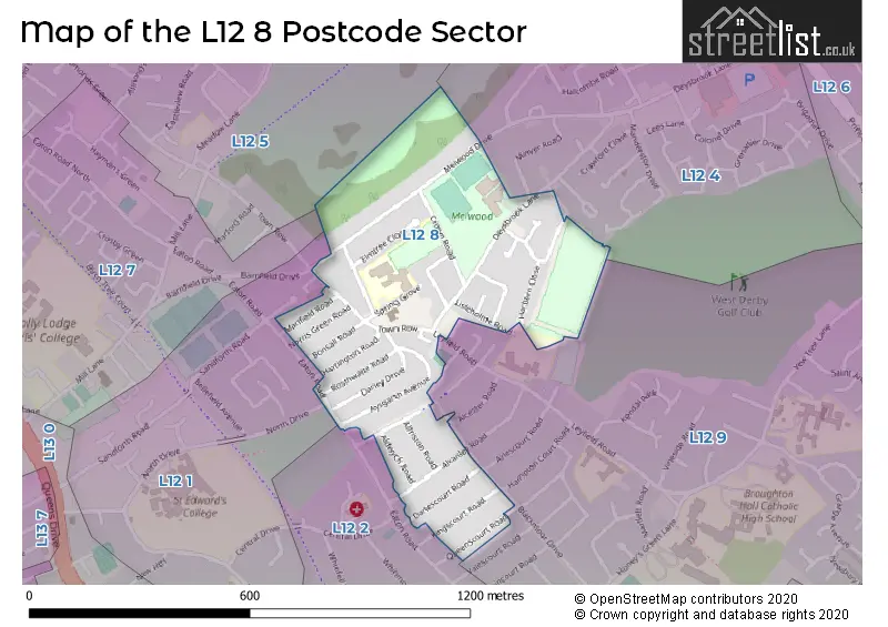
The L12 8 Postcode shares a border with L12 4 (LIVERPOOL, West Derby), L12 1 (LIVERPOOL, West Derby, Sandfield Park), L12 5 (LIVERPOOL, West Derby), L12 7 (LIVERPOOL, West Derby), L12 9 (LIVERPOOL, West Derby) and L12 2 (West Derby, LIVERPOOL, Sandfield Park).
The sector is within the post town of LIVERPOOL.
L12 8 is a postcode sector within the L12 postcode district which is within the L Liverpool postcode area.
The Royal Mail delivery office for the L12 8 postal sector is the West Derby Delivery Office.
The area of the L12 8 postcode sector is 0.20 square miles which is 0.52 square kilometres or 128.79 square acres.

Map of the L12 8 Postcode Sector
Explore the L12 8 postcode sector by using our free interactive map.
| L | 1 | 2 | - | 8 | X | X |
| L | 1 | 2 | Space | 8 | Letter | Letter |
Official List of Streets
LIVERPOOL (29 Streets)
West Derby (2 Streets)
Unofficial Streets or Alternative Spellings
LIVERPOOL
ALCESTER ROAD ARLESCOURT ROAD BARNFIELD CLOSE BEVANS LANE HAMPTON COURT ROAD LEYFIELD ROADSandfield Park
NORTH DRIVEWest Derby
EATON ROAD APPSLEY ROAD NORTH PARKSIDE DRIVE THORNHEAD LANEWeather Forecast for L12 8
Press Button to Show Forecast for West Derby
| Time Period | Icon | Description | Temperature | Rain Probability | Wind |
|---|---|---|---|---|---|
| 00:00 to 03:00 | Cloudy | 6.0°C (feels like 4.0°C) | 5.00% | E 7 mph | |
| 03:00 to 06:00 | Partly cloudy (night) | 5.0°C (feels like 3.0°C) | 2.00% | ENE 7 mph | |
| 06:00 to 09:00 | Partly cloudy (day) | 5.0°C (feels like 3.0°C) | 2.00% | ENE 7 mph | |
| 09:00 to 12:00 | Cloudy | 8.0°C (feels like 6.0°C) | 6.00% | E 9 mph | |
| 12:00 to 15:00 | Overcast | 10.0°C (feels like 8.0°C) | 10.00% | E 9 mph | |
| 15:00 to 18:00 | Light rain | 10.0°C (feels like 8.0°C) | 47.00% | E 9 mph | |
| 18:00 to 21:00 | Overcast | 9.0°C (feels like 7.0°C) | 42.00% | NE 9 mph | |
| 21:00 to 00:00 | Cloudy | 8.0°C (feels like 6.0°C) | 5.00% | NE 7 mph |
Press Button to Show Forecast for West Derby
| Time Period | Icon | Description | Temperature | Rain Probability | Wind |
|---|---|---|---|---|---|
| 00:00 to 03:00 | Cloudy | 7.0°C (feels like 4.0°C) | 4.00% | NNE 7 mph | |
| 03:00 to 06:00 | Cloudy | 6.0°C (feels like 3.0°C) | 4.00% | NNE 7 mph | |
| 06:00 to 09:00 | Cloudy | 6.0°C (feels like 3.0°C) | 8.00% | N 9 mph | |
| 09:00 to 12:00 | Cloudy | 8.0°C (feels like 5.0°C) | 10.00% | NNW 9 mph | |
| 12:00 to 15:00 | Cloudy | 10.0°C (feels like 7.0°C) | 12.00% | NW 11 mph | |
| 15:00 to 18:00 | Sunny day | 10.0°C (feels like 8.0°C) | 8.00% | WNW 13 mph | |
| 18:00 to 21:00 | Sunny day | 10.0°C (feels like 8.0°C) | 3.00% | W 11 mph | |
| 21:00 to 00:00 | Clear night | 9.0°C (feels like 7.0°C) | 2.00% | SW 11 mph |
Press Button to Show Forecast for West Derby
| Time Period | Icon | Description | Temperature | Rain Probability | Wind |
|---|---|---|---|---|---|
| 00:00 to 03:00 | Clear night | 8.0°C (feels like 5.0°C) | 1.00% | SSW 9 mph | |
| 03:00 to 06:00 | Cloudy | 7.0°C (feels like 4.0°C) | 5.00% | S 9 mph | |
| 06:00 to 09:00 | Cloudy | 7.0°C (feels like 3.0°C) | 7.00% | SSE 11 mph | |
| 09:00 to 12:00 | Partly cloudy (day) | 10.0°C (feels like 7.0°C) | 2.00% | SSE 13 mph | |
| 12:00 to 15:00 | Overcast | 13.0°C (feels like 10.0°C) | 10.00% | S 16 mph | |
| 15:00 to 18:00 | Cloudy | 13.0°C (feels like 10.0°C) | 9.00% | S 16 mph | |
| 18:00 to 21:00 | Cloudy | 13.0°C (feels like 10.0°C) | 8.00% | SSE 16 mph | |
| 21:00 to 00:00 | Partly cloudy (night) | 11.0°C (feels like 9.0°C) | 3.00% | SSE 13 mph |
Press Button to Show Forecast for West Derby
| Time Period | Icon | Description | Temperature | Rain Probability | Wind |
|---|---|---|---|---|---|
| 00:00 to 03:00 | Partly cloudy (night) | 10.0°C (feels like 7.0°C) | 4.00% | SE 13 mph | |
| 03:00 to 06:00 | Cloudy | 9.0°C (feels like 6.0°C) | 6.00% | SE 13 mph | |
| 06:00 to 09:00 | Cloudy | 9.0°C (feels like 6.0°C) | 6.00% | SE 13 mph | |
| 09:00 to 12:00 | Cloudy | 12.0°C (feels like 9.0°C) | 7.00% | SE 13 mph | |
| 12:00 to 15:00 | Partly cloudy (day) | 15.0°C (feels like 12.0°C) | 5.00% | SE 16 mph | |
| 15:00 to 18:00 | Cloudy | 16.0°C (feels like 13.0°C) | 14.00% | SE 13 mph | |
| 18:00 to 21:00 | Partly cloudy (day) | 15.0°C (feels like 13.0°C) | 6.00% | SE 11 mph | |
| 21:00 to 00:00 | Cloudy | 13.0°C (feels like 11.0°C) | 8.00% | ESE 9 mph |
Schools and Places of Education Within the L12 8 Postcode Sector
St Paul's and St Timothy's Catholic Infant School
Voluntary aided school
South Parkside Drive, Liverpool, Merseyside, L12 8RP
Head: Mrs Joanne Starkey
Ofsted Rating: Good
Inspection: 2019-10-10 (1661 days ago)
Website: Visit St Paul's and St Timothy's Catholic Infant School Website
Phone: 01512282114
Number of Pupils: 360
St Paul's Catholic Junior School
Voluntary aided school
Spring Grove, Liverpool, Merseyside, L12 8SJ
Head: Mr Jamie Luck
Ofsted Rating: Good
Inspection: 2021-09-15 (955 days ago)
Website: Visit St Paul's Catholic Junior School Website
Phone: 01512281159
Number of Pupils: 491
House Prices in the L12 8 Postcode Sector
| Type of Property | 2018 Average | 2018 Sales | 2017 Average | 2017 Sales | 2016 Average | 2016 Sales | 2015 Average | 2015 Sales |
|---|---|---|---|---|---|---|---|---|
| Detached | £114,000 | 1 | £210,250 | 2 | £184,500 | 2 | £125,000 | 1 |
| Semi-Detached | £171,171 | 21 | £166,505 | 27 | £140,945 | 20 | £143,088 | 17 |
| Terraced | £122,160 | 15 | £134,121 | 22 | £113,753 | 16 | £119,875 | 16 |
| Flats | £120,000 | 1 | £83,750 | 4 | £64,367 | 3 | £76,000 | 3 |
Important Postcodes L12 8 in the Postcode Sector
L12 8RP is the postcode for St. Pauls & St. Timothys Infant School, South Parkside Drive, and St Pauls And St Timothys Catholic Infants School, South Parkside Drive
L12 8SJ is the postcode for St. Pauls Catholic Junior School, Spring Grove
L12 8TQ is the postcode for West Derby Medical Centre, 3 Winterburn Crescent
| The L12 8 Sector is within these Local Authorities |
|
|---|---|
| The L12 8 Sector is within these Counties |
|
| The L12 8 Sector is within these Water Company Areas |
|