The L17 3 postcode sector is within the county of Merseyside.
Did you know? According to the 2021 Census, the L17 3 postcode sector is home to a bustling 2,040 residents!
Given that each sector allows for 400 unique postcode combinations. Letters C, I, K, M, O and V are not allowed in the last two letters of a postcode. With 35 postcodes already in use, this leaves 365 units available.
The largest settlements in the L17 3 postal code are LIVERPOOL and Sefton Park.
The L17 3 Postcode shares a border with L17 1 (LIVERPOOL, Sefton Park), L17 8 (LIVERPOOL, Aigburth, Sefton Park), L17 2 (LIVERPOOL, Sefton Park), L17 4 (LIVERPOOL, Aigburth), L8 0 (LIVERPOOL, Toxteth), L8 3 (LIVERPOOL, Princes Park, Dingle) and L15 2 (LIVERPOOL, Wavertree).
The sector is within the post town of LIVERPOOL.
L17 3 is a postcode sector within the L17 postcode district which is within the L Liverpool postcode area.
The Royal Mail delivery office for the L17 3 postal sector is the Lark Lane Delivery Office.
The area of the L17 3 postcode sector is 0.25 square miles which is 0.64 square kilometres or 159.18 square acres.

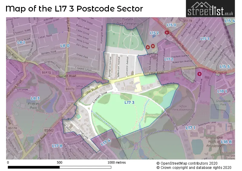
Map of the L17 3 Postcode Sector
Explore the L17 3 postcode sector by using our free interactive map.
| L | 1 | 7 | - | 3 | X | X |
| L | 1 | 7 | Space | 3 | Letter | Letter |
Official List of Streets
LIVERPOOL (10 Streets)
Sefton Park (2 Streets)
Unofficial Streets or Alternative Spellings
Weather Forecast for L17 3
Press Button to Show Forecast for Wavertree
| Time Period | Icon | Description | Temperature | Rain Probability | Wind |
|---|---|---|---|---|---|
| 06:00 to 09:00 | Sunny day | 4.0°C (feels like 2.0°C) | 1.00% | E 4 mph | |
| 09:00 to 12:00 | Partly cloudy (day) | 7.0°C (feels like 5.0°C) | 1.00% | E 4 mph | |
| 12:00 to 15:00 | Cloudy | 9.0°C (feels like 8.0°C) | 6.00% | NNE 4 mph | |
| 15:00 to 18:00 | Cloudy | 9.0°C (feels like 8.0°C) | 6.00% | N 4 mph | |
| 18:00 to 21:00 | Cloudy | 9.0°C (feels like 8.0°C) | 6.00% | NNE 7 mph | |
| 21:00 to 00:00 | Cloudy | 7.0°C (feels like 5.0°C) | 8.00% | NE 7 mph |
Press Button to Show Forecast for Wavertree
| Time Period | Icon | Description | Temperature | Rain Probability | Wind |
|---|---|---|---|---|---|
| 00:00 to 03:00 | Partly cloudy (night) | 5.0°C (feels like 3.0°C) | 6.00% | ESE 7 mph | |
| 03:00 to 06:00 | Partly cloudy (night) | 4.0°C (feels like 2.0°C) | 7.00% | ESE 7 mph | |
| 06:00 to 09:00 | Partly cloudy (day) | 4.0°C (feels like 2.0°C) | 5.00% | E 7 mph | |
| 09:00 to 12:00 | Partly cloudy (day) | 8.0°C (feels like 6.0°C) | 5.00% | ESE 7 mph | |
| 12:00 to 15:00 | Overcast | 10.0°C (feels like 8.0°C) | 14.00% | E 7 mph | |
| 15:00 to 18:00 | Light rain | 10.0°C (feels like 9.0°C) | 46.00% | NE 7 mph | |
| 18:00 to 21:00 | Cloudy | 10.0°C (feels like 8.0°C) | 15.00% | ENE 9 mph | |
| 21:00 to 00:00 | Partly cloudy (night) | 8.0°C (feels like 6.0°C) | 13.00% | NE 9 mph |
Press Button to Show Forecast for Wavertree
| Time Period | Icon | Description | Temperature | Rain Probability | Wind |
|---|---|---|---|---|---|
| 00:00 to 03:00 | Cloudy | 6.0°C (feels like 4.0°C) | 17.00% | NE 9 mph | |
| 03:00 to 06:00 | Cloudy | 6.0°C (feels like 3.0°C) | 16.00% | NNE 9 mph | |
| 06:00 to 09:00 | Light rain | 7.0°C (feels like 3.0°C) | 49.00% | NNE 11 mph | |
| 09:00 to 12:00 | Light rain | 8.0°C (feels like 5.0°C) | 49.00% | NNE 11 mph | |
| 12:00 to 15:00 | Light rain | 9.0°C (feels like 6.0°C) | 54.00% | N 11 mph | |
| 15:00 to 18:00 | Heavy rain | 10.0°C (feels like 7.0°C) | 73.00% | N 11 mph | |
| 18:00 to 21:00 | Partly cloudy (day) | 10.0°C (feels like 8.0°C) | 13.00% | NW 11 mph | |
| 21:00 to 00:00 | Clear night | 9.0°C (feels like 7.0°C) | 11.00% | WNW 9 mph |
Schools and Places of Education Within the L17 3 Postcode Sector
Bellerive FCJ Catholic College
Academy converter
1 Aigburth Drive, Liverpool, Merseyside, L17 3AA
Head: Sister Brigid Halligan
Ofsted Rating: Good
Inspection: 2021-10-13 (926 days ago)
Website: Visit Bellerive FCJ Catholic College Website
Phone: 01517272064
Number of Pupils: 905
St Hilda's Church of England High School
Voluntary aided school
Croxteth Drive, Liverpool, Merseyside, L17 3AL
Head: Mrs J Code
Ofsted Rating: Good
Inspection: 2021-09-29 (940 days ago)
Website: Visit St Hilda's Church of England High School Website
Phone: 01517332709
Number of Pupils: 1114
House Prices in the L17 3 Postcode Sector
| Type of Property | 2018 Average | 2018 Sales | 2017 Average | 2017 Sales | 2016 Average | 2016 Sales | 2015 Average | 2015 Sales |
|---|---|---|---|---|---|---|---|---|
| Detached | £0 | 0 | £360,000 | 1 | £338,750 | 2 | £366,000 | 2 |
| Semi-Detached | £0 | 0 | £347,250 | 4 | £382,750 | 4 | £350,940 | 5 |
| Terraced | £322,400 | 5 | £0 | 0 | £320,833 | 3 | £206,000 | 3 |
| Flats | £113,596 | 25 | £107,346 | 44 | £87,616 | 44 | £99,370 | 20 |
Important Postcodes L17 3 in the Postcode Sector
L17 3AA is the postcode for 2, Aigburth Drive, ELMFIELD, Bellerive F C J School for Girls, Windermere Terrace, O'NEILL BUILDING, Bellerive F C J School for Girls, Windermere Terrace, and SEFTON PARK, Bellerive F C J School for Girls, Windermere Terrace
L17 3AL is the postcode for St. Hildas C of E High School, Croxteth Drive
| The L17 3 Sector is within these Local Authorities |
|
|---|---|
| The L17 3 Sector is within these Counties |
|
| The L17 3 Sector is within these Water Company Areas |
|