The L33 postcode district is a postal district located in the L Liverpool postcode area with a population of 19,177 residents according to the 2021 England and Wales Census.
The area of the L33 postcode district is 7.61 square miles which is 19.70 square kilometres or 4,867.67 acres.
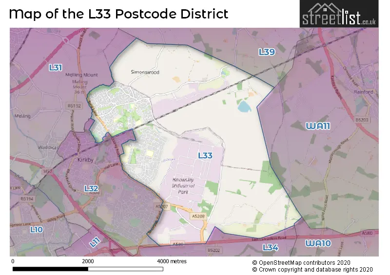
Currently, the L33 district has about 535 postcode units spread across 10 geographic postcode sectors.
Given that each sector allows for 400 unique postcode combinations, the district has a capacity of 4,000 postcodes. With 535 postcodes already in use, this leaves 3465 units available.
The largest settlement in the L33 postal code is LIVERPOOL followed by Knowsley Industrial Park, and Kirkby.
The L33 Postcode shares a border with L31 (LIVERPOOL, Maghull, Melling), L32 (LIVERPOOL, Kirkby) and L34 (PRESCOT, Knowsley, Eccleston Park).
The primary settlement in the L33 postcode district is Liverpool. It is located in Merseyside, which is a county in England. Other significant settlements in the district include Kirkby and Knowsley Industrial Park. The post town for the L33 postcode district is also Liverpool, which has the highest number of postcodes in the district.
For the district L33, we have data on 10 postcode sectors. Here's a breakdown: The sector L33 0, covers Liverpool in Merseyside. The sector L33 1, covers Liverpool and Kirkby in Merseyside. The sector L33 2, covers Kirkby and Liverpool in Merseyside. The sector L33 3, covers Liverpool in Merseyside. The sector L33 3, covers Liverpool in Lancashire. The sector L33 4, covers Liverpool and Kirkby in Merseyside. The sector L33 5, covers Liverpool in Merseyside. The sector L33 6, covers Liverpool in Merseyside. The sector L33 7, covers Knowsley Industrial Park and Liverpool in Merseyside. The sector L33 8, covers Liverpool in Merseyside. The sector L33 9, covers Liverpool in Merseyside.


Map of the L33 Postcode District
Explore the L33 postcode district by using our free interactive map.
When it comes to local government, postal geography often disregards political borders. However, for a breakdown in the L33 District: the district mostly encompasses the Knowsley District (B) (526 postcodes), and finally, the West Lancashire District (B) area (15 postcodes).
Recent House Sales in L33
| Date | Price | Address |
|---|---|---|
| 22/09/2023 | £140,000 | Westhead Avenue, Liverpool, L33 5XA |
| 01/09/2023 | £115,000 | Mintor Road, Liverpool, L33 5XQ |
| 31/08/2023 | £274,000 | Swinley Close, Kirkby, Liverpool, L33 2AH |
| 25/08/2023 | £116,500 | Changford Road, Liverpool, L33 9UD |
| 21/08/2023 | £240,000 | Jedburgh Drive, Liverpool, L33 1EQ |
| 18/08/2023 | £155,000 | Beattock Close, Liverpool, L33 1ER |
| 17/08/2023 | £145,000 | Melrose Road, Kirkby, Liverpool, L33 1ED |
| 11/08/2023 | £125,000 | Bramcote Road, Liverpool, L33 9UZ |
| 11/08/2023 | £305,000 | Chadwick Way, Kirkby, Liverpool, L33 4GB |
| 10/08/2023 | £113,000 | Riesling Drive, Kirkby, Liverpool, L33 1SH |
Weather Forecast for L33
Press Button to Show Forecast for Kirkby
| Time Period | Icon | Description | Temperature | Rain Probability | Wind |
|---|---|---|---|---|---|
| 03:00 to 06:00 | Partly cloudy (night) | 5.0°C (feels like 3.0°C) | 2.00% | ENE 7 mph | |
| 06:00 to 09:00 | Partly cloudy (day) | 5.0°C (feels like 3.0°C) | 2.00% | ENE 7 mph | |
| 09:00 to 12:00 | Cloudy | 8.0°C (feels like 6.0°C) | 5.00% | E 9 mph | |
| 12:00 to 15:00 | Cloudy | 10.0°C (feels like 8.0°C) | 47.00% | E 9 mph | |
| 15:00 to 18:00 | Cloudy | 10.0°C (feels like 8.0°C) | 46.00% | ENE 7 mph | |
| 18:00 to 21:00 | Cloudy | 9.0°C (feels like 7.0°C) | 13.00% | ENE 9 mph | |
| 21:00 to 00:00 | Cloudy | 8.0°C (feels like 6.0°C) | 6.00% | NE 7 mph |
Press Button to Show Forecast for Kirkby
| Time Period | Icon | Description | Temperature | Rain Probability | Wind |
|---|---|---|---|---|---|
| 00:00 to 03:00 | Partly cloudy (night) | 6.0°C (feels like 4.0°C) | 2.00% | NNE 7 mph | |
| 03:00 to 06:00 | Cloudy | 5.0°C (feels like 3.0°C) | 4.00% | NNE 9 mph | |
| 06:00 to 09:00 | Cloudy | 6.0°C (feels like 3.0°C) | 8.00% | N 9 mph | |
| 09:00 to 12:00 | Cloudy | 8.0°C (feels like 5.0°C) | 10.00% | NNW 9 mph | |
| 12:00 to 15:00 | Partly cloudy (day) | 9.0°C (feels like 7.0°C) | 8.00% | NW 11 mph | |
| 15:00 to 18:00 | Sunny day | 10.0°C (feels like 7.0°C) | 8.00% | WNW 13 mph | |
| 18:00 to 21:00 | Sunny day | 10.0°C (feels like 8.0°C) | 3.00% | W 11 mph | |
| 21:00 to 00:00 | Clear night | 9.0°C (feels like 6.0°C) | 2.00% | SW 11 mph |
Press Button to Show Forecast for Kirkby
| Time Period | Icon | Description | Temperature | Rain Probability | Wind |
|---|---|---|---|---|---|
| 00:00 to 03:00 | Clear night | 8.0°C (feels like 5.0°C) | 1.00% | SSW 9 mph | |
| 03:00 to 06:00 | Cloudy | 7.0°C (feels like 4.0°C) | 6.00% | S 9 mph | |
| 06:00 to 09:00 | Cloudy | 7.0°C (feels like 3.0°C) | 10.00% | SSE 11 mph | |
| 09:00 to 12:00 | Partly cloudy (day) | 10.0°C (feels like 7.0°C) | 2.00% | SSE 13 mph | |
| 12:00 to 15:00 | Cloudy | 13.0°C (feels like 10.0°C) | 8.00% | S 16 mph | |
| 15:00 to 18:00 | Overcast | 13.0°C (feels like 10.0°C) | 13.00% | S 16 mph | |
| 18:00 to 21:00 | Cloudy | 13.0°C (feels like 10.0°C) | 10.00% | SSE 16 mph | |
| 21:00 to 00:00 | Partly cloudy (night) | 11.0°C (feels like 9.0°C) | 3.00% | SSE 13 mph |
Press Button to Show Forecast for Kirkby
| Time Period | Icon | Description | Temperature | Rain Probability | Wind |
|---|---|---|---|---|---|
| 00:00 to 03:00 | Partly cloudy (night) | 10.0°C (feels like 7.0°C) | 4.00% | SE 13 mph | |
| 03:00 to 06:00 | Cloudy | 9.0°C (feels like 6.0°C) | 7.00% | SE 13 mph | |
| 06:00 to 09:00 | Cloudy | 9.0°C (feels like 6.0°C) | 6.00% | SE 13 mph | |
| 09:00 to 12:00 | Partly cloudy (day) | 12.0°C (feels like 9.0°C) | 4.00% | SE 13 mph | |
| 12:00 to 15:00 | Partly cloudy (day) | 15.0°C (feels like 11.0°C) | 5.00% | SE 16 mph | |
| 15:00 to 18:00 | Cloudy | 16.0°C (feels like 13.0°C) | 11.00% | SE 13 mph | |
| 18:00 to 21:00 | Partly cloudy (day) | 15.0°C (feels like 13.0°C) | 6.00% | SE 11 mph | |
| 21:00 to 00:00 | Cloudy | 13.0°C (feels like 11.0°C) | 7.00% | ESE 11 mph |
Where is the L33 Postcode District?
The postcode district L33 is located in Liverpool. It is approximately 178.9 miles away from the center of London. In relation to nearby towns, L33 is surrounded by Skelmersdale, Prescot, Bootle, Ormskirk, Newton-le-Willows, and Wallasey.
The district is within the post town of LIVERPOOL.
The sector has postcodes within the nation of England.
The L33 Postcode District is covers the following regions.
- East Merseyside - Merseyside - North West (England)
- Sefton - Merseyside - North West (England)
- Chorley and West Lancashire - Lancashire - North West (England)
Postcode Sectors within the L33 District
| Postcode Sector | Delivery Office |
|---|---|
| L33 0 | Kirkby Delivery Office |
| L33 1 | Kirkby Delivery Office |
| L33 2 | Kirkby Delivery Office |
| L33 3 | Kirkby Delivery Office |
| L33 4 | Kirkby Delivery Office |
| L33 5 | Kirkby Delivery Office |
| L33 6 | Kirkby Delivery Office |
| L33 7 | Kirkby Delivery Office |
| L33 8 | Kirkby Delivery Office |
| L33 9 | Kirkby Delivery Office |
| L | 3 | 3 | - | X | X | X |
| L | 3 | 3 | Space | Numeric | Letter | Letter |
Tourist Attractions within the Postcode Area
We found 1 visitor attractions within the L33 postcode area
| Acorn Farm |
|---|
| Farms |
| Farm / Rare Breeds / Farm Animals |
| View Acorn Farm on Google Maps |
Current Monthly Rental Prices
| # Bedrooms | Min Price | Max Price | Avg Price |
|---|---|---|---|
| 1 | £550 | £550 | £550 |
| 2 | £500 | £925 | £713 |
Current House Prices
| # Bedrooms | Min Price | Max Price | Avg Price |
|---|---|---|---|
| 1 | £18,000 | £18,000 | £18,000 |
| 2 | £10,000 | £190,000 | £114,840 |
| 3 | £99,950 | £595,000 | £192,011 |
| 4 | £125,000 | £400,000 | £254,279 |
| 5 | £165,000 | £165,000 | £165,000 |
| 6 | £595,000 | £595,000 | £595,000 |
Estate Agents who Operate in the L33 District
| Logo | Name | Brand Name | Address | Contact Number | Total Properties |
|---|---|---|---|---|---|
 | Kirkby | Greenbank Property Services | Unit 5 Melling Drive, Old Hall Estate Liverpool, L32 1TT | 0151 548 5488 | 10 |
 | Kirkby | Doran Kennedy | 14 Park brow drive, Kirkby, Liverpool, L32 6QP | 0151 453 3703 | 8 |
 | Maghull | Entwistle Green | 26 Central Square, Maghull, Liverpool, L31 0AE | 0151 453 9798 | 7 |
 | covering Liverpool | Purplebricks | Suite 7 First Floor Cranmore Drive Shirley Solihull B90 4RZ | 020 3907 2647 | 4 |
 | Leeds | New Home Agents | Unit 7, First Floor Hepton Court Leeds LS9 6PW | 0113 322 5766 | 2 |
| Type of Property | 2018 Average | 2018 Sales | 2017 Average | 2017 Sales | 2016 Average | 2016 Sales | 2015 Average | 2015 Sales |
|---|---|---|---|---|---|---|---|---|
| Detached | £176,168 | 75 | £171,384 | 64 | £171,010 | 39 | £141,912 | 28 |
| Semi-Detached | £123,973 | 106 | £115,840 | 129 | £106,834 | 76 | £95,340 | 69 |
| Terraced | £79,412 | 86 | £74,578 | 64 | £72,038 | 52 | £70,737 | 55 |
| Flats | £59,402 | 9 | £50,499 | 6 | £51,736 | 7 | £46,732 | 65 |