The L4 8 postcode sector is within the county of Merseyside.
Did you know? According to the 2021 Census, the L4 8 postcode sector is home to a bustling 2,913 residents!
Given that each sector allows for 400 unique postcode combinations. Letters C, I, K, M, O and V are not allowed in the last two letters of a postcode. With 57 postcodes already in use, this leaves 343 units available.
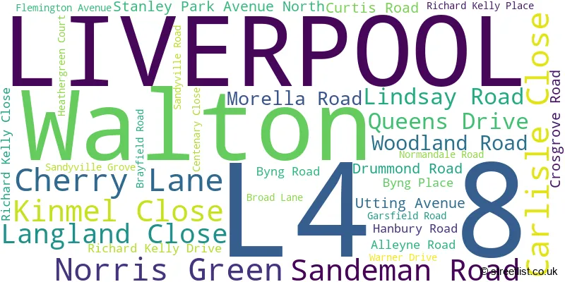
The largest settlement in the L4 8 postal code is LIVERPOOL followed by Walton, and Norris Green.
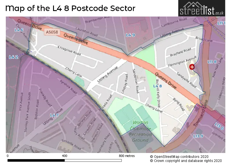
The L4 8 Postcode shares a border with L4 6 (LIVERPOOL, Walton), L4 7 (LIVERPOOL, Anfield), L4 9 (LIVERPOOL, Walton), L11 8 (LIVERPOOL, Norris Green, West Derby) and L13 9 (LIVERPOOL, Clubmoor).
The sector is within the post town of LIVERPOOL.
L4 8 is a postcode sector within the L4 postcode district which is within the L Liverpool postcode area.
The Royal Mail delivery office for the L4 8 postal sector is the Liverpool 4-5.
The area of the L4 8 postcode sector is 0.23 square miles which is 0.60 square kilometres or 147.19 square acres.

Map of the L4 8 Postcode Sector
Explore the L4 8 postcode sector by using our free interactive map.
| L | 4 | - | 8 | X | X |
| L | 4 | Space | 8 | Letter | Letter |
Official List of Streets
LIVERPOOL (26 Streets)
Norris Green (1 Streets)
Unofficial Streets or Alternative Spellings
LIVERPOOL
ABINGDON ROAD ATHELDENE ROAD CHERRY AVENUE DANEVILLE ROAD STANLEY PARK AVENUE SOUTHClubmoor
TOWNSEND AVENUE QUEENS DRIVE WALTONStoneycroft
QUEENS DRIVEWeather Forecast for L4 8
Press Button to Show Forecast for Liverpool F.C.
| Time Period | Icon | Description | Temperature | Rain Probability | Wind |
|---|---|---|---|---|---|
| 03:00 to 06:00 | Clear night | 4.0°C (feels like 2.0°C) | 2.00% | E 7 mph | |
| 06:00 to 09:00 | Sunny day | 4.0°C (feels like 1.0°C) | 1.00% | E 4 mph | |
| 09:00 to 12:00 | Partly cloudy (day) | 7.0°C (feels like 5.0°C) | 5.00% | E 4 mph | |
| 12:00 to 15:00 | Cloudy | 9.0°C (feels like 8.0°C) | 6.00% | NNE 4 mph | |
| 15:00 to 18:00 | Cloudy | 9.0°C (feels like 8.0°C) | 6.00% | N 7 mph | |
| 18:00 to 21:00 | Cloudy | 9.0°C (feels like 7.0°C) | 6.00% | NNE 7 mph | |
| 21:00 to 00:00 | Cloudy | 7.0°C (feels like 5.0°C) | 8.00% | NE 7 mph |
Press Button to Show Forecast for Liverpool F.C.
| Time Period | Icon | Description | Temperature | Rain Probability | Wind |
|---|---|---|---|---|---|
| 00:00 to 03:00 | Partly cloudy (night) | 5.0°C (feels like 3.0°C) | 6.00% | ESE 7 mph | |
| 03:00 to 06:00 | Partly cloudy (night) | 4.0°C (feels like 2.0°C) | 7.00% | ESE 7 mph | |
| 06:00 to 09:00 | Partly cloudy (day) | 4.0°C (feels like 2.0°C) | 5.00% | E 7 mph | |
| 09:00 to 12:00 | Cloudy | 8.0°C (feels like 6.0°C) | 8.00% | ESE 7 mph | |
| 12:00 to 15:00 | Overcast | 10.0°C (feels like 8.0°C) | 14.00% | E 7 mph | |
| 15:00 to 18:00 | Cloudy | 10.0°C (feels like 9.0°C) | 18.00% | NE 7 mph | |
| 18:00 to 21:00 | Cloudy | 10.0°C (feels like 8.0°C) | 15.00% | ENE 9 mph | |
| 21:00 to 00:00 | Partly cloudy (night) | 8.0°C (feels like 6.0°C) | 13.00% | ENE 9 mph |
Press Button to Show Forecast for Liverpool F.C.
| Time Period | Icon | Description | Temperature | Rain Probability | Wind |
|---|---|---|---|---|---|
| 00:00 to 03:00 | Cloudy | 6.0°C (feels like 4.0°C) | 17.00% | NE 9 mph | |
| 03:00 to 06:00 | Cloudy | 6.0°C (feels like 3.0°C) | 16.00% | NNE 11 mph | |
| 06:00 to 09:00 | Light rain | 7.0°C (feels like 3.0°C) | 47.00% | NNE 11 mph | |
| 09:00 to 12:00 | Cloudy | 8.0°C (feels like 5.0°C) | 20.00% | NNE 11 mph | |
| 12:00 to 15:00 | Light rain | 9.0°C (feels like 6.0°C) | 52.00% | NNE 11 mph | |
| 15:00 to 18:00 | Heavy rain | 10.0°C (feels like 7.0°C) | 72.00% | N 11 mph | |
| 18:00 to 21:00 | Partly cloudy (day) | 10.0°C (feels like 8.0°C) | 13.00% | WNW 11 mph | |
| 21:00 to 00:00 | Clear night | 9.0°C (feels like 7.0°C) | 11.00% | WNW 9 mph |
Schools and Places of Education Within the L4 8 Postcode Sector
St Matthew's Catholic Primary School
Voluntary aided school
Queens Drive, Liverpool, Merseyside, L4 8UA
Head: Mrs Claire Sime
Ofsted Rating: Outstanding
Inspection: 2010-04-27 (5113 days ago)
Website: Visit St Matthew's Catholic Primary School Website
Phone: 01512261871
Number of Pupils: 411
House Prices in the L4 8 Postcode Sector
| Type of Property | 2018 Average | 2018 Sales | 2017 Average | 2017 Sales | 2016 Average | 2016 Sales | 2015 Average | 2015 Sales |
|---|---|---|---|---|---|---|---|---|
| Detached | £0 | 0 | £0 | 0 | £160,000 | 1 | £105,875 | 2 |
| Semi-Detached | £105,073 | 13 | £101,706 | 17 | £101,000 | 10 | £92,080 | 5 |
| Terraced | £84,888 | 20 | £91,675 | 14 | £81,036 | 14 | £76,625 | 10 |
| Flats | £66,250 | 2 | £34,000 | 1 | £119,000 | 1 | £91,275 | 2 |
Important Postcodes L4 8 in the Postcode Sector
L4 8UA is the postcode for St Matthews Catholic Primary School, Queens Drive, Walton, and St. Matthews Primary School, Queens Drive
| The L4 8 Sector is within these Local Authorities |
|
|---|---|
| The L4 8 Sector is within these Counties |
|
| The L4 8 Sector is within these Water Company Areas |
|