The L4 9 postcode sector is within the county of Merseyside.
Did you know? According to the 2021 Census, the L4 9 postcode sector is home to a bustling 5,426 residents!
Given that each sector allows for 400 unique postcode combinations. Letters C, I, K, M, O and V are not allowed in the last two letters of a postcode. With 82 postcodes already in use, this leaves 318 units available.
The largest settlements in the L4 9 postal code are LIVERPOOL and Walton.
The L4 9 Postcode shares a border with L4 6 (LIVERPOOL, Walton), L4 8 (LIVERPOOL, Walton, Norris Green), L9 1 (LIVERPOOL, Walton), L9 6 (LIVERPOOL, Walton), L11 7 (LIVERPOOL, Norris Green) and L11 8 (LIVERPOOL, Norris Green, West Derby).
The sector is within the post town of LIVERPOOL.
L4 9 is a postcode sector within the L4 postcode district which is within the L Liverpool postcode area.
The Royal Mail delivery office for the L4 9 postal sector is the Liverpool 4-5.
The area of the L4 9 postcode sector is 0.43 square miles which is 1.12 square kilometres or 277.71 square acres.

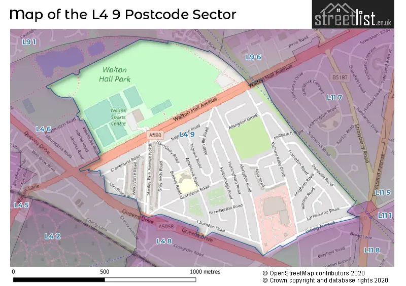
Map of the L4 9 Postcode Sector
Explore the L4 9 postcode sector by using our free interactive map.
| L | 4 | - | 9 | X | X |
| L | 4 | Space | 9 | Letter | Letter |
Official List of Streets
Walton (4 Streets)
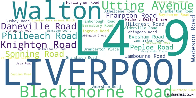
LIVERPOOL (35 Streets)
Unofficial Streets or Alternative Spellings
LIVERPOOL
HAGGERSTON ROAD WOOLHOPE ROAD BLACKTHORNE ROAD SAINT MATHEWS CLOSEStoneycroft
QUEENS DRIVEWeather Forecast for L4 9
Press Button to Show Forecast for Everton F.C.
| Time Period | Icon | Description | Temperature | Rain Probability | Wind |
|---|---|---|---|---|---|
| 18:00 to 21:00 | Light rain | 8.0°C (feels like 6.0°C) | 47.00% | NE 9 mph | |
| 21:00 to 00:00 | Cloudy | 7.0°C (feels like 5.0°C) | 6.00% | E 9 mph |
Press Button to Show Forecast for Everton F.C.
| Time Period | Icon | Description | Temperature | Rain Probability | Wind |
|---|---|---|---|---|---|
| 00:00 to 03:00 | Cloudy | 6.0°C (feels like 4.0°C) | 5.00% | E 7 mph | |
| 03:00 to 06:00 | Partly cloudy (night) | 5.0°C (feels like 3.0°C) | 2.00% | ENE 7 mph | |
| 06:00 to 09:00 | Partly cloudy (day) | 5.0°C (feels like 2.0°C) | 2.00% | ENE 7 mph | |
| 09:00 to 12:00 | Cloudy | 8.0°C (feels like 6.0°C) | 5.00% | E 9 mph | |
| 12:00 to 15:00 | Cloudy | 10.0°C (feels like 8.0°C) | 7.00% | E 9 mph | |
| 15:00 to 18:00 | Cloudy | 10.0°C (feels like 8.0°C) | 46.00% | ENE 9 mph | |
| 18:00 to 21:00 | Overcast | 9.0°C (feels like 7.0°C) | 12.00% | NE 9 mph | |
| 21:00 to 00:00 | Cloudy | 8.0°C (feels like 5.0°C) | 8.00% | NE 9 mph |
Press Button to Show Forecast for Everton F.C.
| Time Period | Icon | Description | Temperature | Rain Probability | Wind |
|---|---|---|---|---|---|
| 00:00 to 03:00 | Partly cloudy (night) | 6.0°C (feels like 4.0°C) | 2.00% | NE 7 mph | |
| 03:00 to 06:00 | Cloudy | 5.0°C (feels like 3.0°C) | 4.00% | NNE 9 mph | |
| 06:00 to 09:00 | Cloudy | 6.0°C (feels like 3.0°C) | 8.00% | N 9 mph | |
| 09:00 to 12:00 | Cloudy | 8.0°C (feels like 5.0°C) | 10.00% | NNW 11 mph | |
| 12:00 to 15:00 | Partly cloudy (day) | 9.0°C (feels like 6.0°C) | 8.00% | NW 11 mph | |
| 15:00 to 18:00 | Sunny day | 10.0°C (feels like 7.0°C) | 7.00% | WNW 13 mph | |
| 18:00 to 21:00 | Sunny day | 10.0°C (feels like 7.0°C) | 4.00% | W 11 mph | |
| 21:00 to 00:00 | Clear night | 9.0°C (feels like 6.0°C) | 2.00% | SW 11 mph |
Press Button to Show Forecast for Everton F.C.
| Time Period | Icon | Description | Temperature | Rain Probability | Wind |
|---|---|---|---|---|---|
| 00:00 to 03:00 | Clear night | 8.0°C (feels like 5.0°C) | 1.00% | SSW 9 mph | |
| 03:00 to 06:00 | Cloudy | 7.0°C (feels like 4.0°C) | 6.00% | S 11 mph | |
| 06:00 to 09:00 | Cloudy | 7.0°C (feels like 3.0°C) | 10.00% | SSE 11 mph | |
| 09:00 to 12:00 | Partly cloudy (day) | 10.0°C (feels like 7.0°C) | 2.00% | SSE 13 mph | |
| 12:00 to 15:00 | Cloudy | 13.0°C (feels like 10.0°C) | 8.00% | S 16 mph | |
| 15:00 to 18:00 | Overcast | 13.0°C (feels like 10.0°C) | 13.00% | S 16 mph | |
| 18:00 to 21:00 | Cloudy | 13.0°C (feels like 10.0°C) | 10.00% | SSE 16 mph | |
| 21:00 to 00:00 | Partly cloudy (night) | 11.0°C (feels like 8.0°C) | 3.00% | SSE 13 mph |
Press Button to Show Forecast for Everton F.C.
| Time Period | Icon | Description | Temperature | Rain Probability | Wind |
|---|---|---|---|---|---|
| 00:00 to 03:00 | Partly cloudy (night) | 10.0°C (feels like 7.0°C) | 4.00% | SE 13 mph | |
| 03:00 to 06:00 | Cloudy | 9.0°C (feels like 6.0°C) | 7.00% | SE 13 mph | |
| 06:00 to 09:00 | Cloudy | 9.0°C (feels like 6.0°C) | 6.00% | SE 13 mph | |
| 09:00 to 12:00 | Partly cloudy (day) | 12.0°C (feels like 9.0°C) | 4.00% | SE 13 mph | |
| 12:00 to 15:00 | Partly cloudy (day) | 14.0°C (feels like 11.0°C) | 5.00% | SE 16 mph | |
| 15:00 to 18:00 | Cloudy | 15.0°C (feels like 13.0°C) | 11.00% | SE 13 mph | |
| 18:00 to 21:00 | Partly cloudy (day) | 15.0°C (feels like 12.0°C) | 6.00% | SE 11 mph | |
| 21:00 to 00:00 | Cloudy | 13.0°C (feels like 11.0°C) | 7.00% | ESE 11 mph |
Schools and Places of Education Within the L4 9 Postcode Sector
Florence Melly Community Primary School
Community school
Bushey Road, Liverpool, Merseyside, L4 9UA
Head: Mr Aaron Leach
Ofsted Rating: Outstanding
Inspection: 2019-06-28 (1764 days ago)
Website: Visit Florence Melly Community Primary School Website
Phone: 01512261929
Number of Pupils: 438
House Prices in the L4 9 Postcode Sector
| Type of Property | 2018 Average | 2018 Sales | 2017 Average | 2017 Sales | 2016 Average | 2016 Sales | 2015 Average | 2015 Sales |
|---|---|---|---|---|---|---|---|---|
| Detached | £0 | 0 | £118,000 | 1 | £72,750 | 2 | £0 | 0 |
| Semi-Detached | £114,596 | 11 | £84,062 | 16 | £91,411 | 14 | £77,955 | 11 |
| Terraced | £80,885 | 13 | £77,833 | 9 | £82,813 | 11 | £68,917 | 12 |
| Flats | £69,000 | 2 | £46,375 | 2 | £47,750 | 2 | £0 | 0 |
Important Postcodes L4 9 in the Postcode Sector
L4 9UA is the postcode for FLORENCE MELLY PRIMARY SCHOOL, BUSHEY ROAD, LIVERPOOL, and Florence Melly Primary School, Bushey Road
L4 9XP is the postcode for Walton Sports Centre, Walton Hall Avenue
| The L4 9 Sector is within these Local Authorities |
|
|---|---|
| The L4 9 Sector is within these Counties |
|
| The L4 9 Sector is within these Water Company Areas |
|