The L6 9 postcode sector is within the county of Merseyside.
Did you know? According to the 2021 Census, the L6 9 postcode sector is home to a bustling 1,650 residents!
Given that each sector allows for 400 unique postcode combinations. Letters C, I, K, M, O and V are not allowed in the last two letters of a postcode. With 44 postcodes already in use, this leaves 356 units available.
The largest settlements in the L6 9 postal code are LIVERPOOL and Kensington.
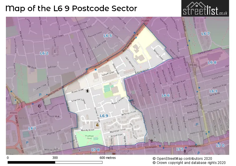
The L6 9 Postcode shares a border with L6 5 (LIVERPOOL, Anfield, Everton), L6 6 (LIVERPOOL, Kensington, Fairfield), L6 1 (LIVERPOOL, Erskine Industrial Estate), L6 2 (LIVERPOOL, Everton), L6 3 (LIVERPOOL, Fairfield), L7 2 (LIVERPOOL, Edge Hill) and L7 8 (LIVERPOOL, Kensington, Edge Hill).
The sector is within the post town of LIVERPOOL.
L6 9 is a postcode sector within the L6 postcode district which is within the L Liverpool postcode area.
The Royal Mail delivery office for the L6 9 postal sector is the Liverpool 6-7.
The area of the L6 9 postcode sector is 0.10 square miles which is 0.27 square kilometres or 66.68 square acres.

Map of the L6 9 Postcode Sector
Explore the L6 9 postcode sector by using our free interactive map.
| L | 6 | - | 9 | X | X |
| L | 6 | Space | 9 | Letter | Letter |
Official List of Streets
LIVERPOOL (29 Streets)
Kensington (1 Streets)
Unofficial Streets or Alternative Spellings
LIVERPOOL
COLERIDGE STREET HORNE STREET HUTCHINSON STREET KILSHAW STREET MARVIN STREET SUTCLIFFE STREET UPPER BAKER STREET CAMBRIA STREET NORTH COTTENHAM STREET DENMAN STREET GOLDSMITH STREET MISSION WALK SAINT MICHAELS GROVE TUDOR STREET NORTH TUDOR STREET SOUTH WIGHTMAN STREETEverton
BOUNDARY LANEWeather Forecast for L6 9
Press Button to Show Forecast for Edge Hill
| Time Period | Icon | Description | Temperature | Rain Probability | Wind |
|---|---|---|---|---|---|
| 09:00 to 12:00 | Cloudy | 6.0°C (feels like 4.0°C) | 4.00% | E 7 mph | |
| 12:00 to 15:00 | Overcast | 9.0°C (feels like 8.0°C) | 11.00% | E 4 mph | |
| 15:00 to 18:00 | Cloudy | 10.0°C (feels like 9.0°C) | 8.00% | NNE 4 mph | |
| 18:00 to 21:00 | Cloudy | 9.0°C (feels like 7.0°C) | 10.00% | NE 7 mph | |
| 21:00 to 00:00 | Cloudy | 7.0°C (feels like 5.0°C) | 8.00% | E 9 mph |
Press Button to Show Forecast for Edge Hill
| Time Period | Icon | Description | Temperature | Rain Probability | Wind |
|---|---|---|---|---|---|
| 00:00 to 03:00 | Cloudy | 6.0°C (feels like 4.0°C) | 6.00% | E 7 mph | |
| 03:00 to 06:00 | Cloudy | 6.0°C (feels like 3.0°C) | 5.00% | E 7 mph | |
| 06:00 to 09:00 | Partly cloudy (day) | 5.0°C (feels like 2.0°C) | 2.00% | E 9 mph | |
| 09:00 to 12:00 | Cloudy | 8.0°C (feels like 6.0°C) | 5.00% | E 9 mph | |
| 12:00 to 15:00 | Overcast | 10.0°C (feels like 8.0°C) | 16.00% | E 9 mph | |
| 15:00 to 18:00 | Overcast | 10.0°C (feels like 8.0°C) | 16.00% | ENE 9 mph | |
| 18:00 to 21:00 | Overcast | 9.0°C (feels like 7.0°C) | 46.00% | NE 9 mph | |
| 21:00 to 00:00 | Cloudy | 8.0°C (feels like 6.0°C) | 6.00% | NE 9 mph |
Press Button to Show Forecast for Edge Hill
| Time Period | Icon | Description | Temperature | Rain Probability | Wind |
|---|---|---|---|---|---|
| 00:00 to 03:00 | Cloudy | 7.0°C (feels like 4.0°C) | 4.00% | NE 7 mph | |
| 03:00 to 06:00 | Cloudy | 6.0°C (feels like 3.0°C) | 4.00% | NNE 9 mph | |
| 06:00 to 09:00 | Cloudy | 6.0°C (feels like 3.0°C) | 8.00% | N 9 mph | |
| 09:00 to 12:00 | Cloudy | 8.0°C (feels like 5.0°C) | 10.00% | NNW 9 mph | |
| 12:00 to 15:00 | Cloudy | 9.0°C (feels like 7.0°C) | 12.00% | NW 11 mph | |
| 15:00 to 18:00 | Sunny day | 10.0°C (feels like 7.0°C) | 9.00% | WNW 13 mph | |
| 18:00 to 21:00 | Sunny day | 10.0°C (feels like 8.0°C) | 3.00% | W 11 mph | |
| 21:00 to 00:00 | Clear night | 9.0°C (feels like 6.0°C) | 2.00% | SW 11 mph |
Press Button to Show Forecast for Edge Hill
| Time Period | Icon | Description | Temperature | Rain Probability | Wind |
|---|---|---|---|---|---|
| 00:00 to 03:00 | Clear night | 8.0°C (feels like 5.0°C) | 1.00% | SSW 11 mph | |
| 03:00 to 06:00 | Cloudy | 7.0°C (feels like 4.0°C) | 5.00% | S 11 mph | |
| 06:00 to 09:00 | Cloudy | 7.0°C (feels like 3.0°C) | 7.00% | SSE 11 mph | |
| 09:00 to 12:00 | Partly cloudy (day) | 10.0°C (feels like 7.0°C) | 2.00% | SSE 13 mph | |
| 12:00 to 15:00 | Overcast | 13.0°C (feels like 10.0°C) | 10.00% | S 16 mph | |
| 15:00 to 18:00 | Cloudy | 13.0°C (feels like 10.0°C) | 9.00% | S 16 mph | |
| 18:00 to 21:00 | Cloudy | 13.0°C (feels like 10.0°C) | 8.00% | SSE 16 mph | |
| 21:00 to 00:00 | Partly cloudy (night) | 11.0°C (feels like 8.0°C) | 3.00% | SSE 13 mph |
Press Button to Show Forecast for Edge Hill
| Time Period | Icon | Description | Temperature | Rain Probability | Wind |
|---|---|---|---|---|---|
| 00:00 to 03:00 | Partly cloudy (night) | 10.0°C (feels like 7.0°C) | 4.00% | SE 13 mph | |
| 03:00 to 06:00 | Cloudy | 9.0°C (feels like 6.0°C) | 6.00% | SE 13 mph | |
| 06:00 to 09:00 | Cloudy | 9.0°C (feels like 6.0°C) | 6.00% | SE 13 mph | |
| 09:00 to 12:00 | Cloudy | 12.0°C (feels like 9.0°C) | 7.00% | SE 13 mph | |
| 12:00 to 15:00 | Partly cloudy (day) | 14.0°C (feels like 11.0°C) | 5.00% | SE 16 mph | |
| 15:00 to 18:00 | Cloudy | 16.0°C (feels like 13.0°C) | 14.00% | SE 13 mph | |
| 18:00 to 21:00 | Partly cloudy (day) | 15.0°C (feels like 13.0°C) | 6.00% | SE 11 mph | |
| 21:00 to 00:00 | Cloudy | 13.0°C (feels like 11.0°C) | 8.00% | E 9 mph |
Schools and Places of Education Within the L6 9 Postcode Sector
St Michael's Catholic Primary School
Voluntary aided school
Guion Street, Liverpool, Merseyside, L6 9DU
Head: Mrs Alyson Rigby
Ofsted Rating: Requires improvement
Inspection: 2020-02-12 (1535 days ago)
Website: Visit St Michael's Catholic Primary School Website
Phone: 01512638460
Number of Pupils: 442
House Prices in the L6 9 Postcode Sector
| Type of Property | 2018 Average | 2018 Sales | 2017 Average | 2017 Sales | 2016 Average | 2016 Sales | 2015 Average | 2015 Sales |
|---|---|---|---|---|---|---|---|---|
| Detached | £0 | 0 | £0 | 0 | £0 | 0 | £0 | 0 |
| Semi-Detached | £132,250 | 4 | £105,500 | 2 | £104,625 | 4 | £56,000 | 1 |
| Terraced | £121,409 | 11 | £92,814 | 11 | £76,345 | 10 | £80,266 | 10 |
| Flats | £33,500 | 2 | £28,500 | 1 | £58,883 | 15 | £30,000 | 1 |
Important Postcodes L6 9 in the Postcode Sector
L6 9DU is the postcode for INFANTS BUILDING, St. Michaels Primary School, Guion Street, and JUNIOR'S BUILDING, St. Michaels Primary School, Guion Street
L6 9EU is the postcode for New Park Primary, 100 Boaler Street, and New Park School Butler Wing, Butler Street
| The L6 9 Sector is within these Local Authorities |
|
|---|---|
| The L6 9 Sector is within these Counties |
|
| The L6 9 Sector is within these Water Company Areas |
|