The L6 postcode district is a postal district located in the L Liverpool postcode area with a population of 24,757 residents according to the 2021 England and Wales Census.
The area of the L6 postcode district is 1.41 square miles which is 3.64 square kilometres or 900.25 acres.
Currently, the L6 district has about 489 postcode units spread across 12 geographic postcode sectors.
Given that each sector allows for 400 unique postcode combinations, the district has a capacity of 4,800 postcodes. With 489 postcodes already in use, this leaves 4311 units available.
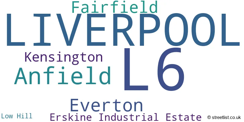
The largest settlement in the L6 postal code is LIVERPOOL followed by Anfield, and Fairfield.
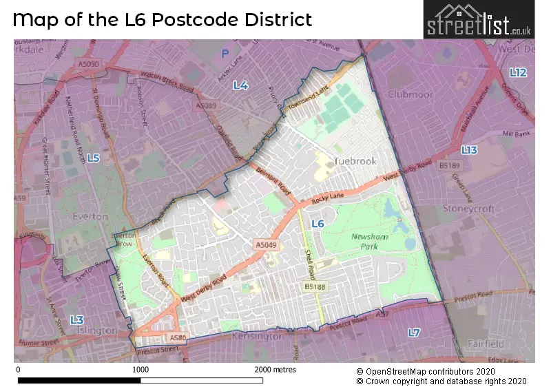
The L6 Postcode shares a border with L4 (LIVERPOOL, Walton, Anfield), L5 (LIVERPOOL, Kirkdale, Everton) and L7 (LIVERPOOL, Fairfield, Kensington).
In the L6 postcode district, the primary settlement is Liverpool, located in Merseyside, England. Other significant settlements include Anfield, Everton, Fairfield, and Kensington.
For the district L6, we have data on 10 postcode sectors. Here's a breakdown: The sector L6 0, covers Liverpool and Anfield in Merseyside. The sector L6 1, covers Liverpool in Merseyside. The sector L6 2, covers Liverpool and Everton in Merseyside. The sector L6 3, covers Liverpool in Merseyside. The sector L6 4, covers Liverpool and Anfield in Merseyside. The sector L6 5, covers Liverpool in Merseyside. The sector L6 6, covers Liverpool in Merseyside. The sector L6 7, covers Liverpool in Merseyside. The sector L6 8, covers Liverpool and Fairfield in Merseyside. The sector L6 9, covers Liverpool in Merseyside.

Map of the L6 Postcode District
Explore the L6 postcode district by using our free interactive map.
When it comes to local government, postal geography often disregards political borders. However, for a breakdown in the L6 District: the district mostly encompasses the Liverpool District (B) area with a total of 502 postcodes.
Recent House Sales in L6
| Date | Price | Address |
|---|---|---|
| 20/10/2023 | £72,000 | Rector Road, Liverpool, L6 0BY |
| 12/10/2023 | £50,000 | Simms Road, Liverpool, L6 4EA |
| 11/10/2023 | £185,000 | Epworth Street, Liverpool, L6 1LS |
| 05/10/2023 | £111,000 | Hannan Road, Liverpool, L6 6DB |
| 04/10/2023 | £75,000 | Berwick Street, Liverpool, L6 9DZ |
| 02/10/2023 | £105,000 | Scorton Street, Liverpool, L6 4AT |
| 29/09/2023 | £72,500 | Dorset Road, Anfield, Liverpool, L6 4DX |
| 25/09/2023 | £108,500 | Whitland Road, Liverpool, L6 8NR |
| 22/09/2023 | £85,000 | Suburban Road, Liverpool, L6 0BP |
| 31/08/2023 | £140,000 | Molyneux Road, Kensington, Liverpool, L6 6AL |
Weather Forecast for L6
Press Button to Show Forecast for Liverpool F.C.
| Time Period | Icon | Description | Temperature | Rain Probability | Wind |
|---|---|---|---|---|---|
| 09:00 to 12:00 | Cloudy | 8.0°C (feels like 5.0°C) | 5.00% | E 9 mph | |
| 12:00 to 15:00 | Overcast | 10.0°C (feels like 7.0°C) | 10.00% | ENE 9 mph | |
| 15:00 to 18:00 | Overcast | 10.0°C (feels like 8.0°C) | 46.00% | ENE 7 mph | |
| 18:00 to 21:00 | Overcast | 9.0°C (feels like 7.0°C) | 12.00% | NE 9 mph | |
| 21:00 to 00:00 | Cloudy | 8.0°C (feels like 6.0°C) | 8.00% | NE 9 mph |
Press Button to Show Forecast for Liverpool F.C.
| Time Period | Icon | Description | Temperature | Rain Probability | Wind |
|---|---|---|---|---|---|
| 00:00 to 03:00 | Cloudy | 7.0°C (feels like 4.0°C) | 4.00% | NE 7 mph | |
| 03:00 to 06:00 | Cloudy | 6.0°C (feels like 3.0°C) | 4.00% | NNE 9 mph | |
| 06:00 to 09:00 | Cloudy | 6.0°C (feels like 3.0°C) | 8.00% | N 9 mph | |
| 09:00 to 12:00 | Cloudy | 8.0°C (feels like 5.0°C) | 11.00% | NNW 11 mph | |
| 12:00 to 15:00 | Partly cloudy (day) | 9.0°C (feels like 6.0°C) | 9.00% | NW 13 mph | |
| 15:00 to 18:00 | Sunny day | 10.0°C (feels like 7.0°C) | 9.00% | WNW 13 mph | |
| 18:00 to 21:00 | Sunny day | 10.0°C (feels like 7.0°C) | 3.00% | W 11 mph | |
| 21:00 to 00:00 | Clear night | 9.0°C (feels like 6.0°C) | 2.00% | SW 11 mph |
Press Button to Show Forecast for Liverpool F.C.
| Time Period | Icon | Description | Temperature | Rain Probability | Wind |
|---|---|---|---|---|---|
| 00:00 to 03:00 | Partly cloudy (night) | 8.0°C (feels like 5.0°C) | 1.00% | SSW 9 mph | |
| 03:00 to 06:00 | Cloudy | 7.0°C (feels like 4.0°C) | 4.00% | S 11 mph | |
| 06:00 to 09:00 | Partly cloudy (day) | 7.0°C (feels like 3.0°C) | 4.00% | SSE 11 mph | |
| 09:00 to 12:00 | Partly cloudy (day) | 10.0°C (feels like 7.0°C) | 2.00% | SSE 13 mph | |
| 12:00 to 15:00 | Cloudy | 13.0°C (feels like 9.0°C) | 7.00% | S 16 mph | |
| 15:00 to 18:00 | Cloudy | 13.0°C (feels like 10.0°C) | 9.00% | S 16 mph | |
| 18:00 to 21:00 | Cloudy | 13.0°C (feels like 10.0°C) | 8.00% | SSE 16 mph | |
| 21:00 to 00:00 | Partly cloudy (night) | 11.0°C (feels like 8.0°C) | 3.00% | SSE 13 mph |
Press Button to Show Forecast for Liverpool F.C.
| Time Period | Icon | Description | Temperature | Rain Probability | Wind |
|---|---|---|---|---|---|
| 00:00 to 03:00 | Partly cloudy (night) | 10.0°C (feels like 7.0°C) | 4.00% | SE 13 mph | |
| 03:00 to 06:00 | Cloudy | 9.0°C (feels like 6.0°C) | 6.00% | SE 13 mph | |
| 06:00 to 09:00 | Partly cloudy (day) | 9.0°C (feels like 6.0°C) | 3.00% | SE 13 mph | |
| 09:00 to 12:00 | Partly cloudy (day) | 12.0°C (feels like 9.0°C) | 4.00% | SE 13 mph | |
| 12:00 to 15:00 | Partly cloudy (day) | 14.0°C (feels like 11.0°C) | 5.00% | SE 16 mph | |
| 15:00 to 18:00 | Cloudy | 15.0°C (feels like 12.0°C) | 14.00% | SE 13 mph | |
| 18:00 to 21:00 | Partly cloudy (day) | 15.0°C (feels like 13.0°C) | 6.00% | SE 11 mph | |
| 21:00 to 00:00 | Cloudy | 13.0°C (feels like 11.0°C) | 8.00% | E 9 mph |
Where is the L6 Postcode District?
The postcode district L6 is located in the town of Liverpool. It is nearby several other towns such as Bootle (3.58 miles to the North West), Wallasey (4.16 miles to the West), Birkenhead (4.97 miles to the South West), and Prescot (6.43 miles to the East). It is also approximately 177.92 miles away from the center of London.
The district is within the post town of LIVERPOOL.
The sector has postcodes within the nation of England.
The L6 Postcode District is in the Liverpool region of Merseyside within the North West (England).
Postcode Sectors within the L6 District
| Postcode Sector | Delivery Office |
|---|---|
| L6 0 | Liverpool 6-7 |
| L6 1 | Liverpool 6-7 |
| L6 2 | Liverpool 6-7 |
| L6 3 | Liverpool 6-7 |
| L6 4 | Liverpool 6-7 |
| L6 5 | Liverpool 6-7 |
| L6 6 | Liverpool 6-7 |
| L6 7 | Liverpool 6-7 |
| L6 8 | Liverpool 6-7 |
| L6 9 | Liverpool 6-7 |
| L | 6 | - | X | X | X |
| L | 6 | Space | Numeric | Letter | Letter |
Current Monthly Rental Prices
| # Bedrooms | Min Price | Max Price | Avg Price |
|---|---|---|---|
| £375 | £910 | £749 | |
| 1 | £325 | £845 | £567 |
| 2 | £390 | £895 | £625 |
| 3 | £390 | £1,495 | £853 |
| 4 | £394 | £2,000 | £902 |
| 5 | £347 | £2,383 | £928 |
| 6 | £325 | £2,730 | £759 |
| 7 | £386 | £4,000 | £1,925 |
| 8 | £3,987 | £3,987 | £3,987 |
| 23 | £7,700 | £7,700 | £7,700 |
Current House Prices
| # Bedrooms | Min Price | Max Price | Avg Price |
|---|---|---|---|
| £12,000 | £124,950 | £78,958 | |
| 1 | £45,000 | £229,950 | £137,689 |
| 2 | £45,000 | £349,995 | £177,232 |
| 3 | £85,000 | £249,950 | £142,730 |
| 4 | £159,000 | £290,000 | £214,600 |
| 5 | £140,000 | £375,000 | £254,500 |
| 6 | £165,000 | £400,000 | £287,500 |
| 7 | £247,000 | £300,000 | £273,500 |
| 8 | £280,000 | £280,000 | £280,000 |
| 12 | £550,000 | £550,000 | £550,000 |
| 16 | £395,000 | £395,000 | £395,000 |
Estate Agents who Operate in the L6 District
| Logo | Name | Brand Name | Address | Contact Number | Total Properties |
|---|---|---|---|---|---|
 | Element The Quarter | Legacie Management & Lettings Ltd | Walker Street Low Hill Liverpool L6 1EJ | 0151 453 0002 | 76 |
 | Liverpool | RW Invest | Unit 101, Tea Factory, 82 Wood Street, Liverpool, L1 4DQ | 0151 453 4672 | 48 |
 | New Homes | Nexus Residential | The Tea Factory, 82 Wood Street, Liverpool, L1 4DQ | 020 3907 2755 | 32 |
 | London | OpenRent | 39 Great Windmill Street London W1D 7LX | 020 3322 3265 | 28 |
 | Liverpool | Rooms4u | 467a Smithdown Road, Wavertree, Liverpool, L15 5AE | 0151 453 8343 | 21 |
| Type of Property | 2018 Average | 2018 Sales | 2017 Average | 2017 Sales | 2016 Average | 2016 Sales | 2015 Average | 2015 Sales |
|---|---|---|---|---|---|---|---|---|
| Detached | £262,857 | 7 | £162,778 | 9 | £171,477 | 11 | £126,333 | 3 |
| Semi-Detached | £130,939 | 37 | £129,939 | 32 | £121,581 | 47 | £90,931 | 34 |
| Terraced | £76,733 | 338 | £68,378 | 284 | £61,780 | 253 | £64,970 | 231 |
| Flats | £83,254 | 38 | £84,713 | 42 | £78,587 | 51 | £70,730 | 38 |