The L9 3 postcode sector is within the county of Merseyside.
Did you know? According to the 2021 Census, the L9 3 postcode sector is home to a bustling 3,105 residents!
Given that each sector allows for 400 unique postcode combinations. Letters C, I, K, M, O and V are not allowed in the last two letters of a postcode. With 46 postcodes already in use, this leaves 354 units available.
The largest settlements in the L9 3 postal code are LIVERPOOL and Walton.
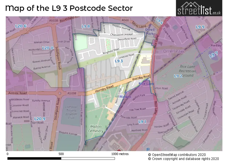
The L9 3 Postcode shares a border with L9 2 (LIVERPOOL, Walton), L9 1 (LIVERPOOL, Walton), L9 8 (LIVERPOOL, Orrell Park, Walton), L20 0 (BOOTLE) and L20 9 (BOOTLE).
The sector is within the post town of LIVERPOOL.
L9 3 is a postcode sector within the L9 postcode district which is within the L Liverpool postcode area.
The Royal Mail delivery office for the L9 3 postal sector is the Walton (l) Delivery Office.
The area of the L9 3 postcode sector is 0.19 square miles which is 0.50 square kilometres or 124.76 square acres.

Map of the L9 3 Postcode Sector
Explore the L9 3 postcode sector by using our free interactive map.
| L | 9 | - | 3 | X | X |
| L | 9 | Space | 3 | Letter | Letter |
Official List of Streets
LIVERPOOL (26 Streets)
Walton (3 Streets)
Unofficial Streets or Alternative Spellings
LIVERPOOL
DOVE ROAD GONDOVER AVENUE RAWCLIFFE ROAD WALTON PARKWalton
BROOK ROAD SEFTON ROAD STOKER WAY WHITEFIELD ROADBOOTLE
AINTREE ROADWeather Forecast for L9 3
Press Button to Show Forecast for Litherland
| Time Period | Icon | Description | Temperature | Rain Probability | Wind |
|---|---|---|---|---|---|
| 00:00 to 03:00 | Partly cloudy (night) | 6.0°C (feels like 4.0°C) | 2.00% | E 7 mph | |
| 03:00 to 06:00 | Clear night | 4.0°C (feels like 2.0°C) | 2.00% | E 7 mph | |
| 06:00 to 09:00 | Sunny day | 4.0°C (feels like 2.0°C) | 2.00% | E 7 mph | |
| 09:00 to 12:00 | Partly cloudy (day) | 7.0°C (feels like 5.0°C) | 5.00% | ESE 4 mph | |
| 12:00 to 15:00 | Cloudy | 9.0°C (feels like 8.0°C) | 6.00% | N 4 mph | |
| 15:00 to 18:00 | Cloudy | 9.0°C (feels like 8.0°C) | 6.00% | N 7 mph | |
| 18:00 to 21:00 | Cloudy | 9.0°C (feels like 7.0°C) | 6.00% | NNE 7 mph | |
| 21:00 to 00:00 | Cloudy | 7.0°C (feels like 5.0°C) | 7.00% | NE 9 mph |
Press Button to Show Forecast for Litherland
| Time Period | Icon | Description | Temperature | Rain Probability | Wind |
|---|---|---|---|---|---|
| 00:00 to 03:00 | Partly cloudy (night) | 6.0°C (feels like 3.0°C) | 4.00% | ESE 9 mph | |
| 03:00 to 06:00 | Partly cloudy (night) | 4.0°C (feels like 2.0°C) | 6.00% | ESE 7 mph | |
| 06:00 to 09:00 | Partly cloudy (day) | 5.0°C (feels like 2.0°C) | 4.00% | E 7 mph | |
| 09:00 to 12:00 | Cloudy | 8.0°C (feels like 6.0°C) | 8.00% | ESE 7 mph | |
| 12:00 to 15:00 | Overcast | 10.0°C (feels like 9.0°C) | 12.00% | E 7 mph | |
| 15:00 to 18:00 | Overcast | 10.0°C (feels like 9.0°C) | 18.00% | NE 7 mph | |
| 18:00 to 21:00 | Cloudy | 10.0°C (feels like 8.0°C) | 14.00% | ENE 9 mph | |
| 21:00 to 00:00 | Cloudy | 8.0°C (feels like 6.0°C) | 13.00% | ENE 9 mph |
Press Button to Show Forecast for Litherland
| Time Period | Icon | Description | Temperature | Rain Probability | Wind |
|---|---|---|---|---|---|
| 00:00 to 03:00 | Light rain | 7.0°C (feels like 4.0°C) | 45.00% | NE 9 mph | |
| 03:00 to 06:00 | Cloudy | 6.0°C (feels like 3.0°C) | 15.00% | NNE 11 mph | |
| 06:00 to 09:00 | Light rain | 7.0°C (feels like 4.0°C) | 48.00% | NNE 11 mph | |
| 09:00 to 12:00 | Cloudy | 8.0°C (feels like 5.0°C) | 20.00% | NNE 11 mph | |
| 12:00 to 15:00 | Light rain | 9.0°C (feels like 6.0°C) | 50.00% | N 11 mph | |
| 15:00 to 18:00 | Heavy rain | 10.0°C (feels like 7.0°C) | 70.00% | NNW 11 mph | |
| 18:00 to 21:00 | Partly cloudy (day) | 10.0°C (feels like 7.0°C) | 14.00% | WNW 13 mph | |
| 21:00 to 00:00 | Partly cloudy (night) | 9.0°C (feels like 7.0°C) | 9.00% | WNW 11 mph |
Schools and Places of Education Within the L9 3 Postcode Sector
Rice Lane Primary School and Nursery
Community school
Brockenhurst Road, Liverpool, , L9 3BU
Head: Mrs Lesley Roach
Ofsted Rating: Good
Inspection: 2023-10-11 (198 days ago)
Website: Visit Rice Lane Primary School and Nursery Website
Phone: 01515259776
Number of Pupils: 646
House Prices in the L9 3 Postcode Sector
| Type of Property | 2018 Average | 2018 Sales | 2017 Average | 2017 Sales | 2016 Average | 2016 Sales | 2015 Average | 2015 Sales |
|---|---|---|---|---|---|---|---|---|
| Detached | £177,125 | 4 | £182,500 | 2 | £173,500 | 2 | £150,650 | 3 |
| Semi-Detached | £131,709 | 11 | £94,167 | 6 | £120,424 | 10 | £99,727 | 11 |
| Terraced | £109,650 | 29 | £104,147 | 19 | £103,760 | 25 | £98,855 | 19 |
| Flats | £56,000 | 1 | £0 | 0 | £70,500 | 2 | £95,000 | 1 |
Important Postcodes L9 3 in the Postcode Sector
L9 3BU is the postcode for Rice Lane County Junior School, Brockenhurst Road
L9 3DF is the postcode for H M Prison, 68 Hornby Road, and VISITS CENTRE, H M Prison, 68 Hornby Road
| The L9 3 Sector is within these Local Authorities |
|
|---|---|
| The L9 3 Sector is within these Counties |
|
| The L9 3 Sector is within these Water Company Areas |
|