The LE3 8 postcode sector is within the county of Leicestershire.
Did you know? According to the 2021 Census, the LE3 8 postcode sector is home to a bustling 11,439 residents!
Given that each sector allows for 400 unique postcode combinations. Letters C, I, K, M, O and V are not allowed in the last two letters of a postcode. With 246 postcodes already in use, this leaves 154 units available.
The LE3 8 postal code covers the settlement of Glenfield.
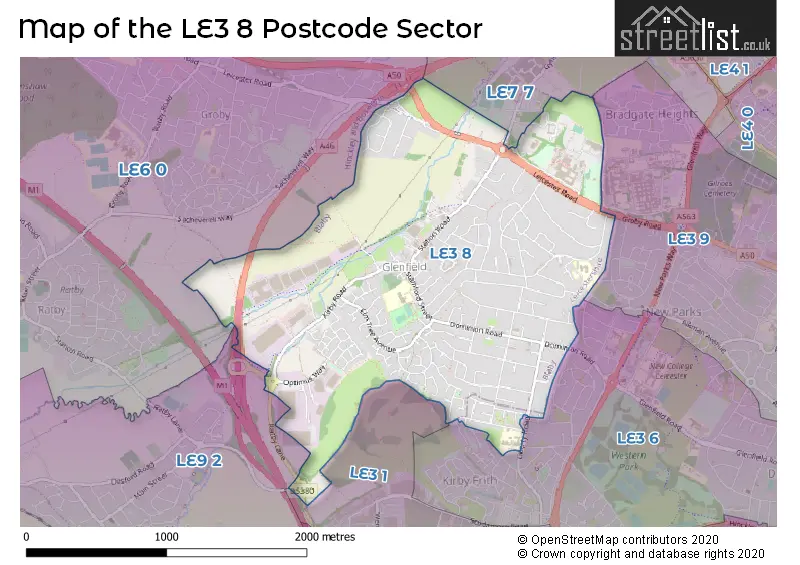
The LE3 8 Postcode shares a border with LE3 1 (LEICESTER), LE3 6 (LEICESTER), LE3 9 (LEICESTER), LE6 0 (Groby, Ratby, Newtown Linford), LE7 7 (Anstey, Rothley, Cropston) and LE9 2 (Kirby Muxloe).
The sector is within the post town of LEICESTER.
LE3 8 is a postcode sector within the LE3 postcode district which is within the LE Leicester postcode area.
The Royal Mail delivery office for the LE3 8 postal sector is the Leicester West Delivery Office.
The area of the LE3 8 postcode sector is 1.90 square miles which is 4.93 square kilometres or 1,217.20 square acres.
The LE3 8 postcode sector is crossed by the M1 motorway.
The LE3 8 postcode sector is crossed by the A46 Major A road.

Map of the LE3 8 Postcode Sector
Explore the LE3 8 postcode sector by using our free interactive map.
| L | E | 3 | - | 8 | X | X |
| L | E | 3 | Space | 8 | Letter | Letter |
Official List of Streets
Glenfield (150 Streets)
Unofficial Streets or Alternative Spellings
LEICESTER
BURSDON CLOSE CUFFLING DRIVE GROBY ROAD MULBERRY AVENUE ORMEN GREEN YEW TREE DRIVE ASHLEIGH COURT BARROW LANE BARROWS LANE CHAMPIONSHIP WAY ELLIS ROAD LEICESTER & SWANNINGTON MILL LANE OAKFIELD COURT ROMAN WAY SACHEVEREL ROAD SANDOWN COURT SPRING FIELD CLOSEKirby Muxloe
RATBY LANEAnstey
GYNSILL LANEGroby
LEICESTER ROADWeather Forecast for LE3 8
Press Button to Show Forecast for Glenfield
| Time Period | Icon | Description | Temperature | Rain Probability | Wind |
|---|---|---|---|---|---|
| 06:00 to 09:00 | Partly cloudy (day) | 2.0°C (feels like 0.0°C) | 1.00% | NE 4 mph | |
| 09:00 to 12:00 | Partly cloudy (day) | 7.0°C (feels like 4.0°C) | 1.00% | ENE 7 mph | |
| 12:00 to 15:00 | Cloudy | 9.0°C (feels like 8.0°C) | 8.00% | ENE 4 mph | |
| 15:00 to 18:00 | Cloudy | 10.0°C (feels like 9.0°C) | 8.00% | ENE 4 mph | |
| 18:00 to 21:00 | Cloudy | 8.0°C (feels like 6.0°C) | 9.00% | ENE 7 mph | |
| 21:00 to 00:00 | Cloudy | 5.0°C (feels like 3.0°C) | 9.00% | ENE 7 mph |
Press Button to Show Forecast for Glenfield
| Time Period | Icon | Description | Temperature | Rain Probability | Wind |
|---|---|---|---|---|---|
| 00:00 to 03:00 | Partly cloudy (night) | 4.0°C (feels like 2.0°C) | 6.00% | ENE 4 mph | |
| 03:00 to 06:00 | Cloudy | 3.0°C (feels like 1.0°C) | 11.00% | NE 4 mph | |
| 06:00 to 09:00 | Cloudy | 4.0°C (feels like 1.0°C) | 12.00% | NE 7 mph | |
| 09:00 to 12:00 | Cloudy | 8.0°C (feels like 5.0°C) | 14.00% | ENE 9 mph | |
| 12:00 to 15:00 | Overcast | 10.0°C (feels like 7.0°C) | 23.00% | ENE 9 mph | |
| 15:00 to 18:00 | Overcast | 10.0°C (feels like 8.0°C) | 22.00% | ENE 11 mph | |
| 18:00 to 21:00 | Cloudy | 9.0°C (feels like 7.0°C) | 17.00% | ENE 11 mph | |
| 21:00 to 00:00 | Cloudy | 7.0°C (feels like 4.0°C) | 16.00% | NE 11 mph |
Press Button to Show Forecast for Glenfield
| Time Period | Icon | Description | Temperature | Rain Probability | Wind |
|---|---|---|---|---|---|
| 00:00 to 03:00 | Light rain | 7.0°C (feels like 3.0°C) | 48.00% | NE 11 mph | |
| 03:00 to 06:00 | Light rain | 7.0°C (feels like 3.0°C) | 53.00% | NE 13 mph | |
| 06:00 to 09:00 | Heavy rain | 7.0°C (feels like 4.0°C) | 78.00% | NE 13 mph | |
| 09:00 to 12:00 | Heavy rain | 8.0°C (feels like 5.0°C) | 75.00% | NE 11 mph | |
| 12:00 to 15:00 | Heavy rain shower (day) | 10.0°C (feels like 7.0°C) | 57.00% | E 11 mph | |
| 15:00 to 18:00 | Heavy rain shower (day) | 10.0°C (feels like 8.0°C) | 57.00% | NNW 11 mph | |
| 18:00 to 21:00 | Light rain shower (day) | 9.0°C (feels like 7.0°C) | 39.00% | SSW 9 mph | |
| 21:00 to 00:00 | Cloudy | 8.0°C (feels like 6.0°C) | 12.00% | S 7 mph |
Schools and Places of Education Within the LE3 8 Postcode Sector
Glenfield Primary School
Academy sponsor led
Stamford Street, Leicester, Leicestershire, LE3 8DL
Head: Kathy Martin
Ofsted Rating: Good
Inspection: 2022-10-26 (548 days ago)
Website: Visit Glenfield Primary School Website
Phone:
Number of Pupils: 414
The Hall School
Community school
Glenfield Frith Drive, Leicester, Leicestershire, LE3 8PQ
Head: Co Headteacher Rosemary Handford Samuel Walker
Ofsted Rating: Good
Inspection: 2023-02-09 (442 days ago)
Website: Visit The Hall School Website
Phone: 01162873582
Number of Pupils: 414
House Prices in the LE3 8 Postcode Sector
| Type of Property | 2018 Average | 2018 Sales | 2017 Average | 2017 Sales | 2016 Average | 2016 Sales | 2015 Average | 2015 Sales |
|---|---|---|---|---|---|---|---|---|
| Detached | £299,078 | 76 | £315,168 | 88 | £281,146 | 115 | £273,764 | 115 |
| Semi-Detached | £202,723 | 79 | £182,609 | 70 | £183,347 | 72 | £172,218 | 102 |
| Terraced | £142,292 | 24 | £133,417 | 24 | £131,099 | 24 | £118,062 | 15 |
| Flats | £147,250 | 10 | £140,955 | 11 | £35,000 | 1 | £106,000 | 5 |
Important Postcodes LE3 8 in the Postcode Sector
LE3 8BQ is the postcode for Glenfield Parish Council, The Annexe, Station Road
LE3 8DL is the postcode for NEW BUILDING, Glenfield Primary School, Stamford Street, BLOCK A, Glenfield Primary School, Stamford Street, and Park House, Stamford Street
LE3 8GS is the postcode for Glenfield Surgery, 111 Station Road
LE3 8HD is the postcode for Leicestershire Fire and Rescue Service, Workshops and Stores, Anstey Frith, and Leicestershire Fire and Rescue Service, Headquarters, Anstey Frith
LE3 8NF is the postcode for Oakmeadow Surgery, 87 Tatlow Road, and Leicester City Council, 2 Tatlow Road
LE3 8PQ is the postcode for Glenfield Hall Cp School, Glenfield Frith Drive, Glenfield, and Glenfield Hall Cp School, Glenfield Frith Drive
LE3 8RA is the postcode for ANSTEY FRITH HOUSE, County Hall, Glenfield
LE3 8RB is the postcode for Rutland Building, Leicestershire County Council, County Hall, County Hall, Rutland Building, PEN LLOYD BUILDING, Leicestershire County Council, County Hall, Leicester Road, and County Hall, Rutland Building, Groby Road
| The LE3 8 Sector is within these Local Authorities |
|
|---|---|
| The LE3 8 Sector is within these Counties |
|
| The LE3 8 Sector is within these Water Company Areas |
|