The LU5 postcode district is a postal district located in the LU Luton postcode area with a population of 42,083 residents according to the 2021 England and Wales Census.
The area of the LU5 postcode district is 15.01 square miles which is 38.88 square kilometres or 9,607.00 acres.
Currently, the LU5 district has about 708 postcode units spread across 3 geographic postcode sectors.
Given that each sector allows for 400 unique postcode combinations, the district has a capacity of 1,200 postcodes. With 708 postcodes already in use, this leaves 492 units available.
The largest settlement in the LU5 postal code is Houghton Regis followed by DUNSTABLE, and Toddington.
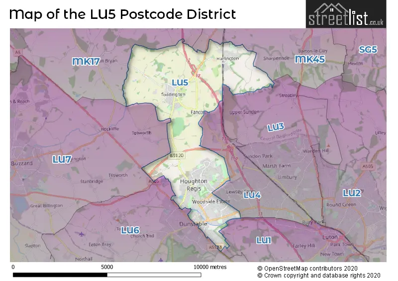
The LU5 Postcode shares a border with LU1 (LUTON, Caddington, Slip End), LU3 (LUTON, Sundon), LU4 (LUTON, Chalton, Leagrave), LU6 (DUNSTABLE, Eaton Bray, Edlesborough), LU7 (LEIGHTON BUZZARD, Pitstone, Wing), MK45 (Flitwick, Ampthill, Barton-le-Clay) and MK17 (Woburn Sands, Glebe Farm, Newton Longville).
In the LU5 postcode district, the primary settlement is Dunstable, located in the county of Bedfordshire in England. The most significant postal town is Dunstable, which has the highest number of postcodes. Other significant settlements include Houghton Regis, Harlington, and Toddington.
For the district LU5, we have data on 4 postcode sectors. Here's a breakdown: The sector LU5 4, covers Dunstable in Bedfordshire. The sector LU5 5, covers Houghton Regis in Bedfordshire. The sector LU5 6, covers Toddington and Harlington and Houghton Regis in Bedfordshire. The sector LU5 7 is non-geographic. It's often designated for PO Boxes, large organisations, or special services.

Map of the LU5 Postcode District
Explore the LU5 postcode district by using our free interactive map.
When it comes to local government, postal geography often disregards political borders. However, for a breakdown in the LU5 District: the district mostly encompasses the Central Bedfordshire area with a total of 778 postcodes.
Recent House Sales in LU5
| Date | Price | Address |
|---|---|---|
| 26/10/2023 | £400,000 | Brandreth Avenue, Dunstable, LU5 4JP |
| 04/10/2023 | £315,000 | Drury Lane, Houghton Regis, Dunstable, LU5 5ED |
| 04/10/2023 | £405,000 | Rowan Bank, Houghton Regis, Dunstable, LU5 7AL |
| 29/09/2023 | £300,000 | Farm Close, Houghton Regis, Dunstable, LU5 5EG |
| 28/09/2023 | £55,000 | Church Street, Dunstable, LU5 4FG |
| 22/09/2023 | £390,000 | Duncombe Drive, Dunstable, LU5 4QZ |
| 15/09/2023 | £390,000 | Russell Road, Toddington, Dunstable, LU5 6QF |
| 15/09/2023 | £120,000 | Squires Place, Toddington, Dunstable, LU5 6ET |
| 14/09/2023 | £1,450,000 | Park Road, Toddington, Dunstable, LU5 6AB |
| 08/09/2023 | £440,000 | Great Northern Road, Dunstable, LU5 4BT |
Weather Forecast for LU5
Press Button to Show Forecast for Houghton Regis
| Time Period | Icon | Description | Temperature | Rain Probability | Wind |
|---|---|---|---|---|---|
| 03:00 to 06:00 | Clear night | 2.0°C (feels like 0.0°C) | 2.00% | NE 4 mph | |
| 06:00 to 09:00 | Sunny day | 2.0°C (feels like 0.0°C) | 1.00% | NE 4 mph | |
| 09:00 to 12:00 | Partly cloudy (day) | 6.0°C (feels like 4.0°C) | 2.00% | ENE 7 mph | |
| 12:00 to 15:00 | Cloudy | 9.0°C (feels like 8.0°C) | 7.00% | ENE 7 mph | |
| 15:00 to 18:00 | Overcast | 10.0°C (feels like 9.0°C) | 12.00% | NE 4 mph | |
| 18:00 to 21:00 | Cloudy | 8.0°C (feels like 6.0°C) | 10.00% | ENE 7 mph | |
| 21:00 to 00:00 | Cloudy | 5.0°C (feels like 3.0°C) | 11.00% | ENE 7 mph |
Press Button to Show Forecast for Houghton Regis
| Time Period | Icon | Description | Temperature | Rain Probability | Wind |
|---|---|---|---|---|---|
| 00:00 to 03:00 | Cloudy | 4.0°C (feels like 1.0°C) | 11.00% | ENE 7 mph | |
| 03:00 to 06:00 | Cloudy | 3.0°C (feels like 0.0°C) | 15.00% | ENE 7 mph | |
| 06:00 to 09:00 | Cloudy | 3.0°C (feels like 1.0°C) | 20.00% | NE 7 mph | |
| 09:00 to 12:00 | Cloudy | 8.0°C (feels like 5.0°C) | 18.00% | ENE 9 mph | |
| 12:00 to 15:00 | Cloudy | 10.0°C (feels like 8.0°C) | 17.00% | ENE 9 mph | |
| 15:00 to 18:00 | Overcast | 11.0°C (feels like 9.0°C) | 20.00% | E 11 mph | |
| 18:00 to 21:00 | Cloudy | 10.0°C (feels like 8.0°C) | 19.00% | ENE 11 mph | |
| 21:00 to 00:00 | Light rain | 8.0°C (feels like 5.0°C) | 54.00% | NE 11 mph |
Press Button to Show Forecast for Houghton Regis
| Time Period | Icon | Description | Temperature | Rain Probability | Wind |
|---|---|---|---|---|---|
| 00:00 to 03:00 | Heavy rain | 7.0°C (feels like 4.0°C) | 73.00% | NE 11 mph | |
| 03:00 to 06:00 | Heavy rain | 7.0°C (feels like 5.0°C) | 77.00% | NE 9 mph | |
| 06:00 to 09:00 | Light rain | 8.0°C (feels like 6.0°C) | 53.00% | SE 9 mph | |
| 09:00 to 12:00 | Light rain | 10.0°C (feels like 7.0°C) | 51.00% | ESE 9 mph | |
| 12:00 to 15:00 | Heavy rain shower (day) | 11.0°C (feels like 9.0°C) | 61.00% | SE 9 mph | |
| 15:00 to 18:00 | Light rain shower (day) | 12.0°C (feels like 10.0°C) | 41.00% | S 11 mph | |
| 18:00 to 21:00 | Light rain shower (day) | 10.0°C (feels like 8.0°C) | 37.00% | W 11 mph | |
| 21:00 to 00:00 | Cloudy | 8.0°C (feels like 6.0°C) | 9.00% | WSW 7 mph |
Where is the LU5 Postcode District?
The postcode district LU5 is located in Dunstable, which is a town in the United Kingdom. Dunstable is situated near several other towns, including Luton to the south-east (approximately 5.6 miles away), Leighton Buzzard to the west (approximately 6.2 miles away), Hitchin to the east (approximately 9.7 miles away), Shefford to the north-east (approximately 10.8 miles away), Berkhamsted to the south (approximately 11.7 miles away), Bedford to the north (approximately 11.7 miles away), Milton Keynes to the north-west (approximately 11.7 miles away), and Tring to the south-west (approximately 11.9 miles away). Moreover, the postcode district LU5 is around 34.1 miles away from the centre of London.
The district is within the post town of DUNSTABLE.
The sector has postcodes within the nation of England.
The LU5 Postcode District is in the Central Bedfordshire region of Bedfordshire and Hertfordshire within the East of England.
| Postcode Sector | Delivery Office |
|---|---|
| LU5 4 | Dunstable Delivery Office |
| LU5 5 | Dunstable Delivery Office |
| LU5 6 | Dunstable Delivery Office |
| LU5 6 | Toddington Scale Payment Delivery Office |
| L | U | 5 | - | X | X | X |
| L | U | 5 | Space | Numeric | Letter | Letter |
Current Monthly Rental Prices
| # Bedrooms | Min Price | Max Price | Avg Price |
|---|---|---|---|
| 1 | £550 | £1,500 | £1,000 |
| 2 | £1,050 | £1,200 | £1,138 |
| 3 | £1,300 | £2,400 | £1,506 |
| 4 | £1,400 | £3,400 | £2,521 |
Current House Prices
| # Bedrooms | Min Price | Max Price | Avg Price |
|---|---|---|---|
| £15,000 | £1,500,000 | £329,000 | |
| 1 | £59,750 | £240,000 | £151,712 |
| 2 | £63,500 | £550,000 | £237,989 |
| 3 | £190,000 | £735,000 | £376,631 |
| 4 | £315,000 | £1,100,000 | £507,061 |
| 5 | £400,000 | £1,200,000 | £739,458 |
| 6 | £1,500,000 | £1,500,000 | £1,500,000 |
| 10 | £2,100,000 | £2,100,000 | £2,100,000 |
Estate Agents who Operate in the LU5 District
| Logo | Name | Brand Name | Address | Contact Number | Total Properties |
|---|---|---|---|---|---|
 | Dunstable | Deakin-White | The Quadrant Shopping Centre, Dunstable, LU5 4RH | 01582 377837 | 41 |
 | Dunstable | Connells | 19 High Street North, Dunstable, LU6 1HX | 01582 377795 | 29 |
 | Dunstable | Household Estate Agents | 15b High Street North, Dunstable, LU6 1HX | 01582 377634 | 23 |
 | Dunstable | Alexander & Co | 3 West Street Dunstable LU6 1SL | 01582 297501 | 21 |
 | Dunstable | Taylors Estate Agents | 2 High Street South, Dunstable, Bedfordshire, LU6 3HA | 01582 377688 | 18 |
| Type of Property | 2018 Average | 2018 Sales | 2017 Average | 2017 Sales | 2016 Average | 2016 Sales | 2015 Average | 2015 Sales |
|---|---|---|---|---|---|---|---|---|
| Detached | £404,388 | 101 | £385,944 | 97 | £381,074 | 101 | £352,264 | 84 |
| Semi-Detached | £294,458 | 235 | £288,179 | 243 | £270,851 | 249 | £232,997 | 194 |
| Terraced | £244,252 | 221 | £240,406 | 254 | £220,398 | 296 | £183,732 | 277 |
| Flats | £163,031 | 79 | £156,273 | 127 | £143,442 | 165 | £132,278 | 136 |