The M25 2 postcode sector is within the county of Greater Manchester.
Did you know? According to the 2021 Census, the M25 2 postcode sector is home to a bustling 3,629 residents!
Given that each sector allows for 400 unique postcode combinations. Letters C, I, K, M, O and V are not allowed in the last two letters of a postcode. With 74 postcodes already in use, this leaves 326 units available.
The M25 2 postal code covers the settlement of Prestwich.
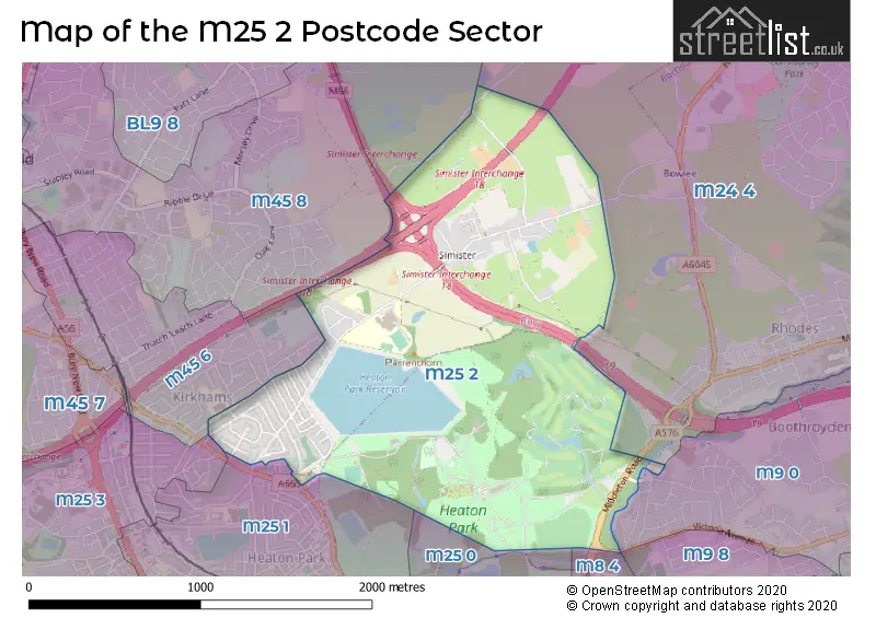
The M25 2 Postcode shares a border with M8 4 (MANCHESTER, Crumpsall), M25 0 (Prestwich), M25 3 (Prestwich), BL9 8 (BURY, Unsworth), M9 0 (MANCHESTER), M9 8 (MANCHESTER), M24 4 (Middleton), M25 1 (Prestwich), M45 6 (Whitefield) and M45 8 (Whitefield).
The sector is within the post town of MANCHESTER.
M25 2 is a postcode sector within the M25 postcode district which is within the M Manchester postcode area.
The Royal Mail delivery office for the M25 2 postal sector is the Prestwich Delivery Office.
The area of the M25 2 postcode sector is 1.50 square miles which is 3.88 square kilometres or 959.20 square acres.
The M25 2 postcode sector is crossed by the M66 motorway.
The M25 2 postcode sector is crossed by the M60 motorway.
The M25 2 postcode sector is crossed by the M62 motorway.
Waterways within the M25 2 postcode sector include the River Irk.

Map of the M25 2 Postcode Sector
Explore the M25 2 postcode sector by using our free interactive map.
| M | 2 | 5 | - | 2 | X | X |
| M | 2 | 5 | Space | 2 | Letter | Letter |
Official List of Streets
Prestwich (42 Streets)
Unofficial Streets or Alternative Spellings
Whitefield
BEESTON GROVE RAGLAN AVENUE SANDGATE ROADMiddleton
MIDDLETON ROAD SIMISTER LANEMANCHESTER
HEATON PARK ROAD WEST VICTORIA AVENUE BRIDLE ROAD CUCKOO GROVE SAGE ROAD SIMISTER ISLAND VICTORIA AVENUE BRIDGEWeather Forecast for M25 2
Press Button to Show Forecast for Heaton Hall
| Time Period | Icon | Description | Temperature | Rain Probability | Wind |
|---|---|---|---|---|---|
| 21:00 to 00:00 | Cloudy | 6.0°C (feels like 4.0°C) | 4.00% | ENE 7 mph |
Press Button to Show Forecast for Heaton Hall
| Time Period | Icon | Description | Temperature | Rain Probability | Wind |
|---|---|---|---|---|---|
| 00:00 to 03:00 | Partly cloudy (night) | 5.0°C (feels like 3.0°C) | 1.00% | ENE 7 mph | |
| 03:00 to 06:00 | Partly cloudy (night) | 4.0°C (feels like 2.0°C) | 1.00% | NE 7 mph | |
| 06:00 to 09:00 | Partly cloudy (day) | 4.0°C (feels like 2.0°C) | 2.00% | NE 7 mph | |
| 09:00 to 12:00 | Cloudy | 8.0°C (feels like 5.0°C) | 5.00% | ENE 9 mph | |
| 12:00 to 15:00 | Cloudy | 10.0°C (feels like 8.0°C) | 5.00% | ENE 9 mph | |
| 15:00 to 18:00 | Light rain | 9.0°C (feels like 7.0°C) | 46.00% | ENE 9 mph | |
| 18:00 to 21:00 | Cloudy | 8.0°C (feels like 6.0°C) | 7.00% | ENE 9 mph | |
| 21:00 to 00:00 | Cloudy | 7.0°C (feels like 5.0°C) | 5.00% | NE 7 mph |
Press Button to Show Forecast for Heaton Hall
| Time Period | Icon | Description | Temperature | Rain Probability | Wind |
|---|---|---|---|---|---|
| 00:00 to 03:00 | Cloudy | 6.0°C (feels like 3.0°C) | 4.00% | NE 9 mph | |
| 03:00 to 06:00 | Cloudy | 5.0°C (feels like 2.0°C) | 6.00% | NNE 7 mph | |
| 06:00 to 09:00 | Cloudy | 6.0°C (feels like 3.0°C) | 13.00% | N 7 mph | |
| 09:00 to 12:00 | Cloudy | 7.0°C (feels like 5.0°C) | 16.00% | NNW 7 mph | |
| 12:00 to 15:00 | Light rain | 9.0°C (feels like 7.0°C) | 46.00% | NW 9 mph | |
| 15:00 to 18:00 | Cloudy | 10.0°C (feels like 8.0°C) | 14.00% | WNW 11 mph | |
| 18:00 to 21:00 | Partly cloudy (day) | 10.0°C (feels like 8.0°C) | 5.00% | W 9 mph | |
| 21:00 to 00:00 | Clear night | 7.0°C (feels like 5.0°C) | 3.00% | WSW 7 mph |
Press Button to Show Forecast for Heaton Hall
| Time Period | Icon | Description | Temperature | Rain Probability | Wind |
|---|---|---|---|---|---|
| 00:00 to 03:00 | Clear night | 6.0°C (feels like 4.0°C) | 1.00% | SSW 7 mph | |
| 03:00 to 06:00 | Clear night | 5.0°C (feels like 3.0°C) | 3.00% | SSE 7 mph | |
| 06:00 to 09:00 | Partly cloudy (day) | 6.0°C (feels like 3.0°C) | 4.00% | SSE 7 mph | |
| 09:00 to 12:00 | Partly cloudy (day) | 10.0°C (feels like 7.0°C) | 3.00% | S 11 mph | |
| 12:00 to 15:00 | Overcast | 13.0°C (feels like 10.0°C) | 11.00% | S 13 mph | |
| 15:00 to 18:00 | Overcast | 13.0°C (feels like 11.0°C) | 12.00% | S 13 mph | |
| 18:00 to 21:00 | Partly cloudy (day) | 13.0°C (feels like 11.0°C) | 8.00% | SSE 11 mph | |
| 21:00 to 00:00 | Clear night | 11.0°C (feels like 9.0°C) | 5.00% | SSE 9 mph |
Press Button to Show Forecast for Heaton Hall
| Time Period | Icon | Description | Temperature | Rain Probability | Wind |
|---|---|---|---|---|---|
| 00:00 to 03:00 | Clear night | 9.0°C (feels like 7.0°C) | 4.00% | SE 9 mph | |
| 03:00 to 06:00 | Cloudy | 8.0°C (feels like 6.0°C) | 5.00% | SE 9 mph | |
| 06:00 to 09:00 | Partly cloudy (day) | 9.0°C (feels like 6.0°C) | 3.00% | ESE 9 mph | |
| 09:00 to 12:00 | Sunny day | 12.0°C (feels like 10.0°C) | 4.00% | ESE 11 mph | |
| 12:00 to 15:00 | Cloudy | 15.0°C (feels like 12.0°C) | 8.00% | SE 13 mph | |
| 15:00 to 18:00 | Cloudy | 16.0°C (feels like 13.0°C) | 11.00% | SE 11 mph | |
| 18:00 to 21:00 | Partly cloudy (day) | 15.0°C (feels like 13.0°C) | 7.00% | ESE 11 mph | |
| 21:00 to 00:00 | Cloudy | 13.0°C (feels like 11.0°C) | 8.00% | E 9 mph |
Schools and Places of Education Within the M25 2 Postcode Sector
Parrenthorn High School
Community school
Heywood Road, Manchester, , M25 2BW
Head: Mr Christopher Bell
Ofsted Rating: Good
Inspection: 2023-03-08 (415 days ago)
Website: Visit Parrenthorn High School Website
Phone: 01617738634
Number of Pupils: 1011
St Margaret's Church of England Primary School
Voluntary controlled school
Heywood Road, Manchester, , M25 2BW
Head: Mr A Longworth
Ofsted Rating: Good
Inspection: 2019-11-06 (1633 days ago)
Website: Visit St Margaret's Church of England Primary School Website
Phone: 01617731432
Number of Pupils: 235
House Prices in the M25 2 Postcode Sector
| Type of Property | 2018 Average | 2018 Sales | 2017 Average | 2017 Sales | 2016 Average | 2016 Sales | 2015 Average | 2015 Sales |
|---|---|---|---|---|---|---|---|---|
| Detached | £447,500 | 2 | £238,667 | 6 | £280,000 | 3 | £305,667 | 3 |
| Semi-Detached | £225,018 | 25 | £195,068 | 29 | £168,650 | 28 | £176,641 | 26 |
| Terraced | £169,480 | 9 | £125,186 | 11 | £133,450 | 10 | £133,402 | 17 |
| Flats | £105,000 | 1 | £0 | 0 | £0 | 0 | £0 | 0 |
Important Postcodes M25 2 in the Postcode Sector
M25 2BW is the postcode for Parrenthorn High School, Heywood Road, Prestwich, St. Margarets C of E Primary School, Heywood Road, Prestwich, and St. Margarets C of E Primary School, Heywood Road
M25 2GR is the postcode for Parrenthorn High School, Heywood Road, Prestwich, and Parrenthorn High School, Heywood Road
| The M25 2 Sector is within these Local Authorities |
|
|---|---|
| The M25 2 Sector is within these Counties |
|
| The M25 2 Sector is within these Water Company Areas |
|