The MK5 postcode district is a postal district located in the MK Milton Keynes postcode area with a population of 15,845 residents according to the 2021 England and Wales Census.
The area of the MK5 postcode district is 2.71 square miles which is 7.03 square kilometres or 1,736.87 acres.
Currently, the MK5 district has about 409 postcode units spread across 3 geographic postcode sectors.
Given that each sector allows for 400 unique postcode combinations, the district has a capacity of 1,200 postcodes. With 409 postcodes already in use, this leaves 791 units available.
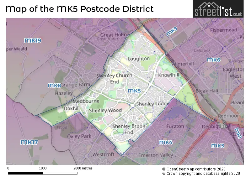
The largest settlement in the MK5 postal code is Shenley Church End followed by Shenley Lodge, and Loughton.
The MK5 Postcode shares a border with MK4 (Furzton, Emerson Valley, Tattenhoe), MK8 (Whitehouse, Two Mile Ash, Great Holm), MK17 (Woburn Sands, Glebe Farm, Newton Longville) and MK3 (Bletchley).
The primary settlement in the MK5 postcode district is Shenley Church End in Milton Keynes, Buckinghamshire. Other significant settlements include Medbourne, Oakhill, Shenley Wood, Shenley Brook End, Shenley Lodge, Elfield Park, Knowlhill, and Loughton. The post town for all these settlements is Milton Keynes, Buckinghamshire. The county is the county of Buckinghamshire in England.
For the district MK5, we have data on 3 postcode sectors. Here's a breakdown: The sector MK5 6, covers Shenley Church End and Medbourne in Buckinghamshire. The sector MK5 7, covers Shenley Lodge and Shenley Brook End in Buckinghamshire. The sector MK5 8, covers Loughton and Knowlhill in Buckinghamshire.


Map of the MK5 Postcode District
Explore the MK5 postcode district by using our free interactive map.
When it comes to local government, postal geography often disregards political borders. However, for a breakdown in the MK5 District: the district mostly encompasses the Milton Keynes (B) area with a total of 409 postcodes.
Recent House Sales in MK5
| Date | Price | Address |
|---|---|---|
| 24/10/2023 | £370,000 | Minorca Grove, Shenley Brook End, Milton Keynes, MK5 7FU |
| 13/10/2023 | £420,000 | Mansell Close, Shenley Church End, Milton Keynes, MK5 6AD |
| 26/09/2023 | £425,000 | Langport Crescent, Oakhill, Milton Keynes, MK5 6LZ |
| 14/09/2023 | £550,000 | Bremen Grove, Shenley Brook End, Milton Keynes, MK5 7FJ |
| 25/08/2023 | £477,000 | Faraday Drive, Shenley Lodge, Milton Keynes, MK5 7DD |
| 25/08/2023 | £1,057,335 | Snaith Crescent, Loughton, Milton Keynes, MK5 8HQ |
| 21/08/2023 | £800,000 | Linceslade Grove, Loughton, Milton Keynes, MK5 8BL |
| 18/08/2023 | £710,000 | Greylag Gardens, Shenley Brook End, Milton Keynes, MK5 7GX |
| 15/08/2023 | £525,000 | Mayer Gardens, Shenley Lodge, Milton Keynes, MK5 7EN |
| 15/08/2023 | £650,000 | Sebright Close, Shenley Brook End, Milton Keynes, MK5 7GW |
Weather Forecast for MK5
Press Button to Show Forecast for Shenley Brook End
| Time Period | Icon | Description | Temperature | Rain Probability | Wind |
|---|---|---|---|---|---|
| 18:00 to 21:00 | Cloudy | 9.0°C (feels like 6.0°C) | 6.00% | NE 11 mph | |
| 21:00 to 00:00 | Cloudy | 7.0°C (feels like 4.0°C) | 7.00% | ENE 9 mph |
Press Button to Show Forecast for Shenley Brook End
| Time Period | Icon | Description | Temperature | Rain Probability | Wind |
|---|---|---|---|---|---|
| 00:00 to 03:00 | Cloudy | 6.0°C (feels like 3.0°C) | 9.00% | ENE 9 mph | |
| 03:00 to 06:00 | Cloudy | 5.0°C (feels like 2.0°C) | 12.00% | NE 9 mph | |
| 06:00 to 09:00 | Overcast | 5.0°C (feels like 2.0°C) | 48.00% | NE 9 mph | |
| 09:00 to 12:00 | Overcast | 6.0°C (feels like 3.0°C) | 50.00% | NE 11 mph | |
| 12:00 to 15:00 | Overcast | 8.0°C (feels like 5.0°C) | 15.00% | ENE 11 mph | |
| 15:00 to 18:00 | Overcast | 9.0°C (feels like 6.0°C) | 12.00% | NE 11 mph | |
| 18:00 to 21:00 | Overcast | 8.0°C (feels like 6.0°C) | 21.00% | NE 13 mph | |
| 21:00 to 00:00 | Heavy rain | 7.0°C (feels like 4.0°C) | 86.00% | NNE 13 mph |
Press Button to Show Forecast for Shenley Brook End
| Time Period | Icon | Description | Temperature | Rain Probability | Wind |
|---|---|---|---|---|---|
| 00:00 to 03:00 | Heavy rain | 7.0°C (feels like 3.0°C) | 86.00% | NNE 13 mph | |
| 03:00 to 06:00 | Heavy rain | 7.0°C (feels like 3.0°C) | 90.00% | NNE 13 mph | |
| 06:00 to 09:00 | Heavy rain | 6.0°C (feels like 3.0°C) | 89.00% | NNW 11 mph | |
| 09:00 to 12:00 | Heavy rain | 7.0°C (feels like 4.0°C) | 81.00% | NW 11 mph | |
| 12:00 to 15:00 | Light rain | 8.0°C (feels like 4.0°C) | 53.00% | WNW 11 mph | |
| 15:00 to 18:00 | Cloudy | 9.0°C (feels like 7.0°C) | 16.00% | W 9 mph | |
| 18:00 to 21:00 | Cloudy | 9.0°C (feels like 8.0°C) | 7.00% | WSW 7 mph | |
| 21:00 to 00:00 | Partly cloudy (night) | 7.0°C (feels like 5.0°C) | 3.00% | SSW 7 mph |
Press Button to Show Forecast for Shenley Brook End
| Time Period | Icon | Description | Temperature | Rain Probability | Wind |
|---|---|---|---|---|---|
| 00:00 to 03:00 | Clear night | 5.0°C (feels like 3.0°C) | 2.00% | SW 7 mph | |
| 03:00 to 06:00 | Clear night | 4.0°C (feels like 2.0°C) | 1.00% | SSW 7 mph | |
| 06:00 to 09:00 | Sunny day | 5.0°C (feels like 3.0°C) | 1.00% | S 7 mph | |
| 09:00 to 12:00 | Partly cloudy (day) | 11.0°C (feels like 8.0°C) | 1.00% | S 11 mph | |
| 12:00 to 15:00 | Cloudy | 13.0°C (feels like 10.0°C) | 6.00% | S 11 mph | |
| 15:00 to 18:00 | Partly cloudy (day) | 14.0°C (feels like 11.0°C) | 2.00% | S 11 mph | |
| 18:00 to 21:00 | Sunny day | 13.0°C (feels like 11.0°C) | 1.00% | S 9 mph | |
| 21:00 to 00:00 | Clear night | 8.0°C (feels like 7.0°C) | 1.00% | SSE 7 mph |
Press Button to Show Forecast for Shenley Brook End
| Time Period | Icon | Description | Temperature | Rain Probability | Wind |
|---|---|---|---|---|---|
| 00:00 to 03:00 | Clear night | 7.0°C (feels like 5.0°C) | 2.00% | SE 7 mph | |
| 03:00 to 06:00 | Clear night | 7.0°C (feels like 5.0°C) | 3.00% | SE 9 mph | |
| 06:00 to 09:00 | Sunny day | 8.0°C (feels like 6.0°C) | 3.00% | ESE 7 mph | |
| 09:00 to 12:00 | Sunny day | 13.0°C (feels like 11.0°C) | 3.00% | SE 9 mph | |
| 12:00 to 15:00 | Partly cloudy (day) | 16.0°C (feels like 13.0°C) | 5.00% | SE 11 mph | |
| 15:00 to 18:00 | Cloudy | 16.0°C (feels like 14.0°C) | 8.00% | SE 9 mph | |
| 18:00 to 21:00 | Cloudy | 15.0°C (feels like 13.0°C) | 10.00% | ESE 9 mph | |
| 21:00 to 00:00 | Clear night | 12.0°C (feels like 10.0°C) | 7.00% | ESE 7 mph |
Where is the MK5 Postcode District?
The postcode district MK5 is located in Milton Keynes, a town in the vicinity of several other towns in different directions. It is approximately 5.27 miles northeast of Newport Pagnell, 7.66 miles west of Buckingham, 9.22 miles southeast of Leighton Buzzard, 10.53 miles north of Olney, 12.20 miles northwest of Towcester, 14.72 miles south of Aylesbury, and 15.16 miles east of Bedford. Furthermore, Milton Keynes is situated around 45.35 miles away from the center of London.
The district is within the post town of MILTON KEYNES.
The sector has postcodes within the nation of England.
The MK5 Postcode District is in the Milton Keynes region of Berkshire, Buckinghamshire and Oxfordshire within the South East (England).
| Postcode Sector | Delivery Office |
|---|---|
| MK5 6 | Bletchley Delivery Office |
| MK5 7 | Bletchley Delivery Office |
| MK5 8 | Bletchley Delivery Office |
| M | K | 5 | - | X | X | X |
| M | K | 5 | Space | Numeric | Letter | Letter |
Current Monthly Rental Prices
| # Bedrooms | Min Price | Max Price | Avg Price |
|---|---|---|---|
| £850 | £1,150 | £1,000 | |
| 1 | £825 | £2,500 | £1,331 |
| 2 | £1,950 | £1,950 | £1,950 |
| 3 | £1,395 | £1,800 | £1,568 |
| 4 | £2,050 | £4,000 | £3,009 |
| 5 | £2,350 | £2,650 | £2,550 |
Current House Prices
| # Bedrooms | Min Price | Max Price | Avg Price |
|---|---|---|---|
| 1 | £85,000 | £225,000 | £161,667 |
| 2 | £115,000 | £300,000 | £202,142 |
| 3 | £183,000 | £700,000 | £376,996 |
| 4 | £365,000 | £1,300,000 | £634,571 |
| 5 | £600,000 | £1,500,000 | £873,632 |
| 6 | £31,000 | £1,750,000 | £1,017,769 |
Estate Agents who Operate in the MK5 District
| Logo | Name | Brand Name | Address | Contact Number | Total Properties |
|---|---|---|---|---|---|
 | Milton Keynes | Michael Graham | Midsummer House, 445 Midsummer Boulevard, Milton Keynes, MK9 3BN | 01908 103694 | 13 |
 | Oxley Park - West MK | Connells | 64 Redgrave Drive, Oxley Park, Milton Keynes, MK4 4TB | 01908 103948 | 12 |
 | Milton Keynes | Cauldwell Property Services | The Vizion, 350 Avebury Boulevard, Milton Keynes, MK9 2JH | 01908 103401 | 11 |
 | Milton Keynes | Taylors Estate Agents | Central Business Exchange 436 Midsummer Boulevard Milton Keynes MK9 2EA | 01908 103600 | 5 |
 | Milton Keynes | Michael Anthony | 209A Witan Gate Milton Keynes MK9 2HP | 01908 103611 | 4 |
| Type of Property | 2018 Average | 2018 Sales | 2017 Average | 2017 Sales | 2016 Average | 2016 Sales | 2015 Average | 2015 Sales |
|---|---|---|---|---|---|---|---|---|
| Detached | £525,695 | 78 | £507,796 | 104 | £504,539 | 95 | £491,448 | 116 |
| Semi-Detached | £259,929 | 46 | £271,915 | 47 | £252,711 | 45 | £208,053 | 37 |
| Terraced | £262,053 | 28 | £247,816 | 38 | £252,858 | 44 | £246,561 | 41 |
| Flats | £186,468 | 37 | £156,472 | 45 | £154,594 | 60 | £145,574 | 51 |