The MK4 postcode district is a postal district located in the MK Milton Keynes postcode area with a population of 24,643 residents according to the 2021 England and Wales Census.
The area of the MK4 postcode district is 3.10 square miles which is 8.03 square kilometres or 1,985.40 acres.
Currently, the MK4 district has about 570 postcode units spread across 32 geographic postcode sectors.
Given that each sector allows for 400 unique postcode combinations, the district has a capacity of 12,800 postcodes. With 570 postcodes already in use, this leaves 12230 units available.
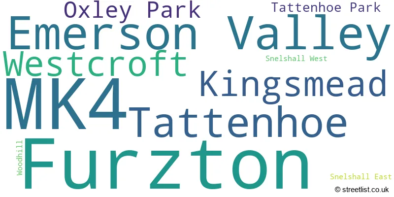
The largest settlement in the MK4 postal code is Furzton followed by Emerson Valley, and Tattenhoe.
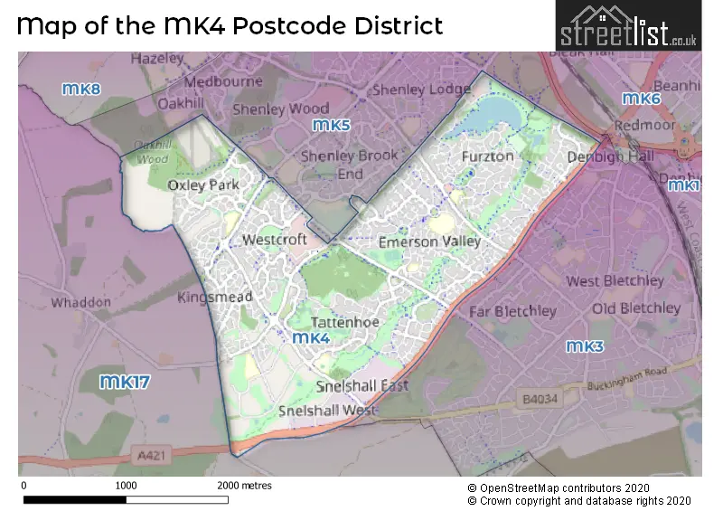
The MK4 Postcode shares a border with MK5 (Shenley Church End, Shenley Lodge, Loughton), MK17 (Woburn Sands, Glebe Farm, Newton Longville) and MK3 (Bletchley).
The primary settlement in the MK4 postcode district is Furzton, located in the county of Buckinghamshire. The most significant post town in the district is Milton Keynes. Other notable settlements include Emerson Valley, Tattenhoe, Kingsmead, Oxley Park, Westcroft, and Woodhill.
For the district MK4, we have data on 4 postcode sectors. Here's a breakdown: The sector MK4 1, covers Furzton in Buckinghamshire. The sector MK4 2, covers Emerson Valley in Buckinghamshire. The sector MK4 3, covers Tattenhoe in Buckinghamshire. The sector MK4 4, covers Kingsmead and Oxley Park and Westcroft in Buckinghamshire.

Map of the MK4 Postcode District
Explore the MK4 postcode district by using our free interactive map.
When it comes to local government, postal geography often disregards political borders. However, for a breakdown in the MK4 District: the district mostly encompasses the Milton Keynes (B) area with a total of 591 postcodes.
Recent House Sales in MK42
| Date | Price | Address |
|---|---|---|
| 09/10/2023 | £293,000 | Wilstead Road, Elstow, Bedford, MK42 9YQ |
| 06/10/2023 | £305,000 | Stuart Road, Kempston, Bedford, MK42 8HS |
| 28/09/2023 | £368,000 | Oliver Close, Kempston, Bedford, MK42 7FW |
| 22/09/2023 | £550,000 | Spring Road, Kempston, Bedford, MK42 8LR |
| 20/09/2023 | £410,000 | Ripon Close, Kempston, Bedford, MK42 8UZ |
| 14/09/2023 | £183,000 | Kingfisher Road, Wixams, Bedford, MK42 6AY |
| 12/09/2023 | £252,000 | Stafford Road, Bedford, MK42 9EA |
| 11/09/2023 | £535,000 | Crowsley Road, Kempston, Bedford, MK42 7FN |
| 08/09/2023 | £175,000 | Camford Court, Kempston, Bedford, MK42 7AH |
| 08/09/2023 | £290,000 | Teal Close, Wixams, Bedford, MK42 6AL |
Weather Forecast for MK4
Press Button to Show Forecast for Tattenhoe
| Time Period | Icon | Description | Temperature | Rain Probability | Wind |
|---|---|---|---|---|---|
| 09:00 to 12:00 | Overcast | 7.0°C (feels like 3.0°C) | 51.00% | NE 11 mph | |
| 12:00 to 15:00 | Overcast | 8.0°C (feels like 5.0°C) | 14.00% | ENE 11 mph | |
| 15:00 to 18:00 | Overcast | 9.0°C (feels like 7.0°C) | 13.00% | NE 11 mph | |
| 18:00 to 21:00 | Overcast | 9.0°C (feels like 6.0°C) | 21.00% | NE 11 mph | |
| 21:00 to 00:00 | Heavy rain | 7.0°C (feels like 4.0°C) | 85.00% | NNE 11 mph |
Press Button to Show Forecast for Tattenhoe
| Time Period | Icon | Description | Temperature | Rain Probability | Wind |
|---|---|---|---|---|---|
| 00:00 to 03:00 | Heavy rain | 7.0°C (feels like 3.0°C) | 85.00% | NNE 13 mph | |
| 03:00 to 06:00 | Heavy rain | 7.0°C (feels like 3.0°C) | 90.00% | NNE 13 mph | |
| 06:00 to 09:00 | Heavy rain | 6.0°C (feels like 3.0°C) | 89.00% | NNW 11 mph | |
| 09:00 to 12:00 | Heavy rain | 7.0°C (feels like 4.0°C) | 81.00% | NW 11 mph | |
| 12:00 to 15:00 | Light rain | 8.0°C (feels like 5.0°C) | 53.00% | WNW 11 mph | |
| 15:00 to 18:00 | Cloudy | 9.0°C (feels like 7.0°C) | 16.00% | W 9 mph | |
| 18:00 to 21:00 | Cloudy | 9.0°C (feels like 8.0°C) | 7.00% | WSW 7 mph | |
| 21:00 to 00:00 | Partly cloudy (night) | 7.0°C (feels like 5.0°C) | 3.00% | SSW 7 mph |
Press Button to Show Forecast for Tattenhoe
| Time Period | Icon | Description | Temperature | Rain Probability | Wind |
|---|---|---|---|---|---|
| 00:00 to 03:00 | Clear night | 6.0°C (feels like 3.0°C) | 2.00% | SW 7 mph | |
| 03:00 to 06:00 | Clear night | 4.0°C (feels like 2.0°C) | 1.00% | SSW 7 mph | |
| 06:00 to 09:00 | Sunny day | 5.0°C (feels like 3.0°C) | 1.00% | S 7 mph | |
| 09:00 to 12:00 | Partly cloudy (day) | 11.0°C (feels like 9.0°C) | 1.00% | S 11 mph | |
| 12:00 to 15:00 | Cloudy | 13.0°C (feels like 10.0°C) | 7.00% | S 11 mph | |
| 15:00 to 18:00 | Partly cloudy (day) | 14.0°C (feels like 11.0°C) | 2.00% | S 13 mph | |
| 18:00 to 21:00 | Sunny day | 13.0°C (feels like 11.0°C) | 1.00% | S 9 mph | |
| 21:00 to 00:00 | Clear night | 8.0°C (feels like 7.0°C) | 1.00% | SSE 7 mph |
Press Button to Show Forecast for Tattenhoe
| Time Period | Icon | Description | Temperature | Rain Probability | Wind |
|---|---|---|---|---|---|
| 00:00 to 03:00 | Clear night | 7.0°C (feels like 5.0°C) | 2.00% | SE 7 mph | |
| 03:00 to 06:00 | Clear night | 7.0°C (feels like 5.0°C) | 3.00% | SE 7 mph | |
| 06:00 to 09:00 | Sunny day | 8.0°C (feels like 6.0°C) | 3.00% | ESE 7 mph | |
| 09:00 to 12:00 | Sunny day | 13.0°C (feels like 11.0°C) | 3.00% | SE 9 mph | |
| 12:00 to 15:00 | Partly cloudy (day) | 16.0°C (feels like 13.0°C) | 5.00% | SE 11 mph | |
| 15:00 to 18:00 | Cloudy | 16.0°C (feels like 14.0°C) | 8.00% | SE 9 mph | |
| 18:00 to 21:00 | Cloudy | 15.0°C (feels like 13.0°C) | 10.00% | ESE 9 mph | |
| 21:00 to 00:00 | Clear night | 12.0°C (feels like 10.0°C) | 7.00% | ESE 7 mph |
Where is the MK4 Postcode District?
The postcode district MK4 is located in Milton Keynes. The nearby towns in relation to Milton Keynes are Newport Pagnell (6.34 miles to the North East), Buckingham (7.34 miles to the West), Leighton Buzzard (8.30 miles to the South East), Olney (11.70 miles to the North), Towcester (13.00 miles to the North West), and Aylesbury (13.53 miles to the South). Additionally, Milton Keynes is approximately 44.44 miles away from the centre of London.
The district is within the post town of MILTON KEYNES.
The sector has postcodes within the nation of England.
The MK4 Postcode District is in the Milton Keynes region of Berkshire, Buckinghamshire and Oxfordshire within the South East (England).
Postcode Sectors within the MK4 District
| Postcode Sector | Delivery Office |
|---|---|
| MK4 1 | Bletchley Delivery Office |
| MK4 2 | Bletchley Delivery Office |
| MK4 3 | Bletchley Delivery Office |
| MK4 4 | Bletchley Delivery Office |
| M | K | 4 | - | X | X | X |
| M | K | 4 | Space | Numeric | Letter | Letter |
Current Monthly Rental Prices
| # Bedrooms | Min Price | Max Price | Avg Price |
|---|---|---|---|
| 1 | £895 | £895 | £895 |
| 2 | £1,150 | £1,475 | £1,319 |
| 3 | £1,350 | £3,600 | £1,813 |
| 4 | £1,750 | £3,900 | £2,273 |
| 5 | £1,650 | £1,950 | £1,800 |
| 6 | £5,500 | £5,500 | £5,500 |
Current House Prices
| # Bedrooms | Min Price | Max Price | Avg Price |
|---|---|---|---|
| 1 | £70,000 | £230,000 | £188,182 |
| 2 | £66,000 | £350,000 | £221,868 |
| 3 | £280,000 | £515,000 | £398,773 |
| 4 | £375,000 | £900,000 | £531,922 |
| 5 | £425,000 | £1,350,000 | £819,706 |
| 6 | £650,000 | £735,000 | £696,250 |
Estate Agents who Operate in the MK4 District
| Logo | Name | Brand Name | Address | Contact Number | Total Properties |
|---|---|---|---|---|---|
 | Oxley Park - West MK | Connells | 64 Redgrave Drive, Oxley Park, Milton Keynes, MK4 4TB | 01908 103948 | 31 |
 | Milton Keynes | Cauldwell Property Services | The Vizion, 350 Avebury Boulevard, Milton Keynes, MK9 2JH | 01908 103401 | 13 |
 | Milton Keynes | Taylors Estate Agents | Central Business Exchange 436 Midsummer Boulevard Milton Keynes MK9 2EA | 01908 103600 | 8 |
 | Milton Keynes | Alan Francis | Sovereign Court, 213 Witan Gate, Milton Keynes MK9 2HP | 01908 103004 | 8 |
 | London | OpenRent | 39 Great Windmill Street London W1D 7LX | 020 3322 3265 | 7 |
| Type of Property | 2018 Average | 2018 Sales | 2017 Average | 2017 Sales | 2016 Average | 2016 Sales | 2015 Average | 2015 Sales |
|---|---|---|---|---|---|---|---|---|
| Detached | £471,387 | 166 | £446,520 | 185 | £424,890 | 149 | £381,778 | 178 |
| Semi-Detached | £280,763 | 103 | £269,462 | 107 | £250,289 | 90 | £229,208 | 90 |
| Terraced | £233,646 | 83 | £240,947 | 100 | £241,833 | 112 | £214,853 | 127 |
| Flats | £130,662 | 46 | £125,411 | 61 | £136,319 | 74 | £139,027 | 61 |