The MK7 postcode district is a postal district located in the MK Milton Keynes postcode area with a population of 14,790 residents according to the 2021 England and Wales Census.
The area of the MK7 postcode district is 2.57 square miles which is 6.65 square kilometres or 1,643.68 acres.
Currently, the MK7 district has about 373 postcode units spread across 3 geographic postcode sectors.
Given that each sector allows for 400 unique postcode combinations, the district has a capacity of 1,200 postcodes. With 373 postcodes already in use, this leaves 827 units available.
The largest settlement in the MK7 postal code is Walnut Tree followed by Kents Hill, and Wavendon Gate.
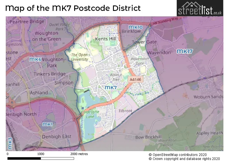
The MK7 Postcode shares a border with MK10 (Broughton, Brooklands, Monkston), MK17 (Woburn Sands, Glebe Farm, Newton Longville) and MK6 (Oldbrook, Fishermead, Netherfield).
The primary settlement in the MK7 postcode district is Walnut Tree, located in Milton Keynes, Buckinghamshire. Other significant settlements include Kents Hill, Walton Hall, Walton Park, and Wavendon Gate. The county is Buckinghamshire, and the post town is Milton Keynes, which is the most significant postal town in the district.
For the district MK7, we have data on 3 postcode sectors. Here's a breakdown: The sector MK7 6, covers Kents Hill and Walton Hall in Buckinghamshire. The sector MK7 7, covers Walnut Tree and Wavendon Gate and Walton Park in Buckinghamshire. The sector MK7 8, covers Old Farm Park and Caldecotte and Browns Wood in Buckinghamshire.

Map of the MK7 Postcode District
Explore the MK7 postcode district by using our free interactive map.
When it comes to local government, postal geography often disregards political borders. However, for a breakdown in the MK7 District: the district mostly encompasses the Milton Keynes (B) area with a total of 381 postcodes.
Recent House Sales in MK7
| Date | Price | Address |
|---|---|---|
| 06/10/2023 | £337,500 | Dunchurch Dale, Walnut Tree, Milton Keynes, MK7 7BT |
| 29/09/2023 | £240,000 | Holst Crescent, Browns Wood, Milton Keynes, MK7 8DQ |
| 27/09/2023 | £495,000 | The Nortons, Caldecotte, Milton Keynes, MK7 8HQ |
| 25/09/2023 | £149,000 | Pettingrew Close, Walnut Tree, Milton Keynes, MK7 7LL |
| 22/09/2023 | £395,000 | Longhedge, Caldecotte, Milton Keynes, MK7 8LA |
| 18/09/2023 | £300,000 | Balsam Close, Walnut Tree, Milton Keynes, MK7 7NB |
| 15/09/2023 | £535,000 | Groombridge, Kents Hill, Milton Keynes, MK7 6HA |
| 11/09/2023 | £305,000 | Mithras Gardens, Wavendon Gate, Milton Keynes, MK7 7SX |
| 01/09/2023 | £325,000 | Hindemith Gardens, Old Farm Park, Milton Keynes, MK7 8PN |
| 31/08/2023 | £270,000 | Moeran Close, Browns Wood, Milton Keynes, MK7 8DT |
Weather Forecast for MK7
Press Button to Show Forecast for Caldecotte
| Time Period | Icon | Description | Temperature | Rain Probability | Wind |
|---|---|---|---|---|---|
| 00:00 to 03:00 | Cloudy | 6.0°C (feels like 3.0°C) | 8.00% | ENE 7 mph | |
| 03:00 to 06:00 | Overcast | 5.0°C (feels like 2.0°C) | 15.00% | NE 9 mph | |
| 06:00 to 09:00 | Overcast | 5.0°C (feels like 2.0°C) | 23.00% | NE 9 mph | |
| 09:00 to 12:00 | Overcast | 7.0°C (feels like 4.0°C) | 50.00% | NE 11 mph | |
| 12:00 to 15:00 | Overcast | 8.0°C (feels like 5.0°C) | 14.00% | ENE 11 mph | |
| 15:00 to 18:00 | Overcast | 9.0°C (feels like 7.0°C) | 13.00% | NE 11 mph | |
| 18:00 to 21:00 | Overcast | 9.0°C (feels like 6.0°C) | 20.00% | NE 13 mph | |
| 21:00 to 00:00 | Heavy rain | 7.0°C (feels like 4.0°C) | 85.00% | NNE 11 mph |
Press Button to Show Forecast for Caldecotte
| Time Period | Icon | Description | Temperature | Rain Probability | Wind |
|---|---|---|---|---|---|
| 00:00 to 03:00 | Heavy rain | 7.0°C (feels like 4.0°C) | 86.00% | NNE 13 mph | |
| 03:00 to 06:00 | Heavy rain | 7.0°C (feels like 3.0°C) | 91.00% | NNE 13 mph | |
| 06:00 to 09:00 | Heavy rain | 7.0°C (feels like 4.0°C) | 87.00% | NNW 11 mph | |
| 09:00 to 12:00 | Heavy rain | 7.0°C (feels like 4.0°C) | 81.00% | NW 11 mph | |
| 12:00 to 15:00 | Light rain | 8.0°C (feels like 5.0°C) | 49.00% | WNW 11 mph | |
| 15:00 to 18:00 | Cloudy | 10.0°C (feels like 7.0°C) | 16.00% | W 9 mph | |
| 18:00 to 21:00 | Cloudy | 10.0°C (feels like 8.0°C) | 7.00% | WSW 7 mph | |
| 21:00 to 00:00 | Partly cloudy (night) | 7.0°C (feels like 5.0°C) | 3.00% | SSW 7 mph |
Press Button to Show Forecast for Caldecotte
| Time Period | Icon | Description | Temperature | Rain Probability | Wind |
|---|---|---|---|---|---|
| 00:00 to 03:00 | Clear night | 6.0°C (feels like 3.0°C) | 2.00% | SSW 7 mph | |
| 03:00 to 06:00 | Clear night | 4.0°C (feels like 2.0°C) | 1.00% | SSW 7 mph | |
| 06:00 to 09:00 | Sunny day | 6.0°C (feels like 3.0°C) | 1.00% | S 7 mph | |
| 09:00 to 12:00 | Partly cloudy (day) | 11.0°C (feels like 9.0°C) | 1.00% | S 11 mph | |
| 12:00 to 15:00 | Cloudy | 13.0°C (feels like 11.0°C) | 7.00% | S 11 mph | |
| 15:00 to 18:00 | Partly cloudy (day) | 14.0°C (feels like 12.0°C) | 3.00% | S 13 mph | |
| 18:00 to 21:00 | Sunny day | 13.0°C (feels like 11.0°C) | 1.00% | S 9 mph | |
| 21:00 to 00:00 | Clear night | 9.0°C (feels like 7.0°C) | 1.00% | SSE 7 mph |
Press Button to Show Forecast for Caldecotte
| Time Period | Icon | Description | Temperature | Rain Probability | Wind |
|---|---|---|---|---|---|
| 00:00 to 03:00 | Clear night | 8.0°C (feels like 6.0°C) | 2.00% | SE 7 mph | |
| 03:00 to 06:00 | Clear night | 7.0°C (feels like 5.0°C) | 3.00% | SE 7 mph | |
| 06:00 to 09:00 | Sunny day | 8.0°C (feels like 7.0°C) | 3.00% | ESE 7 mph | |
| 09:00 to 12:00 | Sunny day | 13.0°C (feels like 11.0°C) | 3.00% | SE 9 mph | |
| 12:00 to 15:00 | Cloudy | 16.0°C (feels like 14.0°C) | 7.00% | SE 11 mph | |
| 15:00 to 18:00 | Cloudy | 16.0°C (feels like 14.0°C) | 8.00% | SE 9 mph | |
| 18:00 to 21:00 | Cloudy | 15.0°C (feels like 13.0°C) | 11.00% | ESE 9 mph | |
| 21:00 to 00:00 | Clear night | 12.0°C (feels like 10.0°C) | 7.00% | ESE 7 mph |
Where is the MK7 Postcode District?
The postcode district MK7 is located in Milton Keynes, which is approximately 42.9 miles away from the center of London. In relation to nearby towns, MK7 is close to Newport Pagnell, Leighton Buzzard, Buckingham, Bedford, Dunstable, Shefford, and Towcester.
The district is within the post town of MILTON KEYNES.
The sector has postcodes within the nation of England.
The MK7 Postcode District is in the Milton Keynes region of Berkshire, Buckinghamshire and Oxfordshire within the South East (England).
| Postcode Sector | Delivery Office |
|---|---|
| MK7 6 | Brinklow (mk) Postal Delivery Office |
| MK7 7 | Brinklow (mk) Postal Delivery Office |
| MK7 8 | Brinklow (mk) Postal Delivery Office |
| M | K | 7 | - | X | X | X |
| M | K | 7 | Space | Numeric | Letter | Letter |
Current Monthly Rental Prices
| # Bedrooms | Min Price | Max Price | Avg Price |
|---|---|---|---|
| £775 | £775 | £775 | |
| 1 | £995 | £1,749 | £1,372 |
| 2 | £1,050 | £2,500 | £1,550 |
| 3 | £1,395 | £1,500 | £1,460 |
| 4 | £2,175 | £2,750 | £2,463 |
| 5 | £3,250 | £3,250 | £3,250 |
Current House Prices
| # Bedrooms | Min Price | Max Price | Avg Price |
|---|---|---|---|
| 1 | £160,000 | £235,000 | £189,444 |
| 2 | £135,000 | £375,000 | £273,333 |
| 3 | £320,000 | £480,000 | £394,353 |
| 4 | £435,000 | £895,000 | £605,102 |
| 5 | £525,000 | £1,250,000 | £888,125 |
| 6 | £1,000,000 | £1,000,000 | £1,000,000 |
| 7 | £1,150,000 | £1,150,000 | £1,150,000 |
Estate Agents who Operate in the MK7 District
| Logo | Name | Brand Name | Address | Contact Number | Total Properties |
|---|---|---|---|---|---|
 | Milton Keynes | Michael Graham | Midsummer House, 445 Midsummer Boulevard, Milton Keynes, MK9 3BN | 01908 103694 | 9 |
 | Walnut Tree | Connells | 26A Fyfield Barrow Walnut Tree Milton Keynes MK7 7AN | 01908 103761 | 8 |
 | Milton Keynes | Alan Francis | Sovereign Court, 213 Witan Gate, Milton Keynes MK9 2HP | 01908 103004 | 7 |
 | Milton Keynes | Cauldwell Property Services | The Vizion, 350 Avebury Boulevard, Milton Keynes, MK9 2JH | 01908 103401 | 6 |
 | Woburn Sands | Brown & Merry | 9 High Street, Woburn Sands, Buckinghamshire, MK17 8RG | 01908 103657 | 5 |
| Type of Property | 2018 Average | 2018 Sales | 2017 Average | 2017 Sales | 2016 Average | 2016 Sales | 2015 Average | 2015 Sales |
|---|---|---|---|---|---|---|---|---|
| Detached | £473,803 | 67 | £503,557 | 88 | £427,869 | 85 | £385,392 | 114 |
| Semi-Detached | £241,015 | 51 | £251,001 | 58 | £237,356 | 56 | £212,560 | 59 |
| Terraced | £197,384 | 39 | £198,832 | 52 | £214,467 | 48 | £180,521 | 58 |
| Flats | £134,636 | 47 | £122,011 | 47 | £97,272 | 32 | £134,111 | 61 |