
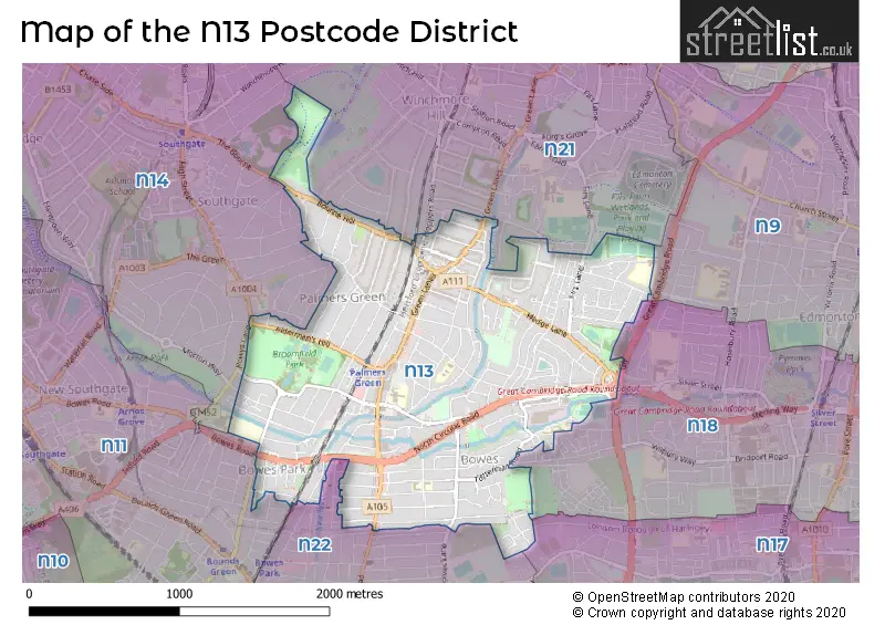
Map of the Postcode District
Explore the postcode district by using our interactive map.
Circles represent recorded crime; the larger the circle, the higher the crime rates.
Your support helps keep this site running!
If you enjoy using this website, consider buying me a coffee to help cover hosting costs.
The postcode district located in the N London - N postal area , N13 has a population of 33,667 residents according to the 2021 England and Wales Census.
The area of the district is 1.67 square miles (4.33 square kilometers or 1,070.61 acres).
Where is the N13 District?
To give you an idea where the district is located we have created the following table showing nearby towns.
Nearest Towns to N13
| Town | Distance (miles) | Direction |
|---|---|---|
| Waltham Cross | 5.60 | NNE |
| Cheshunt | 6.42 | NNE |
| Potters Bar | 6.56 | NW |
| Waltham Abbey | 7.03 | NE |
| City of London | 7.19 | S |
| Borehamwood | 7.65 | WNW |
| Chigwell | 7.75 | E |
| Loughton | 7.83 | ENE |
| City of Westminster | 8.15 | S |
| Radlett | 10.25 | WNW |
| Hoddesdon | 10.47 | NNE |
| Epping | 10.78 | ENE |
| Hatfield | 11.31 | NNW |
| Bushey | 11.34 | W |
| Hertford | 12.42 | N |
| Watford | 12.79 | WNW |
| Harlow | 13.51 | NE |
| Welwyn Garden City | 13.56 | NNW |
| St Albans | 13.70 | NW |
| Ware | 13.86 | NNE |
The post town for this district is LONDON.
Postcode Information for District N13 (Total Geographical Postcodes: 534)
| Location | Post Town | Sector | Number of Postcodes |
|---|---|---|---|
| Enfield | LONDON | N13 5 | 236 |
| Enfield | LONDON | N13 4 | 209 |
| Enfield | LONDON | N13 6 | 84 |
| Haringey | LONDON | N13 6 | 5 |
Retail and Shopping in N13
Street
Town
Locality
Number of Shops
Central Postcode
View on Google Maps
GREEN LANES
LONDON
256
N13 4YB
View on Google Maps
ALDERMANS HILL
LONDON
43
N13 4PN
View on Google Maps
BOWES ROAD
LONDON
20
N13 4SB
View on Google Maps
NORTH CIRCULAR ROAD
LONDON
13
N13 5ED
View on Google Maps
FIRS LANE
LONDON
7
N13 5QQ
View on Google Maps
CHEQUERS WAY
LONDON
6
N13 6BX
View on Google Maps
| Street | Town | Locality | Number of Shops | Central Postcode | View on Google Maps |
|---|---|---|---|---|---|
| GREEN LANES | LONDON | 256 | N13 4YB | View on Google Maps | |
| ALDERMANS HILL | LONDON | 43 | N13 4PN | View on Google Maps | |
| BOWES ROAD | LONDON | 20 | N13 4SB | View on Google Maps | |
| NORTH CIRCULAR ROAD | LONDON | 13 | N13 5ED | View on Google Maps | |
| FIRS LANE | LONDON | 7 | N13 5QQ | View on Google Maps | |
| CHEQUERS WAY | LONDON | 6 | N13 6BX | View on Google Maps |
The primary settlement in the N13 postcode district is Enfield, located in the borough of London. It is part of Greater London. Other significant settlements in the district include Haringey, also located in London. The most significant post town in the N13 postcode district is London.
When it comes to local government, postal geography often disregards political borders. However, this district intersects the following councils: the district mostly encompasses the Enfield London Boro (527 postal codes), and finally, the Haringey London Boro area (5 postal codes).
The N13 postal code covers the settlement of SOUTHGATE.
The N13 Postcode shares a border with N9 (EDMONTON), N11 (NEW SOUTHGATE, SOUTHGATE, WOOD GREEN), N14 (SOUTHGATE, NEW SOUTHGATE), N18 (EDMONTON), N21 (SOUTHGATE) and N22 (WOOD GREEN).


Schools in the Sector
Hazelwood Junior School
Phase: Primary
Address: Hazelwood Lane , London
Postcode: N13 5HE
Headteacher: Mr Josh Newham (Headteacher)
Ofsted Rating: Good
Hazelwood Infant School
Phase: Primary
Address: Hazelwood Lane , London
Postcode: N13 5HE
Headteacher: Mr Josh Newham (Headteacher)
Ofsted Rating: Good
Firs Farm Primary School
Phase: Primary
Address: Rayleigh Road , Palmers Green , London
Postcode: N13 5QP
Headteacher: Mrs Nuala Husband (Headteacher)
Ofsted Rating: Good
St Anne's Catholic High School for Girls
Phase: Secondary
Address: Oakthorpe Road , Palmers Green , London
Postcode: N13 5TY
Headteacher: Mrs Emma Loveland (Headteacher)
Ofsted Rating: Outstanding
Oakthorpe Primary School
Phase: Primary
Address: Tile Kiln Lane , London
Postcode: N13 6BY
Headteacher: Mrs Judith Garrad (Headteacher)
Ofsted Rating: Good
Tottenhall Infant School
Phase: Primary
Address: Tottenhall Road , Palmers Green , London
Postcode: N13 6HX
Headteacher: Mrs Sian Mainwaring (Headteacher)
Ofsted Rating: Good
St Michael at Bowes CofE Junior School
Phase: Primary
Address: Tottenhall Road , London
Postcode: N13 6JB
Headteacher: Mrs Debbie Butcher (Headteacher)
Ofsted Rating: Good
Stations in the Sector
Palmers Green
CRS Code: PAL
Operator: GN
Line: Hertford loop line
Company: Govia Thameslink Railway (Great Northern)
Accessable Motorway Junctions
M25 J25
Average Driving Time from within the district: 10.10
Average Driving Distance: 5.94
Number of Postcodes that can access the Motorway Junction: 533
M1 J1
Average Driving Time from within the district: 12.01
Average Driving Distance: 7.05
Number of Postcodes that can access the Motorway Junction: 461
M25 J24
Average Driving Time from within the district: 12.05
Average Driving Distance: 6.14
Number of Postcodes that can access the Motorway Junction: 533
M25 J26
Average Driving Time from within the district: 12.25
Average Driving Distance: 8.69
Number of Postcodes that can access the Motorway Junction: 72
M25 J23
Average Driving Time from within the district: 13.01
Average Driving Distance: 7.68
Number of Postcodes that can access the Motorway Junction: 77
Weather Forecast for Wood Green
| Time Period | Icon | Description | Temperature | Rain Probability | Wind |
|---|---|---|---|---|---|
| 12:00 to 15:00 | Cloudy | 15.0°C (feels like 13.0°C) | 15.00% | SW 11 mph | |
| 15:00 to 18:00 | Partly cloudy (day) | 16.0°C (feels like 15.0°C) | 6.00% | SW 7 mph | |
| 18:00 to 21:00 | Clear night | 14.0°C (feels like 13.0°C) | 1.00% | SW 4 mph | |
| 21:00 to 00:00 | Clear night | 12.0°C (feels like 12.0°C) | 0.00% | SW 4 mph |
| Time Period | Icon | Description | Temperature | Rain Probability | Wind |
|---|---|---|---|---|---|
| 00:00 to 03:00 | Clear night | 11.0°C (feels like 10.0°C) | 1.00% | SW 4 mph | |
| 03:00 to 06:00 | Partly cloudy (night) | 10.0°C (feels like 9.0°C) | 2.00% | SW 4 mph | |
| 06:00 to 09:00 | Fog | 10.0°C (feels like 9.0°C) | 13.00% | SSW 2 mph | |
| 09:00 to 12:00 | Fog | 12.0°C (feels like 11.0°C) | 13.00% | S 4 mph | |
| 12:00 to 15:00 | Partly cloudy (day) | 15.0°C (feels like 14.0°C) | 5.00% | S 7 mph | |
| 15:00 to 18:00 | Cloudy | 16.0°C (feels like 15.0°C) | 14.00% | SSW 7 mph | |
| 18:00 to 21:00 | Clear night | 13.0°C (feels like 12.0°C) | 0.00% | S 4 mph | |
| 21:00 to 00:00 | Clear night | 11.0°C (feels like 10.0°C) | 0.00% | SE 4 mph |
| Time Period | Icon | Description | Temperature | Rain Probability | Wind |
|---|---|---|---|---|---|
| 00:00 to 03:00 | Clear night | 11.0°C (feels like 10.0°C) | 0.00% | SE 7 mph | |
| 03:00 to 06:00 | Clear night | 10.0°C (feels like 9.0°C) | 0.00% | SE 7 mph | |
| 06:00 to 09:00 | Clear night | 10.0°C (feels like 8.0°C) | 1.00% | SE 7 mph | |
| 09:00 to 12:00 | Sunny day | 12.0°C (feels like 11.0°C) | 1.00% | SSE 9 mph | |
| 12:00 to 15:00 | Partly cloudy (day) | 16.0°C (feels like 14.0°C) | 1.00% | S 11 mph | |
| 15:00 to 18:00 | Sunny day | 16.0°C (feels like 15.0°C) | 1.00% | S 11 mph | |
| 18:00 to 21:00 | Clear night | 14.0°C (feels like 13.0°C) | 3.00% | SSE 9 mph | |
| 21:00 to 00:00 | Clear night | 15.0°C (feels like 13.0°C) | 7.00% | SSE 11 mph |
| Time Period | Icon | Description | Temperature | Rain Probability | Wind |
|---|---|---|---|---|---|
| 00:00 to 03:00 | Partly cloudy (night) | 15.0°C (feels like 13.0°C) | 19.00% | S 11 mph | |
| 03:00 to 06:00 | Light rain | 14.0°C (feels like 12.0°C) | 46.00% | SSW 11 mph | |
| 06:00 to 09:00 | Cloudy | 12.0°C (feels like 11.0°C) | 13.00% | SSW 7 mph | |
| 09:00 to 12:00 | Partly cloudy (day) | 13.0°C (feels like 11.0°C) | 8.00% | SSW 9 mph | |
| 12:00 to 15:00 | Partly cloudy (day) | 14.0°C (feels like 12.0°C) | 10.00% | SSW 11 mph | |
| 15:00 to 18:00 | Partly cloudy (day) | 14.0°C (feels like 11.0°C) | 13.00% | SW 11 mph | |
| 18:00 to 21:00 | Clear night | 11.0°C (feels like 9.0°C) | 5.00% | SW 11 mph | |
| 21:00 to 00:00 | Clear night | 10.0°C (feels like 8.0°C) | 1.00% | SW 9 mph |
| Time Period | Icon | Description | Temperature | Rain Probability | Wind |
|---|---|---|---|---|---|
| 00:00 to 03:00 | Clear night | 9.0°C (feels like 7.0°C) | 1.00% | SW 9 mph | |
| 03:00 to 06:00 | Clear night | 9.0°C (feels like 6.0°C) | 2.00% | SW 9 mph | |
| 06:00 to 09:00 | Clear night | 9.0°C (feels like 6.0°C) | 2.00% | SW 9 mph | |
| 09:00 to 12:00 | Sunny day | 10.0°C (feels like 8.0°C) | 7.00% | SW 11 mph | |
| 12:00 to 15:00 | Partly cloudy (day) | 13.0°C (feels like 10.0°C) | 8.00% | SW 13 mph | |
| 15:00 to 18:00 | Cloudy | 13.0°C (feels like 11.0°C) | 14.00% | SW 11 mph | |
| 18:00 to 21:00 | Clear night | 12.0°C (feels like 10.0°C) | 8.00% | SW 11 mph | |
| 21:00 to 00:00 | Clear night | 11.0°C (feels like 9.0°C) | 5.00% | SW 11 mph |
| Postal Sector | Delivery Office |
|---|---|
| N13 4 | Palmers Green Sdelivery Office |
| N13 5 | Palmers Green Sdelivery Office |
| N13 6 | Palmers Green Sdelivery Office |
| N | 1 | 3 | - | X | X | X |
| N | 1 | 3 | Space | Numeric | Letter | Letter |
Street List for the N13 District
Current Monthly Rental Prices
| # Bedrooms | Min Price | Max Price | Avg Price |
|---|---|---|---|
| £1,050 | £1,400 | £1,234 | |
| 1 | £699 | £1,550 | £1,254 |
| 2 | £1,450 | £2,500 | £1,822 |
| 3 | £2,100 | £2,650 | £2,291 |
| 4 | £2,500 | £3,500 | £3,041 |
| 5 | £2,800 | £2,950 | £2,875 |
| 6 | £3,300 | £3,300 | £3,300 |
Current House Prices
| # Bedrooms | Min Price | Max Price | Avg Price |
|---|---|---|---|
| £95,000 | £325,000 | £267,500 | |
| 1 | £95,000 | £499,000 | £290,473 |
| 2 | £120,000 | £609,995 | £405,883 |
| 3 | £335,000 | £799,950 | £621,300 |
| 4 | £535,000 | £1,485,000 | £875,000 |
| 5 | £700,000 | £1,350,000 | £966,785 |
| 6 | £700,000 | £1,800,000 | £1,304,167 |
| 9 | £1,500,000 | £1,700,000 | £1,600,000 |
Estate Agents
| Logo | Name | Brand Name | Address | Contact Number |
|---|---|---|---|---|
 | Palmers Green | Anthony Pepe Estate Agents | 301 Green Lanes, London, N13 4XS | 020 3910 1965 |
 | Palmers Green | Anthony Webb Estate Agents | 348 Green Lanes, London, N13 5TJ | 020 3727 7654 |
 | Palmers Green | Winkworth | 393 Green Lanes, Palmers Green, London, N13 4JG | 020 3862 2230 |
 | London | OpenRent | 39 Great Windmill Street London W1D 7LX | 020 3322 3265 |
 | One Fox Lane | Islington and Shoreditch Housing Association Limited | 1a Fox Lane, Palmers Green, London, N13 4ER | 020 3909 6508 |
Yearly House Price Averages for the District
| Type of Property | 2018 Average | 2018 Sales | 2017 Average | 2017 Sales | 2016 Average | 2016 Sales | 2015 Average | 2015 Sales |
|---|---|---|---|---|---|---|---|---|
| Detached | £795,667 | 6 | £755,000 | 4 | £624,000 | 5 | £730,124 | 4 |
| Semi-Detached | £649,875 | 24 | £752,734 | 38 | £728,212 | 43 | £629,326 | 55 |
| Terraced | £571,604 | 118 | £613,335 | 141 | £561,327 | 140 | £521,007 | 160 |
| Flats | £335,558 | 143 | £342,993 | 124 | £369,464 | 173 | £290,124 | 146 |